Adele
History Paper 1 Grade 12 Questions - NSC Past Papers And Memos September 2020 Preparatory Examinations
INSTRUCTIONS AND INFORMATION
- This question paper consists of SECTION A and SECTION B based on the prescribed content framework in the CAPS document.
SECTION A: SOURCE-BASED QUESTIONS
QUESTION 1: EXTENSION OF THE COLD WAR: THE CUBAN MISSILE CRISIS
QUESTION 2: INDEPENDENT AFRICA: CASE STUDY – ANGOLA
QUESTION 3: CIVIL SOCIETY PROTESTS FROM THE 1950s TO THE 1970s: THE BLACK POWER MOVEMENT
SECTION B: ESSAY QUESTIONS
QUESTION 4: THE COLD WAR: CASE STUDY – CHINA
QUESTION 5: INDEPENDENT AFRICA: COMPARATIVE CASE STUDIES – THE CONGO AND TANZANIA
QUESTION 6: CIVIL SOCIETY PROTESTS FROM THE 1950s TO THE 1970s: THE CIVIL RIGHTS MOVEMENT - SECTION A consists of THREE source-based questions. Source material that is required to answer these questions can be found in the ADDENDUM.
- SECTION B consists of THREE essay questions.
- Answer THREE questions as follows:
4.1 At least ONE must be a source-based question and at least ONE must be an essay question.
4.2 The THIRD question may be either a source-based question or an essay question. - You are advised to spend at least ONE hour per question.
- When answering the questions, you should apply your knowledge, skills and insight.
- You will be disadvantaged by merely rewriting the sources as answers.
- Number the answers correctly according to the numbering system used in this question paper.
- Start each question on a NEW page and rule off at the end of each question.
- Write neatly and legibly.
QUESTIONS
SECTION A: SOURCE-BASED QUESTIONS
Answer at least ONE question, but not more than TWO questions, in this section. Source material that is required to answer these questions is contained in the ADDENDUM.
QUESTION 1: HOW DID THE DEPLOYMENT OF MISSILES TO CUBA CONTRIBUTE TO COLD WAR TENSIONS BETWEEN THE SOVIET UNION AND THE UNITED STATES IN THE 1960s?
Study Sources 1A, 1B, 1C and 1D and answer the questions that follow.
1.1 Study Source 1A.
1.1.1 Which country, according to the Soviet Union, would plunge the world into a thermonuclear war? (1 x 1) (1)
1.1.2 List THREE actions of the USA that were regarded as provocations to start a war by the USSR. (3 x 1) (3)
1.1.3 Why do you think the USSR supplied Cuba with industrial equipment and goods? (1 x 2) (2)
1.1.4 Explain the limitations of this source for students researching the reasons for the Russian deployment of nuclear missiles to Cuba. (2 x 2) (4)
1.2 Read Source 1B.
1.2.1 Explain the messages that were conveyed by the map. Use the visual clues in the source to support your answer. (2 x 2) (4)
1.2.2 Using the information in the source and your own knowledge, explain how President Kennedy and his ExComm reacted towards the placement of missiles in Cuba. (1 x 2) (2)
1.3 Consider Source 1C.
1.3.1 What prompted the USA to maintain a close surveillance over Cuba? (1 x 2) (2)
1.3.2 What, according to the source, was the purpose of the bases in Cuba? (1 x 2) (2)
1.3.3 Define the concept quarantine in the context of the Cuban Missile Crisis. (1 x 2) (2)
1.3.4 Comment on why you think Kennedy decided to address the American people. (2 x 2) (4)
1.4 Compare Sources 1C and 1B. Explain how the information in Source 1C supports the evidence in Source 1B regarding the American reaction towards the deployment of missiles to Cuba. (2 x 2) (4)
1.5 Refer to Source 1D.
1.5.1 List TWO proposals that Khrushchev made to the USA to resolve the Cuban Missile Crisis. (2 x 1) (2)
1.5.2 How, according to the source, did Khrushchev perceive the American naval blockade? (1 x 2) (2)
1.5.3 Explain what Khrushchev implied by the statement, ’And a moment may come when that knot will be tied so tight that even he who tied it will not have the strength to untie it, and then it will be necessary to cut that knot’, in the context of the Cuban Missile Crisis. (2 x 2) (4)
1.5.4 Use the source and your own knowledge to explain how the Cuban Missile Crisis was resolved. (2 x 2) (4)
1.6 Using the information from the relevant sources and your own knowledge, write a paragraph of about EIGHT lines (about 80 words) explaining how the deployment of nuclear missiles to Cuban contributed to Cold War tensions between the USA and the USSR. (8)
[50]
QUESTION 2: WHY DID FOREIGN POWERS BECOME INVOLVED IN THE ANGOLAN WAR OF INDEPENDENCE?
Study Sources 2A, 2B, 2C and 2D and answer the following questions.
2.1 Use Source 2A.
2.1.1 Define the concept ‘independence’ in your own words. (1 x 2) (2)
2.1.2 Name the THREE liberation movements that fought for the independence of Angola. (3 x 1) (3)
2.1.3 Use the information in the source and your own knowledge to explain why the three liberation movements could not agree with the power- sharing agreement as stipulated by the Alvor Accords. (1 x 2) (2)
2.1.4 Comment on why the South African government was against the MPLA ruling Angola. (2 x 2) (4)
2.1.5 Why do you think the Angolan crisis developed into a Cold War battleground? (1 x 2) (2)
2.2 Refer to Source 2B.
2.2.1 What, according to the source, was the basis of South Africa’s foreign policy? (1 x 2) (2)
2.2.2 List THREE reasons from the source, for South Africa’s intervention in Angola. (3 x 1) (3)
2.2.3 What conclusions can be drawn from the statement, ‘Both the MPLA and SWAPO were seen as Soviet proxies during the Cold War.’? (1 x 2) (2)
2.2.4 Why do you think the USA pressurised South Africa to get involved in the Angolan Civil War? (2 x 2) (4)
2.3 Consult Source 2C.
2.3.1 Quote FOUR pieces of evidence from the source that indicate that the USA was directly involved in the Angolan Civil War. (4 x 1) (4)
2.3.2 Why do you think the CIA published and reported false information about the Russian and Cuban involvement in Angola? (1 x 2) (2)
2.3.3 Explain the usefulness of the source for historians researching the reasons for America’s involvement in the Angolan Civil War. (2 x 2) (4)
2.4 Use Source 2D.
2.4.1 Explain the message that the photographer wished to convey regarding the relationship between the MPLA and Cuba. Use the visual clues in the source to support your answer. (2 x 2) (4)
2.4.2 What are the limitations of this source for historians researching Angola’s independence in 1975? (2 x 2) (4)
2.5 Using the information from the relevant sources and your own knowledge, write a paragraph of about EIGHT lines (about 80 words) explaining why the
foreign powers become involved in the Angolan War of Independence. (8)
[50]
QUESTION 3: WHAT WAS THE IMPACT OF THE BLACK POWER MOVEMENT ON AFRICAN AMERICANS IN THE 1960s?
Study Sources 3A, 3B, 3C and 3D and answer the following questions.
3.1 Study Source 3A.
3.1.1 Define the concept civil rights in your own words. (1 x 2) (2)
3.1.2 What do you think Carmichael implied by the statement: ‘The Black Power Movement marked a turning point in black-white relations in the United States?’ (2 x 2) (4)
3.1.3 List THREE reasons from the source why black Americans decided to join the Black Power Movement. (3 x 1) (3)
3.1.4 Using the information in the source and your own knowledge, explain why blacks in the USA became disillusioned with the Civil Rights Movement. (2 x 2) (4)
3.2 Consider Source 3B.
3.2.1 Who, according to the source, provided the free breakfast meals to the children? (1 x 2) (2)
3.2.2 Quote THREE pieces of evidence from the source that indicate that the Black Panther Party was disliked by the American government. (3 x 1) (3)
3.2.3 Why do you think the Black Panther Party decided to feed black children before they went to school? (1 x 2) (2)
3.2.4 Comment on the statement: ‘For students eating breakfast, the Black Panther’s politics were less interesting than the meals they were providing.’ (1 x 2) (2)
3.2.5 Would you agree with the statement that the Black Panther Party’s Free Breakfast programmes were successful? Support your answer with TWO quotes from the source. (2 x 2) (4)
3.3 Consult Source 3C.
3.3.1 What do you think was the intention of the photographer in publishing this photograph? Use the visual clues in the source to support your answer. (2 x 2) (4)
3.3.2 Compare Sources 3B and C. How does the information in Source 3B support the evidence in Source 3C regarding the community programmes of the Black Panther Party? (2 x 2) (4)
3.4 Refer to Source 3D.
3.4.1 How, according to the source, did Ericka Huggins become involved with the Black Power Movement? (1 x 2) (2)
3.4.2 What event, according to the source, convinced Ericka to join the Black Panther Party? (1 x 2) (2)
3.4.3 Explain how the role of Ericka Huggins contradicted the traditional view of the Black Panther Party as a male-dominated organisation. (2 x 2) (4)
3.5 Using the information from the relevant sources and your own knowledge, write a paragraph of about EIGHT lines (about 80 words) explaining the impact of the Black Power Movement on African Americans in the USA in the 1960s. (8)
[50]
SECTION B: ESSAY QUESTIONS
Answer at least ONE question in this section.
Your essay should be about THREE pages long.
QUESTION 4: EXTENSION OF THE COLD WAR: CASE STUDY – CHINA
Explain to what extent Mao Zedong's policies of the Great Leap Forward and the Cultural Revolution succeeded in transforming China from a backward agrarian state to an industrial state.
Support your line of argument by using relevant evidence. [50]
QUESTION 5: INDEPENDENT AFRICA: COMPARATIVE CASE STUDY
Critically discuss how Mobutu Sese Seko (Congo) and Julius Nyerere (Tanzania) addressed the economic and political challenges that confronted their respective countries after their attainment of independence. [50]
QUESTION 6: CIVIL SOCIETY PROTESTS FROM THE 1950s TO THE 1970s: THE CIVIL RIGHTS MOVEMENT
'The various forms of protest actions of the Civil Rights Movement successfully improved the lives of Black Americans in the USA in the 1960s.’
Do you agree with the statement? Support your answer with relevant historical evidence. [50]
TOTAL: 150
Geography Paper 2 Grade 12 Errata - NSC Past Papers And Memos September 2020 Preparatory Examinations
SUBJECT: ERRATA – GEOGRAPHY P2 GRADE 28 SEPTEMBER 2020
DATE: 30 SEPTEMBER 2020
The Geography P2 Grade 12 September was written on Monday, 28 September 2020. We were made aware of certain amendments, errors and omissions that were discovered during the marking process.
In order to address this and to ensure that learners are not disadvantaged, the following standardised approach to marking must be adopted across the Province. The following guidelines with regard to marking was prepared in conjunction with the examiner and moderator.
ERRATA
QUESTION 2:
2.3.1 Calculate the area of the railway shed, area 6 on the orthophoto map, in km².
Show ALL calculations. Marks will be awarded for calculations.
Clearly indicate the unit of measurement in your answer.
- Formula: Area = length (L) × breadth (B)
3,5 cm) x 0,1 = 0,35 km [3,4 cm to 3,6 cm] [Range: 0,34 – 0,36 km]
2,2 cm) x 0,1 =0, 22 m [2,1 cm to 2,3 cm] [Range: 0,21 – 230 km]
0,35 km x 0,22 km = 0.077 km² [Range: 0,071 km² –0, 83 km²]
Length x Breadth must be in correct sequence.
[Accept any other formulas/methods for calculating the length and breadth] 5 x 1 ) 5)
Geography Paper 1 Grade 12 Annexure - NSC Past Papers And Memos September 2020 Preparatory Examinations
ANNEXURE
FIGURE 1.1: VALLEY WINDS
[Source: pinterest.com]
FIGURE 1.3: IMPACT OF TROPICAL CYCLONE ON COASTAL REGIONS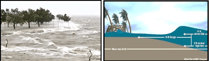
[Source: noaantic.wordpress] [Source: the conversation.com]
FIGURE 1.4: LINE THUNDERSTORMS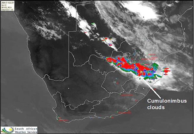
[Source: twitter.com]
FIGURE 1.5: RIVER REJUVENATION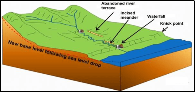
[Source: coolgeography.co.uk]
FIGURE 1.6: RIVER DISCHARGE
[Source: fiden-2phys.vef.edu] [Source: sharetechnote.com]
FIGURE 2.2: RIVER PROFILE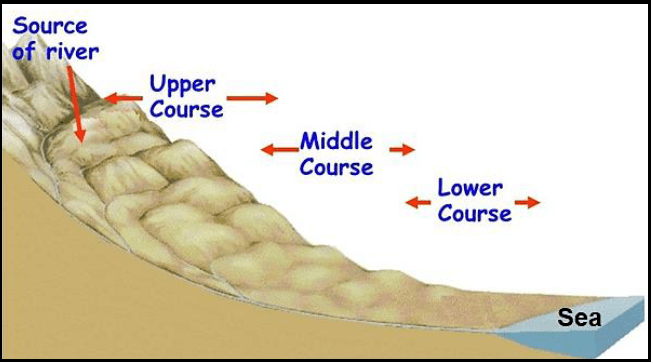
[Source: geoforcexc.com]
FIGURE 2.3: MID-LATITUDE CYCLONES
COLD FRONT EXPECTED TO BRING A BLANKET OF SNOW A cold front is expected on Friday‚ which is going to bring much-needed rain relief in the Western Cape. The cold front is going to be caused by a strong mid-latitude cyclone which will sweep fronts into the south-western districts on Monday. This is going to result in maximum inland temperatures ranging from 2 to 10 degrees Celsius. Heavy rainfall and snow are expected to come with these cold fronts. According to Snow Report South Africa‚ a community organisation based in KwaZulu-Natal‚ we should be expecting snow across the country as the cold front makes its way from the west coast to the east coast. ‘By Sunday evening‚ we should see some snowfall over the peaks of the majority of the Cape mountains‚’ says SRSA on their Facebook page. ‘We could also well see some snow pushing into KZN this time around‚ with [snowfall] predicted for Underberg‚ Mooi River‚ Rosetta and Impendle.’ Areas in the Northern Cape are also expected to receive snow and as the cold front moves to the east‚ the Eastern Cape should receive its own fair share of snowfall according to the report. [Source: www.goexpress.co.za] |
FIGURE 2.4: DIFFERENCES BETWEEN RURAL AND URBAN CLIMATE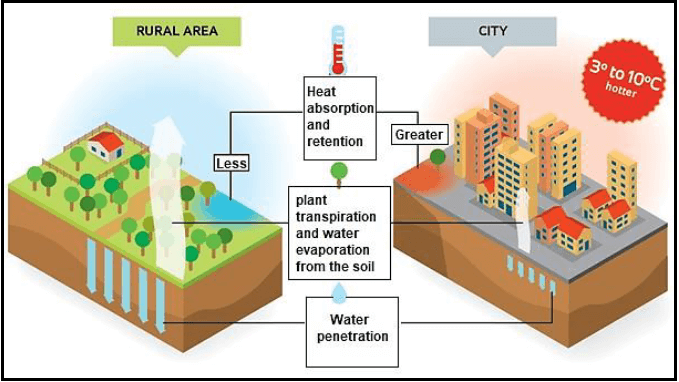
[Source: weatherstreet.com]
FIGURE 2.5: FLUVIAL LANDFORMS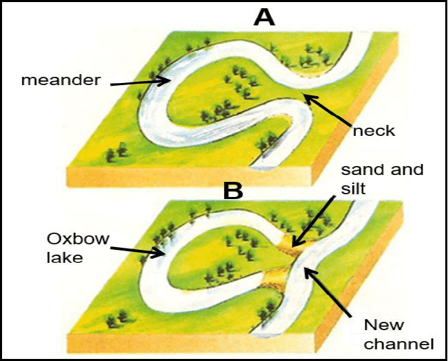
[Source: revisionworld.com.com]
FIGURE 2.6: DRAINAGE DENSITY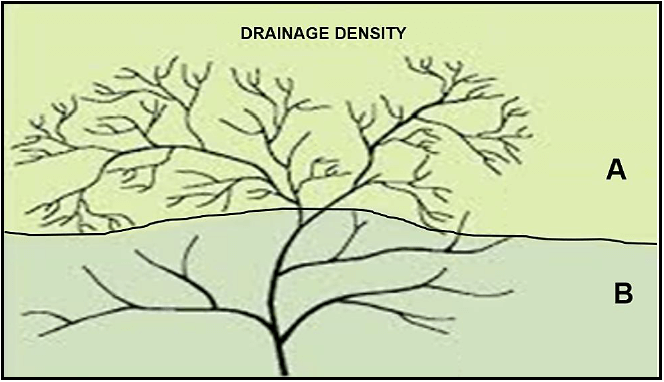
[Source: sageography.co.za]
FIGURE 3.3: URBAN SETTLEMENT ISSUES: URBAN BLIGHT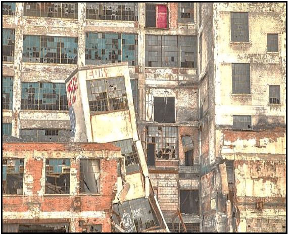
[Source: opinionfront.com]
FIGURE 3.4: URBANISATION OF THE WORLD POPULATION
CORONAVIRUS REVEALS THE DOWNSIDE OF URBANISATION The relentless march of urbanisation around the world, has been coming for a long time.The United Nations estimated that, in 2009, half the world’s population lived in urban areas for the first time in human history. Over 4 billion people live in cities today, six times more than in 1950. In 2000, there were 371 cities of a million or more people in the world; global trends go beyond what you would expect simply as the natural outcome of urban growth. [Adapted from www.national review.com] |
FIGURE 3.5: INFOGRAPHIC ON GOLD MINING
[Source: enwikipedia.com] Spiralling labour and energy costs are putting pressure on the financial performance of South African gold mines, but the solution could be found in adopting digital technologies. [Adapted from article in miningreview.com] |
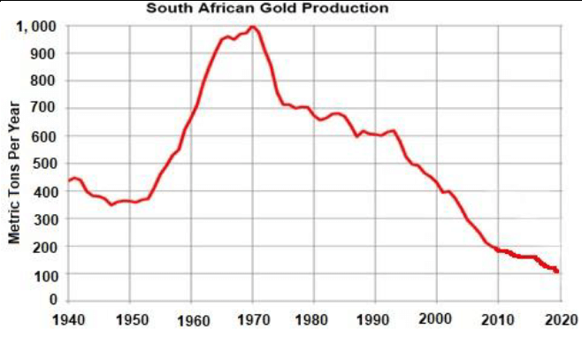
FIGURE 3.6: STRATEGIES FOR INDUSTRIAL DEVELOPMENT – RICHARDS BAY
MAJOR PALM OIL REFINERY SET TO GO July 6, 2019 The Richards Bay Development Zone and the City of uMhlathuze have been commended for paving the way for the construction of a R1,3-billion palm oil refinery. Involved is a major palm plantation company, which also has operations in Indonesia, East Malaysia and some parts of Africa. ‘We congratulate the Development Zone and the uMhlathuze Municipality for working together to make this project possible. This investment will greatly benefit local communities in terms of employment’, said Premier Zikalala. Zikalala said with this and other projects in the pipeline, the Development Zone looks set to attract more than R11,5-billion in investments. The company has already recruited six chemical engineers from across the Province, including eSikhaleni, who are being trained on a two-year programme at their operational plants around the world. ‘Upon completion of their training, they will transfer their skills at the Richards Bay plant once it becomes operational,’ said the Development Zone Stakeholder and Communications Manager, Choice Sihiya. Sihiya said given the scope of the project, there will be mass job creation during the construction and operation phases. ‘We are confident of jobs within the value chain for our small, medium and micro-sized enterprises (SMMEs).’ ‘The potential of supplying and even using raw material to produce local products would be within reach. ‘These would include cooking oil, margarine, soaps, cleaning detergents, body lotions, beauty creams, coffees, chocolates, ice cream and many others. [Source: zululandobserver.co.za] |
FIGURE 4.3: RURAL DEPOPULATION
[Source: proxectorsymbols.es]
FIGURE 4.4: AN URBAN LAND-USE ZONE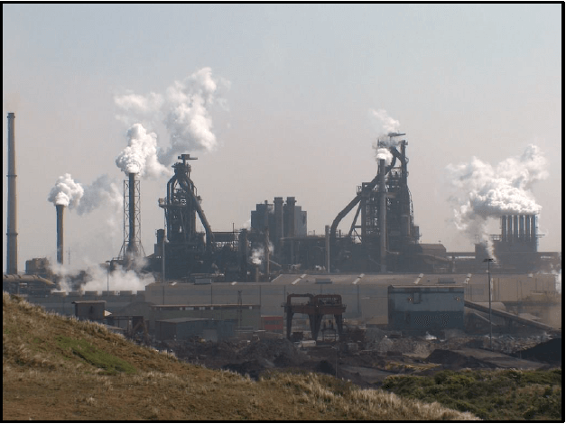
[Source: wikipedia.com]
FIGURE 4.5: SOUTH AFRICA’S INFORMAL SECTOR
South Africa has a job crisis. In the fourth quarter of 2019, 6,14 million people were out of work, an unemployment rate of 27,1%, which is one of the highest rates in the world, along with sub-Saharan African countries like Lesotho, Mozambique and Namibia. [Source: www.forbesafrica.com] |
FIGURE 4.6: SOUTH AFRICA’S CORE INDUSTRIAL REGIONS
[Source: slideplayer.com]
Geography Paper 2 Grade 12 Memorandum - NSC Past Papers And Memos September 2020 Preparatory Examinations
MEMORANDUM
QUESTION 1: MULTIPLE-CHOICE QUESTIONS
1.1 C
1.2 A
1.3 B
1.4 D
1.5 C
1.6 C
1.7 C
1.8 D
1.9 C
1.10 D
1.11 C
1.12 B
1.13 C
1.14 D
1.15 A
(15 x 1) [15]
QUESTION 2: MAPWORK CALCULATIONS AND TECHNIQUES
2.1
2.1.1 MLarger / Bigger (1 x 1) (1)
2.1.2
- The mean annual change in the magnetic declination for Worcester is 2' West/Westwards.
- 1997 declination 23°12' W and 2020 declination 23°58' W.
[Any ONE] (1 x 1) (1)
2.2 Refer to the line from N (block E3) to O (block C6) on the topographical map.
2.2.1 Complete a cross-section from trigonometric station 59 (E3) to trigonometric station 207 (C6). Use the vertical interval of 1 cm to represent 20 m.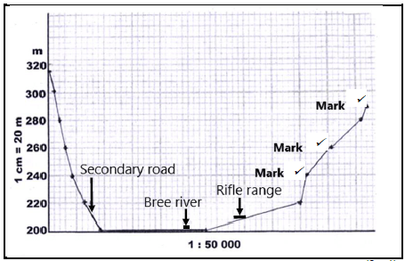
(3 x 1) (3)
2.2.2 Indicate the position of the following on the cross section drawn in QUESTION 2.2.1:
- Secondary road (see graph)
- Rifle range
- Breë River
(3 x 1) (3)
2.2.3 Calculate the vertical exaggeration of the cross-section. Show ALL calculations. Marks will be awarded for calculations.
Formula: ???????? ???????????? = ???????? ?????
?????????? ?????
- VS = 1 cm : 20 m
VS = 1 cm : (20 x 100) cm
VS = 1 : 2 000 ?
HS = 1 : 50 000 ?
?? = 1/2 000
1/50 000
= 1 × 50 000
2 000 x 1 ?
= 25 times ? (4 x 1) (4)
2.2.4 Would the vertical exaggeration of the cross-section make the interpretation of the landscape easier or more difficult?
Give a reason for your answer.
Answer: Easier (1 x 1) (1)
Reason:
- The shape of the features on the landscape is clearer when the vertical scale is made larger/enlarged/exaggeration is increased.
- To represent the topography of the landscape.
- To emphasise vertical features which are too small to identify relative to the horizontal scale.
- By increasing the vertical exaggeration, the topography and gradient can be seen more clearly.
- Specific features are more recognisable /clearer.
- Without vertical exaggeration the cross-section would be flat.
- Larger exaggeration creates a clearer impression of the landscape.
[Any ONE] (1 x 1) (1)
2.3 Refer to area 6 on the orthophoto map.
2.3.1 Calculate the area of the railway shed 6 on the orthophoto map, in m². Show ALL calculations. Marks will be awarded for calculations. Clearly indicate the unit of measurement in your answer.
- 3,5 (cm) x 100 = 350 m [3,4 cm to 3,6 cm] [Range: 340 m – 360 m]
35 (mm) x 10 = 350 m
2,2 ( cm) x 100 = 220 m [2,1 cm to 2,3 cm] [Range: 210 m – 230 m]
22 (mm) x 10 = 220 m
350 m x 220 m = 77 000 m² [Range: 71 400 m² – 82 800 m²]
[Length x Breadth must be in correct sequence.] (5 x 1) (5)
2.3.2 The area 6 on the orthophoto map is the same as the area of railway shed P on the topographical map. Explain why it appears to be smaller on the topographical map.
- The scale of the topographical map is 1 : 50 000 and the scale of the orthophoto map is 1 : 10 000.
- This indicates that the scale of the topographical map is 5 times smaller than the scale of the orthophoto map, making the railway shed area appear smaller on the topographical map.
[Any ONE] (1 x 1) (1)
[20]
QUESTION 3: APPLICATION AND INTERPRETATION
3.1 Refer to the area in blocks A6 to B6 on the topographical map.
3.1.1 Name the nocturnal (night) wind that occurs between X and Y.
- Katabatic (1 x 1) (1)
3.1.2 On the cross-section below, indicate the following:
- Wind direction of the wind named in QUESTION 3.1.1
- Position of Altona

(2 x 1) (2)
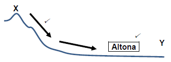
3.1.3 Explain how frost will influence the type of crops farmed at Altona.
- Cold dense air moves downslope causing the dew point temperature to drop below freezing point (0°C) leading to frost – freezes non-frost resistant plants.
(1 x 2) (2)
3.2 Refer to blocks D4 and E5 on the topographical map.
3.2.1 Name ONE landform of fluvial deposition in blocks D4 and E5.
- Floodplain (1 x 1) (1)
3.2.2 Is laminar or turbulent river flow found in blocks D4 and E5? Motivate using evidence to support answer.
Answer: Laminar
Evidence:
- The river is in the lower course/plain/old stage
- The slope is gentle/gentle gradient depositing load
- Wide river
- Marshes
- Floodplain
[Any ONE] (1 + 1 x 2) (3)
3.3 Worcester enjoys an excellent location as a gap town. With reference to this statement:
3.3.1 Explain the meaning of the term gap town.
- A town located at a gap between hills, providing a good defensive site and route centre that led to a trade and market function.
- A town located between or at the entrance of two mountains or poort.
[Any ONE ] [Concept] (1 x 2) (2)
3.3.2 Give TWO map evidences to support the statement that Worcester is a gap town.
- Found at the bottom of the Du Toitskloof / Slanghoek (Huguenot Tunnel) mountain range/pass.
- People using the N2 will stop and buy goods at local businesses and encourages economic growth.
- Encourages tourism
- Encourages trade of goods
- Industrialisation
[Any TWO] (2 x 2) (4)
3.4 Refer to 7 on the orthophoto map.
3.4.1 Is residential area 7 a high- or low-income residential area? Give a reason for your answer.
Answer: High-income residential area
Reason:
- Houses are large
- Stands are large
- High lying – scenic view
- Low density
- Close to golf course / woodland / Veld reserve
- [Any ONE] (1 + 1 x 2) (3)
3.5 Refer to the area demarcated by a white line in the north-east corner on the orthophoto map.
3.5.1 Is the wine cellar / factory at 8 on the orthophoto map market- orientated or raw material-orientated? Give a reason for your answer.
Answer: Raw-material orientated
Reason:
- It is situated close to the raw material – grapes (Vineyard fields)
- Processing occurs near the raw material
[Any ONE] (3) (1 + 1 x 2)
3.5.2 Suggest how the wine cellar / factory in QUESTION 3.5.1 can improve the local economy of Worcester.
- Worcester can have a wine festival.
- Tours can be organized through the vineyards and wineries.
- They could have wine tasting tours.
- Tourists bring money into the town.
- Jobs are created (in manufacturing of grape products/ processing).
- Export of grape products will boost the local economy.
- Improved infrastructure attracts business (can give examples).
- Multiplier effect will result in more economic development.
- Selling grape products (can give examples) to the locals/tourists. [Any TWO] (2 x 2) (4)
[25]
QUESTION 4: GEOGRAPHICAL INFORMATION SYSTEMS (GIS)
4.1 During a major flooding disaster, accessibility to the Brandvlei Dam in blocks E6 and F6 on a topographical map, would be limited. To determine the extent of the damage, remote sensing could be a useful tool.
4.1.1 Give an example of a remote sensing device that can be used to capture the extent of the damage due to flooding.
- Satellites/drones
NOTE: Do not accept hand-held camera/ camera.(1) (1 x 1) (1)
4.1.2 Explain how remote sensing could assist in monitoring the environmental impact of flooding in the area.
- Photographs can be taken over specific periods to analyse the environmental impact over time along the Holsloot River.
- Data about environmental damage can be collected for farmers.
- Large areas can be captured as images to see environmental impact in the area created from farming.
- Information could be used to determine the areas most affected and strategies put in place that would focus on those areas.
- It can be used to track environmental changes and development in an area over time.
- Information can be used to educate farmers / locals about the importance of being environmentally sensitive.
[Any TWO]
(2 x 2) (4)
4.2 A farmer decides to use data manipulation on his farm situated in blocks
- G9 and 10.
4.2.1 Explain the term data manipulation.
- When different layers of data are standardised and integrated to study a specific problem/query [CONCEPT] (1 x 1) (1)
4.2.2 Evaluate how data manipulation assists farmers in blocks G9 and 10 to practise sustainable farming methods.
- The farmer will evaluate the gradient
- Drainage density
- Soil profile (data layer)
- To describe what product, type of farm and farming methods to use to gain max use of area
[Any TWO] (2 x 2) (4)
4.3 The sketch map below is a plan view of the Aan de Doorns settlement and its attribute data, located in block F10 and G10.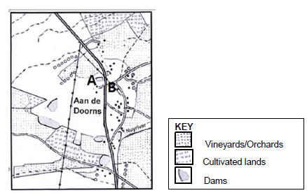
4.3.1 Define the term attribute data.
- Information that describes the spatial objects or features
[CONCEPT] (1 x 1) (1)
4.3.2 Use the symbols (letters of the alphabet) shown in the key above to locate the position of the following attribute data for the Aan de Doorns settlement on the sketch map.
- A – Cellar (See sketch map) ?
- B – School (See sketch map) ? (2 x 1) (2)
4.3.3 State TWO attributes of B – School in QUESTION 4.3.2.
- 33°41’52’’ S 19°29’39’’ E ?
- Located in Aan de Doorns 220 m (above sea level) ?
- Access by road (other road) / close to arterial road (R43)?
- Power line nearby ?
- SE of Worcester ?
[Any TWO] (2 x 1) (2)
[15]
TOTAL: 75
Geography Paper 1 Grade 12 Memorandum - NSC Past Papers And Memos September 2020 Preparatory Examinations
Marking guideline
The following marking guideline has been developed to standardise marking across the Province.
Marking
- ALL selected questions MUST be marked, irrespective of whether it is correct or incorrect.
- Candidates are expected to make a choice of THREE questions to answer. If all questions are answered, only the first three questions are marked.
- A clear neat tick must be used:
- If ONE mark is allocated, ONE tick must be used.
- If TWO marks are allocated, TWO ticks must be used.
- The tick must be placed at the FACT that a mark is being allocated for.
- Ticks must be kept SMALL, as various layers of moderation may take place.
- Incorrect answers must be marked with a clear, neat cross. ˣ
- Use MORE that one cross across a paragraph/discussion style questions to indicate that all facts have been considered.
- Do NOT draw a line through an incorrect answer.
- Do NOT underline the incorrect facts
- Where the maximum marks have allocated in the first few sentences of a paragraph, place an M over the remainder of the text to indicate that the maximum marks have been achieved.
For the following action words, ONE word answers are acceptable: give, list, name, state, identify etc.
For the following action words, a FULL sentence must be written: describe, explain, evaluate, analyse, suggest, differentiate, distinguish, define, discuss, why how The following action words need to be read within its context to determine whether a ONE word answer or FULL sentence is required: provide, what, tabulate
Totalling and transferring of marks
- Each sub-question must be totalled:
- Each question has sub-sections, therefore six sub-totals per question required
- Sub-section totals to be written in the right-hand margin at the end of the sub- section and underlined
- Sub-total must be written legibly
- Total sub-totals and transfer total to the top left-hand margin next to the question number
- Transfer total to cover of ANSWER BOOK.
Moderation
Marking on each level of moderation is done in the same way as the initial marking. All guidelines for marking must be adhered to.
If a mark for a sub-question is changed after moderation, the moderator must strike through the marker’s mark and write down the new mark. 12 16
QUESTIONS
SECTION A: CLIMATE, WEATHER AND GEOMORPHOLOGY
QUESTION 1
1.1
1.1.1 B (1)
1.1.2 A (1)
1.1.3 B (1)
1.1.4 A (1)
1.1.5 B (1)
1.1.6 A (1)
1.1.7 A (1) (7 x 1) (7)
1.2
1.2.1 F (drainage basin) (1)
1.2.2 I (water table) (1)
1.2.3 G (catchment) (1)
1.2.4 B (episodic) (1)
1.2.5 C (trellis) (1)
1.2.6 D (rectangular) (1)
1.2.7 H (exotic) (1)
1.2.8 E (abstraction) (8 x 1) (8)
1.3
1.3.1 Mature stage (1) (1 x 1) (1)
1.3.2 High waves/flooding/storm surge (1) (1 x 1) (1)
1.3.3 There is more friction on the land which decreases wind speed (1) Moisture supply is reduced (1) (2 x 1) (2)
1.3.4
- Cumulonimbus clouds form which results in torrential rain, hail, lightning and thunder (2)
- There is a steep pressure gradient that cause winds of hurricane strength (2)
- Air pressure at the centre drops to below 1 000 mb (2)
[ANY TWO] (2 x 2) (4)
1.3.5
- Abnormally high waves caused by strong winds (1) (1 x 1) [CONCEPT] (1)
- This forward movement in the same direction as the rotation would increase the intensity of the wind speed and thus cause abnormally high waves (2) (1 x 2) (2)
-
- Damage to property because of flooding (2)
- Loss of life (2)
- Will affect all outdoor recreation activities (e.g. swimming) (2)
- Infrastructure would be destroyed (2)
- Aesthetic beauty of country would be damaged (2)
- Contamination of water/water borne diseases (2)
- It will cause coastal erosion (2)
[ANY TWO] (2 x 2) (4)
1.4
1.4.1 Zone between two air masses with different moisture content (1) [CONCEPT] (1 x 1) (1)
1.4.2
- They cover a greater/widespread area (1)
- Formation of cumulonimbus clouds along the moisture front/in a line (1) (2 x 1) (2)
1.4.3
- Air on the eastern side is more unstable (2)
- Warm moist air from the east (more moisture) reaches the interior (2)
OR - Air on the western side is more stable (2)
- Air that feeds in from the west is cold and dry (2)
[CANDIDATES CAN REFER TO EITHER THE EASTERN OR WESTERN SIDE.] (2 x 2) (4)
1.4.4
- A weakened Kalahari High Pressure Cell facilitates vertical rising of air above the interior (2)
- This encourages increased convergence of air masses from well- developed high pressure cells (2)
- The South Indian high is found away from the land and further south in summer (2)
- This allows warmer moist air to diverge from the South Indian high pressure cell towards the interior (2)
- In summer, the South Atlantic high pressure extends along the south-east coast of the country (2)
- Cold and dry air diverges from the South Atlantic high pressure cell to meet the warm moist air mass from the South Indian high pressure cell in the interior of the country (2)
[ANY FOUR] (4 x 2) (8)
1.5
1.5.1
- When a river starts to erode again (1)
- The erosive power, speed and carrying capacity of the river is renewed (1)
[CONCEPT] (1 x 1) (1)
1.5.2
- Abandoned terrace (1)
- Incised meanders (1) Waterfall / Knickpoint (1)
- Sea level has dropped (1)
[ANY TWO] (2 x 1) (2)
1.5.3
- Uplift of land through tectonic forces in the Earth’s crust causes renewed erosion (2)
- The sea level drops which allows more downward erosion (2)
- Increased volume of water enlarges the erosion capacity of the stream (2)
- A significant increase in rainfall over a prolonged period increases the erosive potential of the river (2)
[ANY TWO] (2 x 2) (4)
1.5.4
- Found in folded mountains/steep land (2)
- Soil is too shallow for agriculture hence of no use to farmers (2)
- Excessive soil erosion has taken place making the soil infertile (2)
[ANY TWO] (2 x 2) (4)
1.5.5
- Valleys within in valleys would make the land steeper and more difficult for farmers to cultivate (2)
- This would promote soil erosion and discourage the use of machinery (2)
- Terraces that are too high would hamper a farmer’s access to water in the river (2)
- Narrow terraces would limit the amount of land to cultivate (2)
- Faster flowing water at the knickpoint (waterfall) makes it inaccessible for irrigation (2)
- Entrenched/incised meanders have steep/deep valleys that limits a farmer’s access to water (2)
- Steep slopes make the construction/erection of infrastructure difficult and expensive (2)
[ANY TWO] (2 x 2) (4)
1.6
1.6.1 River discharge refers to the total volume of water passing through a given point in a river (1)
[CONCEPT] (1 x 1) (1)
1.6.2
- A – laminar (1)
- B – turbulent (1) (2 x 1) (2)
1.6.3
- A – water flows smoothly in thin layers (1)
- B – water flows in tumbling circular movements (1) (2 x 1) (2)
1.6.4
- It would be easier to access for irrigation purposes (2)
- This type of flow is normally associated with gentle relief where most farming takes place (2)
- It encourages the deposition of fertile soil (2)
[ANY ONE] (1 x 2) (2)
1.6.5
- Turbulent flow occurs in the upper course of the river because the river has a rough and uneven bed (2)
- This would result in downward cutting and a steep valley (2)
- Higher discharge is prevalent in the middle course due to tributaries joining the river (2)
- Laminar flow occurs because of a smoother river bed (2)
- Lateral erosion causes a v-shaped valley with gentle slopes in the middle course (2)
- Discharge is at its highest in the lower course (2)
- Laminar flow dominates due to a flat river bed and greater volume of water (2)
- Deposition results in a wide and gently sloping valley to form (2)
[ANY FOUR] (4 x 2) (8)
[75]
QUESTION 2
2.1
2.1.1 F/coastal low (1)
2.1.2 H/DALR (1)
2.1.3 A/polar front (1)
2.1.4 E/cyclone (1)
2.1.5 I/anticyclone (1)
2.1.6 C/microclimate (1)
2.1.7 D/hurricane (1)
2.1.8 B/aspect (1) (8 x 1) (8)
2.2
2.2.1 upper (1)
2.2.2 lower (1)
2.2.3 middle (1)
2.2.4 upper (1)
2.2.5 middle (1)
2.2.6 upper (1)
2.2.7 lower (1) (7 x 1) (7)
2.3
2.3.1 The boundary of an advancing mass of cold air, in particular the leading edge of a cold mass of cold air behind the warm sector (1) [CONCEPT] (1 x 1) (1)
2.3.2
- Forms when frictional drag during the wave stage of a mid-latitude cyclone causes warm air to be uplifted by cold air thus creating clear boundaries between the two masses of air (2)
- Forms when cold air forces warm air to rise (2)
[ANY ONE] (1 x 2) (2)
2.3.3 ‘... the cold front makes its way from the west coast to the east coast.’ (2) (1 x 2) (2)
2.3.4 Rapid rising air along the steep pressure gradient of the cold front causes cumulonimbus clouds and heavy rain (2) (1 x 2) (2)
2.3.5 HEAVY RAINFALL
- Fills rivers and dams (2)
- Provides water for farming, domestic and industrial use (2)
- Good winter rainfall is ideal for the growth of winter crops e.g. grapes (2)
- Encourages the growth of natural vegetation that enhances the aesthetic beauty of a place (2)
- Flooding can damage property and crops (2)
- Heavy rain prevents commercial and subsistence fishermen from going out to sea (2)
SNOW
- Can attract tourists (2)
- Hospitality industry benefits from tourists (2)
- Snow can damage crops and kill livestock (2)
- Can hamper communication/infrastructural networks (2)
[CANDIDATE MUST REFER TO BOTH RAINFALL AND SNOW]
[ANY FOUR] (4 x 2) (8)
2.4
2.4.1 Temperature (heat)/humidity/evaporation (1) [ANY ONE] (1 x 1) (1)
2.4.2
- It shows higher temperatures over the urban area surrounded by lower temperatures in the rural areas (2)
- There is no evidence of an accumulation of pollutants over the city (2)
[ANY ONE] (1 x 2) (2)
2.4.3
- Vehicles increase the production of pollutants that absorb heat (2)
- Appliances like stoves, air conditioners, fridges etc. generate heat (2)
- Industries produce heat (2)
- Businesses like restaurants generate heat (2)
[ANY TWO] (2 x 2) (4)
2.4.4
- There are more condensation nuclei/hygroscopic nuclei in a city (2)
- Hygroscopic nuclei are essential for condensation to take place (2) (2 x 2) (4)
2.4.5
- Causes heat stress (2)
- Causes fatigue and dehydration (2)
- Death among the elderly who are more vulnerable towards higher temperatures (2)
[ANY TWO] (2 x 2) (4)
2.5
2.5.1
- Flat terrain (1)/
- sand and silt associated with deposition (1)
[ANY ONE] (1 x 1) (1)
2.5.2
- A – meander (1)
- B – oxbow lake (1) (2 x 1) (2)
2.5.3
- There is a decrease in flow velocity because of the flat land (2)
- An increase in lateral erosion will cause the river to meander (2)
- Repeated undercutting at the outer bank and deposition on the inner bank (2)
[ANY TWO] (2 x 2) (4)
2.5.4
- Erosion on the outer bank and deposition on the inner bank causes the meander neck to become narrower, resulting in a meander loop (2)
- Flooding of the river causes the water to cut through the neck of the meander loop (2)
- The cut off meander loop forms the oxbow lake (2)
[ANY TWO] (2 x 2) (4)
2.5.5
- The oxbow lake is a source of water to farmers (2)
- If it dries up to form a meander scar, it will reduce the amount of water available to farmers (2) (2 x 2) (4)
2.6
2.6.1
- Relationship between the length of streams in a drainage basin and the size of the drainage basin/total length of streams in a drainage basin divided by the total area of the drainage basin (1)
- Number of streams in a drainage basin (1)
[ANY ONE – CONCEPT] (1 x 1) (1)
2.6.2
- A – high (1)
B – low (1) (2 x 1) (2)
2.6.3
- Removal of vegetation will increase the drainage density as the water is not trapped in the vegetation and there will be less infiltration (2)
- There will be more surface run-off and thus more streams (2) (2 x 2) (4)
2.6.4
- Low rainfall will result in low density as fewer streams flow (2)
- Gentle gradient increases infiltration resulting in lower density (2)
- Permeable rocks allow more infiltration and thus fewer surface streams develop (2)
- Porous rocks encourage infiltration and therefore density will be lower (2)
- Dry soils absorb water therefore stream run-off is reduced and drainage density is low (2)
- Dense vegetation cover causes greater infiltration and lower drainage density (2)
[ANY FOUR] (4 x 2) (8)
[75]
QUESTION 3
3.1
3.1.1 Situation (1)
3.1.2 Restitution (1)
3.1.3 rural (1)
3.1.4 Large scale (1)
3.1.5 ‘Brain drain’ (1)
3.1.6 Site (1)
3.1.7 star shaped (1)
3.1.8 Aids (1) (8 x 1) (8)
3.2 3.2.1 B/oil and gas (1)
3.2.2 C/bridge (1)
3.2.3 A/minerals (1)
3.2.4 C/raw material (1)
3.2.5 B/GEAR (1)
3.2.6 B/North West (1)
3.2.7 C/international exports (1) (7 x 1) (1)
3.3
3.3.1 The buildings deteriorated and are not maintained (1) (1 x 1) (1)
3.3.2
- Landlords do not maintain buildings (1)
- Illegal occupation of buildings (1)
- Overcrowding of properties (1)
- Poor service delivery (1)
- Sub-letting (1)
- Future zone of expansion of the CBD (1)
[ANY TWO] (2 x 1) (2)
3.3.3
- Most of the buildings are owned by private people and hence local authorities have no jurisdiction over them (2)
- Landlords/landowners are waiting to sell properties when invasion and succession of the CBD occurs and thus have no interest in renovating them (2)[ANY ONE] (1 x 2) (2)
3.3.4 The front of the buildings could be preserved to maintain the heritage of an area while the rest of it could be rebuilt/refurbished (2) (1 x 2) (2)
3.3.5
- Increases property values (2)
- Environment becomes more pleasant and aesthetically pleasing to attract more investors in the area (2)
- To prevent loss of money from the city’s coffers through disinvestment from the area (2)
- To make the area safer and more secure to attract more tourists who would bring more revenue to the area (2)
- Preserves the heritage of buildings which attracts tourists (2) It encourages different forms of entrepreneurship (2)
- A variety of entertainment facilities generates income to the area (2)
[ANY FOUR] (4 x 2) (8)
3.4
3.4.1 Is the process of the increasing percentage of the population living in urban areas rather than rural areas (1)[CONCEPT] (1 x 1) (1)
3.4.2 4 billion (1) (1 x 1) (1)
3.4.3
- Larger workforce with diverse skills (1)
- Easier access to mass transport (1)
- Public services to cultural institutions (1)
- Internet service to grocery and take-out delivery (1)
[ANY ONE] (1 x 1) (1)
3.4.4
- Rural-urban migration increases the urban population (2)
- More births than deaths in an urban area would result in a natural increase of the population (2)
[ANY ONE] (1 x 2) (2)
3.4.5
- Increased urban populations would create a greater demand for formal housing (2)
- Shortage of formal housing would leave people with no alternative but to live in informal housing (2)
[ANY ONE] (1 x 2) (2)
3.4.6
- High density of informal settlements would cause infectious diseases to be easily spread amongst people (2)
- Lack of basic services (e.g. potable water) would create unhygienic conditions for the disease to spread (2)
- Human behaviour (social ills) would encourage contact and increase the spread of a virus (2)
- Lack of medical facilities/personnel would prevent a timeous response to the treatment of diseases (2)
- No access to community halls in case of quarantine measures (2)
[ANY TWO] (2 x 2) (4)
3.4.7
- An increase in the urban population would mean that there would not be enough jobs for everyone (2)
- Unemployment would deepen poverty levels (2)
- Informal trading would deprive government/municipal coffers (2)
- Municipalities would not have the budgets to keep up with the demand for services/examples (2)
- Non-payment of services would lead to municipal shortfalls (2) Urban blight discourages investors (2)
- Tourism is affected (2)
- Increases reparations on infrastructure due to increased usage by more people (2)
- Increase in pollution causes pressure on public health facilities (2)
[ANY TWO] (2 x 2) (4)
3.5
3.5.1 Decreases (1) (1 x 1) (1)
3.5.2
- Labour costs/safety (1)
- Energy costs (1) (2 x 1) (2)
3.5.3
- Reduction in gold reserves/ore (2)
- Gold is a non-renewable resource (2)
[ANY ONE] (1 x 2) (2)
3.5.4
- Digital technology is expensive and will add to production costs (2)
- Unskilled labourers may break/damage equipment (2)
- Digital technology requires skilled labour that would require competitive market salaries (2)
- Technical glitches with equipment would hamper production (2)
[ANY ONE] (1 x 2) (2)
3.5.5
- Strike action for better wages and benefits (2)
- Factional fighting between locals and migrant miners (2)
- HIV and Aids causes high absenteeism (2)
- HIV and Aids pandemic results in a loss of skilled labourers (2)
[ANY TWO] (2 x 2) (4)
3.5.6
- Workers should be given shares/profit sharing to provide an incentive to increase production (2)
- Improve salary adjustments to be in sync with the CPI (2)
- Create more collective bargaining councils to improve incentives and working conditions for miners (2)
- Improve benefits of workers (medical aid, housing etc.) (2) Improve safety in mines (examples) (2)
[ANY TWO] (2 x 2) (4)
3.6
3.6.1 KwaZulu-Natal/KZN (1) (1 x 1) (1)
3.6.2 Palm oil refinery (1) (1 x 1) (1)
3.6.3
- Employment opportunities (1)
- Skills uplifted/Fourth industrial revolution skills (1)
- Multiplier effect (1)
- Access to better infrastructure (1)
- Poverty reduced (1)
- Standard of living improves (1)
- Access to more services (1)
- Social responsibility programs (1)
[ANY ONE] (1 x 1) (1)
3.6.4
- Deep port harbour would encourage imports and exports (2)
- Raw materials necessary for the production process are accessible (2)
- Coalfields provide cheap electricity for the refinery (2)
- Large amounts of cheap flat land available for industries/refinery (2)
- Flat land has resulted in the development of an extensive transport network (2)
- Access to large water supply as the region is in the wetter eastern half of the country (2)
- Location on the eastern half of the country gives it accessibility to international markets (2)
[ANY TWO] (2 x 2) (4)
3.6.5
- Local economy is dominated by a few low value-adding large firms (2)
- Small firm sector is undeveloped (2)
- Local economy is subject to boom-bust cycles that are associated with the construction of mega-projects (2)
- There are still infrastructural deficiencies in container-handling, water supply, road connections, toxic waste dump and policing (2)
- Local bureaucracy hampers industrial development (2)
- There is a need for economic diversification (2)
- A need to create an entrepreneurial environment for small business (2)
- Development of a new skills base for unskilled labourers (2)
- Strengthening of rural-urban linkages (2)
- Minimal involvement of women in production and SDI development (2)
- High levels of pollution deter investors to the SDI (2)
[ANY FOUR] (4 x 2) (8)
[75]
QUESTION 4
4.1
4.1.1 C/hierarchy (1)
4.1.2 B/Central business district (CBD) (1)
4.1.3 D/radial (1)
4.1.4 C/multiple nuclei (1)
4.1.5 A/threshold population (1)
4.1.6 B/Specialised (1)
4.1.7 D/planned regional (1) (7 x 1) (7)
4.2
4.2.1 trade (1)
4.2.2 food insecurity (1)
4.2.3 favourable (1)
4.2.4 GNP (1)
4.2.5 Sugar cane (1)
4.2.6 Primary (1)
4.2.7 Free trade (1)
4.2.8 beneficiation (1) (8 x 1) (8)
4.3
4.3.1
- Decrease in the number of people living in rural areas (1)
[CONCEPT] (1 x 1) (1)
4.3.2
- No buildings/farmhouses (1)
- No crops/livestock (1)
- ‘... otherwise we will remain here alone’
[ANY TWO] (2 x 1) (2)
4.3.3 Scarecrow is supposed to protect crops from birds, yet there are no crops cultivated to protect (2) (1 x 2) (2)
4.3.4
- Housing (1)
- Electricity (1)
- Water (1)
- Schools (1)
- Hospitals (1)
- Roads (1)
[ANY TWO] (2 x 1) (2)
4.3.5
- Only older people and children left behind (2)
- ‘Brain drain’ as educated/skilled people leave (2)
- Family units are broken up (2)
- More susceptible to crime (2)
[ANY TWO] (2 x 2) (4)
4.3.6
- Land has been redistributed to people with no knowledge of agriculture, thus land becomes unproductive and people leave (2)
- There is no training and support for new owners so there is little chance for productivity on farms and the creation of jobs (2)
- New owners of redistributed land may lack capital to develop farms thus fewer jobs available (2)
- Re-distributed land not cultivated at all (2)
- Redistribution may not stimulate economic growth; thus, people leave (2)
- There is no change from subsistence to commercial farming, hence lower output means less jobs are created (2)
- Disagreements prevail between traditional leaders and new recipients that renders land unproductive (2)
- Nepotism and corruption with regards to how land is redistributed could decrease agricultural production forcing people to leave (2)
[ANY TWO] (2 x 2) (4)
4.4
4.4.1
- An area in an urban settlement with one main function (1)
[CONCEPT] (1 x 1) (1)
4.4.2 Industrial (Heavy industry) (1) (1 x 1) (1)
4.4.3
- Flat land/space for expansion (1)
- Away from residential areas (1)
- Transport (1)
- Water (1)
- Power facilities (1)
[ANY ONE] (1 x 1) (1)
4.4.4
- Air pollution can affect the health of people (2)
- Noise pollution disrupts the quality of life of people (2)
- Waste disposal can cause water pollution (2)
- Contamination of ground water (2)
- Increase of acid rain (2)
- Destruction of bio-diversity (2)
- Ecosystems destroyed (2)
[ANY TWO] (2 x 2) (4)
4.4.5
- An efficient road transport network is needed for easy access by labourers, raw materials etc. (2)
- Railway network for transport of bulky raw materials and goods (2)
- Harbour for the export and import of goods and raw materials (2)
- Deep port harbour to facilitate the trade of bulkier goods and raw materials (2)
- A high quality of municipal services (water) for cooling of machinery in industries (2)
- An adequate supply of power to facilitate use of machinery (2)
- Good telecommunications network (2)
[ANY FOUR] (4 x 2) (8)
4.5
4.5.1 6,14 million (1) (1 x 1) (1)
4.5.2
- ‘... is one of the highest rates in the world; (1)
- 6,10 million people out of work (1)
- South Africa has a job crisis (1)
- Unemployment rate is 27,1% (1)
[ANY ONE] (1 x 1) (1)
4.5.3
- Provides jobs (1)
- Allows people with no formal education/skills to work (1)
- Important space for entrepreneurs (1)
[ANY ONE] (1 x 1) (1)
4.5.4
- They are frequently harassed by local authorities (2)
- A lack of access to proper trading facilities (2)
- No storage facilities for their goods (2)
- They do not have skills or formal education (2)
- They cannot obtain credit/loans from banks (2)
- Forced to borrow from money lenders at high interest rates (2)
- High transport costs to access markets (2)
[ANY TWO] (2 x 2) (4)
4.5.5
- Reduces profits of formal sector as they sell cheaper goods (2)
- Formal sector will thus make a smaller contribution to the economy through taxes (2)
- Formal sector businesses may have to close (2) Loss of jobs in the formal sector (2)
- This increases the amount of people who now turn to the informal sector (2)
- Clutter formal business areas/causing litter (2)
- Associated with noise pollution in formal business areas (2)
- Discourages people supporting formal businesses (2)
- They spoil the aesthetics of the area discouraging further formal investment (2)
- Encourages crime in these formal business areas (2)
[ANY FOUR] (4 x 2) (8)
4.6
4.6.1 South Western Cape (1) (1 x 1) (1)
4.6.2
- Industrial region 4 has access to the sea/harbour (2)
- Region 1 in landlocked in the interior (2)
[ANY ONE] (1 x 2) (2)
4.6.3
- The natural bay seaport (harbour) promotes bulk transport that the motor industry requires (2)
- The harbour facilitates the easier export of motor vehicles to overseas markets (2)
[ANY ONE] (1 x 2) (2)
4.6.4
- They have been taught Fourth-industrial revolution skills e.g. robotics which will increase efficiency in the workplace (2)
- They are exposed to modern/cutting edge technological skills (2)
[ANY ONE] (1 x 2) (2)
4.6.5
- Wide variety of raw materials to support industrial development (2)
- Access to water supply from rivers/wetter eastern half (2)
- Enough flat land for the development of industries (2)
- Good energy supply from nearby coalfields (2)
[ANY TWO] (2 x 2) (4)
4.6.6
- There would be an overconcentration of people and activities (2)
- This would lead to unemployment as there would not be enough jobs (2)
- There would be widespread poverty (2)
- A shortage of housing would result in the development of informal settlements (2)
- Crime and other social ills (examples) would increase (2)
- Road rage would be the result of traffic congestion (2)
- Disruption in services like water and electricity due to the overconcentration of people (2)
- Violent protests over poor service delivery (2)
[ANY TWO] (2 x 2) (4)
[75]
GRAND TOTAL: 225
Geography Paper 2 Grade 12 Questions - NSC Past Papers And Memos September 2020 Preparatory Examinations
RESOURCE MATERIAL
- An extract from topographical map 3319 CB WORCESTER.
- Orthophoto map 3319 CB 15 WORCESTER.
- NOTE: The resource material must be collected by schools for their own use.
INSTRUCTIONS AND INFORMATION
- Write your NAME in the space provided on the cover page.
- Answer ALL the questions in the spaces provided in this question paper.
- You are provided with a 1 : 50 000 topographical map (3319CB WORCESTER) and an orthophoto map (3319 CB 15 WORCESTER) of a part of the mapped area.
- You must hand the topographical map and the orthophoto map to the invigilator at the end of this examination session.
- You may use the blank page at the end of this question paper for all rough work and calculations. Do NOT detach this page from the question paper.
- Show ALL calculations and formulae, where applicable. Marks will be allocated for these.
- Indicate the unit of measurement in the final answer of calculations, e.g. 10 km; 2,1 cm.
- You may use a non-programmable calculator and a magnifying glass.
- The area demarcated in BLACK AND RED on the topographical map represents the area covered by the orthophoto map.
- The following English terms and their Afrikaans translations are shown on the topographical map:
ENGLISH
Aerodrome
Golf course
Model aircraft club
Hospital
Sewerage works
Race track
Canal
Cemetery
Wine cellar
Horse riding club
Brickworks
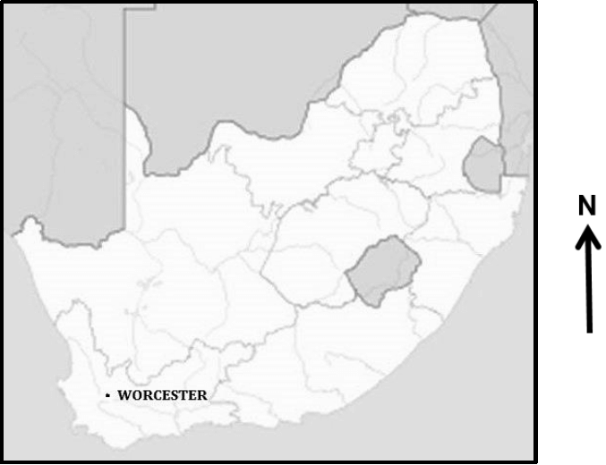
GENERAL INFORMATION ON WORCESTER Worcester is a gap town in the Western Cape, South Africa. It is located 120 kilometres north-east of Cape Town on the N1 highway through the Huguenot Tunnel or by driving through spectacular mountain passes north to Johannesburg.
Coordinates: 33°38ʹʹ42ʹS 19°26ʹʹ37ʹE |
QUESTIONS
QUESTION 1: MULTIPLE-CHOICE QUESTIONS
The questions below are based on the 1 : 50 000 topographical map (3319 CB WORCESTER) as well as the orthophoto map of the part of the mapped area. Various options are provided as possible answers to the following questions. Choose the answer and write only the letter (A–D) in the block next to each question.
1.1 The map index to sheet of the orthophoto map north of Worcester is …
- 3319 CB 9.
- 3319 DA 6.
- 3319 CB 10.
- 3319 CB 20.
1.2 The primary activity found at 1 on the orthophoto map is/an …
- orchards and vineyards.
- mining.
- cultivated lands.
- quarry.
1.3 The building at 2 on the orthophoto map is a …
- shop.
- hospital.
- school.
- factory.
1.4 The type of road labelled 3 on the orthophoto map is a/an … road.
- other
- main
- secondary
- arterial
1.5 The feature found at 4 on the orthophoto map is a …
- monument.
- golf course.
- cemetery.
- stadium.
1.6 The mean annual change on the topographical map is …
- 2’ Eastwards.
- 23°12’ West.
- 2’ Westwards.
- 23°12’ East.
1.7 The feature found at 33°39’45”S and 19°25’45”E on the topographical map is a …
- race track.
- caravan park.
- horse riding club.
- model aircraft club.
1.8 The fluvial landform along the Breë River in block E6 on the topographical map is a …
- waterfall.
- rejuvenation.
- rapid.
- braided stream.
1.9 The sewerage works found in block D8 is located in the …
- industrial zone.
- residential zone.
- rural-urban fringe.
- commercial zone.
1.10 The dominant drainage pattern in block E8 on the topographical map is …
- radial.
- centripetal.
- trellis.
- parallel.
1.11 The main street plan at K in block C7 on the topographical map is a/an … pattern.
- radial
- unplanned irregular
- gridiron
- planned irregular
1.12 The true bearing of bench mark 214,8 in block C3 from spot height 471, (L), in block A4 on the topographical map is …
- 16°.
- 216°.
- 46°.
- 164°.
1.13 A human factor responsible for the location of the industrial area at 5 on the orthophoto map is …
- stable ground.
- climate.
- transport.
- CBD.
1.14 The brickworks in block A1 on the topographical map is an example of a … activity.
- quaternary
- tertiary
- primary
- secondary
1.15 The landform at M in block G8 on the topographical map is a …
- saddle.
- spur.
- koppie.
- valley.
(15 x 1) [15]
QUESTION 2: MAPWORK CALCULATIONS AND TECHNIQUES
2.1 The magnetic declination in 2020 for the topographical map is 23°58' W of TN.
2.1.1 Will the declination become larger or smaller from the time it was surveyed? (1 x 1) (1)
2.1.2 Give a reason for your answer to QUESTION 2.1.1. (1 x 1) (1)
2.2 Refer to the line from N (block E3) to O (block C6) on the topographical map.
2.2.1 Complete a cross section from trigonometric station 59 (E3) to trigonometric station 207 (C6). Use the vertical interval of 1 cm = 20 m.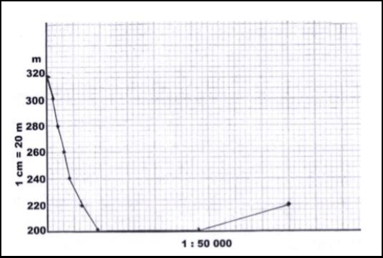
(3 x 1) (3)
2.2.2 Indicate the position of the following on the cross section drawn in QUESTION 2.2.1:
- Secondary road (see graph)
- Rifle range
- Breë River (3 x 1) (3)
2.2.3 Calculate the vertical exaggeration of the cross-section. Show ALL calculations. Marks will be awarded for calculations. (4 x 1) (4)
Formula: ???????? ???????????? = ???????? ?????
?????????? ?????
2.2.4 Would the vertical exaggeration of the cross-section make the interpretation of the landscape easier or difficulty?
Give a reason for your answer.
Answer: (1 x 1) (1)
Reason: (1 x 1) (1)
2.3 Refer to area 6 on the orthophoto map.
2.3.1 Calculate the area of the railway shed 6 on the orthophoto map, in km². Show ALL calculations. Marks will be awarded for calculations. Clearly indicate the unit of measurement in your answer. (5 x 1) (5)
2.3.2 The area 6 on the orthophoto map is the same as the area of railway shed P on the topographical map. Explain why it appears to be smaller on the topographical map. (1 x 1) (1)
[20]
QUESTION 3: APPLICATION AND INTERPRETATION
3.1 Refer to the area in blocks A6 to B8 on the topographical map.
3.1.1 Name the nocturnal (night) wind that occurs between X and Y. (1 x 1) (1)
3.1.2 On the cross-section below, indicate the following:
- Wind direction of the wind named in QUESTION 3.1.1
- Position of Altona
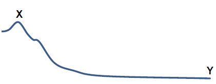
(2 x 1) (2)
3.1.3 Explain how frost will influence the type of crops farmed at Altona. (1 x 2) (2)
3.2 Refer to blocks D4 and E5 on the topographical map.
3.2.1 Name ONE landform of fluvial deposition in blocks D4 and E5. (1 x 1) (1)
3.2.2 Is laminar or turbulent river flow found in blocks D4 and E5? Motivate using evidence to support answer.
Answer:
Evidence: (1 + 1 x 2) (3)
3.3 Worcester enjoys an excellent location as a gap town. With reference to this statement:
3.3.1 Explain the meaning of the term gap town. (1 x 2) (2)
3.3.2 Give TWO map evidences to support the statement that Worcester is a gap town. (2 x 2) (4)
3.4 Refer to 7 on the orthophoto map.
3.4.1 Is the residential area 7 a high- or low-income residential area? Give a reason for your answer.
Answer:
Reason: (1 + 1 x 2) (3)
3.5 Refer to the area demarcated with a white line in the north-east corner on the orthophoto map.
3.5.1 Is the wine cellar / factory at 8 on the orthophoto map market- orientated or raw material-orientated? Give a reason for your answer.
Answer:
Reason: (1 + 1 x 2) (3)
3.5.2 Suggest how the wine cellar / factory in QUESTION 3.5.1 can improve the local economy of Worcester. (2 x 2) (4)
[25]
QUESTION 4: GEOGRAPHICAL INFORMATION SYSTEMS (GIS)
4.1 During a major flooding disaster, accessibility to the Brandvlei Dam in blocks E6 and F6 on topographical map, would be limited. To determine the extent of the damage, remote sensing could be a useful tool.
4.1.1 Give an example of a remote sensing device that can be used to capture the extent of the damage due to flooding. (1 x 1) (1)
4.1.2 Explain how remote sensing could assist in monitoring the environmental impact of flooding in the area. (2 x 2) (4)
4.2 A farmer decides to use data manipulation on his farm situated in blocks G9 and 10.
4.2.1 Explain the term data manipulation. (1 x 1) (1)
4.2.2 Evaluate how data manipulation assists farmers in blocks G9 and 10 to practise sustainable farming methods. (2 x 2) (4)
4.3 The sketch map below is a plan view of the Aan de Doons settlement and its attribute data, located in block F10 and G10.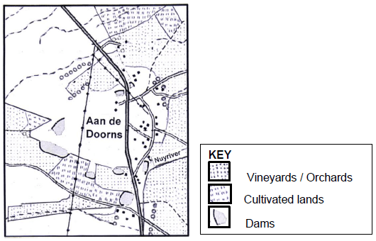
4.3.1 Define the term attribute data. (1 x 1) (1)
4.3.2 Use the symbols (letters of the alphabet) shown in the key below to locate the position of the following attribute data for the Aan de Doons settlement on the sketch map.
- A – Cellar
- B – School (2 x 1) (2)
4.3.3 State TWO attributes of B – School in QUESTION 4.3.2. (2 x 1) (2)
[15]
TOTAL: 75
Geography Paper 1 Grade 12 Questions - NSC Past Papers And Memos September 2020 Preparatory Examinations
INSTRUCTIONS AND INFORMATION
- This question paper consists of four questions.
- Answer any THREE questions of 75 marks each.
- All diagrams are included in the ANNEXURE.
- Number the questions correctly according to the numbering system used in this question paper.
- Leave a line between subsections of questions answered.
- Start EACH question on a NEW page.
- Do NOT write in the margins of the ANSWER BOOK.
- Illustrate your answers with labelled diagrams, where possible.
- he mark allocation is as follows: (2 x 1)
(2) means that TWO facts are required for ONE mark each.
(2 x 2) (4) means that TWO facts are required for TWO marks each. - If words/action verbs like name, identify, provide, classify, are used in a question, ONE word answers are acceptable.
If words/action verbs like discuss, define, explain, comment, evaluate, justify, suggest and substantiate are used in a question, FULL sentences or phrases are required.
All paragraph questions must be answered in FULL sentences. - Write neatly and legibly.
QUESTIONS
SECTION A: CLIMATE, WEATHER AND GEOMORPHOLOGY
QUESTION 1
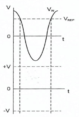
1.1 Refer to FIGURE 1.1 showing winds associated with valley climates. Match the statements below to a wind type (A or B). Write only the letter next to the question numbers (1.1.1–1.1.7) in the ANSWER BOOK.
1.1.1 Can also be described as an upslope wind
1.1.2 Associated with the formation of frost pockets
1.1.3 Carries smoke released by industries into the upper atmosphere
1.1.4 Traps pollutants causing smog
1.1.5 Blows during the day
1.1.6 This wind has a negative impact on settlements on the valley floor
1.1.7 Can also be described as a downslope wind (7 x 1) (7)
1.2 Choose a term from COLUMN B that matches the geology description in COLUMN A. Write only the letter (A–I) next to the question numbers (1.2.1–1.2.8) in the ANSWER BOOK, for example 1.2.9 J.
COLUMN A | COLUMN B | ||
1.2.1 | Area covered by a river and its tributaries | A | watershed |
1.2.2 | Upper limit of water underground | B | episodic |
1.2.3 | Area from where a river draws its water | C | trellis |
1.2.4 | Rivers that only flow after heavy rainfall | D | rectangular |
1.2.5 | Drainage pattern that develops in fold mountains | E | abstraction |
1.2.6 | Drainage pattern that forms on igneous rocks with many joints | F | drainage basin |
1.2.7 | Rivers that originate in areas of high rainfall | G | catchment |
1.2.8 | Process whereby a watershed changes its position | H | exotic |
I | water table | ||
(8 x 1) (8)
1.3 FIGURE 1.3 shows the impact of tropical cyclones on coastal regions.
1.3.1 Name the stage of development of the tropical cyclone depicted by FIGURE 1.3. (1 x 1) (1)
1.3.2 State the main effect of tropical cyclones on coastal regions as evident in photograph A. (1 x 1) (1)
1.3.3 Why would a tropical cyclone dissipate when it reaches land? (2 x 1) (2)
1.3.4 Discuss TWO weather conditions associated with this stage of the tropical cyclone (your answer to QUESTION 1.3.1). (2 x 2) (4)
1.3.5 Refer to sketch B.
- What is a storm surge? (1 x 1) (1)
- Discuss how the dangerous semi-circle (leading left quadrant) would contribute to the formation of storm surges. (1 x 2) (2)
- Explain the negative impact that tropical cyclones would have on tourism in a country. (2 x 2) (4)
1.4 FIGURE 1.4 is a satellite image of line thunderstorms.
1.4.1 What is a moisture front? (1 x 1) (1)
1.4.2 State TWO pieces of evidence on the satellite image that would indicate that line thunderstorms instead of normal thunderstorms are occurring. (2 x 1) (2)
1.4.3 Discuss why more clouds are positioned to the east instead of to the west of the country. (2 x 2) (4)
1.4.4 In a paragraph of approximately EIGHT lines, explain how the location of the anticyclones in summer would promote the formation of line thunderstorms. (4 x 2) (8)
1.5 FIGURE 1.5 shows river rejuvenation.
1.5.1 What is river rejuvenation? (1 x 1) (1)
1.5.2 Give evidence indicating that river rejuvenation has taken place. (2 x 1) (2)
1.5.3 Discuss TWO causes of river rejuvenation. (2 x 2) (4)
1.5.4 Suggest TWO reasons for the abandoned terrace in the sketch. (2 x 2) (4)
1.5.5 Explain the negative impact that a rejuvenated landscape will have on farming activity. (2 x 2) (4)
1.6 Study FIGURE 1.6, photographs (A and B) of river discharge.
1.6.1 What is river discharge? (1 x 1) (1)
1.6.2 Name the types of discharge evident in photographs A and B, respectively. (2 x 1) (2)
1.6.3 Describe the difference in discharge that is evident in photographs A and B. (2 x 1) (2)
1.6.4 Why would the type of river discharge evident in photograph A be more beneficial to farmers? (1 x 2) (2)
1.6.5 In a paragraph of approximately EIGHT lines, discuss how river discharge would influence the different stages/courses of a river. (4 x 2) (8)
[75]
QUESTION 2
2.1 Choose a term in COLUMN B that matches the climatological description in COLUMN A. Write only the letter (A–I) next to the question number (2.1.1–2.1.8) in the ANSWER BOOK, for example 2.1.9 J.
COLUMN A | COLUMN B | ||
2.1.1 | Small, weakly developed cell that moves from the west coast to the east coast | A | polar front |
2.1.2 | Describes descending air that heats by 1 °C every 100 m | B | aspect |
2.1.3 | Zone where tropical westerlies and polar easterlies meet | C | microclimate |
2.1.4 | Anticlockwise movement of air in the northern hemisphere | D | hurricane |
2.1.5 | Associated with clear and stable weather conditions | E | cyclone |
2.1.6 | Study of climate in a small area | F | coastal low |
2.1.7 | Name given to a tropical cyclone in North America | G | typhoon |
2.1.8 | The angle at which the sun’s rays strike the slope | H | DALR |
I | anticyclone | ||
(8 x 1) (8)
2.2 Refer to FIGURE 2.2. Match the statements below with upper, middle, or lower course of the river. Write only the course of the river next to the question numbers (2.2.1–2.2.7) in the ANSWER BOOK.
2.2.1 Valley is V-shaped and steep
2.2.2 Deltas and braided streams are common fluvial landforms
2.2.3 Lateral erosion dominates
2.2.4 Vertical erosion dominates
2.2.5 River and larger streams begin to meander
2.2.6 Temporary base levels of erosion like waterfalls and rapids occur here
2.2.7 This course is associated with a permanent base level of erosion (7 x 1) (7)
2.3 Read the extract in FIGURE 2.3 referring to mid-latitude cyclones.
2.3.1 What is a cold front? (1 x 1) (1)
2.3.2 How do cold fronts form? (1 x 2) (2)
2.3.3 Quote evidence from the passage that suggests that this cold affect the entire country. front will (1 x 2) (2)
2.3.4 Discuss the relationship between cold fronts and very rainy conditions. (1 x 2) (2)
2.3.5 In a paragraph of approximately EIGHT lines, explain the economic impact that snow and heavy rainfall would have on the country.(4 x 2) (8)
2.4 FIGURE 2.4 shows the differences in climate between rural and urban areas.
2.4.1 Name ONE climatic element evident in the sketch that shows the difference between rural and urban areas. (1 x 1) (1)
2.4.2 Why can we describe the condition depicted over the city in the sketch, as a heat island and not a pollution dome? (1 x 2) (2)
2.4.3 Explain how urban activities increase the temperatures in the city. (2 x 2) (4)
2.4.4 Account for the fact that the city receives more rainfall than rural areas even though more evaporation takes place in the rural areas. (2 x 2) (4)
2.4.5 Discuss how the heat island can affect the health of people. (2 x 2) (4)
2.5 FIGURE 2.5 is based on TWO (A and B) fluvial landforms.
2.5.1 What evidence suggests that these two fluvial landforms formed in the lower course of the river? (1 x 1) (1)
2.5.2 Identify the TWO fluvial landforms in sketch A and B. (2 x 1) (2)
2.5.3 How did fluvial landform A develop? (2 x 2) (4)
2.5.4 Discuss the formation of fluvial landform B. (2 x 2) (4)
2.5.5 Explain the impact of fluvial landform B on farming activities. (2 x 2) (4)
2.6 Study FIGURE 2.6 that is based on drainage density.
2.6.1 What is drainage density? (1 x 1) (1)
2.6.2 Classify the drainage density at A and B, into either high or low. (1 x 2) (2)
2.6.3 Discuss how the removal of vegetation will affect the drainage density at A. (2 x 2) (4)
2.6.4 In a paragraph of approximately EIGHT lines, discuss the factors that caused the drainage density at B. (4 x 2) (8)
[75]
SECTION B: RURAL AND URBAN SETTLEMENTS AND SOUTH AFRICAN ECONOMIC GEOGRAPHY
QUESTION 3
3.1 Choose the correct word(s) from those given in brackets. Write only the word(s) next to the question number (3.1.1–3.1.8) in the ANSWER BOOK.
3.1.1 The location of a settlement in relation to the surrounding area is known as (site/situation).
3.1.2 (Expropriation/Restitution) is a land reform policy compensating people for land they lost during apartheid.
3.1.3 Forestry is a dominant economic activity in (rural/urban) settlements.
3.1.4 (Small scale/Large scale) farming occupies large tracts of land and has high yield per hectare.
3.1.5 (‘Brain drain/Bright lights’) is considered an important consequence of people leaving rural areas.
3.1.6 (Site/Situation) is the exact physical landscape on which a settlement is built.
3.1.7 Crossroad settlements can be (semi-circular/star shaped).
3.1.8 (Aids/Soil erosion) is an important social justice issue in rural areas. (8 x 1) (8)
3.2 Various options are provided as possible answers to the following questions. Choose the correct answer and write only the letter (A–D) next to the question numbers (3.2.1–3.2.7) in the ANSWER BOOK, for example 3.2.8 A.
3.2.1 The Saldanha Bay IDZ is focused on the ... sector.
- motor vehicle
- oil and gas
- aluminium
- tourism
3.2.2 ... industries are located between the source of raw material and the customer.
- Footloose
- Market orientated
- Bridge
- Raw material orientated
3.2.3 The platinum SDI industrial region is favoured mostly by access to ...
- minerals.
- skilled labour.
- coalfields.
- harbours.
3.2.4 A sugar mill is an example of a … industry.
- footloose
- ubiquitous
- raw material orientated
- market orientated
3.2.5 The … was a post-apartheid strategy for industrial development that wanted to create jobs and attract foreign investment.
- National Development Plan
- GEAR
- RDP
- Good Hope Plan
3.2.6 The platinum SDI is located in the … Province.
- Gauteng
- North West
- Eastern Cape
- KwaZulu-Natal
3.2.7 Industrial development zones focus primarily on …
- international imports.
- tourism.
- international exports.
- agriculture. (7 x 1) (7)
3.3 FIGURE 3.3 shows a photograph depicting urban blight.
3.3.1 Describe how the photograph depicts urban blight. (1 x 1) (1)
3.3.2 Name TWO causes of urban blight. (2 x 1) (2)
3.3.3 Why is it difficult for local authorities to manage urban blight? (1 x 2) (2)
3.3.4 Discuss how facadism could be used by local authorities to alleviate the effects of urban blight. (1 x 2) (2)
3.3.5 In a paragraph of approximately EIGHT lines, explain the economic importance of urban renewal for urban areas. (4 x 2) (8)
3.4 Refer to FIGURE 3.4, an article on urbanisation of the world population.
3.4.1 What is urbanisation? (1 x 1) (1)
3.4.2 According to the article, how many people live in cities today? (1 x 1) (1)
3.4.3 Quote ONE dynamic (process of change) of urbanisation listed in the article. (1 x 1) (1)
3.4.4 Describe how the process of urban growth can increase the population of urban areas. (1 x 2) (2)
3.4.5 How can urbanisation be associated with the growth of informal settlements? (1 x 2) (2)
3.4.6 Explain why infectious diseases (like the coronavirus) would spread rapidly in South Africa’s informal settlements. (2 x 2) (4)
3.4.7 Discuss the negative economic impact that the increasing rate of urbanisation can have on urban areas. (2 x 2) (4)
3.5 Study the infographic (FIGURE 3.5) on gold mining in South Africa.
3.5.1 State the trend in gold production since 1970. (1 x 1) (1)
3.5.2 According to the passage, what are the negative issues in gold mining? (2 x 1) (2)
3.5.3 Discuss ONE physical (natural) factor that could have been responsible for the trend stated in QUESTION 3.5.1. (1 x 2) (2)
3.5.4 How can ‘digital technology’ have a negative impact on gold mining? (1 x 2) (2)
3.5.5 Discuss possible ways in which mine labourers (workers) can hinder the production of gold in mines. (2 x 2) (4)
3.5.6 Explain some incentives (motivation) that mine owners can introduce to mine labourers (workers) to improve the production of gold in our mines. (2 x 2) (4)
3.6 FIGURE 3.6 is a case study based on the strategies for industrial development: Richards Bay.
3.6.1 In which province is Richards Bay located? (1 x 1) (1)
3.6.2 State from the extract the new investment in Richards Bay. (1 x 1) (1)
3.6.3 Name ONE advantage of this new investment for the people of Richards Bay. (1 x 1) (1)
3.6.4 Discuss what physical (natural) factors made Richards Bay an attractive location for this investment. (2 x 2) (4)
3.6.5 Despite this investment (mentioned in the case study), the local economy still experiences many challenges. In a paragraph of EIGHT lines explain these challenges experienced by the Richards Bay SDI. (4 x 2) (8)
[75]
QUESTION 4
4.1 Various options are provided as possible answers to the following questions. Choose the correct answer and write only the letter (A–D) next to the question numbers (4.1.1–4.1.7) in the ANSWER BOOK, for example 4.1.8 A.
4.1.1 An arrangement of settlements from smallest to largest, according to available functions refers to urban ...
- sprawl.
- expansion.
- hierarchy.
- growth.
4.1.2 The … land use zone has the most accessibility and the highest building density.
- low income residential
- central business district
- rural-urban fringe
- high income residential
4.1.3 A/An ... street plan (pattern) has roads that radiate from a central point.
- unplanned irregular
- grid iron
- planned irregular
- radial
4.1.4 The ... land use model is flexible and resembles many cities in the developed world.
- concentric
- sector
- multiple nuclei
- urbanisation
4.1.5 Minimum number of customers needed to make a business profitable is called the ...
- threshold population.
- range.
- sphere of influence.
- market.
4.1.6 ... towns are urban settlements with one dominant function.
- Junction
- Specialised
- Central place
- Trade of transport
4.1.7 Retail business found along major roads with massive parking space to attract customers are referred to as ... shopping centres.
- outlying business
- planned neighbourhood
- commercial ribbon
- planned regional (7 x 1) (7)
4.2 Choose the correct word(s) from those given in brackets to make each of the statements TRUE. Write only word(s) next to the question numbers (4.2.1–4.2.8) in the ANSWER BOOK.
4.2.1 Balance of (trade/payment) is the difference in value between a country’s imports and exports.
4.2.2 No access to nutritional food for people in a country is known as (food security/food insecurity).
4.2.3 A/An (unfavourable/favourable) balance of trade exists in a country when the value of the exports is greater than the value of imports.
4.2.4 (GDP/GNP) refers to the total value of goods and services produced in a country by the permanent inhabitants in one year.
4.2.5 (Sugar cane/Maize) is mainly farmed in KwaZulu-Natal.
4.2.6 The (primary/secondary) sector makes the greatest contribution to the economy of South Africa.
4.2.7 (Free trade/Protectionism) is most likely to cause local production to decrease and unemployment.
4.2.8 Value added to a raw material by means of processing is called (beneficiation/genetic modification). (8 x 1) (8)
4.3 FIGURE 4.3 is a cartoon on rural depopulation.
4.3.1 Define the term rural depopulation. (1 x 1) (1)
4.3.2 List evidence of rural depopulation mentioned in the cartoon. (2 x 1) (2)
4.3.3 What is so ironic (opposite in meaning) about the purpose of the scarecrow in the cartoon? (1 x 2) (2)
4.3.4 State the lack of TWO basic services that would cause rural depopulation. (2 x 1) (2)
4.3.5 Discuss the social consequences in rural areas as a result of rural depopulation. (2 x 2) (4)
4.3.6 Explain why the policy of land redistribution will only increase rural depopulation. (2 x 2) (4)
4.4 FIGURE 4.4 is a photograph of an urban land-use zone.
4.4.1 What is an urban land-use zone? (1 x 1) (1)
4.4.2 Name the urban land-use zone in the photograph. (1 x 1) (1)
4.4.3 State ONE specialised requirement for this urban land-use zone that is evident in the photograph. (1 x 1) (1)
4.4.4 Discuss why this land-use zone can be considered to be an environmental injustice. (2 x 2) (4)
4.4.5 In a paragraph of approximately EIGHT lines, explain the compatibility between infrastructure and this land-use zone. (4 x 2) (8)
4.5 Refer to FIGURE 4.5, an extract based on the informal sector.
4.5.1 How many people are unemployed, according to the extract? (1 x 1) (1)
4.5.2 Quote evidence to justify that unemployment is a serious problem. (1 x 1) (1)
4.5.3 According to the article, why is the informal sector important? (1 x 1) (1)
4.5.4 Discuss some of the challenges experienced by people in the informal sector. (2 x 2) (4)
4.5.5 In a paragraph of approximately EIGHT lines, explain the negative impact that the informal sector has on the formal sector. (4 x 2) (8)
4.6 FIGURE 4.6 is a map showing the core industrial regions in South Africa.
4.6.1 Name the core industrial region labelled 3. (1 x 1) (1)
4.6.2 What is the main locational difference between industrial regions 1 and 4? (1 x 2) (2)
4.6.3 How has this locational difference (mentioned in QUESTION 4.6.2) influenced the main type of industry that has been developed at 4? (1 x 2) (2)
4.6.4 How has this industry (your answer to QUESTION 4.6.3) improved the skills of workers in the region? (1 x 2) (2)
4.6.5 Discuss the physical (natural) factors that have favoured the development of industrial region 1. (2 x 2) (4)
4.6.6 Explain the negative social impact that industrial centralisation has had at regions 1 and 4. (2 x 2) (4)
[75]
GRAND TOTAL: 225
Electrical Technology: Power Systems Grade 12 Memorandum - NSC Past Papers And Memos September 2020 Preparatory Examinations
INSTRUCTIONS TO MARKERS
- All questions with multiple answers imply that any relevant, acceptable answer should be considered.
- Calculations
2.1 All calculations must show the formulae.
2.2 Substitution of values must be done correctly.
2.3 All answers MUST contain the correct unit to be considered.
2.4 Alternative methods must be considered, provided that the correct answer is obtained.
2.5 Where an incorrect answer could be carried over to the next step, the first answer will be deemed incorrect. However, should the incorrect answer be carried over correctly, the marker has to re-calculate the values, using the incorrect answer from the first calculation. If correctly used, the candidate should receive the full marks for subsequent calculations.
2.6 Markers should consider that candidates’ answers may deviate slightly from the marking a guideline depending on how and where in the calculation rounding off was used. - These marking guidelines are only a guide with model answers.
- Alternative interpretations must be considered and marked on merit. However, this principle should be applied consistently throughout the marking session at ALL marking centres.
MEMORANDUM
QUESTION 1: OCCUPATIONAL HEALTH AND SAFETY
1.1 Accident means an incident arising out of and in the course of an employee’s employment and resulting in a personal injury, illness or the death of the employee. (2)
1.2
- Take reasonable care for the health and safety of him/herself and of other persons who may be affected by his or her action.
- Cooperate with the employer or persons to enable any duties given by the requirements and procedures.
- Carry out any lawful order given to him, and obey the health and safety rules and procedures laid down by his employer or by anyone authorised there by his employer, in the interest of health or safety.
- If any situation which is unsafe or unhealthy comes to his/her attention, as soon as practical report this to his/her employer, or a healthy and safety representative who should report it to the employer. (Any 2) (2)
1.3
- Horseplay
- Running in the workshop
- Throwing things
- Leaving bags, stools or material in the walkway
- Spilling a liquid or oil without cleaning.
- Any relevant answer. (Any 2) (2)
1.4 Third degree burn: where all layers of skin have been burned, causing permanent skin damage affecting fat, muscle and even bone. (2)
1.5
- To review the effectiveness of health and safety measures.
- To identify hazards and potential major incidents at the workplace. (2)
[10]
QUESTION 2: RLC CIRCUIT
2.1
2.1.1 The current and the voltage are out of phase with each other and the current is leading the voltage by 90°. (2)
2.1.2 The current and the voltage are out of phase with each other and the current is lagging the voltage by 90°. (2)
2.1.3 The current and voltage are in phase and their phase angle is zero. (2)
2.2
2.2.1
- ?? = 2???
= 2? × 60 × 44 × 10−3
= 16,587 Ω (3)
2.2.2
- ?? = 1
2???
?? = 1
2?×60×120
?? = 22,105 Ω (3)
2.2.3
- ? = √?2 + (?? − ??)2
= √252 + (22,105 − 16,58)2
? = 25,6 Ω (3)
2.2.4
- ?? = ??
??
= 120
25,6
= 4,69 ? (3)
2.3 The capacitive reactance will decrease because the capacitive reactance is inversely proportional to frequency. (3)
2.4
2.4.1
- ?? = √??2 + (?? − ??)2
= √62 + (5 − 4)2
= 6,08 ? (3)
2.4.2
- ???? = ??
??
? = ???−1 6
6,08
= 9,305° (3)
2.4.3
- ?? = ??
??
?? = 240
5
?? = 48 Ω (3)
2.4.4
- ?? = ??
??
?? = 240
4
= 60 Ω (3)
2.5
2.5.1
- ?? = 1
2?√??
?? = 1
2?√0,2×0,05−6
?? = 1 591,5 ?? (3)
2.5.2
- ?? = 2???
?? = 2? × 1 591,5 × 0,2
?? = 1 999,938 Ω
? = ??
?
? = 1999,938
10
? = 200 (4)
2.5.3
- ?? = ??
?
?? = 1591,5
200
= 7,958 Hz (3)
2.6
2.6.1
- ? = ??
??
? = 95×106
200×103
Q = 475 Hz (3)
2.6.2
- ?? = 1
2???
?? = 1
2?×95×106×2,5×106
?? = 22,105 Ω (2)
2.6.3
- ? = ??
?
? = 670
475
= 1,4466 Ω (2)
[50]
QUESTION 3: THREE-PHASE AC GENERATION
3.1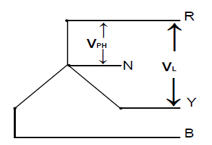
Diagram correctly drawn
VPH
VL
Phasors labelled correctly (4)
3.2.
3.2.1 It is a device that measures the amount of electrical energy consumed over a certain time. (2)
3.2.2 A device that measures the power consumed by an application. (1)
3.3
- Cannot be distributed economically over long distances.
- Not suitable for heavy duty applications requiring large amounts of power.
- Uses larger currents and hence thicker cables.
- For an equivalent application it is not as economical as three-phase. (2)
3.4.
3.4.1
- The current coils of the two wattmeters are connected in series to the red and blue phases.
- The voltage coils of the two wattmeters are connected to each other and to the yellow phase (3)
3.4.2
- PT = W1 + W2
= 5 000 + 7 500
= 12 500 W = 12,5 kW (3)
3.4.3
 (5)
(5)
3.5
3.5.1
- V = VL
√3
= 380
√3
= 219,39 V (3)
3.5.2
- P = √3VLIL cos θ
IL = P
√3VL cos θ
= 25000
√3×380×0,8
= 47,48A (3)
3.5.3
- ? = √3VLIL sin θ θ = cos−1 0,8
= √3 × 380 × 47,48 × sin(cos−1 0,8)
= 18 750,21 VAr = 18,75 kVAr (3)
3.6 Delta is a three-phase, three wire supply and dwellings need a neutral point to supply a single-phase voltage of 220 V. (2)
3.7 A low power factor causes lagging currents. This causes a higher current flow for a given load. As the line current increases, the voltage drop in the conductor increases, which may result in a lower voltage at the equipment. (4)
3.8.1
- Electricity is generated in power stations by converting natural gases, coal, fossil fuel, nuclear fuel and water action into electrical energy.
- Basic fuels heat steam to drive turbines which drive huge generators. (2)
3.8.2
- The generate electricity is stepped up to a high voltage and then fed to a national grid.
- From the national grid it is transmitted with overhead power lines to different power stations. (2)
3.8.3
- Commercial buildings
- Dwellings
- Industries
- Government buildings
- Any other relevant answer (1)
[40]
QUESTION 4: THREE-PHASE TRANSFORMERS
4.1
- Core-type
- Shell-type (2)
4.2 The mineral oil insulates and cools the windings. (2)
4.3
- Inverse definite minimum time relay
- Instantaneous overcurrent relay
- Balanced earth fault relay
- Buchholtz relay (Any 2) (2)
4.4
- Oil Natural, Air Natural
- Oil Natural. Air Forced
- Oil forced, Air Forced
- Oil Forced, Water Forced (Any 2) (2)
4.5 Mutual induction (1)
4.6.
4.6.1
- S = √3VLSILS
ILS = S
√3VLS
= 20 000
√3×500
= 23,09 A (3)
4.6.2
- VLP = VPHP = 6 000 V
VPHS = VLS
√3
= 500
√3
= 288,68 V
T. Ratio = VPHP
VPHS
= 6000
288,68
= 20,78 ∶ 1 (6)
4.6.3
- ?????? = ? cos ?
= 20 000 × 0,88 OR
= 17 600 ? = 17,6 ??
OR
?????? = √3???? cos ?
= √3 × 500 × 23,09 × 0,88
= 17596,94 ? = 17,6 ?? (3)
4.6.4
- ŋ = ??????−??????? × 100
??????
= 20 000 − 160 × 100
20 000
= 99,2% (3)
4.7 Transformers have no moving parts as a result fewer losses develop, and it delivers a better power output. Transformers have a more efficient design. (3)
4.8 A transformer has no moving parts for induction to take place. Unlike DC- current, the AC-current produces an alternating flux which expands and collapses to produce the movement of the magnetic field that is required for induction. (3)
[30]
QUESTION 5: THREE-PHASE MOTORS AND STARTERS
5.1 Slip is the difference between the rotor speed and the rotating magnetic field of the stator. (2)
5.2
- To reduce magnetic humming
- To avoid cogging
- Increase in effective ratio of transformation between stator and rotor
- Increase slip for a given torque (Any 2) (2)
5.3.
5.3.1 To ensure that the insulation of the windings is not damaged and touching the frame of the motor. (2)
5.3.2 Reading must be at least 1 MΩ (1)
5.4 To reduce the starting voltage of the motor windings (1)
5.5.
5.5.1 Three-phase forward reverse starter (1)
5.5.2 They are electrical interlocking contacts that prevent both contactors being energised at the same time. (2)
5.5.3 The forward contactor is energised. The N/O F contactor closes, keeping the forward contactor energised after the start forward button is released. At the same time the N/C F opens thus preventing the reverse contactor from being energised until the stop button is pressed. (4)
5.5.4 To automatically disconnect the motor from the supply in the event of excessive currents flowing. (2)
5.5.5 When the circuit is energised the reverse contactor would be energised and the motor would run in reverse. When the stop button is pressed the motor would run in reverse as soon as the stop button is released. The motor will not be able to run in the forward direction. (4)
5.6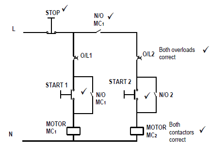 (6)
(6)
5.7
- VL = VPH = 380 VN
PINPUT = √3VLIL cos θ
= √3 × 380 × 25 × 0,866
= 14 249,58 W = 14,25 kW (3)
5.8 The velocity of the rotating magnetic field in the stator windings. (2)
5.9
- Slip = ns−nr × 100
ns
= 1 200 −1 140 × 100
1 200
= 5% (3)
5.10
- Supply voltage
- Frequency
- Speed
- Rated current
- Output power
- Power factor (Any 2) (3)
5.11 No, the rated frequency and voltage are not suitable for South Africa which uses 380 V / 50 Hz. (2)
[40]
QUESTION 6: PROGRAMMABLE LOGIC CONTROLLERS
6.1 6.1.1 D (1)
6.1.2 C (1)
6.1.3 A (1)
6.1.4 E (1)
6.1.5 B (1)
6.2 Software is installed to provide data and instructions to a computer or PLC’s control program, to allow it to interact with its input hardware, to achieve a desired output. (3)
6.3
6.3.1  (3)
(3)
6.3.2 (3)
(3)
6.4 It is a semiconductor device that uses light to transfer an electrical signal between circuits or elements of a circuit while keeping them electrically isolated from each other. (3)
6.5
- Safety or security devices (light beams as a switch for garage door)
- Control the brightness of screens of electronic devices (TV’s, computers, phones).
- Switches lights on automatically. (Any 2) (2)
6.6 The timer is used to provide an ‘ON’ or an ‘OFF’ delay in the operation of a PLC’s logic program. (2)
6.7 (9)
(9)
[30]
TOTAL: 200
Electrical Technology: Power Systems Grade 12 Questions - NSC Past Papers And Memos September 2020 Preparatory Examinations
INSTRUCTIONS AND INFORMATION
- This question paper consists of SIX questions.
- Answer ALL the questions.
- Show ALL calculations and round off answers correctly to TWO decimal places.
- Number the answers correctly according to the numbering system used in this question paper.
- Sketches and diagrams must be large, neat and FULLY LABELLED.
- You may use a non-programmable calculator.
- Calculations must include:
7.1 Formulae and manipulations where needed
7.2 Correct replacement of values
7.3 Correct answers and relevant units where applicable - A formula sheet is provided at the end of this question paper.
- Write neatly and legibly.
QUESTIONS
QUESTION 1: OCCUPATIONAL HEALTH AND SAFETY
1.1 Define the term accident with reference to the Occupational Health and Safety Act, 1993 (Act 85 of 1993). (2)
1.2 Explain TWO general duties of employees in the workplace. (2)
1.3 State TWO unsafe conditions in a school workshop that can cause an accident. (2)
1.4 Briefly explain a third-degree burn. (2)
1.5 State TWO functions of a health and safety representative. (2)
[10]
QUESTION 2: RLC
2.1 Explain the phase relationship between current and voltage in the following AC circuit:
2.1.1 A pure capacitive circuit (2)
2.1.2 A pure inductive circuit (2)
2.1.3 A resistive circuit (2)
2.2 Refer to the circuit diagram FIGURE 2.2 below and answer the questions that follow.
FIGURE 2.2: RLC CIRCUIT
Calculate the:
2.2.1 Inductive reactance (3)
2.2.2 Capacitive reactance (3)
2.2.3 Impedance of the circuit (3)
2.2.4 Total current flow through the circuit (3)
2.3 Explain how the value of the capacitive reactance will be affected if the supply frequency is increased. (3)
2.4 A parallel circuit in FIGURE 2.5 consists of a capacitor that draws a current of 4 A, an inductor that draws a current of 6 A and a resistor that draws a current of 5 A. All the components are connected to 240 V / 50 Hz supply.
FIGURE 2.5: RLC PARALLEL CIRCUIT
Calculate:
2.4.1 The total current through the circuit (3)
2.4.2 The phase angle (3)
2.4.3 The inductive reactance (3)
2.4.4 The capacitive reactance (3)
2.5 A parallel RLC circuit consists of a 10 Ω resistor and a 0,05 µF and a 0,2 H inductor connected across a 120 V supply. Calculate the:
2.5.1 Resonant frequency (3)
2.5.2 Q-factor (4)
2.5.3 Bandwidth (3)
2.6 A series RLC tuned circuit has a resonant frequency of 95 MHz and a bandwidth of 200 kHz. The capacitor is 2,5 pF and the wire used to wind the coil has zero resistance. Calculate:
2.6.1 The Q factor of the circuit (3)
2.6.2 The size of the inductor (2)
2.6.3 The circuit resistance (2)
[50]
QUESTION 3: THREE-PHASE AC GENERATION
3.1 Draw a neat, labelled schematic representation of a star connected power system. Show all voltages and phasors. (4)
3.2 State the functions of the following meters:
3.2.1 Kilowatt-hour meter (2)
3.2.2 Wattmeter (1)
3.3 Name TWO disadvantages of a single-phase system when compared to a three-phase system. (2)
3.4 Refer to FIGURE 3.4 below and answer the questions that follow.
FIGURE 3.4
3.4.1 Describe how the two watt meters are connected to the star system. (3)
3.4.2 Calculate the total power of the three-phase system. (3)
3.4.3 Calculate the power factor of the system. (5)
3.5 A 380 V three-phase system is star connected to a lagging load. The input power is 25 kW and the load causes a lagging power factor of 0,8.
Given :
- VL = 380 V
- PIN = 25 kW
- cos θ = 0,8
Calculate:
3.5.1 The phase voltage (3)
3.5.2 The line current to the load (3)
3.5.3 The reactive power (3)
3.6 Explain why the power supply to dwellings cannot be connected in delta. (2)
3.7 Describe how a low power factor affects an AC electrical power system. (4)
3.8 Discuss the following stages of three-phase AC generation from the supplier to the consumer.
3.8.1 Generation (2)
3.8.2 Transmission (2)
3.8.3 Mention ONE type of consumer that receives electricity from intermediate substations. (1)
[40]
QUESTION 4: THREE-PHASE TRANSFORMERS
4.1 Name TWO types of transformer configurations available when manufacturing three-phase transformers. (2)
4.2 Mention the reasons for mounting the magnetic circuit and windings of power transformers in mineral oil. (2)
4.3 Mention TWO types of protection devices used for the protection of transformers. (2)
4.4 State TWO cooling methods used for oil-immersed transformers. (2)
4.5 Name the type of induction that takes place between the primary and secondary coils of a transformer. (1)
4.6 A 20 kVA delta-star transformer has a primary voltage of 6 kV and a secondary voltage of 1 000 V. The losses amount to 160 W and the power factor is 0,88.
Given:
- S = 20 kVA
- VLP = 6 kV
- VLS = 500 V
- PLOSSES = 160 W
- cos θ = 0,88
Calculate:
4.6.1 The secondary line current (3)
4.6.2 The transformation ratio (6)
4.6.3 The input power (3)
4.6.4 The efficiency of the transformer (3)
4.7 Explain why transformers have a better efficiency than motors. (3)
4.8 Explain why a transformer only operates with an AC supply. (3)
[30]
QUESTION 5: THREE-PHASE MOTORS AND STARTERS
5.1 Define the term slip with reference to a three-phase AC induction motor. (2)
5.2 Give TWO reasons why the rotor of an induction motor is skewed. (2)
5.3 One of the electrical tests performed on the stator of a three-phase motor is the insulation resistance test between windings and earth.
5.3.1 State the reasons for performing this test. (2)
5.3.2 Write down the accepted value for a motor to pass this test. (1)
5.4 State the main function of a three-phase motor starter. (1)
5.5 Refer to the control circuit in FIGURE 5.5 and answer the questions that follow.
FIGURE 5.5: CONTROL CIRCUIT
5.5.1 Identify the starter shown in FIGURE 5.5. (1)
5.5.2 Describe the function of the two normally closed contacts in the circuit. (2)
5.5.3 Explain what happens if the circuit is energised and the start forward button is pressed. (4)
5.5.4 Describe the function of the overload contact in the circuit. (2)
5.5.5 Explain how a faulty N/O R that remains stuck in the closed position, would affect the operation of the starter. (4)
5.6 A manual sequence starter has the following sequence:
- Motor 1 must start before Motor 2
- Each motor must have independent overload protection
- A stop button controls both motors
Draw the control circuit of the sequence starter. (6)
5.7 A delta connected three-phase motor has a phase voltage of 380 V with a power factor of 0,866. The line current is 25 A when the motor is connected to the supply. Calculate the input power to the motor.
Given:
- VPH = 380 V
- cos θ = 0,866
- IL = 25 A (3)
5.8 Define the term synchronous speed of a motor. (2)
5.9 A three-phase motor with 24 poles has a synchronous speed of 1 200 rpm. Determine the percentage slip if the rotor speed is 1 140 rpm.
Given:
- Poles = 24
- NS = 1 200 rpm
- NP = 1 140 rpm (3)
5.10 Mention THREE types of information that can be found on the nameplate of a motor. (3)
5.11 A 110 V / 60 Hz three-phase motor is connected to a supply in a factory in South Africa. State with a reason if the motor will operate. (2)
[40]
QUESTION 6: PROGRAMMABLE LOGIC CONTROLLERS (PLC’s)
6.1 Choose a description from COLUMN B that matches with the term in COLUMN A. Write only the letter (A–E) in COLUMN B next to the question number (6.1.1–6.1.5) in COLUMN A, for example 6.1.6 G.
COLUMN A | COLUMN B | ||
6.1.1 | Input device | A | Brain of the PLC |
6.1.2 | Hardware | B | Disadvantage of hardwiring |
6.1.3 | Processor | C | Physical parts and components |
6.1.4 | Output | D | Sensor |
6.1.5 | Bulky | E | Motor |
(5 x 1) (5)
6.2 Explain why software is installed. (3)
6.3 Refer to FIGURE 6.3 below and answer the questions that follow.
INPUT A | INPUT B | OUTPUT (F) |
0 | 0 | 1 |
0 | 1 | 0 |
1 | 0 | 0 |
1 | 1 | 0 |
FIGURE 6.3: TRUTH TABLE
6.3.1 Draw the ladder diagram that this truth table represents. (3)
6.3.2 Draw the logic gate symbol that this truth table represents. (3)
6.4 Define an opto-isolator. (3)
6.5 State TWO applications of light sensors. (2)
6.6 Describe the function of the timer used in PLC programs. (2)
6.7 Refer to FIGURE 6.7 and draw a logic ladder diagram that executes the same function as the one in FIGURE 6.7.
FIGURE 6.7
NOTE: The circuit is energised. (9)
[30]
TOTAL: 200
FORMULA SHEET
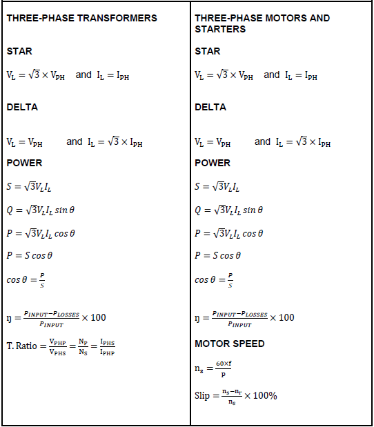
Electrical Technology: Electronics Grade 12 Questions - NSC Past Papers And Memos September 2020 Preparatory Examinations
INSTRUCTIONS AND INFORMATION
- This question paper consists of FIVE questions.
- Answer ALL the questions.
- Answer the following questions on the attached ANSWER SHEETS:
QUESTION 4.4.1
QUESTION 4.5.4
QUESTION 4.6.2 - Write your FULL NAME and CLASS SECTION on every ANSWER SHEET and hand them in with your ANSWER BOOK, whether you have used them or not.
- Sketches and diagrams must be large, neat and FULLY LABELLED.
- Show ALL calculations and round off answers correctly to TWO decimal places.
- Number the answers correctly according to the numbering system used in this question paper.
- You may use a non-programmable calculator.
- Calculations must include:
9.1 Formulae and manipulations where needed
9.2 Correct replacement of values
9.3 Correct answer and relevant units where applicable - A formula sheet is attached at the end of this question paper.
- Write neatly and legibly.
QUESTIONS
QUESTION 1: OCCUPATIONAL HEALTH AND SAFETY
1.1 Define the term accident, with reference to the Occupational Health and Safety Act, 1993 (Act 85 of 1993). (2)
1.2 Explain TWO general duties of employees in the workplace. (2)
1.3 Give TWO unsafe acts in a school workshop that can cause an accident. (2)
1.4 Briefly explain a third-degree burn. (2)
1.5 State TWO functions of a health and safety representative. (2)
[10]
QUESTION 2: RLC
2.1 Explain the phase relationship between current and voltage in the following AC circuit:
2.1.1 Pure capacitive circuit (2)
2.1.2 Pure inductive circuit (2)
2.1.3 Resistive circuit (2)
2.2 Refer to the circuit diagram FIGURE 2.2 below and answer the questions that follow.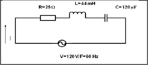
FIGURE 2.2: RLC CIRCUIT
Calculate:
2.2.1 Inductive reactance (3)
2.2.2 Capacitive reactance (3)
2.2.3 Impedance of the circuit (3)
2.2.4 Total current flow through the circuit (3)
2.3 Explain how the value of the capacitive reactance will be affected if the supply frequency is increased. (3)
2.4 A parallel circuit in FIGURE 2.4 consists of a capacitor that draws a current of 4 A, an inductor that draws a current of 6 A and a resistor that draws a current of 5 A. All the components are connected to a 240 V / 50 Hz supply.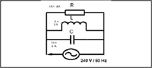
FIGURE 2.4: RLC PARALLEL CIRCUIT
Calculate:
2.4.1 Total current through the circuit (3)
2.4.2 The phase angle (3)
2.4.3 Inductive reactance (3)
2.4.4 Capacitive reactance (3)
2.5 A parallel RLC circuit consists of a 10 Ω resistor, a 0,05 µF and a 0,2 H inductor connected across a 120 V supply. Calculate the:
2.5.1 Resonant frequency (3)
2.5.2 Q-factor (4)
2.5.3 Bandwidth (3)
2.6 A series RLC tuned circuit has a resonant frequency of 95 MHz and a bandwidth of 200 kHz. The capacitor is 2,5 pF and the wire used to wind the coil has zero resistance. Calculate:
2.6.1 The Q factor of the circuit (3)
2.6.2 The size of the inductor (2)
2.6.3 The circuit resistance (2)
[50]
QUESTION 3: SEMICONDUCTORS
3.1 Explain the purpose of a field effect transistor. (2)
3.2 State the main advantage of field-effect devices over bipolar junction devices. (4)
3.3 Draw and label a symbol for the P-channel enhancement MOSFET. (3)
3.4 State TWO applications of an unijunctiontransistor (UJT). (2)
3.5 List THREE ideal properties of an ideal Op Amp. (3)
3.6 Describe the differences between the inverting and non-inverting inputs of an Op amp. (2)
3.7 Draw and label the symbol of a Darlington pair transistor. (4)
3.8 Explain the advantage of using negative feedback with an Op amp. (3)
3.9 Refer to FIGURE 3.9 and calculate the gain of the amplifier if the feedback resistor has a value of 120 kΩ and input resistor has a value of 12 kΩ.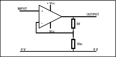
FIGURE 3.9: NON-INVERTING AMPLIFIER (3)
3.10 Refer to FIGURE 3.10 below and answer the questions that follow.
FIGURE 3.10: INVERTING OP-AMP
3.10.1 Calculate the gain of the Op amp. (3)
3.10.2 Calculate the output voltage. (3)
3.11 Explain the purpose of the comparator. (2)
3.12 List THREE modes of operation of a 555 timer IC. (3)
3.13 Explain the purpose of the THREE internally connected series resistor in a 555 IC. (3)
[40]
QUESTION 4: SWITCHING CIRCUITS
4.1 Explain the purpose of an astable multivibrator. (2)
4.2 Draw a fully labelled circuit diagram of a 741 astable multivibrator circuit. (5)
4.3 Refer to FIGURE 4.3 below and answer the questions that follow.
FIGURE 4.3: BISTABLE MULTIVIBRATOR
4.3.1 State the function of R1 and R2. (2)
4.3.2 Describe what happens when the set switch, S1 is pressed. (3)
4.3.3 Explain why threshold pin 6 is connected directly to ground. (3)
4.4 FIGURE 4.4 below shows input trigger pulses A and B to a 555 mono- stable multivibrator. Answer the questions that follow.
FIGURE 4.4: MONOSTABLE MULTIVIBRATOR TRIGGER PULSE
4.4.1 Draw the output signal on ANSWER SHEET 4.4.1. (4)
4.4.2 Describe the condition that occurred at trigger pulse B. (2)
4.4.3 Explain why the condition that occured at trigger pulse B does NOT affect the capacitor charging. (3)
4.5 Refer to FIGURE 4.5.1 below and answer the questions that follow.
FIGURE 4.5.1: SCHMITT TRIGGER INPUT AND OUTPUT
4.5.1 State whether the output signal represents an inverting or non- inverting Schmitt trigger. Motivate your answer. (3)
4.5.2 Draw the circuit diagram of a Schmitt trigger consisting of TWO resistors and a 741 op-amp that will produce the output signal in FIGURE 4.5.1. (7)
4.5.3 Name TWO transducers that can be used as input devices to the Schmitt trigger. (2)
4.5.4 Draw the output signal on ANSWER SHEET 4.5.4 if the input signal in FIGURE 4.5.4 below is applied to the circuit.
FIGURE 4.5.4: INPUT SIGNAL (4)
4.6 Refer to FIGURE 4.6 below and answer the questions that follow.
FIGURE 4.6: OP-AMP CIRCUIT DIAGRAM
4.6.1 Identify the op-amp circuit diagram in FIGURE 4.6. (2)
4.6.2 Draw the output signal on the ANSWER SHEET for QUESTION 4.6.2. (4)
4.6.3 Explain how the reference voltage is made negative. (2)
4.7 Refer to FIGURE 4.7 below and answer the questions that follow.
FIGURE 4.7: INVERTING SUMMING AMPLIFIER
Given:
- V1 = 300 mV
- V2 = 500 mV
- V3 = 400 mV
- RF = 100 kΩ
- R1 = R2 = R3 = 20 kΩ
4.7.1 Explain how the gain of this amplifier can be determined. (3)
4.7.2 Calculate the output voltage of the amplifier. (3)
4.7.3 Give a reason why the amplifier is NOT saturated. (2)
4.7.4 Calculate the gain of the amplifier using voltage values. (3)
4.7.5 Describe what will happen to the output voltage if the value of R2 is changed to 10 kΩ. (1)
[60]
QUESTION 5: AMPLIFIERS
5.1 Refer to FIGURE 5.1 below and answer the following questions.
FIGURE 5.1
Calculate:
5.1.1 The voltage across the resistor (VCE) (2)
5.1.2 The maximum current (3)
5.2 Explain TWO advantages of class AB amplifiers. (2)
5.3 A 741 operational amplifier has an open loop gain of 100. It is connected into a negative feedback circuit which feeds back 9% of the output signal.
Answer the following questions.
5.3.1 Draw the circuit diagram of a negative feedback. (5)
5.3.2 Name THREE advantages of negative feedback (3)
5.3.3 Calculate the overall gain of negative feedback. (3)
5.4 State TWO advantages of a transformer coupled amplifier. (2)
5.5 List TWO uses for RF amplifiers. (2)
5.6 State TWO advantages of a push pull amplifier. (2)
5.7 Refer to an RC-phase shift oscillator and answer the following questions.
5.7.1 Write down the formula to calculate the resonant frequency of a phase shift oscillator. (2)
5.7.2 Draw a circuit diagram of a RC phase shift oscillator. (6)
5.7.3 State TWO advantages of the RC network. (2)
5.7.4 Explain the type of feedback used by the RC phase shift oscillator. (3)
5.7.5 List THREE important areas on a frequency response curve. (3)
[40]
TOTAL: 200
FORMULA SHEET: ELECTRICAL TECHNOLOGY

ANSWER SHEETS
ANSWER SHEET 4.4.1
ANSWER SHEET 4.5.4 
ANSWER SHEET 4.6.2