
Adele
PHYSICAL SCIENCES PAPER 1 GRADE 12 MEMORANDUM - NSC EXAMS PAST PAPERS AND MEMOS JUNE 2019
PHYSICAL SCIENCES
PAPER 1
GRADE 12
NSC EXAMS
PAST PAPERS AND MEMOS JUNE 2019
GENERAL GUIDELINES
- CALCULATIONS
1.1 Marks will be awarded for: correct formula, correct substitution, correct answer with unit.
1.2 No marks will be awarded if an incorrect or inappropriate formula is used, even though there are many relevant symbols and applicable substitutions.
1.3 When an error is made during substitution into a correct formula, a mark will be awarded for the correct formula and for the correct substitutions, but no further marks will be given.
1.4 If no formula is given, but all substitutions are correct, a candidate will forfeit one mark.
1.5 No penalisation if zero substitutions are omitted in calculations where correct formula/principle is correctly given.
1.6 Mathematical manipulations and change of subject of appropriate formulae carry no marks, but if a candidate starts off with the correct formula and then changes the subject of the formula incorrectly, marks will be awarded for the formula and correct substitutions. The mark for the incorrect numerical answer is forfeited.
1.7 Marks are only awarded for a formula if a calculation has been attempted, i.e. substitutions have been made or a numerical answer given.
1.8 Marks can only be allocated for substitutions when values are substituted into formulae and not when listed before a calculation starts.
1.9 All calculations, when not specified in the question, must be done to a minimum of two decimal places.
1.10 If a final answer to a calculation is correct, full marks will not automatically be awarded. Markers will always ensure that the correct/appropriate formula is used and that workings, including substitutions, are correct.
1.11 Questions where a series of calculations have to be made (e.g. a circuit diagram question) do not necessarily always have to follow the same order. FULL MARKS will be awarded provided it is a valid solution to the problem. However, any calculation that will not bring the candidate closer to the answer than the original data, will no count any marks. - UNITS
2.1 Candidates will only be penalised once for the repeated use of an incorrect unit within a question.
2.2 Units are only required in the final answer to a calculation.
2.3 Marks are only awarded for an answer, and not for a unit per se. Candidates will therefore forfeit the mark allocated for the answer in each of the following situations:- Correct answer + wrong unit
- Wrong answer + correct unit
- Correct answer + no unit
2.4 SI units must be used except in certain cases, e.g. V.m-1 instead of N.C-1, and cm.s-1 or km.h-1 instead of m.s-1 where the question warrants this.
- GENERAL
3.1 If one answer or calculation is required, but two are given by the candidate, only the first one will be marked, irrespective of which one is correct. If two answers are required, only the first two will be marked, etc.
3.2 For marking purposes, alternative symbols (s, u, t etc) will also be accepted.
3.3 Separate compound units with a multiplication dot, no a full stop, for example, m.s-1. For marking purposes, m.s-1 and m/s will also be accepted. - POSITIVE MARKING
Positive marking regarding calculations will be followed in the following cases: Positiewe nasien met betrekking tot berekeninge sal in die volgende gevalle geld:
4.1 Subquestion to subquestion: When a certain variable is calculated in one subquestion (e.g. 3.1) and needs to be substituted in another (3.2 of 3.3), e.g. if the answer for 3.1 is incorrect and is substituted correctly in 3.2 or 3.3, full marks are to be awarded for the subsequent subquestions.
4.2 A multistep question in a subquestion: If the candidate has to calculate, for example, current in die first step and gets it wrong due to a substitution error, the mark for the substitution and the final answer will be forfeited. - NEGATIVE MARKING
Normally an incorrect answer cannot be correctly motivated if based on a conceptual mistake. If the candidate is therefore required to motivate in QUESTION 3.2 the answer given in QUESTION 3.1, and 3.1 is incorrect, no marks can be awarded for QUESTION 3.2. However, if the answer for e.g. 3.1 is based on a calculation, the motivation for the incorrect answer could be considered
MEMORANDUM
QUESTION 1
1.1 C ✔✔ (2)
1.2 A ✔✔ (2)
1.3 B ✔✔ (2)
1.4 D ✔✔ (2)
1.5 C ✔✔ (2)
1.6 A ✔✔ (2)
1.7 B ✔✔ (2)
1.8 D ✔✔ (2)
1.9 A ✔✔ (2)
1.10 A ✔✔ (2) [20]
QUESTION 2
2.1 When a net force/resultant force acts on an object, it produces the acceleration of the object in the direction of the net force/resultant force. This acceleration is directly proportional to the net/resultant force ✔ and inversely proportional to the mass of the object. ✔ (2)
2.2
| OTPION 1 | OPTION 2 |
 | |
Mark awarded for both arrow and label.
Do not penalise for length of forces since drawing is not drawn to scale.
Any other additional force(s)
If force(s) do not make contact with body. Max. (5)
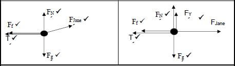
2.3 Choose East (Right) to be positive
4 kg box
- Fnet = ma
Fx + fk + T = ma
Fx - fk - T = ma
FJaneCos30° + fk + T = ma
80x0,866 + (-8,14) + (-T) = 4a
69,28 - 8,14 - T = 4a
61,14 - T = 4a -------- (1)
5 kg box
- Fnet = ma
T + W = ma
T + (-9,8x5) = 5a
T - 49 = 5a
a = T- 49 ------(2)
5
Subst (2) in (1):(2) in (1):
61,14 - T = 4[T- 49]
[ 5 ]
305,7 - 5 T = 4 T - 196
9 T = 501,7
T = 55,74 N (5) [12]
QUESTION 3
3.1 Each body in the universe attracts every other body with a force that is directly proportional to the product of their masses and inversely proportional to the square of the distance between their centres. (2)
3.2
| OPTION 1 | OPTION 2 |
| f = Gm1m2 r2 126,30 = 6,67 × 10-11 × 7,35 × 1022m2 (1,74 × 10⁶)2 m2 = 78,00 kg | gm = GMm Rm = 6,67 × 10-11 × 7,35 × 1022 (1,74 × 10⁴)2 = 1,619252874 w = mg 126,30 = m × 1,619252874 m = 78,00 kg |
(4) [6]
QUESTION 4
4.1 Projectile motion is the motion of an object upon which the only force acting is the force of gravity.
OR
Projectile motion is the motion of an object that experiences only gravitational force.(2)
4.2 (3)
| OPTION 1 | |
| (upwards positive) | (downwards positive) |
| vf = vi + g∆t 0 = (13) + (-9.8 ). ∆t ∆t = 1,33 s | vf = vi + g∆t 0 =(-13) + (9.8) .∆t ∴ ∆t = 1,33 s |
| OPTION 2 | |
| (upwards positive) | (downwards positive) |
| vf2 = vi2 + 2a∆y 02 = 132 + 2 (-9,8) ∆y ∆y = 8,62244898 m ∆y = vf + vi ∆t 2 8,62244898 = 0 + 13 ∆t 2 ∴ ∆t = 1,33 s | vf2 = vi2 + 2a∆y 02 = 132 + 2 (9,8) ∆y ∆y = 8,62244898 m ∆y = vf + vi ∆t 2 8,62244898 = 0 - 13 ∆t 2 ∴ ∆t = 1,33 s |
| OPTION 3 | |
| (upwards positive) | (downwards positive) |
| vf2 = vi2 + 2g∆y 02 = 132 + 2 (-9,8) ∆y ∆y = 8,62244898 m ∆y = vi∆t + 1 g∆t2 2 8,62 = 13 ∆t + 1 (- 9,8) ∆t2 2 ∆t = 1,33 s (3) | vf2 = vi2 + 2g∆y 02 = 132 + 2 (9,8) ∆y ∆y = 8,62244898 m ∆y = vi∆t + 1 g∆t2 2 8,62 = 13 ∆t + 1 (9,8) ∆t2 2 ∆t = 1,33 s (3) |
4.3 (4)
| OPTION 1 | |
| (upwards positive) | (downwards positive) |
| vf 2 = vi2 +2 g∆y 02 = (13)2 + 2 (-9,8) ∆y ∆y = 8,62 m | vf 2 = vi2 +2 g∆y 02 = (-13)2 + 2 (-9,8) ∆y ∆y = 8,62 m |
OPTION 2 | |
(upwards positive) | (downwards positive) |
∆y = vi∆t + 1 g∆t2 | ∆y = vi∆t + 1 g∆t2 = -13(1,33) + 1 (9,8)(1,33)2 |
| OPTION 3 | |
| (upwards positive) | (downwards positive) |
| ∆y = vf + vi ∆t 2 = 0 + 13 × 1,33 2 = 8,65 m | ∆y = vf + vi ∆t 2 = 0 - 13 × 1,33 2 = - 8,65 m = 8,65 m |
4.4
4.4.1
| OPTION 1 | |
| Taking top of building as starting point | |
| (upwards positive) | (downwards positive) |
vf = vi + a∆t | vf = vi + a∆t vf = 0 + (-9,8)(3,28 - 1,33) vf = 19,11 m.s-1 |
| OPTION 1 | |
| Taking balcony as a starting point | |
| (upwards positive) | (downwards positive) |
| vf = vi + a∆t vf = -13 + (-9,8)(3,28 - 1,66) vf = -19,08 m.s-1 vf = 19,08 m.s-1 (3) | vf = vi + a∆t vf = -13 + (-9,8)(3,28 - 1,66) vf = 19,08 m.s-1 (3) |
4.4.2
| OPTION 1 | |
| (upwards positive) | (downwards positive) |
| ∆y = h = vi∆t + 1 a∆t2 2 h = -13(0,62) + 1 (-9,8)(0,62)2 2 h = - 9,94 m Height of building = h + ∆y = 8,62 + 9,94 = 18,56 m | ∆y = h = vi∆t + 1 a∆t2 2 h = 13(0,62) + 1 (9,8)(0,62)2 2 h = - 9,94 m Height of building = h + ∆y = 8,62 + 9,94 = 18,56 m |
OPTION 2 | |
(upwards positive) | (downwards positive) |
vf2 = vi2 + 2a∆y | vf2 = vi2 + 2a∆y |
| OPTION 3 | |
| (upwards positive) | (downwards positive) |
| vf2 = vi2 + 2a∆y (-19,08)2 = (-13)2 + 2(-9,8)∆y h = ∆y = 9,95 m Height of building = ∆y + h = 8,62+ 9,95 = 18,57 m = 18,57 m | vf2 = vi2 + 2a∆y (-19,08)2 = (-13)2 + 2(-9,8)∆y h = ∆y = 9,95 m Height of building = ∆y + h = 8,62+ 9,95 = 18,57 m = 18,57 m |
(6) [18]
QUESTION 5
5.1 Downwards(1)
5.2 Two (times) OR 2 (times) (1)
5.3 Elastic (1)
5.4 4 s and (2)
5.5 Positive marking from QUESTION 5.4 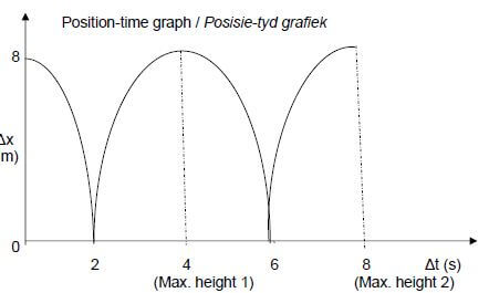
Criteria for graph
- The height from which the ball was dropped
- The times when the ball was at its maximum height - 4 s and 8 s
- Shape of the graph/Vorm van die grafiek (3) [8]
QUESTION 6
6.1 The total linear momentum of an isolated system is conserved.
OR
In an isolated system the total linear momentum before collision is equal to the total linear momentum after collision. (2)
6.2
- ∑pi = ∑pf
mvViv + mcVic = mvVfv +mcVfc
1500 x 30 + 1200 x 80000 = 1500 Vfv + 1200 x 25
3600
Vfv = 27,78 m.s-1 in the same direction (5)
6.3 (3)
| OPTION 1 | OPTION 2 |
| ∆p = mvf - mvi ∆p = 1200 x 25 - 1200 x 80000 3600 ∆p = 3333,33 kg.m.s-1 In the direction of the motion | ∆p = mvf - mvi ∆p = 1500 x 27,78 - 1500 x 30 ∆p = -3330 kg.m.s-1 ∆p = 3330 kg.m.s-1 In the direction of the motion |
6.4
- ∑Eki = ½ m vic2 + ½mviv2
∑Eki = ½ x 1200 x (80000)2+ ½ x 1500 x 302
3600
∑Eki = 971296,30 J
∑Ekf = ½m vfc2 + ½mvfv2
∑Ekf = ½ x 1200 x (25)2+ ½ x 1500 x 27,782
∑Ekf = 953796,30 J
∑Eki ≠ ∑Ekf
Collision is inelastic (5) [15]
QUESTION 7
7.1 To the right
For momentum to be conserved:
- momentum of trolley B = momentum of trolley A.
- momentum of B must be in an opposite direction to the momentum of trolley A (3)
7.2 Let right/East be positive
- Σpi = Σpf
mAvAi + mBvBi = mAvAf + mBvBf Any one
(mA + mB) vi = mAvAf + mBvBf
(0,5 + 0,75) x 0 = 0,5 x (-2,5) + 0,75vBf
vBf = 1,66 m.s-1 (to the right/East) (4)
7.3.1 21,5 N
- According Newton’s Third law of motion, when the wall exerts a force on the trolley, the trolley simultaneously exerts a force (of 21,5 N) on the wall but in an opposite direction.
NOTE: If learners just state Newton’s third law without using it to explain, no marks will be awarded (3)
7.3.2
- Fnet ∆t = m ∆v Any one
Fnet ∆t = m ∆(vAf - vAi)
-21,5 x 0,1 = 0,5(vAf - 2,5)
-2,15 = 0,5 vAf - 1,25
vAf = -1,8 m.s-1
vAf = 1,8 m.s-1 (to the left/west) (5)
7.3.3 Remains the same.
- When the contact time increases, the net force decreases. (3) [18]
QUESTION 8
8.1 The (total) mechanical energy of an isolated system is conserved. (2)
8.2 (4)
| OPTION 1 | OPTION 2 |
| MEB = MEC (EP + EK)B = (EP + EK)C (mgh + ½m v2)B = (mgh + ½m v2)B 0+ ½(0,2)vi2 = 0,2(9,8)(1,2)+ 0 Vi = 4,85 m.s-1 | Wnc = ∆Ek + ∆Ep 0 = ½m vf2 - ½m vi2 + mgh2 - mgh1 0 =0 - ½(0,2)vi2 + 0,2(9,8)(1,2) - 0 Vi = 4,85 m.s-1 |
8.3
| OPTION 1 | OPTION 2 | OPTION 3 |
| ∆x = vf + vi ∆t 2 = 6 + 4,85 x 0,82 2 = 4,45m | vf = vi + a∆t 4,85 = 6 + a x 0,82 a = - 1,40 m.s-2 ∆x = vi∆t + ½ a∆t2 = 6x0,82 + 0,5xax0,822 = 4,45 m | vf = vi + a∆t 4,85 = 6 + a x 0,82 a = - 1,40 m.s-2 vf2 = vi2 + 2a∆x 4,852 = 62 + 2(-1,4) ∆x ∆x = 4,46 m |
(3) [9]
QUESTION 9
9.1The net work done on an object is equal to the change in the kinetic energyof the object.
OR
The amount of work done by a net force on object is equal to the change in the object’s kinetic energy. (2)
9.2 (4)
| OPTION 1 | OPTION 2 |
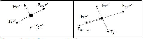 | |
- Mark awarded for both the arrow and label
- Do not penalise for length of forces since drawing is not drawn to scale.
- If force(s) do not make contact with body
9.3 OPTION 1
- Wnet = ∆EK
Wnet = WApp + W// + Wf
WApp + W// + Wf = ∆EK Any one
260(8)Cos0°) + 0,16(25)(9,8)(Cos40°)(8)(Cos180°) + 25(9,8)(sin40°)(8)(Cos180°) = ½(25)vf2 - 0
2080 - 240,23 -1259,86 = 12,5 vf²
579,91 = 12,5 vf2
vf = 6,81 m.s-1
OPTION 2
- Wnc = ∆EK+ ∆Ep
Wapp + Wf = ∆EK+ WFg Any one
260(8)(cos0°) + 0,16(25)(9,8)(Cos40°)(8)(cos180°) = 25(9,8)(Sin40°)(8)(cos180°) + ½ (25)vf2 - 0
vf = 6,81 m.s-1 (6)
9.4
| OPTION 1 | OPTION 2 |
| ∆x = (vi + vf) ∆t 2 8 = (0 + 6,81) ∆t 2 ∆t = 2,35s P = W ∆t P = 2080 2,35 = 885,11 W | Vav = vf + vi 2 Vav = 0 + 6,81 2 Vav = 3,405 Pav = F.Vav Pav = 260 × 3,405 = 885,11 W |
(4) [16]
QUESTION 10
10.1.1 Doppler effect is the change in frequency (or pitch) of the sound detected by a listener, because the sound source and the listener have different velocities relative to the medium of sound propagation
OR
Doppler effect is the apparent change in frequency of a wave when thereis relative motion between the source and an observer
OR
Doppler Effect is an (apparent) change in observed/detected frequency(pitch), (wavelength) as a result of the relative motion between a source and an observer (listener) (2)
10.1.2 750 Hz
10.1.3
- Waves are compressed as Khosi moves towards the source.
- Wavelength become shorter.
- Wavelength is inversely proportional to frequency, hence the detected frequency is higher. (3)
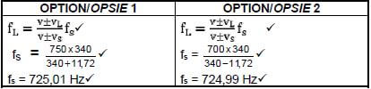
10.1.4
- FL = V ± VL FS
V ± VS
When Khosi approaches - 750 = 340 +vL fs
340
fs = 750 × 340 ................ (1)
340 + vL
When the Khosi moves away - 700 = 340 - vL
340
fs = 750 × 340 ................ (2)
340 + vL
(1)=(2): - 750 × 340 = 750 × 340
340 + vL 340 + vL
750(340 + vL) = 700(340 + vL)
1450vL = 17000
vL =11,72 m.s-1 (6) (3)
(3)
 (3)
(3)10.2.1
- Away
- It shows a red shift.
- Frequency is decreasing.
- Wavelength becomes longer. (4)
10.2.2The universe is expanding. (1) [20]
QUESTION 11
11.1 The force per unit positive charge. (2)
11.2
- E = kQ
r2 Any one
Enet = E1 + E2 (6) [8]
 (6) [8]
TOTAL: 150
TECHNICAL SCIENCES PAPER 2 GRADE 12 QUESTIONS - NSC EXAMS PAST PAPERS AND MEMOS JUNE 2019
TECHNICAL SCIENCES
PAPER 2
GRADE 12
NSC EXAMS
PAST PAPERS AND MEMOS JUNE 2019
INSTRUCTIONS AND INFORMATION
Read the following instructions carefully before answering the questions.
- Write your FULL NAME and SURNAME in the appropriate spaces on the ANSWER SHEET.
- Answer ALL the questions.
- Start each question on a NEW page in the ANSWER BOOK.
- You may use a non-programmable calculator.
- You may use appropriate mathematical instruments.
- Number the answers correctly according to the numbering system used in this question paper.
- Show ALL formulae and substitutions in ALL calculations.
- Round off your FINAL numerical answers to a minimum of TWO decimal places.
- Give brief motivations, discussions et cetera where required.
- A data sheet is attached for your use.
- Write neatly and legibly.
QUESTIONS
QUESTION 1: MULTIPLE-CHOICE QUESTIONS
Various options are provided as possible answers to the following questions. Write down the question number (1.1–1.10), choose the answer and write the letter (A–D) of your choice in the ANSWER BOOK, for example 1.11 A.
1.1 A group of atoms that determine the chemistry of a molecule is called a …
- functional isomer.
- general formula.
- homologous series.
- functional group. (2)
1.2 Butane is used in aerosol spray cans. In which phase is butane at room temperature?
- Liquid
- Plasma
- Gas
- Solid (2)
1.3 C2H6, C2H5OH and CH3COOH are the organic compounds that are investigated by learners to determine their viscosities. Which ONE will be less viscous?
- C2H5OH
- C2H6
- CH3COOH
- C2H5OH and CH3COOH (2)
1.4 Consider the flow diagram below and answer the questions that follow. 
Which of the following correctly represent the reaction conditions for reactions A and B respectively. (2)
Reaction A | Reaction B | |
A | Excess water and a little amount of acid H3PO4 | Catalyst Pd |
B | Insufficient water and H2SO4 | No catalyst |
C | No water and H3PO4 | Catalyst H2SO4 |
D | Excess water and no acid | No catalyst |
1.5 A synthetic material that is derived from organic compounds:
- Polyethene
- Polymerisation
- Plastic
- Polymer (2)
1.6 The bending of light when it passes from one medium to another:
- Reflection
- Diffraction
- Refraction
- Rarefaction (2)
1.7 The diagram below shows the path of light ray, D, hitting a plane mirror. Angles r1, r2, r3 and r4 respectively represent the angles of reflection formed. 
Which of the following is true about the reflected ray and the angle of reflection?
- F is the reflected ray, r1 is the angle of reflection
- G is the reflected ray, r2 is the angle of reflection
- I is the reflected ray, r3 is the angle of reflection
- J is the reflected ray, r4 is the angle of reflection (2)
1.8 Which of the following diagrams represents the phenomenon of total internal reflection? (2)
1.9 A light ray travels from air into water. Which ONE of the following combinations, relating to the angle of refraction and angle of incidence, is correct? (2)
Angle of Refraction | Angle of Incidence | |
A | Equal to angle of incidence | Equal to angle of refraction |
B | Less than angle of incidence | Greater than angle of refraction |
C | Greater than angle of incidence | Less than angle of refraction |
D | No change in angle | No change in angle |
1.10 Which ONE of the following electromagnetic waves has the shortest wavelength?
- Radio waves
- Gamma rays
- Infrared rays
- Ultraviolet rays (2) [20]
QUESTION 2 (Start on a new page.)
The letters A–H in the table below represent eight organic compounds from different sets of homologous series. 
2.1 Define the term homologous series. (2)
2.2 For each of the following compounds, write down the homologous series to which they belong, as well as the name of their functional group:
2.2.1 B (1)
2.2.2 C (1)
2.2.3 G (1)
2.3 Predict the type of reactions these compounds will undergo when they come into contact with bromine. Answer only addition / substitution.
2.3.1 A (1)
2.3.2 H (1)
2.4 Write down letter (s) that represent the following:
2.4.1 Structural isomers (2)
2.4.2 Unsaturated hydrocarbon (1)
2.4.3 Organic compounds with hydrogen bond (2)
2.5 Give the IUPAC name of compound:
2.5.1 A (2)
2.5.2 C (1)
2.6 Write down the structural formula of:
2.6.1 Compound E (3)
2.6.2 Monomer of compound F (2) [20]
QUESTION 3 (Start on a new page.)
Study the graph and answer the questions that follow. 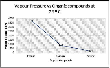
3.1 Why, are these organic compounds referred to as unsaturated hydrocarbons? (1)
3.2 Mention the intermolecular forces found in these organic compounds. (1)
3.3 Define vapour pressure. (2)
3.4 From the graph, identify the following:
3.4.1 The independent variable (1)
3.4.2 The controlled variable (1)
3.5 Describe the trend in the vapour pressures of these compounds. (2)
3.6 Explain the trend mentioned in QUESTION 3.5 above. (3)
3.7 Draw the structural isomer of butane. (2)
3.8 How will the vapour pressure of this isomer compare to that of butane? Answer only HIGHER THAN / LOWER THAN/ EQUAL TO. (1)
3.9 Explain the answer given in QUESTION 3.6 above. (3)
3.10 Which of the compounds from the graph will have the lowest boiling point? (1) [18]
QUESTION 4 (Start on a new page.)
The table below shows the melting points and viscosities of three organic compounds. Study the table very carefully and answer the questions that follow.
COMPOUND | MELTING POINT (°C) | VISCOSITY (c P) |
Butane | 135 | 0,01 |
Butanal | 174 | 0,4 |
Butanol | 183 | 3,0 |
4.1 Butanal and butanol have equal number of carbon atoms but their viscosities are different.
4.1.1 Briefly explain the difference in viscosities. (3)
4.1.2 Mention the type of intermolecular forces these compounds have in common. (1)
4.1.3 Explain why is it important not to work with butanol near open fires. (1)
4.2 Which chemical property of butane and butanol makes it possible for them to be used as fuels? (1)
4.3 Consider the melting points of the compounds in the table, range between 135 °C and 183 °C. Give a reason for this difference in melting points by referring to the type of intermolecular forces present in EACH of these compounds. (3)
4.4 Write down a balanced molecular equation for the complete combustion of butane. (3) [12]
QUESTION 5 (Start on a new page.)
Reactions of pentene are represented in the flow diagram below. 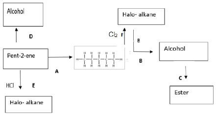
5.1 What type of reaction is represented by each of the following?
5.1.1 A (1)
5.1.2 E (1)
5.2 Both reaction B and D produce alcohol as the product through different types. Explain the difference in these reactions. Refer to SATURATED / UNSATURATED status of hydrocarbons, REACTION TYPE(S) in each reaction and REACTION CONDITIONS required. (3)
5.3 Give the IUPAC name of the alcohol(s) formed in reactions D and B. (1)
5.4 Is the alcohol formed a:
5.4.1 Primary / secondary / tertiary alcohol? (1)
5.4.2 Minor / major product? (1)
5.5 Draw the structural formula of halo-alkane formed in reaction E. (2)
5.6 Use a structural formula to write down a balanced equation between methanoic acid and alcohol formed in reaction B. NOTE: Both alcohol and carboxylic acid must be correctly oriented . (4)
5.7 Give the industrial use of the process represented by reaction A. (1) [15]
QUESTION 6 (Start on a new page.)
6.1 Light is shone on a flat mirror at an angle of 30° as shown in the diagram. Study the diagram and answer the questions that follow. 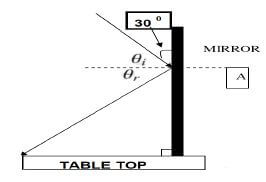
6.1.1 State the law of reflection. (2)
6.1.2 Define the line marked A. (2)
6.1.3 If the light is shone at 30°, what is the magnitude of the angle of incidence θi? (1)
6.1.4 How does the magnitude of the angle of reflection, θr, compare to the angle of incidence? (1)
6.2 A learner placed a container of capsules in front of the flat mirror above and observed the image formed. 
Observation:
The learner went behind the mirror to observe the image but to his surprise he noticed that no image was found behind the mirror. He could only see the image in the mirror.
6.2.1 How does the height of the image compare to that of the container of capsules? (1)
6.2.2 Explain, using the law of reflection, why the learner sees an image in the mirror, instead of seeing an image behind the mirror. (3)
6.2.3 Describe the image formed. (2) [12]
QUESTION 7 (Start on a new page.)
A beam of white light hits a triangular prism, bends and the angle between incident ray and the emergent ray forms. 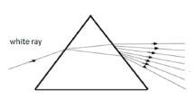
7.1 Define dispersion of light. (2)
7.2
7.2.1 Give a single scientific term for the underlined phrase. (1)
7.2.2 Draw a labelled diagram to show the path of light through the triangular prism. (NOTE: Do not label the angle mentioned in QUESTION 7.2.1 above). (7) 7.3 Give TWO conditions for total internal reflection. (2)
7.4 Most optical equipment like periscopes, telescopes and binoculars use prisms and total internal reflection and not mirrors. 
Why is it important to use prisms and total internal reflection in binoculars and periscopes over mirrors? (2) [14]
QUESTION 8 (Start on a new page.)
8.1 A group of Grade 12 learners on a field trip is trying to start a fire by using a lens to focus the sun’s rays onto pieces of paper. They used a certain type of a lens to kindle the fire and their set up is represented in a diagram below. 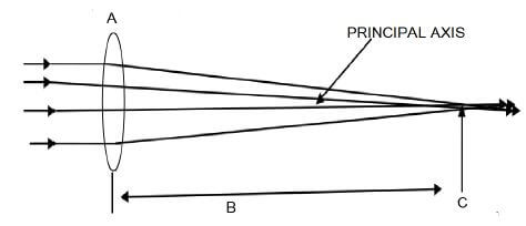
8.1.1 What type of lens is represented by A? (1)
8.1.2 What is the principal axis? (2)
8.1.3 Provide a label for B. (1)
8.1.4 Define the physical quantity represented by letter C. (2)
8.2 Explain how the group of learners should place the lens relative to pieces of paper, in order to ignite it as quickly as possible. (2)
8.3 After setting up the fire, the group of learners cleaned the lens and placed a 4 cm high splinter of wood at a distance of 8 cm from a lens with a focal point of 6 cm.
8.3.1 Make use of a scale drawing to determine the position of the image. (4)
8.3.2 Identify THREE properties of the image formed. (3) [15]
QUESTION 9 (Start on a new page.)
9.1 Electromagnetic waves (are waves that) are created as a result of changing magnetic and electric fields which are mutually perpendicular to each other and to the direction of propagation. These waves form an electromagnetic spectrum in which each wave has an important use. Valuable items such as bank notes and passports can be security marked using fluorescent ink. The ink can only be seen in ultraviolet radiation and is used to differentiate between genuine and counterfeit notes or passports. 
Name the type of electromagnetic radiation that is used in:
9.1.1 Radar and communication systems (1)
9.1.2 The detection of radioactive tracers (1)
9.1.3 Special lamps by fast-food restaurants to heat food (1)
9.2 Briefly explain how the South African Police Service (SAPS) uses ultraviolet radiation in forensic science to investigate crime scenes. (3)
9.3 The security officer at the airport is using a certain type of electromagnetic wave to detect hidden weapons and other dangerous items in passengers’ luggage to ensure the safety of other passengers. 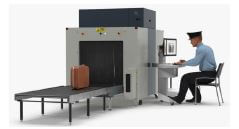
9.3.1 Name the type of electromagnetic waves used at the airport. (1)
9.3.2 Compare the wavelength, frequency and penetrating ability of the waves mentioned in QUESTION 9.3.1, to that of microwaves as well as those waves mentioned in QUESTION 9.1.2 above. (3)
9.4 The table below shows different energies that were measured at different wavelengths for an electromagnetic wave. Study the table and answer the questions that follow.
E (x 10 -19 J) | λ (x 10 -9 m) | f (Hz) |
2,35 | 857 | |
2,45 | 833 | |
2,55 | 789 | |
2,65 | 752 | |
2,75 | 723 | |
2,85 | 699 |
9.4.1 Complete the table by calculating all values of frequency f. (2)
9.4.2 Refer to the table to describe the trend between the values of frequency, f, calculated in QUESTION 9.4.1 and the wavelength above. (2)
9.4.3 Plot the points of E vs f. Draw the line of best fit on the graph. (3)
9.4.4 From the graph drawn, give a single term for the ratio E/f. (1)
9.5 Photons of an electromagnetic wave have an energy of 2,83 x 10⁻²⁵ J. Calculate:
9.5.1 The frequency of the wave (3)
9.5.2 The wavelength of the wave (3) [24]
TOTAL: 150
NATIONAL SENIOR CERTIFICATE
DATA FOR TECHNICAL SCIENCES GRADE 12
PAPER 2
TABLE 1: PHYSICAL CONSTANTS
NAME | SYMBOL | VALUE |
Planck’s constant | h | 6,63 × 10⁻³⁴ J·s |
Speed of light | C | 3 × 10⁸ m·s-1 |
TABLE 2: FORMULAE
WAVES, SOUND AND LIGHT | |
Speed | c=fλ |
Energy | E=hf Or E = hc |
TECHNICAL SCIENCES PAPER 1 GRADE 12 QUESTIONS - NSC EXAMS PAST PAPERS AND MEMOS JUNE 2019
TECHNICAL SCIENCES
PAPER 1
GRADE 12
NSC EXAMS
PAST PAPERS AND MEMOS JUNE 2019
INSTRUCTIONS AND INFORMATION
Read the following instructions carefully before answering the questions.
- Write your full NAME and SURNAME in the appropriate spaces on the ANSWER BOOK.
- The question paper consists of EIGHT questions.
- Start each question on a NEW page in the ANSWER BOOK.
- You may use a non-programmable calculator.
- You may use appropriate mathematical instruments.
- Number the answers correctly according to the numbering system used in this question paper.
- Show ALL formulae and substitutions in ALL calculations.
- Round off your FINAL numerical answers to a minimum of TWO decimal places.
- Give brief motivations, discussions, et cetera where required.
- A data sheet is attached for your use.
- Write neatly and legibly.
QUESTIONS
QUESTION 1: MULTIPLE-CHOICE QUESTIONS
Various options are provided as possible answers to the following questions. Choose the answer and write the letter (A−D) next to the question number (1.1−1.10) in the ANSWER BOOK, for example 1.11 D.
1.1 Which ONE of the following is a measure of the inertia of a body?
- Force
- Mass
- Density
- Acceleration (2)
1.2 The velocity of a car moving eastwards increases from 5 m.s-1to 10 m.s-1. 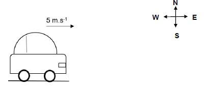
Which ONE of the following statements CORRECTLY describes the direction of the acceleration and the resultant (net) force while the car is accelerating? (2)
Direction of acceleration | Direction of resultant force | |
A | Due east | Due west |
B | Due west | Due east |
C | Due east | Due east |
D | Due west | Due west |
1.3 An object moves with constant velocity along a rough surface when a horizontal force of 5 N acts on it. 
The magnitude of the kinetic frictional force is …
- equal to zero.
- equal to 5 N.
- greater than 5 N.
- less than or equal to 5 N. (2)
1.4 Which ONE of the following is equal to the rate of change of momentum?
- Impulse
- Velocity
- Net force
- Acceleration (2)
1.5 A bricklayer wants to displace an object through a horizontal distance of 5 m. He applies a force of 10 N, but the object remains at rest. Work done by the brick layer on the object (in Joule) is …
- 0.
- 5.
- 10.
- 50. (2)
1.6 A girl pulls a box horizontally across a rough floor. The box moves in an easterly direction. The diagram below shows the force diagram of all the forces that act on the box.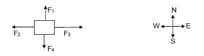
Which ONE of the following forces does NEGATIVE work on the box?
- F1
- F2
- F3
- F4 (2)
1.7 A ball, moving horizontally east, hits a wall with a speed v m.s-1. The ball then bounces back horizontally with the same speed v m.s-1 as shown in the diagram below. 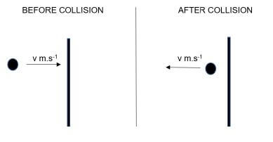
Which ONE of the following statements is TRUE about momentum p and kinetic energy Ek of the ball during the collision?
- Only p is conserved
- Only Ek is conserved
- Both p and Ek are conserved
- Both p and Ek are not conserved (2)
1.8 Which ONE of the following is defined as the normal force exerted by a liquid at rest on a given surface in contact with the liquid?
- Thrust
- Weight
- Stress
- Pressure (2)
1.9 Strain is defined as the …
- force acting per unit area.
- internal restoring force per unit area.
- force that changes the shape of an object.
- ratio of change in dimension to the original dimension. (2)
1.10 A material that has electrical conductivity between that of a conductor and an insulator is called a …
- metal.
- plastic.
- semiconductor.
- transition metal. (2) [20]
QUESTION 2 (Start on a NEW page.)
2.1 A girl is pulling a concrete block of mass 20 kg across a rough horizontal surface with a horizontal force of 50 N due east as shown in the diagram. The coefficient of kinetic friction is 0,2. 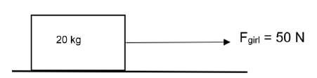
2.1.1 Draw a free-body diagram showing ALL forces acting on the block. (4)
2.1.2 Calculate the kinetic frictional force experienced by the block. (4)
2.1.3 Determine the magnitude and direction of the net force acting on the block. (4)
2.1.4 State Newton’s Second Law of motion in words. (2)
2.1.5 Calculate the magnitude of the acceleration of the block. (3)
2.2 How does the acceleration in QUESTION 2.1.5 change if: (Write only INCREASES, DECREASES or REMAINS THE SAME)
2.2.1 Another block of mass 5 kg is attached to the 20 kg block by using a light string (1)
2.2.2 The 50 N force is acting at an angle of 20° with the horizontal (1)
2.2.3 The 20 kg block is placed on a smooth surface (1) [20]
QUESTION 3 (Start on a NEW page.)
3.1 A man pushes a car with a force of 100 N due east as shown in the figure. The car moves as the force is applied. 
3.1.1 State Newton’s Third Law in words. (2)
3.1.2 What is the magnitude and direction of the force exerted by the car on the man? (2)
3.2 A box is placed on top of a car which was initially at rest. The car suddenly starts to move due east. 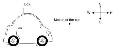
3.2.1 Describe what happens to the box when the car suddenly moves due east. (2)
3.2.2 Explain the answer to QUESTION 3.2.1 by referring to the relevant law in physics. (3) [9]
QUESTION 4 (Start on a NEW page.)
4.1 A design engineer in charge of the crashworthiness of new vehicle models conducts experiments by smashing them into fixed massive barriers at 14 m.s-1. A new model of a car of mass 1 500 kg takes 0,15 s from the time of impact until it is brought to rest.
4.1.1 Define the term impulse. (2)
4.1.2 Is impulse a vector or a scalar quantity? (1)
4.1.3 Calculate the impulse of the car. (4)
4.1.4 Calculate the magnitude of the force exerted by the barrier on the car. (3)
4.1.5 New cars have a crumple zone to help minimise injuries during accidents. Use principles in physics to explain how crumple zones help to minimise injuries during a collision. (3)
4.2 Car A of mass 800 kg is stationary at a traffic light. Another car, B, of mass 1 000 kg travelling at a speed of 33 m.s-1 collides with car A from behind as shown in the diagram below. Immediately after the collision car A moves to the right at 17 m.s-1. The kinetic energy is not conserved during the collision. 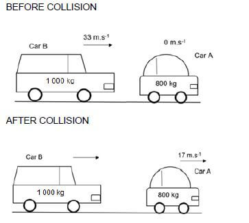
4.2.1 Define the term momentum. (2) 4.2.2 Differentiate between an elastic and inelastic collision. (4)
4.2.3 State the principle of conservation of linear momentum in words. (2)
4.2.4 Calculate the speed of car B after the collision. (4)
4.2.5 Is this collision elastic or inelastic? (1) [26]
QUESTION 5 (Start on a NEW page.)
5.1 A construction worker is pulling a box of mass 100 kg across a rough horizontal surface. The worker exerts a force 200 N at an angle 20° with the horizontal. The box moves at a constant velocity of 3 m.s-1to the left. The box is pulled over a distance of 5 m. 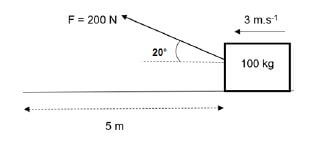
5.1.1 Define the term work done in words. (2)
5.1.2 Calculate the work done by the worker. (3)
5.1.3 What is the net work done on the box? (1)
5.1.4 Explain the answer in QUESTION 5.1.3 above. (2)
5.1.5 Does the force of gravity do any work on the box? Explain. (3)
5.2 An electric motor lifts 2 000 kg of water per minute to the top of a building which is 20 m high.
5.2.1 Define the term power. (2)
5.2.2 Calculate the power generated by the motor in horsepower. (4)
5.3 A block of mass m is dropped from rest from a height h metres above the ground as shown in the following diagram.
The block reaches point B, which is 1,5 m above the ground at a speed of 8 m.s-1. 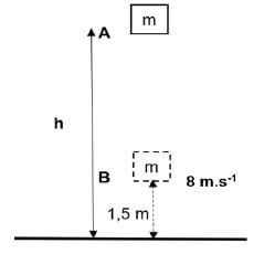
5.3.1 Define mechanical energy in words. (2)
5.3.2 Define gravitational potential energy in words. (2)
5.3.3 What change takes place on the following quantities while the block is falling? Write down only INCREASES, DECREASES or REMAINS THE SAME.
- Kinetic energy (1)
- Mechanical energy (1)
5.3.4 State the principle of conservation of mechanical energy in words. (2)
5.3.5 Calculate the height h from which the block was dropped. (7) [32]
QUESTION 6 (Start on a NEW page.)
6.1 Distinguish between a perfectly elastic body and a perfectly plastic body. (4)
6.2 State Hooke’s law in words. (2)
6.3 A string of length 2 m has an area of 5 x 10⁻⁵ m2.The string is pulled by a force of 200 N. The modulus of elasticity of the string is 4 x 10⁸ N.m-2.
6.3.1 Define stress in words. (2)
Calculate the:
6.3.2 Stress on the string (3)
6.3.3 Final length of the string (6) [17]
QUESTION 7 (Start on a NEW page.)
7.1 Define viscosity. (2)
7.2 Modern engine oils are specially designed as multi-grades. Motor oils that are marked 10W40 and 5W40 are shown in the diagram below. 
7.2.1 What does “W” in 10W40 represent? (2)
Which ONE of the two types of motor oils (10W40 or 5W40):
7.2.2 Has a higher viscosity at engine start up? (2)
7.2.3 Is recommended for the winter season? (2)
7.3 A hydraulic system is used to lift patients in a dentistry chair. A force of 100 N is applied on Piston A, with an area of 1,2 x 10⁻³ m2, to lift a patient of weight 1 200 N. 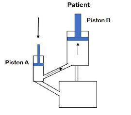
7.3.1 State Pascal’s law in words. (2)
7.3.2 Calculate the area of the Piston B. (3)
A doctor wants to lift a heavier patient but with a smaller applied force.
7.3.3 What design change must the doctor make to the system to achieve this? (2)
7.3.4 Give THREE applications of Pascal’s law. (3) [18]
QUESTION 8 (Start on a NEW page.)
An intrinsic semiconductor silicon, Si, is doped with an impurity element to produce an n-type semiconductor.
8.1 What is an intrinsic semiconductor? (2)
8.2 Define the term doping. (2)
8.3 Give the name of the impurity element that was added to produce an n-type semiconductor. (2)
8.4 What type of charge causes conduction in an n-type semiconductor? (2) [8]
TOTAL: 150
DATA FOR TECHNICAL SCIENCES GRADE 12
PAPER 1
TABLE 1: PHYSICAL CONSTANTS
NAME | SYMBOL | VALUE |
Acceleration due to gravity | g | 9,8 m·s-2 |
Permittivity of free space | ε0 | 8,85 × 10⁻² F.m-1 |
TABLE 2: FORMULAE
FORCE
Fnet = ma | p= mv |
fsmax = µsN | fk = µkN |
FnetΔt = Δp | Fg =mg |
WORK, ENERGY AND POWER
W =FΔxcosθ | U= mgh or EP = mgh |
K = ½mv2 or Ek = ½mv2 | Wnet = ΔK or Wnet = ΔEk ΔK = Kf −Ki or ΔEk =Ekf − Eki |
Wnc= ΔK + ΔU or Wnc= ΔEk + ΔEp | P = W Δt |
Pav = Fv | ME = Ek+ Ep |
ELASTICITY, VISCOCITY AND HYDRAULICS
| σ = F A | ε = Δl / Strain = Change in length L Original length |
| σ = K / Stress = Modulus of elasticity ε Strain | F1 = F2 A1 A2 |
| P = pgh | Pressure (P) = Force(F) Area |
TECHNICAL SCIENCES PAPER 1 GRADE 12 MEMORANDUM - NSC EXAMS PAST PAPERS AND MEMOS JUNE 2019
TECHNICAL SCIENCES
PAPER 1
GRADE 12
NSC EXAMS
PAST PAPERS AND MEMOS JUNE 2019
MEMORANDUM
QUESTION 1
1.1 B ✓✓ (2)
1.2 C ✓✓ (2)
1.3 B ✓✓ (2)
1.4 C ✓✓ (2)
1.5 A ✓✓ (2)
1.6 B ✓✓ (2)
1.7 C ✓✓ (2)
1.8 A ✓✓ (2)
1.9 D ✓✓ (2)
1.10 C ✓✓ (2) [20]
QUESTION 2
2.1
2.1.1 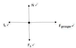 (4)
(4)
2.1.2
- fk = µkN ✓
fk = (0,2)(20)(9,8) ✓✓
= 39,2 N West ✓ (4)
2.1.3
- Fnet = fk + Fgirl✓
= (-39,2) ✓ + ( 50) ✓
= 10,8 N east ✓ (4)
2.1.4
- When a net force acts on an object of mass m, it accelerates the object in the direction of the net force. This acceleration is directly proportional to the net force and inversely proportional to the mass of the object. ✓✓ (2)
2.1.5
- Fnet = ma ✓
10,8 = (20)a ✓
a = 0,54 m.s-2 ✓ (3)
2.2
2.2.1 Decreases ✓ (1)
2.2.2 Increases✓ (1)
2.2.3 Increases✓ (1) [20]
QUESTION 3
3.1
3.1.1 When object A exerts a force on object B, object B simultaneously exerts an oppositely directed force of equal magnitude on object A. ✓✓ (2)
3.1.2 100 N due west ✓✓ (2)
3.2
3.2.1 Box thrown backward ✓✓ (2)
3.2.2 The box opposes a change in its state of rest ✓ due to its inertia ✓ according to Newton’s first law of motion. ✓ (3) [9]
QUESTION 4
4.1
4.1.1 Impulse is the product of the net force acting on an object and the time the net force acts on the object. ✓✓ (2)
4.1.2 Vector ✓ (1)
4.1.3
- Impulse = ∆p or Impulse = m∆v ✓
Impulse = (1 500)(0 – 14) ✓✓
= (- 21 000 N.s ✓ (kg.m.s-1)
= 21 000 N.s away from the barrier (4)
4.1.4
- Fnet = Δp ✓
Δt
Fnet =-21000
0,5
Fnet = -42 000 N ✓ (3)
4.1.5
- Crumple zone helps the car to take a longer time to come to a stop ✓. Fnet∆t = ∆p, the longer the time interval, the smaller the net force acting for the same ∆p ✓.
∴ the injuries are minimised. ✓ (3)
4.2
4.2.1 Momentum is defined as the product of an object's mass and its velocity. ✓✓ (2)
4.2.2
- Elastic collision: A collision in which both the momentum and kinetic energy are conserved. ✓✓
- Inelastic collision: A collision in which only the momentum is conserved.✓✓ (4)
4.2.3
- The total linear momentum of an isolated system remains constant (is conserved). ✓✓ (2)
OR - Total linear momentum before collision is equal to the total linear momentum after the collision in an isolated system. ✓✓
4.2.4
- Σpbefore = Σpafter
mAvAinitial + mBvBinitial = mAvAfinal + mBvBfinal ✓ Any ONE
(800)(0) + (1000)(33) ✓ = (800)(17) + (1000)(v) ✓
v = 19,4 m.s-1 ✓ (4)
4.2.5 Inelastic ✓ (1) [26]
QUESTION 5
5.1
5.1.1 Work done is defined as the product of the force acting on an object and the displacement in the direction of the force. ✓✓ (2)
5.1.2
- W = F∆x cos θ ✓
W = (200)(5) cos 20° ✓
W = 939,69 J ✓ (3)
5.1.3 0 ✓ (J) (1)
5.1.4 Box moves with constant velocity. ✓ Net force is zero. ✓ (Hence the net work done is 0 J.) (2)
5.1.5
- No. ✓ Force of gravity is perpendicular to the direction of motion.✓✓
OR - W = F∆xcosθ ✓
= F∆xcos90o ✓
= 0 J ✓ (3)
5.2
5.2.1 Power is defined as the rate at which work is done OR rate at which energy is expended. ✓✓ (2)
5.2.2
- P = w ✓
Δt
P = (2000)(9,8)(20)
60
P = 6533,33 W ✓
P = 6533,33 = 8,76 hp / pk ✓ (4)
746
5.3
5.3.1 Sum of gravitational potential energy and kinetic energy. ✓✓✓✓ (2)
5.3.2 Energy possessed by an object due to its position above the ground. ✓✓ (2)
5.3.3 (a) Increases✓ (1) (b) Remains the same✓ (1)
5.3.4 The total mechanical energy in an isolated system remains constant. ✓✓ (2)
5.3.5
- ME (B) = mgh + 1/2 mv2 ✓
= m(9,8)(1,5) + 1/2m(8)2 ✓
= 46,7 m ✓ - ME(A) = mgh + 1/2mv2
= m(9,8)h + 0 ✓
= 9,8 mh ✓ - ME (A) = ME(B) ✓
9,8 mh = 46,7 m
h = 4,77 m ✓ (7) [32]
QUESTION 6
6.1
- A perfectly elastic body: A body which regains its original shape and size completely when the deforming force is removed. ✓✓
- A perfectly plastic body: A body that does not show a tendency to regain its original shape and size when the deforming force is removed. ✓✓ (4)
6.2 Hooke’s law: Within the limit of elasticity, ✓ stress is directly proportional to the strain.✓ (2)
6.3
6.3.1 Stress is internal restoring force per unit area of a body. ✓✓ (2)
6.3.2
- σ = F
A
σ = 200
5 × 10⁻⁵ ✓
σ = 4 000 000 Pa ✓ (3)
6.3.3
- K = σ ✓
ε
4 × 10⁸ ✓ = 4 000 000
ε
ε = 0,01
ε = Δl
L
0,01 = Δl ✓
2
∆l = 0,02 m ✓
Final length e = 2 + 0,02 = 2,02 m ✓ (6) [17]
QUESTION 7
7.1 Viscosity is defined as the property of a fluid to oppose relative motion between the two adjacent layers. ✓✓ (2)
7.2
7.2.1 Winter ✓✓ (2)
7.2.2 10W40 ✓✓ (2)
7.2.3 5W40 ✓✓ (2)
7.3
7.3.1 Pascal's law: In a continuous liquid at equilibrium, the pressure applied at a point is transmitted equally to the other parts of the liquid. ✓✓ (2 OR 0) (2)
7.3.2
- F1 = F2 ✓
A1 A2
100 = 1200
1,2 × 10⁻³ A2
A2 = 0,014 m2 ✓ (3)
7.3.3 Increase the area of piston B. ✓✓ (2)
7.3.4 Bulldozer's working systems, hydraulic power brakes on automobiles, dentists' chairs, hydraulic lifts used to lift heavy loads, car jacks, or any other correct application. (ANY THREE) ✓✓✓ (3) [18]
QUESTION 8
8.1 An intrinsic semiconductor is a pure semiconductor. ✓✓ (2)
8.2 Doping is the process of adding impurities to intrinsic semiconductors. ✓✓ (2)
8.3 Phosphorous or arsenic✓✓ (2)
8.4 Negative charge/negatiewe lading ✓✓ (2) Electron [8]
TOTAL: 150
GEOGRAPHY PAPER 1 GRADE 12 ANNEXURE - NSC EXAMS PAST PAPERS AND MEMOS JUNE 2019
GEOGRAPHY
PAPER 1
GRADE 12
NSC EXAMS
PAST PAPERS AND MEMOS JUNE 2019
ANNEXURE
FIGURE 1.2: TYPES OF RIVERS 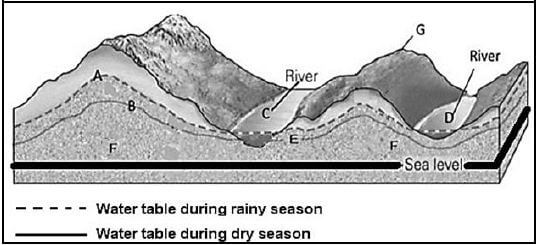
[Adapted from http://geologylearn.blogspot.co.za/2015/12/groundwater-flow.html]
FIGURE 1.3: SYNOPTIC WEATHER MAP DEPICTING A MID-LATITUDE CYCLONE 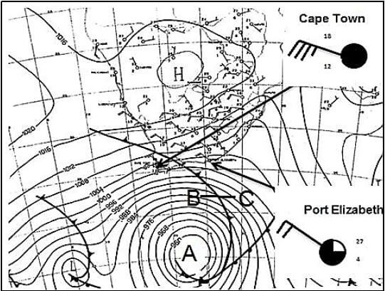
[Adapted from www.google.co.za/search=consecutive+sinoptic+maps+south]
FIGURE 1.4: SATELLITE IMAGE OF A TRAVELLING DISTURBANCE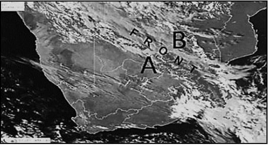
[Adapted from This email address is being protected from spambots. You need JavaScript enabled to view it.]
FIGURE 1.5: DRAINAGE PATTERNS AND DENSITY 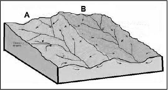
[Adapted from http//: www.Google images]
FIGURE 1.6: CASE STUDY – PRIORITY ISSUES FOR CATCHMENT MANAGEMENT
Sixty-five per cent of South Africa receives less than 500 mm average annual rainfall, meaning that drought is an ever-present risk. Future projections indicate that by 2025 the country’s water requirements will outstrip supply unless urgent steps are taken to manage the resource more sustainably. There are already major problems of supply and quality, with an estimated 8 million South Africans currently having no access to potable water. It is against this background that the South African government, working in partnership with WWF and others, has initiated catchment management programs. This includes the control of water-thirsty alien plant infestations and wetland restoration, across the country, under the banners ‘Working for Water’ and ‘Working for Wetlands’. [Adapted from Working for wetlands: mrwworkingforwetlandscs.pdf Accessed on 10 November 2018] |
FIGURE 2.1: DEVELOPMENT OF A BERG WIND 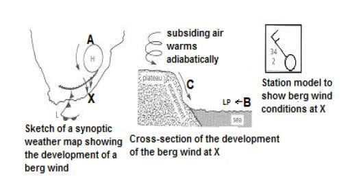
[Source: https://www.google.com/search?hl=development+of+berg+winds&oq=development+of+berg+winds&gs]
FIGURE 2.2: STAGES OF A RIVER 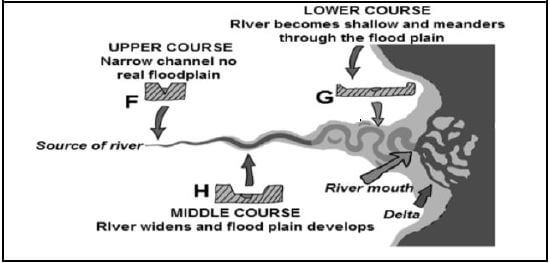
[Adapted from Profantasy'sMap-makingal©2010Profantasy’sSoftwareLtdDesignby Wellesley.]
FIGURE 2.3: URBAN TEMPERATURES 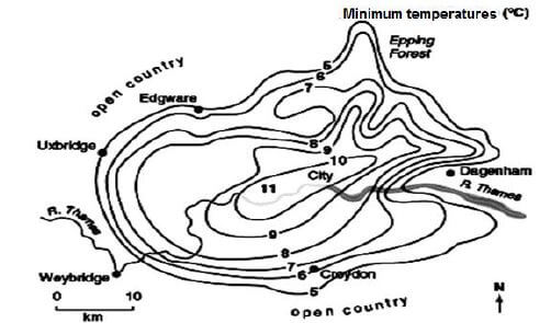
[Source: www.google.com/search?q=precipitation+urban]
FIGURE 2.4: INVERSION LAYER IN A VALLEY 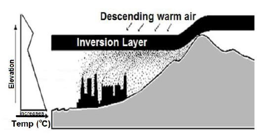
[Adapted from http//www.isuestate.ed/aber/mud/es/hith210/sonelight.htm]
FIGURE 2.5: RIVER CAPTURE 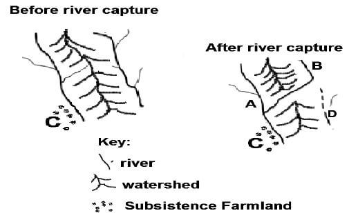
[Source: Examiners sketch – Not drawn to scale]
FIGURE 2.6: RIVER TERRACES 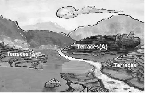
[Adapted by examiner from SA Geography-my school stuff]
FIGURE 3.2: URBANISATION AND URBAN GROWTH IN AFRICA 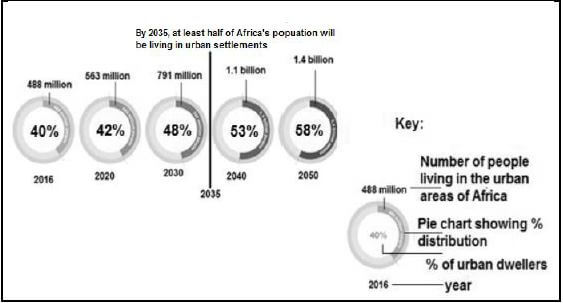
[Adapted by examiner from STATSSA]
FIGURE 3.3: A SETTLEMENT IN KWAZULU-NATAL 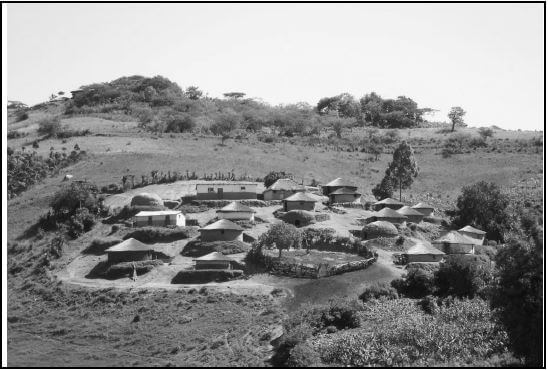
[Source: jpg. Traditional settlement in KZN]
FIGURE 3.4: MOVEMENT OF PEOPLE 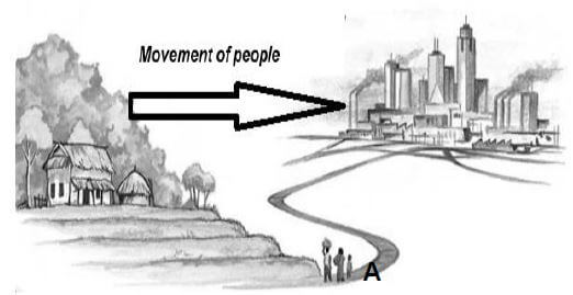
[Adapted from http//: www.Google images]
FIGURE 3.5: THE ORDER OF GOODS AND SERVICES IN THE CBD 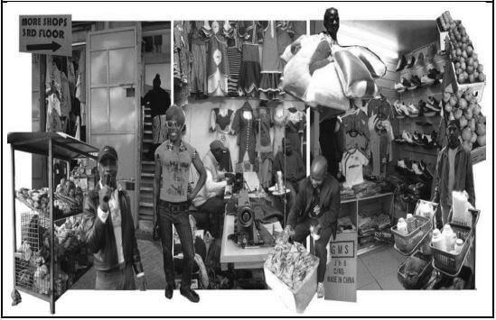
[Source: http:www.citylife.ergo/arv.traders/depot/street/goods]
FIGURE 3.6: ISSUES RELATED TO RAPID URBANISATION 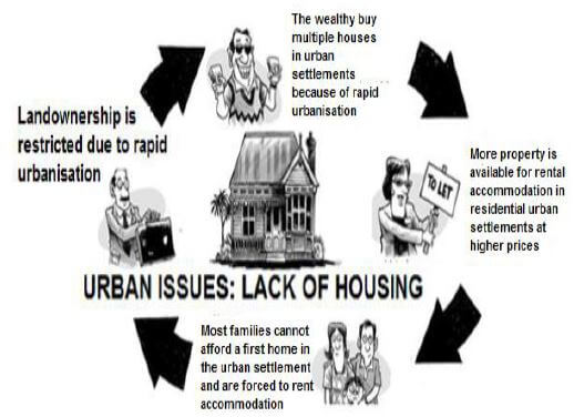
[Adapted by Examiner from Google, images]
GEOGRAPHY PAPER 2 GRADE 12 QUESTIONS - NSC EXAMS PAST PAPERS AND MEMOS JUNE 2019
GEOGRAPHY
PAPER 2
GRADE 12
NSC EXAMS
PAST PAPERS AND MEMOS JUNE 2019
RESOURCE MATERIAL
- An extract from topographic map 2527CA RUSTENBURG.
- Orthophoto map 2527CA 20 RUSTENBURG.
- NOTE: The resource material must be collected by schools for their own use.
INSTRUCTIONS AND INFORMATION
- Write your NAME in the space provided on the cover page.
- Answer ALL the questions in the spaces provided in this question paper.
- You are provided with a 1 : 50 000 topographic map (2527CA RUSTENBURG) and an orthophoto map (2527CA 20 RUSTERBURG) of a part of the mapped area.
- You must hand in the topographic map and the orthophoto map to the invigilator at the end of this examination session.
- You may use the blank page at the end of this question paper for all rough work and calculations. Do NOT detach this page from the question paper.
- Show ALL calculations and use the formulae provided, where applicable. Marks will be allocated for these.
- Indicate the unit of measurement in the final answer of calculations, e.g. 10 km; 2,1 cm.
- You may use a non-programmable calculator and a magnifying glass.
- The area demarcated in RED on the topographic map represents the area covered by the orthophoto map.
- The following English terms and their Afrikaans translations are shown on the topographic map:
ENGLISH |
|
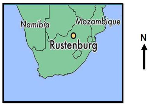
GENERAL INFORMATION ON RUSTENBERG Rustenburg City is a city at the foot of the Magaliesberg mountain range, located in the North West Province, South Africa and is the most rich and populous city in the Province.
[Source: https://en.wikipedia.org/wiki/Rustenburg] |
QUESTIONS
QUESTION 1: MULTIPLE-CHOICE QUESTIONS
The questions below are based on the 1 : 50 000 topographic map (2527CA RUSTENBURG) as well as the orthophoto map of the part of the mapped area. Various options are provided as possible answers to the following questions. Choose the answer and write only the letter (A–D) in the block next to each question.
1.1 The province in which Rustenburg is located is …
- Magaliesberg.
- Free State.
- North West.
- Mpumalanga.
1.2 Rustenburg mainly receives … rainfall.
- winter
- summer
- humid
- tropical
1.3 The map index/reference of the topographic map to the south-west of Rustenburg is …
- 2526DD.
- 2527CD.
- 2527CC.
- 2526DB.
1.4 The general direction of (N) in block A5 from (O) in block H8 on the topographic map is …
- south-east.
- north-east.
- north-west.
- south-west.
1.5 The Magaliesberg mountain range in blocks B1 and C2 on the topographic map forms a …
- mesa.
- ridge.
- pass.
- butte.
1.6 The value of the index contour line 10 on the orthophoto map is … metres.
- 1 215
- 1 205
- 1 200
- 1 210
1.7 The human-made features at 13 on the orthophoto map are …
- silos.
- tanks.
- reservoirs.
- towers.
1.8 The feature at 7 on the orthophoto map is …
- recreation ground.
- a swimming pool.
- sewage.
- a slime dam.
1.9 Features are larger on the orthophoto map than on the topographic map because the orthophoto map …
- has a larger scale.
- is bigger.
- covers a larger area.
- has a smaller scale.
1.10 The buildings at P (block G10) on the topographic map represent a …
- school.
- factory.
- shopping mall.
- hospital.
1.11 The stream order of the main stream enclosed by Q (block E3) on the topographic map is …
- 2.
- 3.
- 1.
- 4.
1.12 The dominant primary economic activity in the north-east of the mapped area is …
- orchard farming.
- mining.
- forestry.
- recreation.
1.13 The contour interval on the orthophoto map is … metres.
- 15
- 20
- 5
- 10
1.14 The land-use at 12 on the orthophoto map is …
- forestry.
- a golf course.
- residential.
- a cemetery.
1.15 The longitude of the spot height 1328 (block A3) is …
- 25° 33ʹ 40ʹʹ E
- 27° 07ʹ 40ʹʹ S
- 27° 07ʹ 25ʹʹ E
- 25° 05ʹ 25ʹʹ S (15 x 1) [15]
QUESTION 2: MAP CALCULATIONS AND TECHNIQUES
2.1 The orthophoto is referenced from the topographic map 2527CA 20 RUSTENBURG.
State what the following indicate in the index to sheet on the orthophoto map. 2.1.1
- CA: (2 x 1) (2)
- 20: (1 x 1) (1)
2.2 Calculate the magnetic bearing of spot height 1191 (block B7) from the trigonometrical station 29 (block B7) for the year 2019. Show ALL calculations. Marks will be awarded for calculations.
Formula: Magnetic bearing = True Bearing + Magnetic Declination (7 x 1) (7)
2.3 Refer to the blocks F2 and E4 on the topographic map.
2.3.1 Calculate the average gradient of the N4 road between G (block F2) and H (block E4) on the topographic map. Show ALL calculations. Marks will be awarded for calculations.
Formula: Gradient = Vertical Interval (VL) (5 x 1) (5)
Horizontal Equivalent (H.E)
2.3.2 Interpret the gradient calculated in QUESTION 2.3.1. (2 x 1) (2)
2.3.3 Is G visible from H? Give a reason for your answer.
- Answer:
- Reason: (1 + 1) (2)
2.4 Write the scale of the topographic map as a word scale. (1 x 1) (1) [20]
QUESTION 3: APPLICATION AND INTERPRETATION
3.1 Refer to the Dorpspruit River on the topographic and orthophoto maps to answer the questions below.
3.1.1 In which general direction is the Dorpspruit River flowing? Give TWO topographic or orthophoto evidence to support your answer.
- Answer: (1 x 1) (1)
- Reasons: (2 x 2) (4)
3.1.2 Is the Dorpspruit River between points 14 and 15 on the orthophoto map in the youth stage or mature stage? Give TWO orthophoto evidences to motivate your answer.
- Answer: (1 x 1) (1)
- Evidence: (2 x 2) (4)
3.2 The stadium numbered 1 on the orthophoto map has a good location. Provide TWO pieces of topographic and orthophoto evidence to support this statement. (2 x 2) (4)
3.3 Locate R (block H9) on the topographic map.
3.3.1 Identify the dominant street pattern within the vicinity of R. (1 x 1) (1)
3.3.2 Give ONE map evidence why the street pattern identified in QUESTION 3.3.1, was developed. Reason: (1 x 2) (2)
3.3.3 Why is the street pattern identified in QUESTION 3.3.1 not preferred by modern town planners? Reasons: (2 x 2) (4)
3.4 Find settlement S (block H1) on the topographic map.
3.4.1 Would you describe settlement S as a dry point or wet point settlement? Answer: (1 x 1) (1)
3.4.2 Explain your answer to QUESTION 3.4.1. (1 x 2) (2)
3.5 Generally, Rustenburg experiences relatively cool summers than expected. Give a reason for that. Answer: (1 x 1) (1) [25]
QUESTION 4: GEOGRAPHICAL INFORMATION SYSTEMS (GIS)
4.1 Provide a GIS concept for the following descriptions.
4.1.1 Data that can be linked to locations in geographical space, usually via features on the map.
4.1.2 A question, especially if asked to a database by the user via database management systems.
4.1.3 A map designed to show a single spatial distribution pattern, using a specific map type.
4.1.4 Characteristic of a feature that contains measurements of value for feature and is displayed as columns in table form.
4.1.5 The combination of two or more data layers to create a new one. (5 x 1) (5)
4.2 Refer to block J3 on the topographic map.
4.2.1 Name the type of vector data used to represent:
- Dam wall:
- Cultivated land: (2 x 1) (2)
4.2.2 Explain TWO reasons why GIS specialists prefer using vector data on topographic maps to raster data. (2 x 2) (4)
4.3 Refer to the extract part of block H1 on which mining of gravel is taking place. The scale of the extract has been exaggerated to 1 : 10 000.
[Source: Extract of part of block H1 (scale 1 : 10 000)]
4.3.1 The GIS specialist decides to buffer the excavation so that water quality in the dam and river can be maintained.
- Define the term buffering. (1 x 1) (1)
- Create a 100 m buffer around the excavation. Use the above extract to display the buffer. (1 + 2) (3) [15]
TOTAL: 75
GEOGRAPHY PAPER 1 GRADE 12 QUESTIONS - NSC EXAMS PAST PAPERS AND MEMOS JUNE 2019
GEOGRAPHY
PAPER 1
GRADE 12
NSC EXAMS
PAST PAPERS AND MEMOS JUNE 2019
INSTRUCTIONS AND INFORMATION
- This question paper consists of THREE questions.
- Answer ALL THREE questions of 75 marks each.
- All diagrams/sources are included in the ANNEXURE.
- Number the questions correctly according to the numbering system used in this question paper.
- Leave a line between subsections of questions answered.
- Start EACH question on a NEW page.
- Do NOT write in the margins of the ANSWER BOOK.
- Illustrate your answers with labelled diagrams, when asked to do so.
- Mark allocation is as follows: 2 x 1 = 2 means that TWO facts are required for ONE mark each 2 x 2 = 4 means that TWO facts are required for TWO marks each
- If words/action verbs like Name, Identify, Provide, Classify are used in a question, ONE-word answers are acceptable. If words/action verbs like Discuss, Define, Explain, Comment, Evaluate, Justify, Suggest and Substantiate are used in a question, FULL sentences or phrases are required. All paragraph questions must be answered in FULL sentences.
- Write neatly and legibly.
QUESTIONS
SECTION A: CLIMATE, WEATHER AND GEOMORPHOLOGY
QUESTION 1
1.1 Choose a term/concept from COLUMN B that matches the climatological description in COLUMN A. Write only the letter (A–I) next to the question number (1.1.1–1.1.8) for example 1.1.9 J.
| COLUMN A | COLUMN B |
| 1.1.1 An open space reserved for parks or recreation areas in a city to reduce temperatures 1.1.2 Receives names alphabetically as they occur 1.1.3 Dew point temperature drops below freezing point and this type precipitation occurs in thie lower part of the valley 1.1.4 A pressure system over the cold ocean to the west of South Africa 1.1.5 In a valley, settlements will mostly develop in this zone 1.1.6 Occurs during summer over the central interior 1.1.7 The angle of slopes in relation to the sun’s rays 1.1.8 The mass of polluted air above the city |
(8 x 1) (8) |
1.2 FIGURE 1.2 shows types of rivers. Match the labels below with the letters in FIGURE 1.2. Write only the letter (A–G) next to the question number (1.2.1–1.2.7), for example 1.2.8 H. Use each letter only once.
1.2.1 Water table during the dry season
1.2.2 Water table during the rainy season
1.2.3 Periodic river
1.2.4 Permanent river
1.2.5 Level of base flow
1.2.6 Groundwater zone
1.2.7 Watershed (7 x 1) (7)
1.3 Refer to FIGURE 1.3 based on a synoptic weather map, depicting a mid latitude cyclone.
1.3.1
- Identify the season represented by the synoptic map. (1 x 1) (1)
- Give TWO pieces of evidence to support your answer in QUESTION 1.3.1(a). (2 x 1) (2)
1.3.2 Refer to the mid-latitude cyclone at A.
- What determines the direction of movement of A? (1 x 1) (1)
- Comment on the influence of A on the air temperature and air pressure of Cape Town and Port Elizabeth. (3 x 2) (6)
1.3.3 Draw a cross-section of the stage of development from B to C. Your diagram must include an understanding of the air mass in front of and behind the front. (4 x 1) (4)
1.4 Study FIGURE 1.4 which shows a satellite image of a travelling disturbance.
1.4.1 Does the satellite image depict a coastal low or a line thunderstorm? (1 x 1) (1)
1.4.2 Name and describe the air masses at A and B respectively. (2 + 2) (4)
1.4.3 Refer to the front depicted on the satellite image.
- Provide the name of the front on the satellite image. (1 x 1) (1)
- Describe the movement of the air masses as they meet along the front mentioned in QUESTION 1.4.3(a). (2 x 1) (2)
1.4.4 In a paragraph of approximately EIGHT lines, describe the positive impact of the travelling disturbance identified in QUESTION 1.4.1 on the agriculture in the interior of South Africa. (4 x 2) (8)
1.5 Refer to FIGURE 1.5 which illustrates a drainage pattern and drainage density.
1.5.1 Name the drainage pattern depicted in FIGURE 1.5. (1 x 1) (1)
1.5.2 Provide TWO characteristics of this drainage pattern. (2 x 1) (2)
1.5.3 How will a rectangular drainage pattern differ from the pattern mentioned in QUESTION 1.5.1? (2 x 2) (4)
1.5.4 Refer to the drainage densities of the drainage patterns A and B.
- What is drainage density? (1 x 1) (1)
- Does drainage basin A or B have a higher drainage density? (1 x 1) (1)
- Name TWO ways in which the density of drainage basins can be determined. (2 x 1) (2)
- Explain how the underlying rock resistance may have influenced the difference in drainage density between A and B. (2 x 2) (4)
1.6 Refer to the CASE STUDY in FIGURE 1.6 on priority issues for catchment management in South Africa.
1.6.1 Name the international non-governmental organisation working with the South African government on catchment management programs. (1 x 1) (1)
1.6.2 Why is the preservation of wetlands so important in the management of catchment areas? (1 x 2) (2)
1.6.3 Provide TWO management programs from the case study that aim to improve catchment management. (2 x 2) (4)
1.6.4 In a paragraph of approximately EIGHT lines, propose sustainable strategies to the Department of Water Affairs, for the improvement in the supply and quality of water in South Africa. (4 x 2) (8) [75]
QUESTION 2
2.1 Refer to FIGURE 2.1 showing the development of a berg wind. Choose ONE term in brackets to make each of the following statements TRUE. Write only the correct word next to the number (2.1.1–2.1.7).
2.1.1 The pressure system labelled A is the (South Atlantic / Kalahari) High.
2.1.2 The circulation at A is associated with a spiralling (anticlockwise / clockwise) movement of air.
2.1.3 The low pressure system labelled B is a (coastal low / mid-latitude cyclone).
2.1.4 The wind direction at C is (north west / north east).
2.1.5 The type of weather system that forms after the berg wind, is a (tropical/ mid-latitude) cyclone.
2.1.6 The high temperature range experienced at station model X, is caused by (onshore / off shore) winds.
2.1.7 As the air descends down the plateau, it will warm up adiabatically at approximately (0,5 °C for each 100 m / 1 °C for each 100 m). (7 x 1) (7)
2.2 Refer to FIGURE 2.2. Various options are provided as possible answers to the following questions. Choose the correct answer and write only the letter (A–D) next to the question number (2.2.1–2.2.8), for example 2.2.9 D.
2.2.1 The ... represents the different stages of the river.
- longitudinal profile
- vertical profile
- cross-section profile
- top view
2.2.2 An oxbow lake is most likely to be present in the …
- middle course.
- lower course.
- medium course.
- upper course.
2.2.3 The cross sections F, G and H are best labelled as … courses respectively.
- lower, middle, upper
- lower, upper, middle
- upper, lower, middle
- middle, lower, upper
2.2.4 In the lower course of the river, the floodplain …
- erodes vertically.
- consists of deposited silt.
- is absent.
- increases in tributaries.
2.2.5 A delta is formed in the … course.
- upper
- middle
- medium
- lower
2.2.6 Increased velocity of flowing water within a meandering river will form an undercut bank in the … course.
- upper
- middle
- medium
- lower
2.2.7 The upper course usually has a … profile.
- convex
- smooth concave
- multi-concave
- terraced
2.2.8 A common fluvial landform in the lower course is …
- rapids.
- braided streams.
- knickpoint waterfalls.
- interlocking spurs. (8 x 1) (8)
2.3 Refer to FIGURE 2.3 showing lines that represent the temperatures of the city of London and surrounding areas.
2.3.1 Identify the lines depicted in FIGURE 2.3. (1 x 1) (1)
2.3.2 Calculate the difference in temperature between Edgware and the city. (1 x 1) (1)
2.3.3 What term is used to describe the high temperatures over the city? (1 x 1) (1)
2.3.4 Explain the reason for the use of the term mentioned in QUESTION 2.3.3. (1 x 2) (2)
2.3.5 Discuss THREE reasons for the occurrence of the climatic phenomenon mentioned in QUESTION 2.3.3. (3 x 2) (6)
2.3.6 Evaluate the impact of the R. Thames (river) on the temperatures of the city. (2 x 2) (4)
2.4 FIGURE 2.4 is a diagram showing an inversion layer affecting a valley.
2.4.1 What is a temperature inversion? (1 x 1) (1)
2.4.2 Name the type of precipitation that occurs when the trapped smoke and fog mixes. (1 x 2) (2)
2.4.3 Study the graph and comment on the changes in temperature with altitude. (2 x 2) (4)
2.4.4 In a paragraph of approximately EIGHT lines discuss how the inversion layer impacts on human activity in the valley. (4 x 2) (8)
2.5 Refer to FIGURE 2.5 which demonstrates the process of river capture.
2.5.1 What is river capture? (1 x 1) (1)
2.5.2 How would you describe the difference in topography (height) of the rivers at A and B? (1 + 1) (2)
2.5.3 Explain how the difference in topography (height) contributed to river capture. (2 x 2) (4)
2.5.4 Determine the positive impact of river capture on subsistence farming activities at C. (2 x 2) (4)
2.5.5 Explain the effect of river capture on the aquatic life of stream D. (2 x 2) (4)
2.6 Refer to FIGURE 2.6 showing river terraces along a river.
2.6.1 Are terraces associated with superimposed drainage patterns or antecedent drainage patterns? (1 x 1) (1)
2.6.2 Are terraces A paired or unpaired? (1 x 1) (1)
2.6.3 Give a reason for your answer to QUESTION 2.6.2. (1 x 1) (1)
2.6.4 Explain how river rejuvenation results in the formation of river terraces. (2 x 2) (4)
2.6.5 In a paragraph of approximately EIGHT lines, comment on the impact of river terraces on human activities. (4 x 2) (8) [75]
SECTION B: RURAL AND URBAN SETTLEMENTS
QUESTION 3
3.1 Choose a term from COLUMN B that matches the description in COLUMN A. Write only the letter (A–I) next to the question number (3.1.1–3.1.8), for example 3.1.9 J.
| COLUMN A | COLUMN B |
| 3.1.1 A grouping of people, activities, building structures and communication networks that function as a single integrated system 3.1.2 The distribution of buildings in a settlement in relation to each other, irrespective of the environment 3.1.3 The detailed appearance of an individual settlement with respect to its shape and arrangement of buildings 3.1.4 The exact physical land on which settlements are built 3.1.5 Where buildings are usually close to one another 3.1.6 The fundamental difference between a rural and an urban settlement 3.1.7 The place where lack of social life is a disadvantage for the inhabitants. 3.1.8 The relationship between a settlement and its immediate surroundings e.g. general relief or transport routes |
(8 x 1) (8) |
3.2 Study FIGURE 3.2, showing urbanisation and urban growth in Africa.
Various options are provided as possible answers to the following questions. Choose the answer and write only the letter (A–D) next to the question number (3.2.1–3.2.7) in the ANSWER BOOK, for example 3.2.8 A.
3.2.1 The process by which an increasing percentage of the total population is accommodated in the urban area is referred to as …
- urban growth.
- urban expansion.
- urbanisation.
- urban sprawl.
3.2.2 The percentage of the total population living in urban settlements at any given time is referred to as the …
- settlement percentile.
- rate of urbanisation.
- rate of depopulation.
- level of urbanisation.
3.2.3 The predicted increase in percentage of people living in the urban area between 2016 and 2040 is … %.
- 02
- 40
- 13
- 53
3.2.4 The total number of people living in urban areas in 2016 was … million people.
- 488
- 563
- 732
- 791
3.2.5 The current (2018) predicted population in Africa that are living in urban areas is approximately … million people.
- below 488
- above 563
- between 520 and 530
- 791
3.2.6 A major effect of urban growth that is likely to be experienced in 2050 will be a/an …
- shortage of housing.
- decrease in population.
- increase in food security.
- increase in biodiversity.
3.2.7 In which year will half of Africa’s population be living in rural areas?
- 2035
- 2020
- 2040
- 2050 (7 x 1) (7)
3.3 Refer to FIGURE 3.3, a photograph showing a settlement in KwaZulu-Natal.
3.3.1 Is the settlement in the photograph a rural or urban settlement? (1 x 1) (1)
3.3.2 State the pattern of distribution evident in this settlement. (1 x 1) (1)
3.3.3 Classify the settlement identified in QUESTION 3.3.1 according to its size/complexity. (1 x 1) (1)
3.3.4 Name and explain ONE physical factor that influenced the site of this settlement. (2 x 2) (4)
3.3.5 How has culture and tradition influenced the farming practices of this settlement? (2 x 2) (4)
3.3.6 Explain how the reduction of cultivated land would impact on the rate of rural depopulation in the depicted settlement. (2 x 2) (4)
3.4 Refer to FIGURE 3.4, illustrating a rural process.
3.4.1 Identify the process indicated by the Movement of people. (1 x 1) (1)
3.4.2 Name a possible social pull factor that may have caused this Movement of people. (1 x 1) (1)
3.4.3 Rural depopulation is a consequence of this process mentioned in QUESTION 3.4.1.
- Define the term rural depopulation. (1 x 1) (1)
- How will this depopulation affect local businesses in this area? (2 x 2) (4)
3.4.4 The family at A expect to have a better future by moving to the indicated area. In a paragraph of approximately EIGHT lines, discuss the positive impact on the future standard of living of this family. (4 x 2) (8)
3.5 Study FIGURE 3.5 which illustrates services offered in urban areas.
3.5.1 Using the photograph, name any TWO goods being sold in this market. (2 x 1) (2)
3.5.2 Determine if the goods being sold by traders are high order goods or low order goods. (1 x 1) (1)
3.5.3 Give a reason for your answer to QUESTION 3.5.2. (1 x 2) (2)
3.5.4 Why would the cost of goods (ANSWER to QUESTION 3.5.1) be low? (1 x 2) (2)
3.5.5 Comment on the threshold population for the type of goods being sold. (1 x 2) (2)
3.5.6 The goods being sold are mostly traded in the CBD. Why would determining a range for the goods be difficult? (3 x 2) (6)
3.6 Study FIGURE 3.6 on an issue related to rapid urbanisation.
3.6.1 Identify the issue related to rapid urbanisation. (1 x 1) (1)
3.6.2 What is the relationship between landownership in residential urban settlements and the wealthy? (1 x 2) (2)
3.6.3 Use the cartoon to suggest TWO probable (most likely) challenges experienced by families in residential urban settlements. (2 x 2) (4)
3.6.4 Write a paragraph of approximately EIGHT lines to discuss ways in which the Department of Human Settlements can improve the challenges (suggested in QUESTION 3.6.3) of rapid urbanisation in residential urban settlements. (4 x 2) (8) [75]
TOTAL: 225
GEOGRAPHY PAPER 1 GRADE 12 MEMORANDUM - NSC EXAMS PAST PAPERS AND MEMOS JUNE 2019
GEOGRAPHY
PAPER 1
GRADE 12
NSC EXAMS
PAST PAPERS AND MEMOS JUNE 2019
INSTRUCTIONS AND INFORMATION BEFORE COMMENCEMENT OF MARKING FOR INTERNAL AND EXTERNAL MODERATION PURPOSES.
- Use a single tick for the allocation of ONE (1) mark. ✓
- Use TWO ticks for the allocation of TWO (2) marks. ✓✓
- Ticks MUST be placed, on/on top of/at the end of the correct response, in the sentence.
- A cross (✗) MUST be placed at the end of each incorrect/invalid sentence or response.
- All paragraph questions must include the use of the symbol: M … when a candidate has achieved 8 marks.
(DO NOT allocate marks to candidates where paragraphs are not completed in full sentences.)
(DO NOT allocate marks where vague responses are given in paragraph responses that do not include an appropriate link to the responses in the Marking Guideline) - Each sub-section MUST have a total reflected on the right hand margin e.g. 1.1 should be a total out of (8) and 1.2 should be a total out of (7) and 1.3 should be a total out of (15).
- The sub total for each sub section must be CORRECTLY added to give you a TOTAL for the question, which must be written on the top left hand margin at the beginning of the answered question.
- The totals for each completed question MUST be written on the FRONT page with a GRAND TOTAL out of 225.
- Marking MUST be completed in RED pen.
- First level Moderation (HOD/Senior Teacher) MUST be completed in GREEN pen.
- Second level Moderation (Cluster/Circuit) MUST be completed in ORANGE pen.
- You are encouraged to engage with the Marking Guideline and ADD appropriate (valid) responses that may have been omitted during the development in consultation with your DISTRICT SUBJECT ADVISOR. For moderation purposes you are required to write these additions on your marking guideline in RED and include the amended marking guideline as part of the educator portfolio of evidence for external moderation purposes.
MEMORANDUM
SECTION A: CLIMATE, WEATHER AND GEOMORPHOLOGY
QUESTION 1
1.1
1.1.1 B (1)
1.1.2 E (1)
1.1.3 D (1)
1.1.4 A (1)
1.1.5 G (1)
1.1.6 I (1)
1.1.7 H (1)
1.1.8 C (1) (8 x 1) (8)
1.2
1.2.1 B (1) Accept
1.2.2 A (1)
1.2.3 D (1)
1.2.4 C (1)
1.2.5 E (1) Accept B
1.2.6 F (1)
1.2.7 G (1) (7 x 1) (7)
1.3
1.3.1
- Winter (1) (1 x 1) (1)
- The Kalahari High pressure cell is well developed on the map (1)
Cold fronts influencing the weather of Cape Town (1)
Generally clear skies over the interior due to dominance of the Kalahari High pressure (1)
(Any TWO) (2 x 1) (2)
1.3.2
- Driven by the westerly wind belt (1) (1 x 1) (1)
- Port Elizabeth is situated in the warm sector of the mid-latitude cyclone and Cape Town in the cold sector (2)
Therefore the temperature of Port Elizabeth is higher than that of Cape Town (2)
Colder air is heavier and denser than warmer air, therefore the air pressure of Cape Town is higher than that of Port Elizabeth (2) (3 x 2) (6)
1.3.3
[ANY FOUR LABELS MUST INCLUDE BOTH AIR MASSES] (4 x 1) (4)
1.4
1.4.1 Line thunderstorm (1) (1 x 1) (1)
1.4.2 Name:
- A = SW or cool/cold (dry) air mass (1)
- B = NE or warm, (moist) air mass (1)
Description:
- A = Cold air from Atlantic Ocean (1)
- B = warm air from Indian Ocean (1) (2 + 2) (4)
1.4.3
- Moisture front (1) (1 x 1) (1)
-
- The colder and denser air from the SW subsides (1)
- as there is undercutting (1)
- of the warmer, air from the NE (1)
OR - The warmer air is forced upwards by the cool air (1)
- resulting in currents of warm air masses and increased precipitation rates (1) [Any TWO] (2 x 1) (2)
1.4.4 POSITIVE ECONOMIC IMPACT ON AGRICULTURE OF INTERIOR
- Increases availability of rainwater/water to the central regions for agricultural practices of crop and stock farming (2)
- Increases profitability and economic activity of drier regions (2)
- Storage dams/dams reach capacity levels and water can be used for commercial and subsistence agricultural practices increasing agricultural outputs (2)
- Increased nutrients in soil due to improved soil fertility levels will improve agricultural crop yields and farming inputs/outputs (2)
- Increased rainfall has a purifying effect: Increased rainfall removes polluted water/diseases in farming areas from rivers/dams improving agricultural environments and stock quality and decreasing costs of maintenance of farms for farmers (2) [Any FOUR] (4 x 2) (8)
1.5
1.5.1 Dendritic (1) (1 x 1) (1)
1.5.2
- Resembles the branches of a tree (1)
- Tributaries join at acute angles (1)
- Underlying rock structure is uniform to resistance (1) [Any TWO] (2 x 1) (2)
1.5.3
- The main streams of a rectangular pattern bends at 90°/ the main stream of a dendritic pattern winds more gently (2)
- Tributaries join the main stream at 90° in a rectangular pattern/tributaries join the main stream at acute angles in a dendritic pattern (2)
- The rectangular pattern forms on joints and faults in igneous and sedimentary rocks/the dendritic pattern forms on igneous and sedimentary rocks with an equal resistance to erosion (2)
[Any TWO – Difference must be indicated to get full marks] (2 x 2) (4)
1.5.4
- Amount of streams in a river system (1) (Concept) (1 x 1) (1)
- A (1) (1 x 1) (1)
- Area of the drainage basin divided by the total length of all the streams (1)
Determining the stream order (1) (2 x 1) (2) - The rocks at A are generally softer than the rocks at B, therefore vertical erosion is easier, creating more channels (2)
The harder rocks of B, cause fewer channels and therefore lower density is the result (2) (2 x 2) (4)
1.6
1.6.1 WWF/World Wide Fund for nature (1) (1 x 1) (1)
1.6.2
- Wetlands naturally purify water (2)
- Wetlands reduce the risk of flooding (2)
[Any ONE] (1 x 2) (2)
1.6.3
- ‘Working for Water’(2)
- ‘Working for Wetlands’ (2)
- The control of water-thirsty alien plant infestations and wetland restoration (2)
[Any TWO] (2 x 2) (4)
1.6.4 IMPROVING THE QUALITY OF WATER SUPPLY:
- Build dams to ensure permanent and controlled water supply to communities (2)
- Manage river systems by improving flood controls and improving water volumes (2)
- Settlements can be encouraged to remove alien vegetation (2)
- Reduce the number of settlements built on the floodplain, to improve infiltration rates in gentle gradients (2)
- Increased buffering around the river to limit human impacts (2)
- The removal of groundwater/water for irrigation, mines and industries must be researched to ensure limits in pollution and usage (2)
- Inter-basin transfers of water – move water from one river basin to another (2)
- Artificial levees to keep water in the river and prevent loss of water through flooding (2)
- Clearing the river basin of exotic trees/tree species by local environmental groups (2)
- Buffer zones to prevent settlements near rivers as it contributes to water pollution (2)
- Manage the informal settlements near rivers to prevent domestic and sewage pollution in the water (2)
- Strict laws against industries polluting rivers (2)
- Heavy fines must be implemented to prevent water pollution (2)
- Conserve wet lands as they serve as sponges (2)
- GIS can be used to research the influence of mining, industries, settlements etc. on the drainage basin/catchment area (2)
- Water treatment works established to purify waste water before entering streams/rivers (2)
- More awareness and education campaigns for communities living close to the river (2)
- Increasing the access of communities to landfill sites and dump sites for improved waste disposal (2)
- Use local community schools to initiate clean up campaigns (2)
[Any FOUR] (4 x 2) (8) [75]
QUESTION 2
2.1
2.1.1 Kalahari High (1)
2.1.2 Anticlockwise (1)
2.1.3 Coastal low (1)
2.1.4 North west (1)
2.1.5 Mid-latitude cyclone (1)
2.1.6 Off shore (1)
2.1.7 1 °C/100 m (1) (7 x 1) (7)
2.2
2.2.1 D (top view) (1)
2.2.2 B (lower course) (1)
2.2.3 C (upper; lower; middle) (1)
2.2.4 B (consists of deposited silt) (1)
2.2.5 D (lower) (1)
2.2.6 B (middle) (1)
2.2.7 C (multi-concave) (1)
2.2.8 B (braided streams) (1) (8 x 1) (8)
2.3
2.3.1 Isotherms (1) (1 x 1) (1)
2.3.2 11 – 5 = 6°C (1) (1 x 1) (1)
2.3.3 Heat Island (1) (1 x 1) (1)
2.3.4
- The temperature of the city is higher than that of the open country (2)
- The temperature is approximately 6°C lower in the open country which surrounds the city (2)
[Any ONE] (1 x 2) (2)
2.3.5
- The city area has more artificial surfaces that absorb heat (2)
- There are more activities in the city that artificially generate heat (2)
- Higher buildings in the city trap heat and keep it between them (2)
- Drainage systems channel water away, therefore there is less insolation needed for evaporation, hence a surplus of heat is created (2)
(NOTE: ONE EXAMPLE OF EACH OF THE UNDELINED FACTS MAY BE ACCEPTED)
[Any THREE] (3 x 2) (6)
2.3.6
- The river will have a moderating influence (2)
- Some insolation will be used for evaporation, therefore more precipitation and cooling of the city (2)
- All places immediately next to the river will have lower temperatures than those further away (2)
[Any TWO] (2 x 2) (4)
2.4
2.4.1 When an area experiences a temperature increase with an increase in height (1) [Concept] (1 x 1) (1)
2.4.2 Smog (2) (1 x 2) (2)
2.4.3
- The graph indicates that at first the temperature decreased with altitude (2)
- The temperature increased with the increase in altitude after the inversion layer (2) (2 x 2) (4)
2.4.4 IMPACT ON THE VALLEY
- The smog/pollution is trapped by the inversion layer which causes visibility problems for humans (2)
- The pollutants are trapped by the sinking/descending air at night which causes skin irritation / lung problems etc.(2)
- The cold air displaced the warm air on the valley floor which can result in frost pockets forming hence affecting farming activities (2)
- The inversion layer is warm and settlements are often built in this belt (2) Crops/plants that are not frost resistant can be planted in this layer (2) [Any FOUR] (4 x 2) (8)
2.5
2.5.1
- A powerful river cuts back at its source and captures the headwaters of a neighbouring river (1)
- When a river flowing at a lower level captures a river flowing at a higher level (1)
[Any ONE] (1 x 1) (1)
2.5.2
- A – Lower (1)
- B – Higher (1) (2 x 1) (2)
2.5.3
- Stream A will erode headwardly through the watershed towards stream B because it is lower lying (2)
- The steeper gradient over which stream A flows causes it to cut back into the watershed (2)
- The valley through which stream A flows is deeper than the valley at stream B causing stream A to cut back into the watershed (2)
[Any TWO] (2 x 2) (4)
2.5.4
- The subsistence farmers at E would have a greater volume of water (2)
- Improved water supply will increase production levels and improve crop yields (2)
- Subsistence farming can change to small scale farming production due to increased harvests (2)
[Any TWO] (2 x 2) (4)
2.5.5
- The aquatic life will decrease (2)
- Excess silting will limit habitat of aquatic life (2)
- Biodiversity will decrease (2)
[Any TWO] (2 x 2) (4)
2.6
2.6.1 Superimposed drainage patterns (1) (1 x 1) (1)
2.6.2 Paired (1) (1 x 1) (1)
2.6.3 Terraces occur on both sides of the river system (1) (1 x 1) (1)
2.6.4
- Because of an increase of the river energy, the river is rejuvenated (2)
- Vertical erosion occurs (2)
- A new valley is carved into the old floodplain (2)
- If this process repeats itself, it will produce topographic steps that will result in the terrace(s) (2)
[Any TWO] (2 x 2) (4)
2.6.5 POSITIVE
- A river terrace is a tourist attraction (2)
- The tread of the terrace is large enough for the growing of crops (2)
- The area is too high to get flooded should the water level rise (2)
- The tread of the terrace consists of sediment that was deposited during flooding in the past (2)
- The sediment provides fertile soil for agricultural activity (2)
NEGATIVE
- Can result in increased runoff and destruction of vegetation (2)
- Not suitable for construction (2)
- Irrigation will be needed as the water will not reach the fields (2)
- It will be difficult for the farmers to reach the cultivated lands (2)
- Erosion could undercut the terraces, resulting in the collapse of the terraces (2)
- Erosion due to rain could occur on the scarp of the terrace (2)
[Any TWO] (4 x 2) (8) [75]
SECTION B: RURAL AND URBAN SETTLEMENTS
QUESTION 3
3.1
3.1.1 F (settlement) (1)
3.1.2 A (pattern) (1)
3.1.3 C (internal structure) (1)
3.1.4 E (site) (1)
3.1.5 D (nucleated) (1)
3.1.6 B (function) (1)
3.1.7 I (dispersed) (1)
3.1.8 G (situation) (1) (8 x 1) (8)
3.2
3.2.1 C (1)
3.2.2 D (1)
3.2.3 C (1)
3.2.4 A (1)
3.2.5 C (1)
3.2.6 A (1)
3.2.7 A (1) (7 x 1) (7)
3.3
3.3.1 rural (1) (1 x 1) (1)
3.3.2 nucleated (1) (1 x 1) (1)
3.3.3 Hamlet (1)
[Accept rural hamlet] (1 x 1) (1)
3.3.4
- Arable land (2)
- The soil is fertile and promotes the growth of crops (2)
- Pasturage (2) The location enables the growth of a pasturage for livestock in the centre of the hamlet (2)
- Fuel (2) The location of woodlands and trees around the settlement increases the availability of wood for heating (2)
- Dry point (2) Settlement can be located on a slope above the flood level (2)
- Aspect (2) The buildings are located on the middle slopes to improve the amount of heat received (2)
[Any ONE with explanation] (2 x 2) (4)
3.3.5
- Collective land ownership – A belief system of agricultural activities within a single patriarchy and siblings (One family with buildings in close proximity to each other) (2)
- Shared farming practices – Farmers with similar religious and belief systems group together to share farming implements and methods (2)
- Traditional cattle farming communities believed to keep the holdings for livestock at the centre with buildings surrounding the cattle farming as the main activity (2)
[Any TWO] (2 x 2) (4)
3.3.6
- Reduction of cultivated land would increases the rate of rural depopulation (2)
- Soil becomes infertile and uneconomical to continue agricultural practices leading to abandoned farms and villages (2) (2 x 2) (4)
3.4
3.4.1 Rural-urban migration (1 x 1) (1)
3.4.2
- Better services in urban areas (water, power, accept other examples) (1)
- Better facilities in urban areas (schools, clinics, accept other examples) (1)
- ‘Bright lights’ (1) (cinemas, clubs, accept other examples)
[Any ONE] (1 x 1) (1)
3.4.3
- Decrease in people living in rural areas (1) (Concept) (1 x 1) (1)
-
- Businesses will have a significant drop in clientele (2)
- Small scale businesses will close down (2)
- No upgrading of infrastructure by local authorities because of poor local finances (2)
- Elderly and young with low buying power left behind (2)
[Any TWO] (2 x 2) (4)
3.4.4
- Possibility of finding secure employment (2)
- Family will have regular and consistent income (2)
- Better services like housing, medical, education, etc. (2)
- Possibility of better recreational and cultural activities (2)
- Being able to afford basic needs and beyond will alleviate poverty (2)
- Better education will have a positive effect on the children’s future possibilities (2)
[Any FOUR] (4 x 2) (8)
3.5
3.5.1
- Vegetables/cucumbers/lettuce/carrots/tomatoes (1)
- Traditional cloth/clothing/garments (1)
- Food/Pies/Samoosas (1)
- Traditional drinks (1)
- Pillows (1)
- Cushions (1)
- Shoes (1)
- Fruits/Pears/Apples (1)
[Any TWO] (2 x 1) (2)
3.5.2 Low order goods (1) (1 x 1) (1)
3.5.3 Goods are obtained at lower prices/easily obtained (2) (1 x 2) (2)
3.5.4
- The items are daily items and services which will be lower priced and are available and purchased by both regular and irregular patrons in the CBD (2)
- Each business will sell cheaper goods to operate with a lower profit margin with improved volumes as the threshold population is not constant (2)
- The type of customers (threshold population) would seek informal traders as their pricing on goods and services will be lower (2)
[Any ONE] (1 x 2) (2)
3.5.5 A low threshold population is required for the goods and services provided (2) (1 x 2) (2)
3.5.6
- The price of goods does not depend on distance (2)
- The potential for customers increases because the CBD is a centrally placed location (2)
- The central location ensures that the business is visited regularly by customers with a variation in distances (2)
- The radius from the centre extends in all directions increasing the sphere of influence (2)
[Any THREE] (3 x 2) (6)
3.6
3.6.1 Lack of housing (1) (1 x 1) (1)
3.6.2 Most of the land held in residential urban settlements is owned by the wealthy (2) (1 x 2) (2)
3.6.3 Challenge 1
- Most families cannot afford to buy property in residential urban settlements (2)
Challenge 2
- Most families are forced to rent property at higher prices in residential urban settlements (2) (2 x 2) (4)
3.6.4
- Closer monitoring of ownership patterns in residential urban settlements by estate agents and the wealthy (2)
- Maximum number of property ownership (restrictions of ownership) within communities (2)
- Different costing structures for wealthy and powerful owners (2)
- Appropriate land use planning policies that integrate affordability on the outskirts of the CBD to solve some lack of housing challenges (2)
- Rental controls to limit profitability margins and improve availability of housing (2)
- Property gains taxes to the wealthy (2)
- Restricted areas for council approved housing to reduce the impact of a lack of living space (2)
[Any FOUR] (4 x 2) (8) [75]
TOTAL: 225
GEOGRAPHY PAPER 2 GRADE 12 MEMORANDUM - NSC EXAMS PAST PAPERS AND MEMOS JUNE 2019
GEOGRAPHY
PAPER 2
GRADE 12
NSC EXAMS
PAST PAPERS AND MEMOS JUNE 2019
MEMORANDUM
QUESTION 1: MULTIPLE-CHOICE QUESTIONS
The questions below are based on the 1 : 50 000 topographic map (2527CA RUSTERNBURG) as well as the orthophoto map of the part of the mapped area. Various options are provided as possible answers to the following questions. Choose the answer and write only the letter (A–D) in the block next to each question.
1.1 C
1.2 B
1.3 A
1.4 C
1.5 B
1.6 C
1.7 B
1.8 D
1.9 A
1.10 C
1.11 A
1.12 B
1.13 C
1.14 B
1.15 C (15 × 1) [15]
QUESTION 2: MAP CALCULATIONS AND TECHNIQUES
2.1 The orthophoto is referenced from the topographic map 2527CA 20 RUSTENBURG. State what the following indicate in the index sheet on the orthophoto map.
2.1.1
- CA:
C is the big block (3rd of 4th blocks)✓
A is the small block (1st of small blocks found in big block C)✓ (2 x 1) (2) - 20:
20 is the exact orthophoto map sheet of the 25 that make up the 1 : 50 000 topographic maps ✓ (1 x 1) (1)
2.2 Calculate the magnetic bearing of spot height 1191 (block B7) from the trigonometrical station 29 (block B7) for the year 2019. Show ALL calculations. Marks will be awarded for calculations.
- Formula: Magnetic bearing = True bearing + Magnetic Declination
TB = 247° ✓ (range 245° – 249°)
Magnetic declination for 2019
Difference in years: 2019 – 1997 = 22 ✓ years
Mean annual change: 2ʹ ✓ W
Total change: 22 years x 2ʹ = 44ʹ ✓
Mean mag. declination for 2019: 15° 57ʹ W + ✓ 44ʹ = 16° 41ʹ W ✓
Therefore mag. bearing for 2019: 247° + 16° 41ʹ = 263° 41ʹ ✓
Range (261° 41ʹ – 265° 41ʹ) (7 x 1) (7)
2.3 Refer to the blocks F2 and E4 on the topographic map.
2.3.1 Calculate the average gradient of the N4 road between G (block F2) and H (block E4) on the topographic map.
Show ALL calculations. Marks will be awarded for calculations.
Formula: Gradient = Vertical Interval (V.I)
Horizontal Equivalent (H.E)
- VI = 1298,5 – 1 235,4 = 63,1 ✓ m
HE = 6,6 ✓ cm (range 6,5 – 6,7) cm
HE: 6,6 x 500 = 3 300 ✓m (range 3 250 – 3 350)
G = (63.1)1 OR [63.1 : 3300]
3300 [63.1 63 ]
1/52,3 or 1: 52,3 ✓ (range: 1: 51,5 to 1: 53,1) (5 x 1) (5)
2.3.2 Interpret the gradient calculated in QUESTION 2.3.1.
- For every 52,3 m travelled along the ground, ✓ the height increases by 1 m. ✓ (concept) (2 x 1) (2)
2.3.3 Is G visible from H? Give a reason for your answer.
- Answer: No ✓
- Reason: There is Magaliesberg Mt. range in between G and H ✓ Higher feature between G and H ✓ [Any ONE] (1 + 1) (2)
2.4 Write the scale of the topographic map as a word scale.
- Scale: (1 : 50 000) 1 centimetre on the map represents 50 000 centimetres on the actual ground. ✓
(Units of measurements must be the same to get a full mark.) (1 x 1) (1) [20]
QUESTION 3: APPLICATION AND INTERPRETATION
3.1 Refer to the Dorpspruit River on the topographic and orthophoto maps to answer the questions below.
3.1.1 In which general direction is the Dorpspruit River flowing? Give TWO topographic or orthophoto evidence to support your answer.
- Answer: NE/NNE ✓ (1 x 1) (1)
- Reasons:
- Contour lines are facing NE (orthophoto map) ✓✓
- Dam wall is the NE part of the river (topographic map) ✓✓
- Water is held behind the dam wall in the SE direction. ✓✓
- The non-perennial tributaries in blocks I8 and H9 joins the Dorpspruit river at an acute/small angle from the SW ✓✓
[ANY TWO] (2 x 2) (4)
3.1.2 Is the Dorpspruit river between points 14 and 15 on the orthophoto map in the youth stage or mature stage? Give TWO orthophoto evidences to motivate your answer.
- Answer: Mature stage ✓ (1 x 1) (1)
- Evidence:
- Contour lines are widely spaced out – gentle slope ✓✓
- Valley is an open v-shaped with gentler slope ✓✓
- River begins to meander near point 15 ✓✓
- The river is wider from point 15 to point 14 ✓✓
[Any TWO] (4) (2 x 2)
3.2 The stadium numbered 1 on the orthophoto map has a good location. Provide TWO pieces of topographic and orthophoto evidence to support this statement.
- Flat land – contour lines are far apart ✓✓
- Location is accessible – near N4 and other roads ✓✓
- Located between the low and high-income residential areas ✓✓
- Large population for support base ✓✓ [Any TWO] (2 x 2) (4)
3.3 Locate R (block H9) on the topographic map.
3.3.1 Identify the dominant street pattern within the vicinity of R.
- Grid iron ✓ (1 x 1) (1)
3.3.2 Give ONE map evidence why the street pattern identified in QUESTION 3.3.1 was developed.
- Reason: Due to flat land/relief (contour lines are far apart) ✓✓ (1 x 2) (2)
3.3.3 Why is the street pattern identified in QUESTION 3.3.1, not preferred by modern town planners? Reasons:
- Hampers traffic flow because it has too many stops / many intersections which halt the flow of traffic (gridlock) ✓✓
- Accidents and traffic congestion may occur ✓✓ (2 x 2) (4)
3.4 Find settlement S (block H1) on the topographic map.
3.4.1 Would you describe settlement S as a dry point or wet point settlement?
- Answer: Wet-point settlement ✓ (1 x 1) (1)
3.4.2 Explain your answer to QUESTION 3.4.1.
- The settlement is close to a dam ✓✓
- a non- perennial river ✓✓ (1 x 2) (2)
3.5 Generally, Rustenburg experiences relatively cool summers than expected. Give a reason for that.
- Answer: This is due to higher altitude ✓ (1 x 1) (1) [25]
QUESTION 4: GEOGRAPHICAL INFORMATION SYSTEMS(GIS)
4.1 Provide a GIS concept for the following descriptions.
4.1.1 Data that can be linked to locations in geographical space, usually via features on the map.
- Spatial data ✓
4.1.2 A question, especially if asked to a database by the user via database management systems
- Query ✓
4.1.3 A map designed to show a single spatial distribution pattern, using a specific map type.
- Thematic map ✓
4.1.4 Characteristic of a feature that contains measurements of value for feature and is displayed as columns in a table form.
- Attribute/attribute data ✓
4.1.5 The combination of two or more data layers to create a new one.
- Data integration ✓ (5 x 1) (5)
4.2 Refer to block J3 on the topographic map.
4.2.1 Name the type of vector data used to represent:
- Dam wall: Line ✓
- Cultivated land: Polygon/areal data ✓ (2 x 1) (2)
4.2.2 Explain TWO reasons why GIS specialists prefer using vector data on topographic maps to raster data.
- The use of vector data on topographic map makes map interpretation more user friendly ✓✓
- It is easier to obtain data at a glance/quick referencing It makes it easier for data layering ✓✓
- Data can be rendered at any scale, as symbols are not drawn to scale ✓✓
- Zooming in and out does not change the quality of the topographic data representation ✓✓ [Any TWO] (2 x 2) (4)
4.3 Refer to the extract part of block H1 on which mining of gravel is taking place. The scale of the extract has been exaggerated to 1 : 10 000.
[Source: Extract part of block H1 (scale 1 : 10 000)]
4.3.1 The GIS specialist decides to buffer the excavation so that water quality in the dam and river can be maintained.
- Define the term buffering. It is the demarcation/boundary/delineation/spatial distance of an area around a feature ✓ (1 x 1) (1)
- Create a 100 m buffer around the excavation. Use the above extract to display the buffer.
- Shape (circular) around excavation ✓ (1)
- Correct distance from excavation to boundary (1 cm)✓✓ (2)
(1 mark for not having correct distance – only shape) (1 + 2) (3) [15]
TOTAL: 75
ECONOMICS PAPER 1 GRADE 12 QUESTIONS - NSC EXAMS PAST PAPERS AND MEMOS JUNE 2019
ECONOMICS
PAPER 1
GRADE 12
NSC EXAMS
PAST PAPERS AND MEMOS JUNE 2019
INSTRUCTIONS AND INFORMATION
- Answer FOUR questions as follows in the ANSWER BOOK:
- SECTION A: COMPULSORY
- SECTION B: Answer TWO of the three questions.
- SECTION C: Answer ONE of the two questions.
- Number the answers correctly according to the numbering system used in this question paper.
- Write the number of the question above each answer.
- Read the questions carefully and start each question on a NEW page.
- Leave 2–3 lines between subsections of questions.
- Answer the questions in full sentences and ensure that the format, content and context of your responses comply with the cognitive requirements of the questions.
- Answer only the required number of questions. Answers in excess of the required number will NOT be marked.
- Use only blue or black ink.
- You may use a non-programmable pocket calculator.
- Write neatly and legibly.
QUESTIONS
SECTION A (COMPULSORY)
QUESTION 1
1.1 Various options are provided as possible answers to the following questions. Choose the correct answer and write only the letter (A–D) next to the question number (1.1.1–1.1.8) in the ANSWER BOOK, for example 1.1.9 D.
1.1.1 To enjoy the advantages of efficient markets, countries should rely on the principle of ... advantage.
- competitive
- convenient
- comparative
- relative
1.1.2 Goods which are regarded as socially harmful are known as ... goods.
- merit
- demerit
- capital
- public
1.1.3 The banks are allowed by the SARB to occasionally change the minimum cash balance. This is known as …
- interest rate
- moral suasion
- cash reserve requirement
- open market transactions
1.1.4 When the demand is low and unemployment high, the government can ...
- decrease taxes.
- decrease government spending.
- decrease government spending and decreasing taxes.
- increase taxes.
1.1.5 Countries with fundamental balance of payments problems can apply for financial support from the ...
- International Monetary Fund.
- Federal Bank.
- World Bank.
- Reserve Bank.
1.1.6 Goods of which there is a complete supply or none, e.g. defence is called ... goods.
- collective
- public
- private
- community
1.1.7 Which ONE of the following can cause a deficit on the balance of payments?
- Inward foreign investments
- Increase in foreign currency reserves
- Decline in mineral exports
- Increase in exports
1.1.8 Economic integration where member countries agree on a common foreign economic policy is called a ...
- free-trade area.
- customs union.
- common market.
- economic union. (8 x 2) (16)
1.2 Choose a description from COLUMN B that matches the item in COLUMN A. Write only the letter (A–I) next to the question number (1.2.1–1.2.8) in the ANSWER BOOK, for example 1.2.9 K.
| COLUMN A | COLUMN B |
| 1.2.1 Economic growth 1.2.2 Bureaucrat 1.2.3 Monetary policy 1.2.4 Economic equity 1.2.5 Real business cycle 1.2.6 Globalisation 1.2.7 Free floating 1.2.8 Disequilibrium |
(8 x 1) (8) |
1.3 Give ONE term for each of the following descriptions. Write only the term next to the question number (1.3.1–1.3.6) in the ANSWER BOOK. Acronyms and abbreviations will NOT be accepted.
1.3.1 A document showing anticipated revenue and estimated expenditure.
1.3.2 A deliberate increase in the value of a currency.
1.3.3 A phase associated with increased profits in the business cycle.
1.3.4 This is paid to producers to reduce the costs of production and encourage the production of goods and services.
1.3.5 A financing instrument distributed among countries of the International Monetary Fund.
1.3.6 A minimum level of consumption that takes place even if the consumer has no disposable income. (6 x 1) (6)
TOTAL SECTION A: 30
SECTION B
Answer any TWO of the three questions in this section in the ANSWER BOOK.
QUESTION 2: MACROECONOMICS 40 MARKS – 30 MINUTES
2.1 Answer the following questions:
2.1.1 Name TWO demand reasons for international trade. (2 x 1) (2)
2.1.2 Why does the government levy high taxes on demerit goods? (1 x 2) (2)
2.2 Study the cartoon below and answer the questions that follow.
Producers and consumers are free to buy goods and services from anywhere in the world, without the interference of government. Regionalisation, in the form of trade blocs, makes use of free trade and protection with one another. Member countries pursue free trade with one another but apply trade restrictions outside their bloc e.g. NAFTA and Mercusor. 
2.2.1 Which trade policy is referred to in the above cartoon? (1)
2.2.2 Name any member country of the Mercusor trade bloc. (1)
2.2.3 Describe the term free trade. (2)
2.2.4 Briefly explain innovation as an argument in favour of free trade. (2)
2.2.5 How will protection of natural resources favour local industries? (2 x 2) (4)
2.3 Study the table below and answer the questions that follow.
NATIONAL ACCOUNTS IN Rbn
At current prices | 2016 |
Primary sector | 371 268 |
Agriculture, forestry and fishing | 84 662 |
Mining and quarrying | 286 606 |
Secondary sector | (A) |
Manufacturing | 452 326 |
Electricity, gas and water | 125 377 |
Construction | 138 917 |
Tertiary sector | 2 316 605 |
Gross value added at basic prices | 340 4493 |
2.3.1 Name the method used to calculate GVA in the above table. (1)
2.3.2 Name any activity that falls under the tertiary sector. (1)
2.3.3 Briefly describe the term GVA at constant prices. (2)
2.3.4 Calculate the contribution of the secondary sector (A). Show all calculations. (2)
2.3.5 Highlight the importance of the national account aggregates. (2 x 2) (4)
2.4 Differentiate between endogenous and exogenous reasons. (4 x 2) (8)
2.5 How will corruption impact negatively on the efficiency of the government? (8) [40]
QUESTION 3: ECONOMIC PURSUITS 40 MARKS – 30 MINUTES
3.1 Answer the following questions.
3.1.1 Give TWO examples of leakages. (2 x 1) (2)
3.1.2 What effect will ad valorem tariffs have on luxury items? (1 x 2) (2)
3.2 Study the graph below and answer questions that follow.
BUSINESS CYCLE 
3.2.1 How long does a Juglar cycle last? (1)
3.2.2 What is the slope of the trendline in the above graph? (1)
3.2.3 Describe the term composite indicator. (2)
3.2.4 Explain briefly the government’s aim with business cycle policies. (2)
3.2.5 How can the length be used in forecasting of business cycles? (2 x 2) (4)
3.3 Read the extract below and answer the questions that follow.
Eskom CEO Phakamani Hadebe says that 2018 has been a challenging year for the power utility and the clean-up process has been time consuming, but necessary. Eskom says there is no quick fix to dealing with its myriad of problems following years of corruption, but it remains optimistic that with time, it can get on top of its challenges. Eskom is in a dire financial situation and needs over R70 billion to meet its financial obligations. [Source: NEWS 24]
3.3.1 Which body regulates the supply of electricity in South Africa? (1)
3.3.2 Name ONE problem that the power utility has been faced with for years. (1)
3.3.3 Describe the term parastatals. (2)
3.3.4 Briefly explain ineffectiveness as a characteristic of public sector failure. (2)
3.3.5 How can the South African government address the lack of accountability? (2 x 2) (4)
3.4 Discuss goal bound and demand biased as features of the fiscal policy. (4 x 2) (8)
3.5 How can open market transactions be used to smooth out business cycles? (8) [40]
QUESTION 4: MACROECONOMICS AND ECONOMIC PURSUITS 40 MARKS – 30 MINUTES
4.1 Answer the following questions.
4.1.1 Name TWO arguments in favour of privatisation. (2 x 1) (2)
4.1.2 How will the SARB correct an overvalued rand? (1 x 2) (2)
4.2 Study the table below and answer the questions that follow.
BALANCE OF PAYMENT
| R BILLIONS | |||
Current Account | 2016 | 2017 | 2018 |
Merchandise exports | 1074 | 1089 | 1056 |
Net gold exports | 50 | 68 | 77 |
Merchandise imports | 1066 | 1106 | 1158 |
Trade balance | 58 | 51 | -25 |
Net service, income and current transfer payments | -150 | -181 | -204 |
Balance on the current account | -92 | -130 | -229 |
[Adapted from SARB QB, June 2018]
4.2.1 Why is gold listed as a separate item on the current account? (1)
4.2.2 What trend is shown by the current account from 2016 to 2018? (1)
4.2.3 Briefly describe the term trade balance. (2)
4.2.4 Explain the purpose of the current account. (2)
4.2.5 How can the government use our currency to improve the trade balance? (2 x 2) (4)
4.3 Read the extract and answer the questions that follow.
VAT INCREASE !!! The Minister of Finance announced in his Budget speech that the VAT rate will increase by 1% to 15 % with effect from 1st April 2018. This is expected to raise additional revenue of 22 billion. [Adapted from News24, 23 February 2018] |
4.3.1 Name ONE example of an indirect tax. (1) 4.3.2 What is the meaning of personal income tax relief? (1)
4.3.3 What impact will an increase in the VAT rate have on the standard of living of the poor? (2)
4.3.4 Briefly describe the projects the government will engage in with the revenue collected. (2)
4.3.5 How do reduced tax rates contribute to increased government revenue? (2 x 2) (4)
4.4 Briefly explain the measures that can be applied to reduce a deficit on the balance of payments. (4x2) (8)
4.5 Why is the promotion of employment and prevention of dumping important to protect developing countries against overseas competition? (8) [40]
TOTAL SECTION B: 80
SECTION C
Answer any ONE question of the TWO questions in the ANSWER BOOK. Your answer will be assessed as follows:
STRUCTURE OF ESSAY | MARK ALLOCATION |
Introduction
| Max. 2 |
Body
Additional part:
| Max. 26 Max. 10 |
Conclusion
| Max. 2 |
TOTAL | 40 |
QUESTION 5: MACROECONOMICS
- Discuss the role of the various markets in the circular flow without the use of a diagram. (26 marks)
- How does an increase in injections affect the level of equilibrium in national income? (10 marks) [40)
QUESTION 6: MACROECONOMICS
- Discuss import substitution as part of South Africa’s international trade policy under the following headings:
- Reasons
- Advantages
- Disadvantages (26 marks)
- How successful have South African policies been to redress income inequality? (10 marks) [40]
TOTAL SECTION C: 40
GRAND TOTAL: 150