RURAL SETTLEMENT AND URBAN SETTLEMENT GRADE 12 NOTES - GEOGRAPHY STUDY GUIDES
Share via Whatsapp Join our WhatsApp Group Join our Telegram GroupSettlement geography is the study of where people live and the reasons why they live where they do.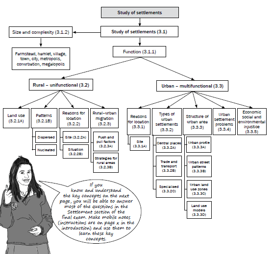 If you know and understand the key concepts on the next page, you will be able to answer most of the questions in the Settlement section of the final exam. Make mobile notes (instructions are on page x in the introduction) and use them to learn these key concepts.
Key concepts
| Concept | Definition |
| Agenda 21 (local) | A plan of action or process to ensure sustainable development by:
|
| Break-of-bulk town/city | Where one type of transport is replaced by another type, e.g. a harbour or port. |
| Central place town/city | Provides urban services to surrounding rural area. |
| Dispersed pattern/ isolated pattern | Buildings are arranged far apart from one another. |
| Dormitory town/city | A settlement which is mostly residential, as people work in a nearby city. |
| Dry-point settlement | A settlement in a wet area which could be flooded and so is situated away from the water source. |
| Function | Refers to the activities (primary, secondary or tertiary) that take place in settlements. |
| Gap town/city | A town or city situated at a point of access over or through a physical barrier, e.g. at a mountain pass. |
| Hierarchy | Ranking of places from villages to megalopolis OR ranking of functions or orders within an urban centre. |
| Informal settlement | An informal or unplanned area that is occupied by people who do not have access to formal housing and who erect dwellings on open land, usually on the outskirts of a town. Buildings are made of cardboard, zinc, plastic or wood, or any available materials. It is also sometimes called a squatter camp or shanty town. |
| Junction town/city | Where two major transport routes meet. This can be roads or railway lines. |
| Land use zones | Areas in an urban area that have a specific purpose or function. |
| Minimum service area | The minimum area needed to maintain a settlement, service or function. |
| Multifunctional | This is classified as urban because it has both secondary and tertiary activities. |
| Nucleated pattern/ clustered pattern | Buildings are arranged close to one another. |
| Pull factors (positive factors) | The qualities of an area that make people want to move there. |
| Push factors (negative factors) | Problems experienced in an area that make people move away. |
| Range | The maximum distance people are prepared to travel to a settlement or a function. |
| Rate of urbanisation | The speed at which urbanisation is taking place. |
| Rural depopulation | A decrease in the number of people living in rural areas as the population ages because young people are leaving. |
| Rural–urban migration | People move from the rural areas in search of better opportunities in cities. |
| Settlement | A group of people living on a day-to-day basis in an area that has buildings, communication networks and functions. |
| Settlement pattern | This refers to a settlement being arranged either in a nucleated or dispersed manner. |
| Site | The actual piece of land that a settlement is found on. |
| Situation | The settlement in relation to its surrounding environment. |
| Specialised town/city | A town or city with one main dominant function. |
| Sphere of influence | The maximum area served by a settlement or function. |
| Threshold population | The minimum number of people needed to maintain a settlement or function or to keep it profitable. |
| Trade and transport town/city | Town or city found near to or on transport routes. |
| Types of towns/cities | There are three main types of towns/cities:
|
| Types of settlements | These are classified as either rural or urban according to function. |
| Unifunctional | This is classified as rural because it has mainly primary activities. |
| Urban expansion | The area that an urban area uses (physical area) increases over time, e.g. new buildings and infrastructure. |
| Urban growth | The number of people living in an urban area increases by natural increase (births minus deaths) as well as rural–urban migration. |
| Urban profile | The view of an urban area from the side to indicate the different land use zones. |
| Urbanisation | An ever increasing percentage of the total population living in urban areas. |
| Village shapes | Rural villages are classified as linear, round/square or crossroads. |
| Wet-point settlement | A settlement in a dry area situated near to a water source. |
3.1 Study of settlements
In this chapter we learn that settlements are classified according to function, or size and complexity.
3.1.1 Function
- Rural settlements are mainly unifunctional (they have one main function) with only primary economic activities occurring, e.g. farming or forestry.
- Urban settlements are multifunctional (they have many functions), i.e. they have both secondary activities (factories/manufacturing) and tertiary activities (services).
3.1.2 Size and complexity
- Settlements are classified from the smallest to the largest.
- A farmstead, hamlet and village are rural settlements.
- A town, city, metropolis, conurbation and megalopolis are urban settlements.
Study Figure 3.1.2 below to understand the differences in size and complexity of rural and urban settlements.
| Rural | Farmstead A single farm and outbuildings Hamlet A loose grouping of a few farmsteads Village A denser grouping of many farmsteads |
| Urban | Town A densely populated urban area, e.g. Harrismith or Beaufort West City A large town where many people live and work, e.g. East London, Bloemfontein Metropolis A main city in a region which is surrounded by dependent towns, e.g. Cape Town, Durban, Port Elizabeth Conurbation A large urban area formed by the growth and coalescence of a number of cities and towns, e.g. Witwatersrand Megalopolis A gigantic urban complex formed when a number of conurbations join, e.g. Boston, New York and Washington (Bonywash) |
Figure 3.1.2: Size and complexity of settlements
It is important to be able to classify settlements according to their function, size and complexity, and pattern.
Activity 3.1
Complete the table to illustrate your understanding of the classification of settlements as either rural or urban.
| Rural | Urban | |
| Function (activity) | (1 × 2 = 2) | (1 × 2 = 2) |
| Size and complexity (smallest to largest settlements) | (3) | (5) |
[12]
Answers to activity 3.1
| Rural | Urban | |
| Function (activity) | Unifunctional (primary activities) (2) | Multifunctional (secondary and tertiary activities)(2) |
| Size and complexity (smallest to largest settlements) | Farmstead, hamlet and village(3) | Town, city, metropolis,conurbation, megalopolis (5) |
[12]
3.2 Rural settlements
Rural settlements are the smallest settlements which are unifunctional.
They are farmsteads, hamlets or villages, where primary activities (farming, fishing, forestry or mining) take place. Figure 3.2.A illustrates a rural settlement.
Land use in rural settlements
The largest land use in South Africa is agriculture. Approximately 12, 1% of the land is used for both commercial and subsistence cultivation of crops.
Although rural communities focus on primary economic activities (farming and forestry), there are a number of different ways in which the land in these settlements can be used.
Subsistence farming involves using the land to grow crops and breed animals that are a source of food for the family living on the farm. The aim is not to sell the goods, but to consume them.
Commercial farming is practised where the land is used to grow crops or breed animals that are then sold as food sources to other markets. The main aim of this rural land use is to generate income for the farmers.
Commercial farming can be either intensive or extensive.
Commercial farming can be divided into:
- Stock farming: Animals, for example, cows, chicken, sheep, pigs.
- Crop farming: Cultivation of land, for example, maize, wheat, fruit, vegetables.
- Mixed farming: A combination of stock and crop farming.
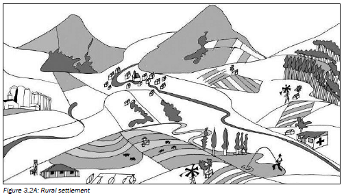
You need to know how to identify stock and crop farming on a map.
Rural settlement patterns
A rural settlement pattern refers to whether the farmsteads are grouped together or not. There are two rural settlement patterns:
- Nucleated pattern: Farmsteads are arranged close to one another. Figure 3.2.B (below left) shows a nucleated pattern. These buildings are rural, so they cannot be classified as being larger than a hamlet or village.
- Dispersed pattern: Farmsteads are arranged far apart from one another. Figure 3.2.C (below right) shows a dispersed pattern.
This can only be an isolated farmstead – this is one farm house, stables or sheds or kraals, and surrounding fields.
Try to imagine yourself living in these different settlement patterns to help you remember the advantages and disadvantages.
In an exam you may be asked to identify the pattern of settlement (nucleated or dispersed). Learn Figures 3.2B and 3.2C below to enable you to answer this question.
In the exam, you may be asked what the advantages or disadvantages are of living in a nucleated or dispersed settlement. Study table 3.1 (right) to help you answer this question.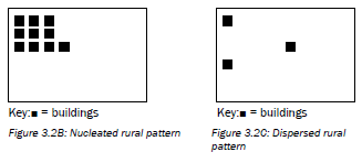
| Nucleated rural settlement | |
| Advantages | Disadvantages |
|
|
| Dispersed rural settlement | |
| Advantages | Disadvantages |
|
|
Table 3.1: Advantages and disadvantages of living in a dispersed or nucleated rural settlement
When you learn these advantages and disadvantages remember that:
- If it is an advantage for nucleated it will be a disadvantage for dispersed.
- If it is a disadvantage for dispersed it will be an advantage for nucleated.
3.2.1 Reasons for the location of rural settlements
Where a settlement occurs is referred to as its location. We will discuss the location of settlements under the headings site and situation.
- The site of a rural settlement refers to the exact piece of ground the settlement is found on.
- The situation of a settlement refers to the settlement in relation to its surrounding environment.
Figure 3.2.1A below illustrates the relationship between the site and the situation of a settlement.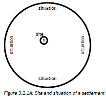
Site of a rural settlement
When choosing a site for rural settlements, the following factors are considered:
- Availability of water
- Arable (fertile) land
- Pastoral (grazing) land
- Building materials
- Fuel such as wood from a forest
Situation of a settlement
When choosing a situation for rural settlements the following factors are considered:
- Above the flood line away from a river
- On the north-facing slope for warmer temperatures
- In the thermal belt for warmer night time temperatures
- Next to a road for accessibility
These last two factors are not as relevant today as they were in the past.
In an exam you may be asked to identify factors that affected the choice of the site of a particular settlement in a diagram. In this type of question if a key is given, study it carefully to help you answer the question.
Activity 3.2
Study the two rural settlement diagrams in Figures 3.2.1B and 3.2.1C and complete the table.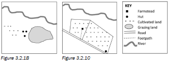
| Figure 3.2.2B | Figure 3.2.2C | |
| Function | (1 × 2 = 2) | (1 × 2 = 2) |
| Settlement pattern | (1 × 2 = 2) | (1 × 2 = 2) |
| Factors affecting the site | (1 × 2 = 2) | (1 × 2 = 2) |
| Factors affecting the situation | (1 × 2 = 2) | (1 × 2 = 2) |
[16]
Practise applying what you have learnt about the site and situation of rural settlements by completing Activity 3.2.
Answers to activity 3.2
| Figure 3.2.2B | Figure 3.2.2C | |
| Function | Rural/unifunctional (2) | Rural/unifunctional (2) |
| Settlement pattern | Nucleated (2) | Dispersed/isolated(2) |
| Factors affecting the site | Arable land Drinking water (any 1) (2) | Arable land Drinking water Grazing land (any 1) (2) |
| Factors affecting the situation | Away from water Dry point settlement (any 1) (2) | Away from water Dry point settlement Near a road for transport (any 1) (2) |
[16]
3.2.2 Rural-urban migration
As countries develop and urban areas expand, more and more people move from the rural areas to cities and towns. This movement of people from a rural area to an urban area is called rural-urban migration.
In this section we look at the factors that cause people to leave the rural areas (push factors) and move to the urban areas (pull factors). We will also look at what governments do to keep people in the rural areas.
Push and pull factors causing people to leave the rural areas
Table 3.2 below summarises the factors that make people want to leave the rural areas and move to cities.
Make sure you understand the difference between push and pull factors.
Push factors Remember, these make you want to leave rural areas. | Pull factors Remember, these make you want to move to urban areas. |
| Natural disasters, such as drought or floods, have a greater impact in rural areas. | Natural disasters have a smaller impact; government provides more help to urban areas during droughts and floods. |
| Lack of facilities in rural areas, e.g. fewer schools, colleges or universities, and fewer hospitals or clinics in rural areas | Better and more access to education and medical facilities in urban areas |
| Lack of services in rural areas, e.g. water, electricity, transport | Better access to services in urban areas, e.g. water, electricity, transport |
| Lack of employment in rural areas – few jobs are available and there is little variety in the types of jobs available | More jobs and more types of jobs available in urban areas |
| Lack of housing in rural areas | More housing and better housing available in urban areas |
| Lack of recreational facilities, entertainment and social interaction in rural areas | More recreational facilities, entertainment and social interaction in urban areas |
| Poverty in rural areas, which limits people's chances of improving their standard of living. | Better standard of living possible in urban areas |
Table 3.2: Push and pull factors
Strategies for getting people to stay in rural areas
Rural to urban migration causes many problems in rural and urban areas. Because of this, the government has various solutions or strategies (plans) to keep people in rural areas and to attract people back to rural areas.
Agenda 21 is a broad strategy to develop rural areas. Some of the basic ideas are included in the list below:
- Before you can implement a solution, it is important to speak to the local people and get their ideas on how to improve the area.
- Solutions should look to use the skills and talents of the local people.
- Basic needs (food, shelter, clothing and clean running water) must be satisfied before other development can happen.
- Improve services (like electricity and roads) and facilities (like hospitals and schools) to encourage people to stay in the area.
- When providing for these basic needs, such as building roads or clinics, use local labour and train people so they can use their new skill or trade to earn a living in the area.
- Improve food security by educating farmers in the use of better farming methods, tools and seeds.
- Attract secondary activities, like factories, to rural areas. Encourage these industries to use local raw materials and skills to ensure rural people are employed.
Rural depopulation does not only affect rural areas but also small towns. Many people are leaving small towns to move to the big cities. Below are some basic ideas to consider when improving small towns:
- Improve roads to and from the small town.
- Upgrade facilities in the small town.
- Town councils must find ways to advertise their town to attract tourists or people to come and live there, for example:
- Build old age homes and offer services specifically for older people. This would attract older people to retire to the small town.
- Develop a holiday resort, or attract people for weekend getaways to the small town.

3.3 Urban settlements
Urban settlements are towns or cities where secondary and tertiary activities take place. More and more people are living in urban areas so towns are growing larger and more complex all the time. Figure 3.3A below shows an urban settlement.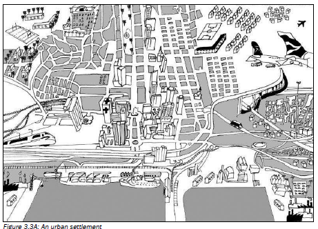
3.3.1 Reasons for the location of urban settlements
Where a settlement is found or occurs is referred to as its location.
Site of an urban settlement
When choosing a site for urban settlements, the following factors are considered:
- Availability of water: This is no longer as relevant, since water can be piped over long distances.
- Soil: People prefer to build on soil which allows water to drain through it. It is difficult to build on clay because water collects on top of this type of soil.
- Rock structure: Sites which are far from sinkholes, fault lines and volcanoes are better to build on.
- Relief: Sites with gentle gradients are preferred, as building costs
are cheaper. - Transport and trade: Development often occurs at a river crossing.
- Human factors: Sites with historical, cultural or social value attract people to live in the area.
In an exam you may be asked to identify factors that affected the choice of a particular settlement in a diagram. In this type of question, if a key is given look at it carefully to help you answer the question. Learn the information (left) to help you answer this question.
3.3.2 Types of urban settlements
Urban areas are classified according to their function (the main reason why they are there). There are three main types of urban areas:
- Central places
- Trade and transport towns or cities
- Specialised town or cities
Table 3.3 summarises the three types of urban areas.
| 1. Central places | ||||
| Small towns supplying urban goods and services to surrounding rural areas | ||||
| Low order good/service • Need often (bread, milk, doctor) • Smaller threshold population • Several shops/services | High order good/service • Don't need or need less often (e.g. TV, health spa) • Larger threshold population • Few shops/services | |||
| 2. Trade/transport towns or cities | ||||
| Develop where transport routes meet | ||||
| Break of bulk Transport changes, e.g. from sea to land  Example: Durban | Junction Intersection of two main transport routes 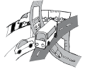 Example: De Aar (Touws River) | Gap Point of access at physical barrier (e.g. mountain pass) 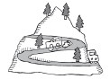 Example: De Doorns (Hex River Pass) | ||
| 3. Specialised towns or cities | ||||
| Develop because of one main function in the area | ||||
Mining Example: Welkom | Education Example: Grahamstown | Industrial Example: Secunda | Resort Example: Margate | Commuter/dormitory Example: Soweto |
Table 3.3: The three types of urban areas
| Use the word CRIME to help you remember the different types of specialised towns: C Commuter R Resort I Industrial M Mining E Education |
Make up your own mnemonics to remember the facts about these three types of urban areas (see page xi in the introduction to learn more about mnemonics).
Central places
Central places are small towns that supply urban services to the surrounding rural area. They have shops that sell basic goods or provide basic services to people who live and work on the farms in the area. Goods or services may be classified as low or high order. Study Table 3.4 below to learn the differences between low and high order goods or services.
| Low order goods/services | High order goods/services | |
| Definition | A function or good you need or buy often | A function or good you buy less often or do not need on a regular basis |
| Examples | Low order goods: bread, milk, petrol Low order services: doctors, mechanics | High order goods: television, designer shoes High order services: specialist doctors, health spas |
| Threshold population | Smaller number of people | Larger number of people |
| Number of these shops or services | Many – people want to buy low order goods and services on a regular basis | Few – people do not need high order goods and services very often |
Table 3.4: Low and high order goods or services
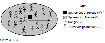
- Threshold population: The number of people a function must serve in order to be profitable, or the number of people needed to support a function or town. Threshold population refers to how many customers a shop or service must have in order to be profitable.
- Range: The distance a person will travel to obtain a particular good or service. Range refers to how far someone will travel to buy a particular product or access a particular service.
- Sphere of influence or service area: The area served by a business selling a particular good or service. This is the area where people live who buy goods from a particular shop or use a particular service.
Make sure you know these three definitions which relate to central places. They are easy marks!
Activity 3.3
- Expand the blank diagram in Figure 3.3.2A below and use the following terms to add a key to the diagram:
- Threshold population (1 × 2 = 2)
- Range (1 × 2 = 2)
- Sphere of influence (1 × 2 = 2)

- Write definitions to show your understanding of the terms in a), b) and c). (3 × 2 = 6)
[12]
Apply what you have learnt about central places by completing activity 3.3.
Answers to activity 3.3
|
Trade and transport towns or cities
These are towns or cities which develop at a point where transport routes meet. Easy access to trade and transport in the area is the reason why people settle there.
There are three types of trade and transport cities:
- Break-of-bulk towns or cities: They develop at a point where the type of transport changes. This is most often at a harbour where the transport changes from sea to land.
- Junction towns or cities: They develop at an intersection of two major transport routes, for example a railway junction.
- Gap towns or cities: They develop at a point of access through or over a physical barrier, for example at a mountain pass.
Specialised towns or cities
These are towns or cities which have developed because of one main or dominant function occurring in the area. If the function were to stop then the city would be at risk of becoming a ghost town (a deserted town).
Examples of specialised towns or cities are:
- Mining towns or cities, e.g. Welkom
- Education towns or cities, e.g. Grahamstown
- Industrial towns or cities, e.g. Secunda, Sasolburg
- Resort towns or cities, e.g. Margate
- Dormitory or commuter towns or cities, e.g. Soweto
In an exam, you may be asked to identify the type of trade and transport city in a diagram. If a key is given, look at it carefully to help you answer the question. Learn the information above to help you answer this question.
3.3.3 Structure of an urban area
The study of an urban area involves focusing on the following three aspects:
- Urban profile
- Urban street patterns
- Urban land use zones
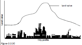
Urban profile
An urban profile is a view of the urban area from the side, like looking at the side view of a person’s face. We call the side view a profile. A profile is seen in cross section drawings.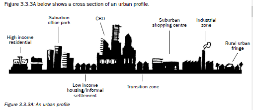 When we study an urban profile we take note of the height, the density of the buildings, and land value.
- Looking at the city from the centre towards the outskirts
The height of the buildings decreases the further away you go from the centre of the city. The density (how many buildings there are in an area) also decreases the further you go from the city centre. The reason for the decrease in density and height is because land value decreases as you move away from the centre of the city. - Looking at a city from the outskirts towards the centre
The height of the buildings increases the closer you get to the city centre. The density of the buildings also increases the closer you get to the city centre. - Thinking about land value
Land value in the centre of the city is very high because it is in high demand (lots of people value it and want to live or work there). The land value decreases the further you go from the city centre. The density and height in the centre of the city is highest because of the high land value. People must make maximum use of the land. This is why there are many high-rise buildings in the city centre.
Due to the high land value in the city centre, certain functions will move to the outskirts of the city, such as factories, businesses and residential (houses). Factories and business are often located in specific areas known as industrial or office parks. Houses are located in residential suburbs.
Figure 3.3.3B below shows the urban profile and how the land value decreases from the central business district (CBD) towards the outskirts of the urban area.In an exam you may be asked to describe how the building density or buildings might change as you move away from the CBD. You may also be asked to explain why the height or density of buildings changes. Learn the information above to help you answer this question.
Activity 3.4
- On the urban profile shown in Figure 3.3.3B on page 56 draw a line graph to show how land value changes as you move towards the CBD. (1 × 2 = 2)
- How does building density change as you move towards the centre of the city? (1 × 2 = 2)
- Explain your answer in question 2. (2 × 2 = 4)
- Why would an office park move away from the Central Business District? (2 × 2 = 4)
[12]
Apply your understanding of urban profiles by completing Activity 3.4.
Answers to activity 3.4
|
Urban street patterns
The structure of an urban area can be studied from above by looking at the patterns formed by the streets of the urban area. The layout or arrangement of the roads is called the street pattern. In this section we focus on four street patterns:
- Gridiron
- Radial
- Planned irregular
- Unplanned irregular
Study Figures 3.3.3A to D to G (below and on page 58) to understand the four street patterns.
Gridiron street pattern
Advantages of the gridiron street pattern
Disadvantages of the gridiron street pattern
| 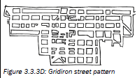 |
In Paper 1 or Paper 2 you may be asked to identify the street pattern and state the advantages and disadvantages of the street pattern. You may also be asked to give the age of a settlement based on the street pattern in the settlement.
Radial street pattern
Advantages of the radial street pattern
Disadvantages of the radial street pattern
| 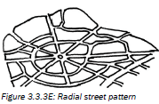 |
Planned irregular street pattern
Advantages of the planned irregular street pattern
Disadvantages of the planned irregular street pattern
| 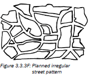 |
Unplanned irregular street pattern
Advantages of the unplanned street pattern
Disadvantages of the unplanned street pattern
| 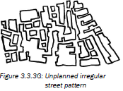 |
Urban land use zones
The structure of an urban area can be studied by looking at the different land use zones in a city. A land use zone is an area which has features that define its function. For example, a residential area is made up of houses or flats, recreational areas, schools and shops. These features tell us that people live in the area. Another example is an industrial area, which is made up of many large buildings (factories), major transport routes and few open or green areas.
Urban street patterns will be tested in activity 3.5 in the mapwork interpretation of settlement based on the Nelspruit map.
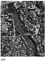
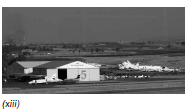
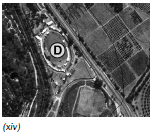
The photographs and some orthophotos in Figures 3.3.3H (i)–(xiv) below show different land use zones and their features. An orthophoto is an aerial photograph that has been geometrically corrected so that the scale is uniform and there is no visual distortion. Remember, aerial means ‘seen from above’.
| Description | Photograph | Orthophoto |
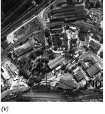
Central Business District (CBD)
| 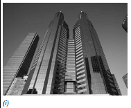 | 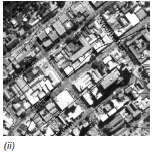 |
Transition zone
|  | |
Light industry
| 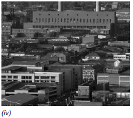 |  |
Heavy industry
| 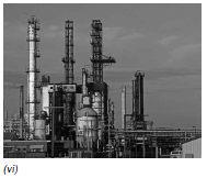 | |
Middle- to high-income residential/upper class residential
| 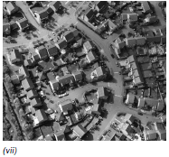 | 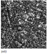 |
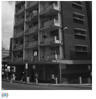
Low-income residential/working class residential
| 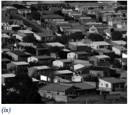 | |
Informal settlement
| 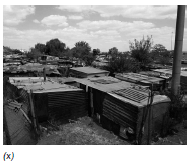 | |
Green belt/recreation
| 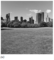 |  |
Rural urban fringe
|  |  |
See if you can find examples of these land use zones in the area where you live.
Land use models
Land use models are simplified diagrams which are used to represent the pattern of land use functions within a city or a town. It should be remembered that these are a simplification of reality and it is unlikely that any model will fit every town or a city well.
The urban models listed below are a few examples of the currently used urban models in the world.
They are:
- Multiple nuclei model
- The modern American-Western city model
- Third world city model
- South African city model.
As cities developed and changed over time, people designed land use models to represent the patterns of land use at that time. Today most cities fit the multiple nuclei model.
In developing countries cities have a different pattern, with sections that are well developed and defined (for example, areas where the colonial powers lived), and sections that are unplanned and irregular (for example, areas where the indigenous people lived). The irregular sections have grown due to rural-urban migration.
South African cities have a completely different pattern due to apartheid laws like the Group Areas Act. Our cities have a multiple nuclei pattern with some additions – see Figure 3.3.3K.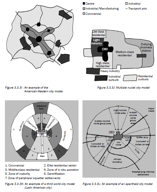
Land use zones and mapwork interpretation
Working class residential zone
Upper class residential areas
Heavy industry
|
In Paper 1 and Paper 2 you may be asked to identify the land use zones seen in diagrams, cartoons, photographs and on a topographic map or on an orthophoto. You may also be asked to describe the characteristics of the land use zone. Learn the above information to help you answer the question.
Activity 3.5
This activity is a mapwork interpretation of a settlement. Refer to the topographic map 2530BD Nelspruit and the orthophoto map extract at the back of this study guide and answer the following questions.
- Nelspruit/Mbombela is the capital of which South African province? (1 × 2 = 2)
-
- What factors influenced the site of Nelspruit/ Mbombela? (4 × 2 = 8)
- Discuss the situation of Nelspruit/Mbombela. (3 × 2 = 6)
-
- Identify the settlement pattern in block C2. Give a reason to support your answer. (2 × 2 = 4)
- What is the shape of the settlement in block B3? Why do you think it has taken this shape? (2 × 2 = 4)
- Classify the type of farming in block C3 as fully as possible, explaining your answer. (3 × 2 = 6)
-
- What is different about the farm Friedenheim in block C5? (1 × 2 = 2)
- How could this farm help to prevent rural–urban migration? (1 × 2 = 2)
- What type of city would Nelspruit/Mbombela be classified as? Explain your answer. (2 × 2 = 4)
-
- Give the block reference of the land use zone known as the CBD. (1 × 2 = 2)
- Draw a simple cross section sketch to illustrate the urban profile of the land use zone in question a). (2 × 2 = 4)
- What type of street pattern is found in this zone?
Give two advantages and two disadvantages for this street pattern. (5 × 2 = 10)
- West Acres is an example of an upper income residential area. Give two reasons from the map to support this statement. (2 × 2 = 4)
Study the orthophoto at the back of the study guide. - What land use is found at A, B, C and D? (4 × 2 = 8)
- The residents of West Acres do not like travelling to the centre of Nelspruit/Mbombela to do their shopping as it has become so congested. Where would you suggest that they build a new shopping mall? Explain why you have chosen this site to build on. (3 × 2 = 6)
[70]
Answers to activity 3.5
|
Study Tables 3.5 to 3.7 to learn about the causes, effects and solutions to these three urban problems.
3.3.4 Urban settlement problems
As an urban area grows and more people move into the area, certain problems are created and get worse as the city gets bigger. These problems are often worse in the CBD.
In this section we focus on the following three urban problems:
- Congestion
- Urban decay
- Centralisation
| Problem: Congestion (too many cars on the roads) | ||
| Causes | Effect | Solution |
|
|
|
Table 3.5: Causes, effects and solutions to the urban problem of congestion
| Problem: Urban decay (where parts of the city are not looked after or are over-used) | ||
| Causes | Effect | Solution |
|
|
|
Table 3.6: Causes, effects and solutions to the urban problem of urban decay
| Problem: Centralisation (too many people and activities moving into the city, close to centre) | ||
| Causes | Effect | Solution |
|
|
|
Table 3.7: Causes, effects and solutions to the urban problem of centralisation
In an exam you may be asked to state the causes or effect or solution to an urban problem. You may also be asked to describe the causes or effect or solution to an urban problem in a paragraph.
3.3.5 Economic, social and environmental injustice
In geography you are often asked to describe, explain, or discuss the effect, impact, or injustice of particular phenomena. To do this, we first need to understand the meanings of these words.
- Injustice: inequity, unfairness, unjustness, wrong, grievance; means an act that inflicts undeserved hurt. Injustice applies to any act that involves unfairness to another or violation of one’s rights
- Opposite of injustice: equity, fairness, justice.
- Economic injustice: when different people have different levels of income in a society.
- Social Injustice: the distribution of advantages and disadvantages within a society.
- Environmental injustice: the unfair distribution of environmental benefits and burdens. Environmental justice is the fair treatment and meaningful involvement of all people regardless of race, colour, national origin, or income with respect to the development, implementation, and enforcement of environmental laws, regulations, and policies.
- Impact: the effect or impression of one thing on another.
- Effect: something brought about by a cause or agent; a result or outcome.
In Geography when a question refers to economic, social and environmental factors, impacts or injustices the term relates to the following:
- Economic: this term deals with the making of or losing money by business, countries, and individuals. It includes economic activities (primary, secondary, and tertiary activities). It is concerned with the human-made environment; the infrastructure and buildings.
- Social: this term relates or deals with people, demographic factors (birth rates, death rates, income, literacy levels and employment), and basic needs.
- Environmental: of, relating to, or associated with the environment.
In a test or exam the question would be as shown below. Possible answers are given.
Discuss the economic, social, and environmental injustices of the following:
Or
Discuss the economic, social, and environmental impacts or effects of the following:
- Flooding (Mid-latitude cyclones, tropical cyclones)
- Drought (HP cells)
- Global warming
- Mining
- Zone of decay/Overpopulation or overcrowding
- Rural depopulation
- Globalisation/Increased trade
Activity 3.6
Refer to Figure 3.3.5A below, which shows a settlement typical of the South African urban landscape. It shows urban functions or services of a low and a high order.
-
- What is a settlement? (1 × 2 = 2)
- Is the settlement shown in Figure 3.3.5A a rural or an urban settlement? (1 × 2 = 2)
- Give one reason for your answer to question b) above. (1 × 2 = 2)
-
- Distinguish between a low-order function and a highorder function. (2 × 2 = 4)
- From Figure 3.3.5A, identify one low-order function and one high-order function. (1 × 2 = 2)
- Explain the meaning of the term sphere of influence of a function or service. (1 × 2 = 2)
- Will the hospital or the café have a larger sphere of influence? (1 × 2 = 2)
- Explain your answer to question d) above. (2 × 2 = 4)
-
- The bakery is an example of a light industry. What is a light industry? (1 × 2 = 2)
- Unlike a heavy industry, the bakery can be located close to the hospital. Explain why this bakery does not have to be located outside the city. (2 × 2 = 4)
- Why is it important for the bakery to have a central location? (2 × 2 = 4)
-
- With reference to Figure 3.3.5A, explain why many people from the surrounding rural areas are attracted to this settlement. (2 × 2 = 4)
- Explain why it is important for the illustrated settlement to slow down the movement of people from rural areas to this settlement. (2 × 2 = 4)
[38]
Apply your knowledge from the whole settlement section to complete activities 3.6 and 3.7.
Answers to activity 3.6
|
Activity 3.7
Refer to Figure 3.7 and read the following extract (Cape Peninsula) before you answer the questions that follow.
| The Cape Peninsula stretches from the Cape of Good Hope and Cape Point northwards to Table Mountain and the city of Cape Town. It comprises, for the most part, strikingly beautiful mountains, including the well-known Table Mountain which overlooks the bay and city. Its western and eastern shorelines are graced by attractive residential and resort centres that are a magnet for holiday-makers. (Adapted from Traveller’s Guide to South Africa) |
Question 1
Refer to the wine farms located in the area of Constantia. Wine farm estates are examples of isolated farmsteads.
1.1 Define the term isolated farmstead. (1 × 2 = 2)
1.2 State two economic advantages of this settlement pattern. (2 × 2 = 4)
1.3 Describe two social disadvantages of this settlement pattern. (2 × 2 = 4)
1.4 Wine farms in South Africa form part of all three economic activities: primary, secondary and tertiary activities. Explain this statement in a short a paragraph (no more than 12 lines). (6 × 2 = 12)
[22]
Question 2
Study the city of Cape Town in the centre of Figure 3.7 to answer the following questions.
2.1 Define the term site. (1 × 2 = 2)
2.2 What two factors were responsible for the site chosen for the development of Cape Town? (2 × 2 = 4)
2.3 Why is Cape Town classified as a break-of-bulk point? (1 × 2 = 2)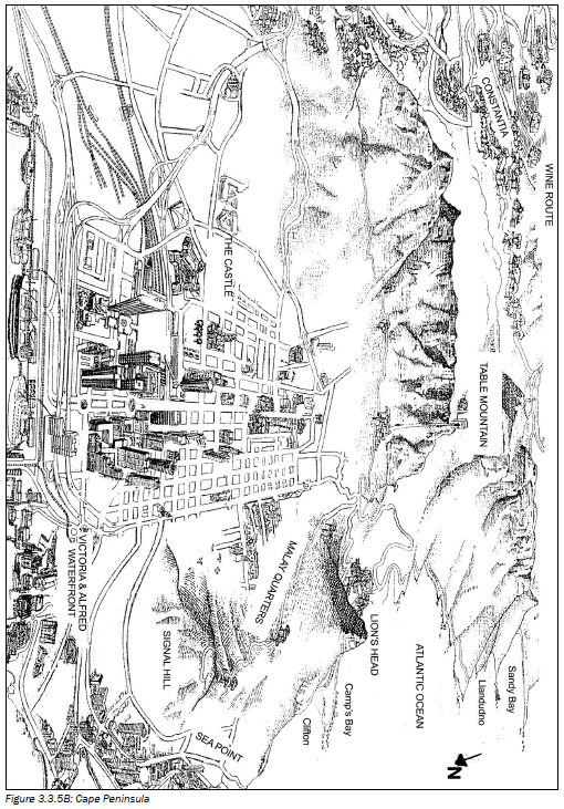 2.4
2.4
- What do the letters CBD stand for? (1 × 2 = 2)
- Identify the street pattern of the CBD of Cape Town. (1 × 2 = 2)
- Provide one advantage and one disadvantage of this street pattern. (2 × 2 = 4)
- With reference to Figure 3.7, identify one characteristic of the CBD’s profile. (1 × 2 = 2)
- Explain why the CBD has the characteristic you identified in question d). (2 × 2 = 4)
2.5 What evidence is there that the CBD of Cape Town is the most accessible land use zone? (1 × 2 = 2)
[24]
Question 3
Refer to the residential areas of Sea Point and the Malay Quarters.
3.1
- Classify the two areas as low- or high-income areas respectively. (2 × 2 = 4)
- Explain your classification of Sea Point in question a) by referring to evidence from Figure 3.7. (2 × 2 = 4)
3.2 The open space around the Malay Quarter may attract migrants from the rural areas.
- What is likely to develop here as a result of this migration? (1 × 2 = 2)
- Explain the occurrence of this development. (2 × 2 = 4)
- State two reasons for these migrants leaving the rural areas. (2 × 2 = 4)
- What problems are associated with this development? (2 × 2 = 4)
- You are part of a task team set up by the government to provide suggestions on how to slow the movement of people from the rural areas, as well as attract people back to small towns. In a short paragraph (no more than 12 lines), discuss some of your suggestions. (6 × 2 = 12)
[34]
Question 4
4.1 Provide the correct term for the following phrases:
- A settlement where only primary activities occur (1 × 2 = 2)
- An urban settlement which consists of a main city with surrounding dependent towns (1 × 2 = 2)
- The increase in the number of people living in an urban area (1 × 2 = 2)
- A resource from the earth which cannot be replenished. (1 × 2 = 2)
- The economic sector which involves the accessing and distribution of information. (1 × 2 = 2)
4.2 Match the columns. Simply write the number of the term in Column A next to the letter of the correct phrase from Column B.
| Column A | Column B |
|
|
Answers to activity 3.7 Question 2
2.5 All transport routes converge in the CBD. 33 (2) Question 3
3.2
Question 4
4.2
|
[20]