GEOGRAPHY PAPER 1 GRADE 12 MEMORANDUM - NSC PAST PAPERS AND MEMOS FEBRUARY/MARCH 2018
Share via Whatsapp Join our WhatsApp Group Join our Telegram GroupGEOGRAPHY
PAPER 1
GRADE 12
NSC PAST PAPERS AND MEMOS
FEBRUARY/MARCH 2018
MEMORANDUM
SECTION A: CLIMATE, WEATHER AND GEOMORPHOLOGY
QUESTION 1
1.1
1.1.1 Atlantic Ocean (1)
1.1.2 Ridge/Wedge (1)
1.1.3 1021 hPa/mb/between 1020 hPa and 1022 hPa (1)
1.1.4 South Indian/Mauritius High Pressure/Anticyclone (1)
1.1.5 Stable (1)
1.1.6 Clockwise (1)
1.1.7 25 °C (1)
1.1.8 Summer (1) (8 x 1) (8)
1.2
1.2.1 A (1)
1.2.2 F (1)
1.2.3 C/D (1)
1.2.4 D (1)
1.2.5 E/C (1)
1.2.6 B (1)
1.2.7 G (1) (7 x 1) (7)
1.3
1.3.1
- West (1)
- Westerly (1)
- Westwards (1)
- East to West/Southwest (1)
[ANY ONE] (1 x 1) (1)
1.3.2
- 10°S/south of the equator (1)
- Path of the Tropical Storm is east to southwest (1)
- Dangerous quadrant is in the bottom left/southwestern quadrant of the system (1)
- Clockwise circulation of ascending air (1)
[ANY TWO] (2 x 1) (2)
1.3.3
- The forward movement of the system and wind direction in the system is moving in the same direction and combines (2)
- The intense winds of the cyclone meets with the force of the entire cyclone moving forward in this quadrant/semi-circle (2)
[ANY ONE] (1 x 2) (2)
1.3.4
- Deflected by the Westerlies (2)
- Anticyclonic circulation in Southern Hemisphere will deflect the cyclone (2)
- Weakening of tropical easterlies (2)
- Changes/differences in sea temperatures (2)
[ANY ONE] (1 x 2) (2)
1.3.5 EXPECTED WEATHER AND ITS IMPACTS ON COASTAL AREAS Torrential (heavy) rainfall:
- flooding of coastal areas (2)
- infrastructural damage (2)
- destruction of crops/livestock (2)
- injury/loss of life (2)
- devastation of coastal communities/economies (2)
- fertile top soil washed away (2)
- create difficulties for ships in docking in harbours (2)
Gale/hurricane force winds/storm surges:
- increases damage to roofs (2)
- destroy vegetated areas along coastline regions (2)
- increase the likelihood of storm surges (2)
- creates a likelihood of power failures and other service disruptions on coastal regions (2)
High level of water will make swimming impossible (2)
Storm conditions:
- will have an adverse effect on ecosystems (2)
- will have negative effect on tourism (2)
Positive:
- Torrential rainfall is a source of water for coastal areas (2)
- Wind clears air pollution/smog
[ANY FOUR IMPACTS EXPLAINED] (4 x 2) (8)
1.4
1.4.1 Night (1) (1 x 1) (1)
1.4.2
- Terrestrial radiation which results in the cooling of the surface (2)
- Cold surface of valley slopes is required to cool down the air which develops a cold, downslope wind at night (2)
- The cool air on the cooled surface gets heavy/dense and rolls down the slope naturally under gravity (2)
[ANY ONE] (1 x 2) (2)
1.4.3
- Cool air descends onto the valley floor and forces the warm air that was in the valley to rise (2)
- Risen warm air rests on top of the cold air (2)
- This results in an increase in temperature with height (2)
[ANY TWO] (2 x 2) (4)
1.4.4
- The atmosphere in the lower section of the valley cools down below dew point temperature (2)
- Condensation occurs in the lower section of the valley (2)
- Small, visible droplets form radiation fog in the lower part of the valley (2)
[ANY TWO] (2 x 2) (4)
1.4.5
- The settlement will be above the radiation fog (2)
- There won't be dampness (2)
- Un-obscured view of the valley (2)
- Situated in the warm thermal belt (2)
- Receives maximum insolation (2)
[ANY TWO] (2 x 2) (4)
1.5
1.5.1 A wide open area found next to the banks of a river/Large area of flat land found next to the banks of a river (1)
[CONCEPT] (1 x 1) (1)
1.5.2
- Formation of terraces alongside the river (1)
- Formation of valleys within valleys (1)
- A new floodplain has formed (1)
[ANY ONE] (1 x 1) (1)
1.5.3 Lower Course (1)
(Accept stage of old age/plain stage) (1 x 1) (1)
1.5.4
-
- Composed of fertile silt deposits which promotes cultivation of crops (2)
- Next to the river channel with easy access to water (2)
- Floodplains are generally flat surfaces which promotes easy cultivation/ use of machinery (2)
[ANY TWO] (2 x 2) (4)
-
- With rejuvenation, the river cuts down within the existing floodplain, forming a new floodplain (2)
- Each time the floodplain becomes narrower (2)
- Leaving less space for cultivation of crops (2)
- The older terraces now are too high above water to be used (2)
- Old terraces are less fertile as flooding no longer occurs over them (2)
- No/less deposition of fertile sediment (2)
- Difficult to use machinery (2)
- Results in a decrease in yield (2)
- Decreased accessibility to the farm (2)
- Leads to a decline in income (2)
[ANY FOUR] (4 x 2) (8)
1.6
1.6.1 It is the lowest level to which a river can erode (1)
[CONCEPT] (1 x 1) (1)
1.6.2 The land cannot erode down below sea level (2) (1 x 2) (2)
1.6.3
- The profile has a smooth and concave shape (2)
- No temporary base levels of erosion evident (2)
- No obstructions along the river course (2)
[ANY ONE] (1 x 2) (2)
1.6.4
- Due to a change in sea level, the gradient of the river becomes steeper (2)
- The river profile is no longer smooth (2)
- A knickpoint forms where the old sea level and now exposed sea-floor meet (2)
- Renewed energy starts to erode the new knickpoint upstream (2)
- River profile becomes multi-concave/irregular (2)
- A temporary base level of erosion will develop along the river course (2)
- River becomes undergraded (2)
[ANY TWO] (2 x 2) (4)
1.6.5 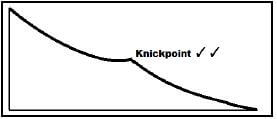 (1 x 2) (2)
1.6.6
- Erosion dominates in the upper course, removing all the obstacles (like waterfalls and rapids) in the upper course (2)
- Eroded material is deposited in the lower course (2)
- The balance that exists between erosion and deposition creates a concave profile (2) (2 x 2) (4) [75]
QUESTION 2
2.1
2.1.1 Air pressure decreases towards the centre/Lowest value in centre (1)
2.1.2 Along the west coast of South Africa (1)
2.1.3 Southwards/South-southeastwards (1)
2.1.4 Fog (1)
2.1.5 20°C (1)
2.1.6 Clockwise (1)
2.1.7 Berg winds (1) (7 x 1) (7)
2.2
2.2.1 B/sheet flow (1)
2.2.2 C/leveé (1)
2.2.3 C/base flow (1)
2.2.4 B/permanent (1)
2.2.5 A/trellis (1)
2.2.6 A/drainage pattern (1)
2.2.7 C/waterfall (1)
2.2.8 C/braided (1) (8 x 1) (8)
2.3
2.3.1 Cold front (1) (1 x 1) (1)
2.3.2
- Cumulonimbus clouds (1) (1 x 1) (1)
- Rapid uplift of warm air to great heights and large scale condensation (2) (1 x 2) (2)
2.3.3 Too far south of country (2) (1 x 2) (2)
2.3.4
Mid-latitude cyclone | Tropical cyclone | ||
Place of origin | 30° - 60°N/S (Polar front) Mid-latitudes [ANY ONE] | 5°- 30°N/S | (2) |
Wind belt | Westerly wind | Easterly wind Tropical easterly Trade wind [ANY ONE] | (2) |
[Must show the difference to get TWO marks] (2 x 2) (4)
2.3.5
- The coldest air is ahead of the warm front (2)
- This will cause the cool air behind the cold front to be uplifted (2)
- The cold front is displaced of the surface (2)
- Cool air behind rises over cold air in front (2)
[ANY TWO] (2 x 2) (4)
2.4
2.4.1
- An increase in temperature with an increase in height/altitude (1)
- Negative lapse rate (1)
[CONCEPT]
[ANY ONE] (1 x 1) (1)
2.4.2 Winter (1) (1 x 1) (1)
2.4.3 
- 1 mark for drawing of the escarpment
- 1 mark for position of inversion layer above the escarpment (2 x 1) (2)
2.4.4 In Summer
- Upper atmosphere warmer (2)
- Warmer air is lighter and less dense/surface low pressure (2)
- Warm air rising from the heated earth surface can force the inversion layer further upwards (2)
- Kalahari High is weak/poorly developed/weak subsidence of cold air (2)
In Winter
- The Kalahari High is dominant over the interior of South Africa (2)
- Upper atmosphere is colder thus strong subsidence (2)
- Colder air heavier and denser and forces the inversion layer down to below the escarpment (2)
[ANY TWO] (2 x 2) (4)
2.4.5 CLIMATE
- No moist air will be able to reach the interior (2)
- Limited condensation result in no cloud formation/clear skies (2)
- There will be a lack of rainfall/dry conditions (2)
- Lack of clouds increase terrestrial radiation and frost may occur (2)
- Atmosphere is stable (2)
- Apparent drought conditions will prevail (2)
ECONOMIC ACTIVITIES
- Limits crop cultivation due to the lack of rainfall (2)
- Only frost resistant crops can be grown (2)
- Seasonal labourers will have reduced income as there will not be sufficient work (2)
- Rivers dry up and will influence recreational activities reducing tourism (2)
- Less water will impact on industrial activity (2)
- Limited power supply as generation of hydro-electricity is less and cannot be fed into the national grid.
[ANY FOUR. MUST REFER TO CLIMATE AND ECONOMIC] (4 x 2) (8)
2.5
2.5.1 Drainage density is the total length of streams in a drainage basin divided by the total area of the drainage basin/The relationship between the length of streams in a drainage basin and the size of the drainage basin (1)
[CONCEPT] (1 x 1) (1)
2.5.2
- A has more tributaries (1)
- The total length of the streams at A is longer than that for B (1)
- There are many first order streams in A (1)
[ANY ONE] (1 x 1) (1)
2.5.3 2nd order (2) (1 x 2) (2)
2.5.4 There are more fingertip streams which join, increasing the drainage density further downstream (2) (1 x 2) (2)
2.5.5
- A large amount of vegetation will decrease the drainage density as the water is trapped by the vegetation and cannot flow as surface run-off (2)
- There will be fewer streams as the vegetation retards the flow of water (2)
- As vegetation traps water it promotes infiltration and less surface run-off will be experienced (2)
OR - A small amount of vegetation will increase the drainage density as the water is not trapped in the vegetation and will flow as surface run-off (2)
- There will be more streams as the vegetation does not retard the flow of water (2)
- As vegetation does not trap water, infiltration is reduced and it increases direct run-off (2)
[ANY TWO] (2 x 2) (4)
2.5.6
- A decrease in the infiltration of water in urban areas due to the artificial surfaces (2)
- An increase in surface run-off because of artificial surfaces (2)
- The surface water reaching the new urban area is removed by the storm water drainage system to areas surrounding the urban area (2)
- Therefore more water is available to create streams in this area which increases the drainage density (2)
- Natural vegetation has been cleared in urban areas creating more surface run-off (2)
[ANY TWO] (2 x 2) (4)
2.6
2.6.1 The main river and its tributaries (1) [CONCEPT] (1 x 1) (1)
2.6.2 Separates two tributaries/individual streams in the same drainage basin (1) (1 x 1) (1)
2.6.3
- Tributaries join the main river to resemble branches of a tree (2)
- Tributaries join at acute/small angles (2)
[ANY ONE] (1 x 2) (2)
2.6.4
- Rocks are uniformly resistant to erosion (2)
Associated with either massive igneous rocks or horizontal sedimentary rocks (2) (2 x 2) (4)
2.6.5 LOWER COURSE
- River flows over gentle gradient/flat landscape (2)
- The river attains a condition of dynamic equilibrium (2)
- The river starts weaving from side to side over the floodplain (2)
- Vertical erosion is limited and lateral erosion sets in (2)
- The stream velocity is decreased and the river loses its energy (2)
- The carrying capacity of the river decreases and material is deposited (2)
- Deposited material forms irregularities in the stream channel (2)
- These irregularities/deposited material deflects the stream from side to side (2)
- Once meandering starts it continues as stream follows path of less resistance (2)
[ANY FOUR] (4 x 2) (8) [75]
SECTION B: RURAL AND URBAN SETTLEMENTS AND SOUTH AFRICAN ECONOMIC GEOGRAPHY
QUESTION 3
3.1
3.1.1 Central Business District (CBD) (1)
3.1.2
- Transition zone (1)
- Zone of decay (1)
[ANY ONE]
3.1.3 Residential (1)
3.1.4 Light industry (1)
3.1.5 D (1)
3.1.6
- Rural-Urban Fringe (1)
Greenbelt (1)
[ANY ONE]
3.1.7 A/Central Business District (CBD) (1) (7 x 1) (7)
3.2
3.2.1 primary (1)
3.2.2 tertiary (1)
3.2.3 secondary (1)
3.2.4 quaternary (1)
3.2.5 Trade tariffs (1)
3.2.6 Large scale (1)
3.2.7 maize (1)
3.2.8 gold (1) (8 x 1) (8)
3.3
3.3.1 Site refers to the precise position selected for a settlement (1) Situation refers to how the site is selected in relation to the surrounding landscape (1) [CONCEPT] (2 x 1) (2)
3.3.2
- Where water is scarce, farmsteads are located close to the water source/wet point settlement (2)
- Where water constitutes a threat , the farmstead is located away from the water source e.g. flood threat/dry point settlement (2) (2 x 2) (4)
3.3.3 Topography/Relief/Type of slope (2)
- The gradient of the slopes will determine the type of farming being practiced on the site (2)
- Flat areas/floodplains are easy to cultivate/use machinery (2)
- There is less soil erosion on flat land (2)
Soils (2)
- The type of soil will determine the type of crops to be grown on the site of the farm (2)
- Fertile soil needed to ensure high production (2)
Micro-climate/Aspect (2)
- Slopes in the shadow zone are avoided due to lack of sunshine (2)
- North facing slopes are preferred in the southern hemisphere because they receive more sunshine which is good for crop cultivation (2)
Fuel (2)
- Proximity to trees to burn as fuel (2)
Pasturage (2)
- Close to natural grazing for animals (2)
[ANY ONE – DO NOT ACCEPT WATER] (2 x 2) (4)
3.3.4
- Access to markets to sell products (2)
- Access to shops to purchase resources (2)
- Access to banks and services (2)
- To save travel time and cost of fuel (2)
- Perishable goods produced on farms need to be closer to the market (2)
[ANY TWO] (2 x 2) (4)
3.4
3.4.1 The trend shows a decrease/decline in the number of rural people (1) (1 x 1) (1)
3.4.2 35,20 % (1) (1 x 1) (1)
3.4.3 34% - 35% (2) (1 x 2) (2)
3.4.4
- Rural depopulation (2)
- Family units are broken (2)
- Rural areas will not be sustainable for growth and development (2)
- A lack of investment in rural development projects (2)
- Quality of life will decrease/Standard of living declines (2)
- Basic services such as shops and schools close (2)
- Production decreases as there are fewer people (2)
- Ghost towns emerge/abandoned houses (2)
- Young people are likely to move to urban areas (2)
- Ageing population (2)
- Economy declines (2)
- Cycle of poverty continues (2)
- Less safe to live in (2)
[ANY TWO] (2 x 2) (4)
3.4.5
- Encourage investment in rural development farming projects (2)
- Establishment of agricultural schools and colleges (2)
- Improve skills and provide training for farmers/empower farmers (2)
- More research to improve food production (2)
- Access to water wise irrigation schemes (2)
- Water transfer schemes in order to ensure farming even in arid areas (2)
- Improved farming equipment (2)
- Give people land to practice farming (2)
- Provide grants/low interest loans to farmers (2)
- Access to insurance against crop losses (2)
- Access to hybrid/genetically modified seeds (2)
- Plant drought resistant crops (2)
- Moving away from monoculture to planting a variety of crops (2)
- Storing surpluses for times of shortages (2)
- Protect farmers to reduce farm killings (2)
- Implement all rural development policies (2)
[ANY FOUR] (4 x 2) (8)
3.5
3.5.1
- Primary: citrus (1) apples and pears (1) grapes (1) tobacco (1)
- Secondary: refined petroleum (1) wine (1) iron and steel (1) engine parts (1) fruit juice (1) dried fruit and nuts (1)
[ANY ONE OF PRIMARY AND SECONDARY] (2 x 1) (2)
3.5.2 Grapes (2) (1 x 2) (2)
3.5.3 R20,6 Billion (2) (1 x 2) (2)
3.5.4
- Fruit is the main raw material used in the food processing industry (2)
- Climate suitable for grape growing (for the making of wine) (2)
- Variety of fruit is suitable to be grown in this area (2)
- Large labour force available as fruit farming requires manual labour (2)
- There is a lack of minerals thus the Western Cape relies on fruit as a raw material (2)
[ANY TWO] (2 x 2) (4)
3.5.5
- Harbour facilities and harbour infrastructure to export to global markets (2)
- A highly efficient container shipping facility is accessible to the harbour (2)
- Refrigerated containers for transporting fruit overseas (2)
- Cape Town International Airport which provides links to major economies in the west (2)
- Top quality products produced for export (2)
- Increase demand for these products in Northern Hemisphere countries during the South African growing season (2)
- Most industries are established and mechanised (2)
- Road and rail links improve transportation links to the rest of South Africa (2)
[ANY TWO] (2 x 2) (4)
3.6
3.6.1 Farming on a small piece of land (commercial or subsistence) (1) [CONCEPT] (1 x 1) (1)
3.6.2
- Small patch of land (1)
- Manual labour (1)
- Traditional farming methods (1)
- No mechanisation evident (2)
- Variety of crops/mixed farming (1)
- Lack of infrastructure (2)
[ANY ONE] (1 x 1) (1)
3.6.3 Small piece of land farmed intensively (2) (1 x 2) (2)
3.6.4
- The land being farmed is very small (2)
- There are many farmers working on a small piece of land (2)
- Profit/low yields must be shared by all (2)
- Products only sold to local market (2)
- Some produce will be used to sustain themselves and their families (2)
- Use of traditional farming methods therefore farmers produce less (2)
- The products are usually of low quality due to lack of fertilisers and the impact of pests (2)
- The farmers have no access to formal markets to sell their products (2)
[ANY TWO] (2 x 2) (4)
3.6.5 PROBLEMS EXPERIENCED BY SMALL SCALE FARMERS
- Limited to manual labour (2)
- Limited to use of simple farm equipment (2)
- Limited knowledge of scientific farming methods (2)
- Water crops by hand/watering can (2)
- Overuse of land decreases soil fertility (2)
- Exposure to weather elements (2)
- Physical health of the workers suffer (2)
- Possible theft of produce (2)
- Birds insects are attracted to this plot (2)
- Yield decreases over time (2)
- Limited/No access to funds to buy seeds/fertiliser and supplies (2)
- No insurance against crop losses (2)
- Natural disasters like flooding and drought ruin farmer (2)
- The soil is infertile (2)
- Less land for farming causing less productivity (2)
- Don’t get enough profit/Small profit margin (2)
- Competition with commercial farmers for market (2)
[ANY FOUR] (4 x 2) (8) [75]
QUESTION 4
4.1
4.1.1 E/unifunctional (1)
4.1.2 G/isolated farmstead (1)
4.1.3 F/dispersed (1)
4.1.4 C/linear (1)
4.1.5 A/central place (1)
4.1.6 H/gap town (1)
4.1.7 D/cross roads settlement (1) (7 x 1) (7)
4.2
4.2.1 agglomeration (1)
4.2.2 Food Security (1)
4.2.3 Gross Domestic Product (1)
4.2.4 IDZs (1)
4.2.5 Sugar cane (1)
4.2.6 Socio-economic injustice (1)
4.2.7 trade (1)
4.2.8 Industrial decentralisation (1) (8 x 1) (8)
4.3
4.3.1 A process of redressing the injustices of displacement and forced removal that took place during Apartheid (1) [CONCEPT] (1 x 1) (1)
4.3.2
- The beneficiaries have seen little or no improvements to their livelihoods (1)
- Redistributed land is not used productively (1)
- South Africa’s land reform efforts lack a focus on struggling farmers (1)
[ANY ONE] (1 x 1) (1)
4.3.3
- To promote economic growth of those who were disadvantaged (2)
- To create self-sufficient farmers (2)
- To redress injustices/imbalances from the past (2)
- The legacy of Apartheid predominated over the unfair distribution of land and land reform sets out to correct this injustice (2)
- National reconciliation (2)
- To improve food production in the previously marginalised sectors of the population (2).
- Land reform will help people to have access to land (2)
- To alleviate poverty as most communities during Apartheid lived on communal land (2)
[ANY TWO] (2 x 2) (4)
4.3.4 POST-SETTLEMENT SUPPORT FOR LAND REFORM PROCESSES
- Revising land reform policies (2)
- Measures to ensure redistributed land is used productively (2)
- Inclusion of local communities to establish needs through consultation (2)
- Establishing educational centres in these settlements for up skilling the communities (2)
- Training and development in modern farming methods/mentorship to new farmers (2)
- Monitoring and evaluation of processes must be reliable (2)
- Monitoring and evaluation of allocation of resources must be reliable (2)
- Relook at the policies of buying land (2)
- Subsidise small scale farming communities to encourage the buying and selling of their produce (2)
- Create market areas for trading (2)
[ANY FOUR] (4 x 2) (8)
4.4
4.4.1 Injustice means something which is unfair, which violates a person's human rights (1) [CONCEPT] (1 x 1) (1)
4.4.2 Social OR Environmental Injustice (1) (1 x 1) (1)
4.4.3
- Poor are located near to the factory (2)
- Influenced by pollutants (2)
- Close to the effluent being released (2)
- Close to the waste dump (2)
- The poor get the by-products of the rich' (2)
[ANY TWO] (2 x 1) (2)
4.4.4 The waste products (effluent/waste dump) of the rich are generally dumped in areas where the poor are found (2) (1 x 2) (2)
4.4.5 Health
- The air pollution would cause health problems such as asthma/ respiratory/lung diseases (2)
- Exposure to toxic substances (2)
- Higher medical bills for the poor (2)
- Bad smells and diseases from the waste dump (2)
- Rat infestations (2)
- Waterborne diseases (2)
Environment
- Exposed to air pollution (2)
- Acid rain (2)
- Noise pollution from the factories (2)
- Unsightly surroundings (2)
- Polluted water from effluent being pumped into the rivers (2)
- [ANY TWO – ONE for health and ONE for the environment] (2 x 2) (4)
4.4.6
- Strict legislation ensuring those committing environmental injustices are penalised (2)
- Establish well managed dump sites and landfills in all communities to channel the flow of refuse and reduce the amount of pollution (2)
- Recycling of by-products (2)
- Rehabilitate rivers (2)
- More policing and careful monitoring on environmental management practices and quality of the environment (2)
- Impose fines on polluters and illegal dumping (2)
- Proper zoning (relocation of the poor) to avoid waste disposal in or near settlements/buffering (2)
- Bylaws need to be policed and enforced (2)
- Educate people about environmental injustices (2)
- Implement awareness programmes (2)
- Build tall chimneys/stacks (2)
- Increase green areas (2)
[ANY THREE] (3 x 2) (6)
4.5
4.5.1 Extracting raw materials out of the ground(1) (1 x 1) (1)
4.5.2 Gold (1) (1 x 1) (1)
4.5.3
- Rich mineral deposits in South Africa (2)
- Variety of minerals in South Africa (2)
- Favourable geothermal gradients (2)
- Most minerals are mined through opencast process reducing risks (2)
- Most minerals are located close to the surface (2)
- The quality of the minerals is of a high standard (2)
- Natural harbours well-located for exports (2)
- Abundant water resources (2)
[ANY TWO] (2 x 2) (4)
4.5.4
- Ensure a better economic climate for promoting labour peace (2)
- Improve conditions for labour broking (2)
- Create more collective bargaining councils to improve incentives and working conditions of miners (2)
- Improve salary adjustments to come in line with CPI (2)
- Improve medical aid assistance to labour (2)
- Improve housing allowance (2)
- Workers to have shares in the company/provide incentives (2)
- Commit to improve safety measures (2)
[ANY ONE] (1 x 2) (2)
4.5.5 ECONOMIC IMPORTANCE OF MINING TO:
Infrastructure
- Mining encourages the growth and development of transportation networks e.g. road and rail (2)
- Improvement of water infrastructure (2)
- Mining requires higher and efficient energy usage and therefore improves electricity grid supply (2)
- Power utilities for mining are created in more remote rural areas and ensures growth of marginalised communities (2)
- Information and communication networks e.g. cell phone networks/ internet/connectivity are improved (2)
- Telecommunication networks are improved (2)
Industrial Development
- Related industries and industrial development from mining grow as mining communities develop around the mine (2)
- Opportunities to add value exist in most minerals found in SA e.g. the mining of iron ore has developed smelting industries (2)
- More employment opportunities for growth and development exist in factories that supply mining equipment to mines (2)
[ANY FOUR. MUST INCLUDE BOTH INFRASTRUCTURE AND INDUSTRIAL DEVELOPMENT] (4 x 2) (8)
4.6
4.6.1 Finance/Real estate/Business (1) (1 x 1) (1)
4.6.2 Tertiary (1) (1 x 1) (1)
4.6.3
- Unprocessed goods have a lower value (2)
- Secondary (2)and tertiary sectors (2)are growing at a faster rate
- A greater demand for processed goods as for raw materials (2)
- Safety concerns reduce production on farms (2)
- Natural disasters reduce production (2)
- High production cost (2)
- Land reform uncertainties reduce yields (2)
[ANY TWO] (2 x 2) (4)
4.6.4
- Provides opportunities for employment of skilled, semi-skilled and unskilled labour force (2)
- Processed goods have a higher profit margin/increased revenue (2)
- We don't need to import so many goods/Encourage import substitution (2)
- Higher contribution to the GDP (2)
- Stimulates infrastructure development (2)
- More stable source of income, compared to the primary sector (2)
- To earn more foreign exchange (2)
- To attract more foreign investment (2)
[ANY TWO] (2 x 2) (4)
4.6.5
- Poor maintenance of infrastructure which results in the wastage of water (2)
- Inefficient management and corruption within these services (2)
- Illegal electricity connections (2)
- High levels of subsidising the poor (for water and electricity) yields low profits in these sectors (2)
- Persistent and high levels of non-payment for services (2)
- Load shedding (2)
- Scarcity of water in a drought-riddled country (2)
- Water restrictions (2)
- Inefficient revenue collection for services provided (2)
[ANY TWO] (2 x 2) (4) [75]
GRAND TOTAL: 225