GEOGRAPHY GRADE 12 PAPER 1 MEMORANDUM - NSC PAST PAPERS AND MEMOS NOVEMBER 2017
Share via Whatsapp Join our WhatsApp Group Join our Telegram GroupGEOGRAPHY PAPER 1
GRADE 12
MEMORANDUM
NOVEMBER 2017
NATIONAL SENIOR CERTIFICATE
SECTION A: CLIMATE, WEATHER AND GEOMORPHOLOGY
QUESTION 1
1.1
1.1.1 F/Summer (1)
1.1.2 H/Dew point (1)
1.1.3 D/Kalahari High (1)
1.1.4 E/Cut-off-low (1)
1.1.5 G/Coastal low (1)
1.1.6 C/Line thunderstorms (1)
1.1.7 A/Ridging (1)
1.1.8 B/Saddle (1) (8 x 1) (8)
1.2
1.2.1 Dendritic (1)
1.2.2 Homogenous geology/Uniformly horizontal (1)
Rocks of uniform resistance to erosion (1)
Horizontal sedimentary/Massive igneous (1)
[ANY ONE]
1.2.3 Catchment (1)
1.2.4 Vertical/Downward/Down cutting (1)
1.2.5 Rapid (1)
Waterfall (1)
[ANY ONE]
1.2.6 Lower Course/Reaches (1)
Old age stage (1)
Plain Stage (1)
Stage C (1)
[ANY ONE]
1.2.7 Sand islands/Sand banks (1)
Delta (1)
[ANY ONE] (7 x 1) (7)
1.3
1.3.1 Isobars closely spaced together (1)
Steep pressure gradient (1)
Station models show high wind speed (1)
[ANY ONE] (1 x 1) (1)
1.3.2 Temperatures will decrease/drop (1)
Air pressure will increase/rise (1) (2 x 1) (2)
1.3.3 Cold air undercuts the warm air, forcing it to rise rapidly and (very) high (2)
Steep gradient of the cold front forces warm air to rise (very) high (2)
[ANY ONE] (1 x 2) (2)
1.3.4 Storm surges/high waves will make the sea rough/dangerous (2)
Coastal flooding is likely to occur (2)
Possibility of sandstorms (2)
Strong winds (2)
Possibility of thunder and lightning/hail (2)
Heavy rain (2)
Strong possibility of injury OR loss of life for people (2)
[ANY TWO] (2 x 2) (4)
1.3.5 Residents should stay indoors/delay travelling/seek shelter (2)
People living in low-lying areas should vacate their homes and seek shelter on higher ground (2)
NGOs and shelters can provide homeless people with shelter/blankets (2)
People can stock up on food/water/candles (2)
Stock up on medical supplies (2)
People engaged in livestock farming make provisions to shelter livestock (2)
Secure belongings/property (2)
Boarding up windows (2)
Placing sandbags (2)
Maintenance of electricity connections (2)
Maintain drainage systems (2)
Secure boats and vessels in harbours (2)
Listen to media broadcasts to prepare for storm (2)
Having generators on standby (2)
Evacuation plans in place (2)
[ANY TWO] (2 x 2) (4)
1.4
1.4.1
- 18°C (1)
[Unit must be indicated] (1 x 1) (1) - 24h00/0h00/12 midnight – 00h30/30 minutes past midnight (1)
(1 x 1) (1)
1.4.2 48°C (1)
[Unit must be indicated] (1 x 1) (1)
1.4.3 30°C (2) (48°C - 18°C)
[Unit must be indicated] (1 x 2) (2)
1.4.4 With the onset of the bergwind, temperatures are still low (2),
From 5am the temperatures rise with the bergwind reaching Vredendal (2)
Descending air warms up (2)
The air warms up at the dry adiabatic lapse rate/1°C per 100m through subsidence (2)
[ANY TWO] (2 x 2) (4)
1.4.5 PRECAUTIONARY MEASURES
Fire fighters/emergency services are deployed earlier/on standby in the fields to detect fires (2)
Inhabitants should have fire extinguishers nearby (2)
Prepare firebreaks/controlled fires (2)
Construct lookout towers (2)
Earlier warning (TV, radio, newspapers) provides time for inhabitants to secure liquids in preparation for dehydration to humans due to the increased temperatures (2)
Farmers are able to fill watering points to ensure hydration of livestock (2)
Farmers are able to place crop covers to reduce the impact of increased evaporation rates and prevent damage to crops (2)
Irrigate fields to keep vegetation wet (2)
Move livestock to shaded areas (2)
Move livestock to protected areas (2)
Protect fodder reserves (2)
Planned operation of emergency services that will be required for inhabitants who may be susceptible to heat strokes and heat disorders (2)
Advise vulnerable people (elderly, young) to stay indoors (2)
Cancel outdoor activities (2)
Evacuation plans can be put in place (2)
Take out insurance (2)
[ANY FOUR] (4 x 2) (8)
1.5
1.5.1 The water table is the surface of the crust water zone (1)
The water table is the upper limit/layer of the saturated ground water zone (1)
[CONCEPT]
[ANY ONE] (1 x 1) (1)
1.5.2
- In A the water table is: close to the surface/high (1)
Only a few metres beneath the surface/close to the surface (1)
Cuts the surface/riverbed (1)
[ANY ONE] (1 x 1) (1) - The vegetation traps water/reduces run-off (2)
Vegetation allows infiltration to occur (2)
Trees create shade, thus less evaporation (2)
Permeable underlying rock promotes infiltration (2)
Gentle gradient promotes infiltration (2)
As infiltration increases so will the water table rise (2)
No artificial surfaces (2)
[ANY ONE] (1 x 2) (2)
1.5.3
- The water table has lowered/is deeper/is further below the surface (2)
No longer intersects the earth's surface/riverbed (2)
[ANY ONE] (1 x 2) (2) - Artificial (human-made) surfaces e.g. concrete are less permeable and
result in direct run-off (2)
Drainage systems (storm water drains) carry run-off out of the settlement (2)
Removal of trees and natural vegetation increases direct run-off (2)
Less infiltration due to more run-off reduces the groundwater content and
lowers the water table (2)
Industrial/human activities reduces the water table (2)
[ANY TWO] (2 x 2) (4)
1.5.4 Create more permeable surfaces like cobble and grass (2)
Limit channelisation of river to allow water to continue to infiltrate (2)
Use permeable bricks to build walkways and pavements (2)
Create buffer zones closer to the river to protect the vegetation for infiltration purposes (2)
Create more open spaces within the urban environment e.g. green belts that have natural surfaces to increase rates of infiltration (2)
Prepare more vegetated environments between buildings e.g. trees and open grass areas that will promote infiltration/afforestation (2)
Reduce urban development on flat surfaces so greater infiltration will be promoted there (2)
Develop drainage systems that channel treated water back onto open natural environments in the city to increase rates of infiltration (2)
Create urban environments with drainage systems that capture direct run-off/rainfall into storm water systems and channel run-off into natural environments in the city (2)
[ANY TWO] (2 x 2) (4)
1.6
1.6.1 Meandering (1) (1 x 1) (1)
1.6.2 Lower/Plain/Middle (1 x 1) (1)
1.6.3 Gradient is more gentle (2)
Reduced energy/velocity (2) (1 x 2) (2)
1.6.4 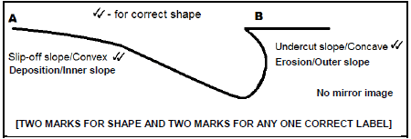 (2 x 2) (4)
1.6.5 SLOPE A – MOST SUITABLE FOR THE CAMPSITE
Has a gentle convex shape (2)
Gentle slope ideal for building and camping (2)
Easy access to river for fishing or collecting water (2)
Flow rate is lower and therefore safer (2)
Over time deposition will allow the campsite to increase in size (2)
Easier to launch small boats and canoes (2)
It creates a shallow point to access the river (2)
Soil is fertile therefore more vegetation (2)
More trees for shade (2)
SLOPE B
Constant erosion/undercutting results in concave/steep slope (2)
Undercutting leads to the formation of a river cliff which is unstable (2)
The position of camp sites will retreat and cause facilities to be damaged (2)
Reduced access to water (2)
Faster flowing water will be more dangerous (2)
[ANY FOUR] (4 x 2) (8)
[75]
QUESTION 2
2.1
2.1.1 D (1)
2.1.2 B (1)
2.1.3 A (1)
2.1.4 D (1)
2.1.5 A (1)
2.1.6 C (1)
2.1.7 B (1) (7 x 1) (7)
2.2
2.2.1 D/River system (1)
2.2.2 C/turbulent (1)
2.2.3 B/deposition (1)
2.2.4 A/permanent base level (1)
2.2.5 D/Abstraction (1)
2.2.6 D/Misfit stream (1)
2.2.7 A/Braided stream (1)
2.2.8 B/periodic (1) (8 x 1) (8)
2.3
2.3.1 A (1) (1 x 1) (1)
2.3.2 Air circulates in an anticlockwise (in the Northern Hemisphere) (2)
Direction of movement is North West (2)
Taiwan is in the Northern Hemisphere/North of the Equator (2)
[ANY ONE] (1 x 2) (2)
2.3.3 The name of this typhoon is Meranti (the 13th typhoon that season) (2)
(1 x 2) (2)
2.3.4 Storm surges cause coastal flooding (2)
Along the coastline which puts people's lives at risk/prevents loss of lives (2)
Heavy down pours of rain will result in flooding (2)
Low-lying areas most prone to flooding which puts peoples’ lives at risk (2)
Minimises damage and injuries (2)
These are destructive storms associated with strong winds (2)
Strong winds cause flying debris (2)
[ANY ONE] (1 x 2) (2)
2.3.5 Development of a steeper pressure gradient (2)
Stronger or higher wind speeds (2)
High sea surface temperatures will increase upliftment and cooling of air (2)
Increased latent heating as condensation increases which provides more energy for the typhoon (2)
Continuous large supply of moisture (2)
Rapid rising of warm moist air intensifies the low pressure centre (2)
Intense atmospheric instability (2)
Increase in upper air divergence (2)
[ANY TWO] (2 x 2) (4)
2.3.6 A large amount of rainfall would cause mudslides or landslides (2)
Mudslides/landslides destroy farmlands (2)
Mudslides/landslides destroy settlements (2)
Rock falls will result in a loss of life and damage to property (2)
Will result in bridges being washed away and reducing accessibility (2)
The regions inability to communicate will reduce the accessibility of services (2)
Roads that are washed away will leave communities inaccessible to emergency services (2)
Interruption of electricity supply (2)
Flooding of mountain streams will increase surface run-off and destroy valuable crops and increased stock losses (2)
Heavy rainfall will damage homes and leave people homeless (2)
Greater dependence on government services e.g. social/health (2)
Soil erosion/washed away fertile soil reduces the level of food security in the region (2)
Soil erosion silts up dams (2)
Disruption of vegetation/ecosystems/loss of biodiversity (2)
Holiday resorts are destroyed (2)
Reduce the amount of tourism in the area (2)
[May include positive impacts]
Major source of water for rivers/dams (2)
Provides water for irrigation/livestock/domestic/industrial use (2)
Renewal/upgrading of destroyed infrastructure (2)
Flushes out pollution/improves the water quality (2)
[ANY TWO] (2 x 2) (4)
2.4
2.4.1 A (1) (1 x 1) (1)
2.4.2 Rising warm air (convection currents) has a greater vertical dimension in A (2)
No evidence of subsiding air (2)
Inversion layer not visible in A (2)
Cold air is high above city (2)
A low lying inversion layer is evident at B (2)
Warm air is blocked from rising at B (2)
[ANY ONE] (1 x 2) (2)
2.4.3 Higher concentration of pollution trapped close to the earth's surface (2)
Pollution trapped close to the ground mixes with fog/ground based cloud (2)
(1 x 2) (2)
2.4.4 Convection/rising air disperses pollution to upper levels of the atmosphere (2)
No inversion layer close to surface to trap pollution (2)
[ANY ONE] (1 x 2) (2)
2.4.5 SUSTAINABLE SOLUTIONS TO LIMIT SMOG FORMATION IN CITY
Roof top gardens/green lungs (2)
More natural environments e.g. green belts within the city limits (2)
Taller chimneys to release pollution higher in the atmosphere (2)
Regulate industrial activity at night to reduce the concentration of emissions within the CDB (2)
Bylaws/restrictions to carbon emissions by various pollution producing industries in the city (2)
Penalties/Fines for exceeding smog restrictions by industries located closer to the city (2)
More decentralised industrial growth points away from the CBD (2)
Filters on chimneys to reduce toxicity of emissions (2)
Use of green/clean source of energy (2)
Car-pooling/lift clubs (2)
Filters/catalytic converters on motor vehicle exhaust pipes (2)
Hybrid/solar powered/electric/battery-operated vehicles (2)
Improved public transport/dedicated bus lanes will result in less private vehicles within the limits of the CBD (2)
Park-and-ride facilities (2)
Promote use of bicycles in city centre (2)
Pedestrianise the city centre (2)
Increased public awareness/education (2)
[ANY FOUR] (4 x 2) (8)
2.5
2.5.1 When you have a younger river flowing on an older landscape that has been exposed through erosion of the surface layer (1)
A stream pattern that does not match the underlying rock structure (1)
A stream that imposes itself on a new rock structure after erosion of the top layer (1)
[CONCEPT]
[ANY ONE] (1 x 1) (1)
2.5.2 Stream now cuts through hard exposed ridges (2) (1 x 2) (2)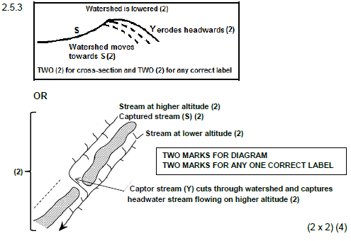
2.5.4 CHANGES IN THE CAPTURED STREAM DOWNSTREAM OF THE ELBOW OF CAPTURE
Decreased channel flow in river as its headwaters are captured (2)
Decreased velocity as wetted perimeter increases (2)
Loss in volume/velocity decreases the energy of the river/less energetic (2)
Loss in volume/velocity decreases its erosive ability (2)
River unable to carry its load/deposition increases (2)
River deposits its load on the river bed (2)
Small stream within a larger valley/misfit stream/narrower stream (2)
Less water, therefore stream discharge decreases (2)
River could dry up (2)
As headwaters are lost, the drainage basin decreases (2)
River has less water for plants/fish (2)
Reduced biodiversity/destruction of river ecosystem (2)
River has less water for people that depend on the river for survival (2)
[ANY FOUR] (4 x 2) (8)
2.6
2.6.1 Rejuvenated rivers are 're-energised' (1)
Display aspects of both vertical and horizontal erosion (1)
Rivers that actively erode downward again (1)
The carrying capacity of the river increases (1)
[ANY ONE] (1 x 1) (1)
2.6.2 Terraced slopes/river terraces (1)
New flood plain (1)
Valley within a valley (1)
Incised/entrenched meander (1)
[ANY TWO] (2 x 1) (2)
Stream at higher altitude (2) Captured stream (S) (2)
Stream at lower altitude (2)
Captor stream (Y) cuts through watershed and captures headwater stream flowing on higher altitude (2)
2.6.3 River capture increases the water volume (2)
Fast flowing tributary which joins the main river (2)
Sustained/prolonged increase in rainfall within a catchment area (2)
Climate change that results in an increased rainfall (2)
Tectonic shifts in the landscape (uplift) changes the base level of the river (2)
Drop in sea-level changes the base level of the river (2)
Sudden change in gradient (2)
Clearing of vegetation increase run-off (2)
[ANY TWO] (2 x 2) (4)
2.6.4 Incised meanders/entrenched meanders (2) (1 x 2) (2)
2.6.5 Construction of bridges will be more expensive and need to cover the width of the valley (2)
Steep slopes will make it difficult to build roads/railway lines (2)
It will be difficult to provide services (power/water) (2)
More time consuming to develop infrastructure (2)
Difficult to use heavy machinery in the construction of infrastructure (2)
[ANY ONE] (1 x 2) (2)
2.6.6 Meanders may undercut the terrace causing it to collapse/slope instability (2)
Terraces too high lying to access water to the farmed areas (2)
Steep terrace slopes limits access to terraces (2)
Narrow terraces limit cultivation (2)
No more flooding to deposit fertile silt (2)
At risk to mudslides/mudflows (2)
[ANY TWO] (2 x 2) (4)
[75]
SECTION B: RURAL AND URBAN SETTLEMENTS AND SOUTH AFRICAN ECONOMIC GEOGRAPHY
QUESTION 3
3.2
3.2.1 South Western Cape (1)
3.2.2 Coastal location/bordered by the ocean (sea)/have bays (1)
3.2.3 Durban-Pinetown/EThekwini Industrial Region (1)
3.2.4 Sugar cane (1)
3.2.5 A/South Western Cape (1)
3.2.6 B/Durban-Pinetown (1)
3.2.7 A/South Western Cape (1)
3.2.8 B/Durban-Pinetown/EThekweni (1) (8 x 1) (8)
3.3
3.3.1 The urban land set aside for a specific function/purpose (1)
[CONCEPT] (1 x 1) (1)
3.3.2 Central Business District (CBD) (1) (1 x 1) (1)
3.3.3 All main roads lead to the CBD/converge in the CBD (2)
Centrally located (2)
[ANY ONE] (1 x 2) (2)
3.1
3.1.1 B (1)
3.1.2 A (1)
3.1.3 A (1)
3.1.4 B (1)
3.1.5 A (1)
3.1.6 A (1)
3.1.7 B (1) (7 x 1) (7)
3.3.4 Increase in traffic congestion (2)
Results in overcrowding (2)
Increased air pollution levels (2)
High noise pollution levels (2)
More littering (2)
Urban heat island effect intensifies (2)
Higher probability of accidents (2)
Increase in crime (2)
Lack of parking facilities (2)
Shortage of space (2)
High land values (2)
High rental cost of office space (2)
More roads create more artificial surfaces which increases run-off (2)
Urban blight of the city because of higher usage of the city (2)
Destruction of the natural environment/ecosystems/habitats (2)
[ANY TWO] (2 x 2) (4)
3.3.5 HOW DO GREENBELTS REDUCE THE ENVIRONMENTAL PROBLEMS CAUSED BY ACCESSIBILITY?
Refer to environmental factors only
Controls greenhouse gases (2)
Reduces the effect of urban heat islands/lowers temperatures (2)
Cleans the air/purifies by absorbing carbon dioxide/reduces air pollution (2)
Carbon sink by releasing oxygen (2)
Reduces run-off (2)
Absorbs/reduces city noises and traffic sounds/buffers noise/filters noise (2)
Creates a habitat for other living organisms (2)
Creates a pleasing natural environment for recreational purposes (2)
Improves the aesthetics of the urban environment (2)
Greater biodiversity (2)
[ANY FOUR] (4 x 2) (8)
3.4
3.4.1 When some buildings in the city becomes run-down/dilapidated and are not fixed/maintained (1)
[CONCEPT] (1 x 1) (1)
3.4.2 Landlords do not maintain buildings (1)
Overcrowding of properties (1)
Future zone of expansion of CBD (1)
Intention to change original function of building (1)
Illegal occupation of buildings (1)
Sub-letting (1)
Poor service delivery (1)
[ANY ONE] (1 x 1) (1)
3.4.3 Deadline to move was extended (2)
Nowhere to go/no alternative accommodation (2)
Do not want to move elsewhere (2)
Sentimental value attached to house/community/familiar with the community (2)
Cannot afford to move elsewhere/no money to relocate (2)
They don’t want to be moved far from the city/place of work (2)
[ANY ONE] (1 x 2) (2)
3.4.4 Residents are forced to move out of the buildings that will be renewed (2)
Residents are forced to settle in new communities that they are not familiar with (2)
Residents level of access to amenities in the CBD will be reduced (2)
Residents will incur increased costs due to the movement (2)
They will be settled far distances out of the city (2)
Disruption of social networks/linkages/heritage/sentimental buildings (2)
Lack of consultation/excluded from decisions to effect urban renewal (2)
[ANY ONE] (1 x 2) (2)
3.4.5 Buildings in the transition zone are dilapidated (2)
Creates health and safety hazard (2)
Urban decay is highest in the transition zone (2)
To prevent urban decline that can spill over to the CBD (2)
To prevent vandalism/graffiti (2)
Residential buildings e.g. flats in the transition zone are mostly occupied illegally (2)
To prevent the influx of vagrants (2)
Most landlords do not maintain the buildings that they own in the transition zone (2)
To upgrade buildings/making buildings more aesthetically pleasing/improve the prestige of the city (2)
Many social ills (crime/prostitution/drug abuse/domestic violence) (2)
High land value but low building value (2)
To increase the property value (2)
To prevent loss of money for the city (2)
To attract more investors into the area (2)
To attract more tourists (2)
Facadism (preservation of the building frontage) (2)
Preserve the building heritage (2)
[ANY TWO] (2 x 2) (4)
3.4.6 Only people with a higher income can afford to stay here (2)
Excludes lower income earners (who don’t have affordability) (2)
Area will now have a higher status/prestige (2)
Value of property increases (2)
More costly to buy/rent (2)
Upkeep of property will increase (2)
Continuous gentrification will take place (2)
Higher levels of security and safety (increases the rentals which only higher income earners can afford) (2)
[ANY TWO] (2 x 2) (4)
3.5
3.5.1 Coega (1)
East London/ELIDZ (1)
Richards Bay/RBIDZ (1)
Dube Trade Port (DTP) (1)
Saldanha Bay (1)
[ANY ONE] (1 x 1) (1)
3.5.2 To attract foreign investments and increase exports (1) (1 x 1) (1)
3.5.3 Provide attractive service rebates/government incentives (water/electricity/
transport) (2)
Tax rebates/concessions (2)
Provide well-developed infrastructure (2)
Cheaper and open land (2)
Access to labour supply (2)
Access to harbours and transport links for export (2)
It is closer to export markets (2)
Duty free benefits on importing raw materials (2)
Attracts potential investors (2)
[ANY TWO] (2 x 2) (4)
3.5.4 Relieves pressure on infrastructure (2)
Less pollution (2)
Less pressure on services/prevents over-utilising of resources (water and electricity) (2)
Less traffic congestion (2)
Reduces rural-urban migration (2)
Reduces overcrowding (2)
[ANY TWO] (2 x 2) (4)
3.5.5 Providing job opportunities (2)
Up-skilling people (2)
Lowering of crime rates (2)
Poverty alleviation/better standard of living (2)
Improved infrastructure (2)
Improved service delivery (2)
Better housing (2)
Contributes to the local economy (2)
Industrialists are involved in social responsibility initiatives (2)
The multiplier effect/development of associated or linked industries (2)
[ANY TWO] (2 x 2) (4)
3.6
3.6.1 Increased (1) (1 x 1) (1)
3.6.2 Decrease in rank/Dropped seven places (1) (1 x 1) (1)
3.6.3 When all the people have access to nutritious (healthy) food (2)
(1 x 2) (2)
3.6.4 Food security enables growth and health in South Africa's population (2)
Enables South Africa to improve nutrition of its workforce (2)
Ensures that all sectors of the population are fed constantly/no food shortage (2)
Ensures higher productivity levels of inhabitants (2)
To prevent hunger and famine (2)
To prevent malnutrition/stunted growth/diseases (2)
A healthy population reduces the burden on the government/less expenditure on healthcare (2)
Increases life expectancy and labour force (2)
Reduces need to import food at high cost (2)
Lower food prices (2)
Outflow of capital from the country is reduced (2)
To prevent social uprisings (2)
[ANY TWO] (2 x 2) (4)
3.6.5 REASONS FOR LOW FOOD SECURITY INDEX IN SOUTH AFRICA
Natural
Drought conditions/natural disasters increased resulting in a drop in
production levels reducing the amount of food available (2)
Climate change has resulted in variable rainfall over most cultivation regions which has dramatically reduced production levels (2)
Pests and diseases decrease crops (2)
Soil erosion resulting in thin and poor soils/large areas have infertile soils (2)
Social/Services
Electricity supply is compromised and increased costs affects food production and food storage (2)
Lack of access to water supplies for irrigation (2)
Increased health risks/reduced life expectancy (HIV/AIDS) decreases the ability to produce food (2)
Poor transport facilities in rural areas make food less accessible (2)
Poor use of technology or research/poor farming methods/lack of skills (2)
Uncertainty because of land reform/failed land reform programmes result in land not being cultivated (2)
Population demand for food is greater than food supply (2)
Increase in farm murders drive farmers of their land (2)
Economical
Economic decline and foreign ratings creates an increasing inflation rate which increase the cost of food (2)
Increased rural-urban migration reduces food production (2)
High cost of food (2)
Lack of employment/poverty to buy expensive food (2)
Fluctuating food prices (2)
High production costs e.g. purchasing fertilisers (2)
Subsistence farming has a low productivity (2)
Lack of access to loans/lack of capital to invest in farming activities (2)
Not enough commercial farmers (2)
Farmers produce for the export market and not for the local market (trade policies) (2)
Misappropriation of funds for the development of farmers (2)
Processed food (e.g. tinning of food) is expensive (2)
[ANY FOUR] (4 x 2) (8)
[75]
QUESTION 4
4.1
4.1.1 B (1)
4.1.2 B (1)
4.1.3 B (1)
4.1.4 A (1)
4.1.5 A (1)
4.1.6 B (1)
4.1.7 A (1)
4.1.8 A (1) (8 x 1) (8)
4.2
4.2.1 C/Large-scale (1)
4.2.2 E/Intensive farming (1)
4.2.3 A/Urban agriculture (1)
4.2.4 B/Labour intensive (1)
4.2.5 F/Export market (1)
4.2.6 G/Home market (1)
4.2.7 D/Monoculture (1) (7 x 1) (7)
4.3
4.3.1 Market area from where an urban settlement/business draws customers (1)
[CONCEPT] (1 x 1) (1)
4.3.2 City larger/bigger/wider than the town (1)
OR
Town smaller/narrower than the city (1) (1 x 1) (1)
4.3.3 The order of the goods sold in a particular service area/order of services provided/degree of specialisation of services/goods (1)
Number of functions/goods that are offered (1)
Type of functions offered/goods sold (1)
Variety of goods/services offered (1)
Price of goods/services (1)
[ANY ONE] (1 x 1) (1)
4.3.4 Zone of competition/where people can choose which place to shop at (2)
Personal choice/convenience of where to go (2)
Travel to place which offers better services (2)
If there is little impact on travelling time and cost for the product they want to purchase (2)
Going to either town or city for another purpose and shopping while there (2)
En-route to place of work/residence (2)
Offering of cheaper goods/services (2)
Variety of goods offered (2)
For high order/speciality goods/services customers can choose to go to the city (2)
For low order/daily goods/services customers will most likely go to the town (2)
[ANY TWO] (2 x 2) (4)
4.3.5 Distance travelled (range) will depend on the order of the goods/service (2)
High order goods/services/consumer goods have a greater range and draw customers from farther away (2)
Low order goods/services/basic commodities/convenience goods have a shorter range therefore people not prepared to travel very far (2)
Cost of goods/services – the cheaper, the shorter the distance/the more expensive, the farther the distance (2)
[ANY TWO] (2 x 2) (4)
4.3.6 People not prepared to travel long distances to obtain lower order goods/services/convenience goods/functions (2)
More low order centres will exist to provide for the daily needs of people/goods/functions that are frequently needed (2)
Increased costs to obtain low order goods/services/functions if you have to travel to high order centres for daily needs (2)
Low order centres serve a small area (2)
High order goods and services are not required daily/less frequently (2)
Fewer outlets provide high order goods/services/functions/not regular use of services (2)
People are prepared to travel long distances to obtain high order goods/services/functions therefore fewer high order centres needed (2)
High order centres serve a large area (2)
Economic progression - as economic development takes place, some smaller centres will grow into larger centres (as number of goods/services/functions increases, that town will grow) (2)
[ANY TWO] (2 x 2) (4)
4.4
4.4.1 Drought/farm dried up/lack of rainfall (1)
Loss of property/unemployment (1)
Poor standards of living in the rural area (1)
[ANY ONE] (1 x 1) (1)
4.4.2 Higher standard of living (1) (1 x 1) (1)
4.4.3 Not all people have a higher standard of living evident in strip 4 (1)
Some people live in shacks/informal settlements (1)
Some poor living conditions (1)
High rate of unemployment (1)
[ANY ONE] (1 x 1) (1)
4.4.4 Employment/job opportunities (2)
Basic services (2)
Education/medical services (2)
Formal housing (2)
Cultural/recreational/entertainment/'bright lights' (2)
[ANY TWO] (2 x 2) (4)
4.4.5 MAKING PROVISION FOR AN INFLUX OF RURAL MIGRANTS
New low cost housing projects/to prevent housing shortages/curb the development of informal settlements (2)
Formalising the current informal settlements (2)
Improved infrastructure (2)
Improved basic services (2)
Money to install solar geysers (2)
Money to install water storage systems/JoJo Tanks (2)
Improved public transport (2)
Improved sanitation (2)
Access to education (2)
Regular waste removal (2)
Preventing spreading of diseases due to unhygienic living conditions (2)
Access to clinics (2)
Improved drainage systems (2)
Reskilling programs (2)
Improved crime prevention and policing (2)
Accessible social services (2)
Must create employment opportunities (2)
To maintain existing services (2)
To prevent poor service delivery protests (2)
Providing a better quality of life for inhabitants (2)
[ANY FOUR] (4 x 2) (8)
4.5
4.5.1 KwaZulu-Natal (1) (1 x 1) (1)
4.5.2 'The Dube Trade Port is set to be a major logistics platform for Southern Africa, as the Port of Durban provides connectivity to 53 international destinations and access to local distribution networks' (1)
OR
Connectivity/accessibility to rest of the world/global trade connections/ promoting exports (1) (1 x 1) (1)
4.5.3 Sugar (1)
Products related to sugar e.g. sweets/biscuits/chocolates (1)
Aluminium products (1)
Motor vehicles (1)
Oil (1)
Chemicals/paint (1)
Textiles (1)
Footwear (1)
Paper products (1)
Soap (1)
Ship building (1)
Rubber (1)
[ANY TWO] (2 x 1) (2)
4.5.4 Wide range of raw materials available (2)
Suitable climate to produce wide range of agricultural products (2)
Large skilled and unskilled labour force (2)
Large local market (2)
Access to other major industrial regions (2)
Well-developed infrastructure (2)
Availability of energy resources (electricity) (2)
Availability/reliability of water resources (2)
Flat land on the coastal plain (2)
Development of an international airport (2)
[ANY TWO] (2 x 2) (4)
4.5.5 AGRICULTURE ZONE
Supports agricultural production and increased yields (2)
Increases the raw materials used in industries (2)
Greater output from industries for local and international trade (2)
Supports further industrial growth/development of linked industries (2)
CARGO TERMINAL
Makes handling of high volumes easier (2)
Profits boosted due to better handling of cargo/less time wasted (2)
Importing of more raw materials to be used in industries (2)
More finished goods can be exported (2)
Supports further industrial growth/development of ancillary (support) industries (2)
Trade links can be expanded (2)
Attracts foreign investments (2)
[ANY FOUR. MUST REFER TO BOTH] (4 x 2) (8)
4.6 4.6.1 Concerned with the provision of services (1)
[CONCEPT] (1 x 1) (1)
4.6.2 Finance, real estate and business service activities (1)
(ACCEPT Construction) (1)
[ANY ONE] (1 x 1) (1)
4.6.3 FINANCE, REAL ESTATE AND BUSINESS ACTIVITIES
Gauteng is the economic hub of South Africa (2)
There are many Head Offices and businesses (2)
Concentration of these economic activities (2)
Office and business space readily available (2)
The Johannesburg Security/Stock Exchange (JSE) located here (2)
OR
CONSTRUCTION
Gauteng experiences rapid growth in economic development (2)
Industrial growth requires more factories (2)
Influx of businesses requires office space (2)
Influx of people requires housing (2)
Constant upgrading of older buildings/urban renewal projects (2)
Constant upgrading of infrastructure/well-developed infrastructure promotes construction industry (2)
[ANY ONE, DEPENDING ON ANSWER TO QUESTION 4.6.2] (1 x 2) (2)
4.6.4 It contributes a large percentage/more than 30% (2) (1 x 2) (2)
4.6.5 More profits are generated from the tertiary sector/tertiary products have a higher value (2)
Exporting primary products has a low profit margin/primary products has less value (2)
Tertiary sector is more indicative of the skill levels of the labour force (2)
Tertiary sector generates a more steady income as compared to the primary sector (2)
Tertiary activities less at risk to natural disasters (2)
Climatic changes put farming products at risk (2)
Higher salaries are earned which strengthens buying power (2)
Tertiary activities has a greater potential to attract foreign investments (2)
To protect raw materials from being depleted/destroyed (2)
[ANY TWO] (2 x 2) (4)
4.6.6 Transport/airports increases accessibility in terms of international links/promotes international trade (2)
Gautrain provides alternative means of accessibility (2)
Good transport networks connect Gauteng with rest of SA/promotes domestic trade (2)
Allows for the easy transportation of goods (2)
Transport networks attracts foreign investment/promotes further growth (2)
Links Gauteng to harbours and facilitates international trade (2)
Rapid transport services to transport people to work and back (2)
Promotes tourist-related industries (2)
Increases access to tertiary services (2)
Leads to growth in tertiary sector (2)
[ANY TWO] (2 x 2) (4)
[75]
GRAND TOTAL: 225