GEOGRAPHY PAPER 1 GRADE 12 MEMORANDUM - NSC PAST PAPERS AND MEMOS FEBRUARY/MARCH 2016
Share via Whatsapp Join our WhatsApp Group Join our Telegram GroupGEOGRAPHY P1
FEBRUARY/MARCH 2016
MEMORANDUM
NATIONAL SENIOR CERTIFICATE
GRADE 12
SECTION A: CLIMATE, WEATHER AND GEOMORPHOLOGY
QUESTION 1
1.1.1 Tropical Cyclone (1)
1.1.2 Low Pressure System (1)
1.1.3 Late Summer and Early Autumn (1)
[ACCEPT EITHER]
1.1.4 Tropical Easterlies (1) OR South East Trade winds (1)
1.1.5 Hadley Cell (1)
1.1.6 Reunion (1)
1.1.7 This is the 5th cyclone to have happened in that season (1)
1.1.8 Cumulonimbus (1) (8 x 1)
(8)
1.2.1 Watershed (1) OR Water-divide (1)
1.2.2 Interfluve (1)
1.2.3 Source (1)
1.2.4 Confluence (1)
1.2.5 Tributary/Stream (1)
1.2.6 Lower (1)
1.2.7 Mouth (1) (7 x 1)
(7)
1.3.1 Extra-tropical cyclone/Frontal depression/Temperate cyclones (1) (1 x 1) (1)
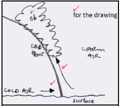
1.3.2 The area is the cold sector (1) which is characterised by the cold dense air from the Polar regions (1) (2 x 1) (2)
1.3.3 Cross-Section of the Cold Front:
 (4 x 1) (4)
1.3.4 Between 30° and 60° north and south of the equator (2) (1 x 2) (2)
1.3.5
- The cold and warm fronts are fully developed (2)
- The cold and the warm sectors are also fully developed. (2)
- The cold air behind the cold front is moving under the warm air. (2)
- The warm air behind the warm front rising above the cooler air ahead of it (2)
- The cold front has not caught up to the warm front (2)
- An occlusion has not begun (2)
[ANY ONE] (1 x 2) (2)
1.3.6 The South Indian High Pressure acts as a blocking high (2)
Anti-clockwise flow causes the mid-latitude cyclone to move further south and then East; where it results in an occlusion and dissipates over the Indian Ocean (2) (2 x 2) (4)
1.4.1
- South Atlantic Anticyclone (1) or St Helena High (1)
- Kalahari Anticyclone (1) or Continental High (1)
- South Indian Anticyclone (1) or Mauritius High (1) (3 x 1) (3)
1.4.2
 (4 x 1) (4)
1.4.3 THE IMPACT OF ITCZ ON ANTICYCLONES
- The Earth is tilted 23½° to the vertical, as it faces the sun (2)
- This causes the ITCZ to shift north and south of the equator from season to season (2)
- Pressure belts follow the apparent migration of the sun (2)
- In summer the 3 anticyclones are located further south (2)
- In winter the 3 anticyclones are located further north (2)
[ANY FOUR] (4 x 2)
(8)
1.5.1 The ratio between the total length of all the streams in a river system and the area of the drainage basin that it drains (1)
[Concept] (1 x 1) (1)
1.5.2
- Dry season (1)
- Rainy season (1) (2 x 1) (2)
1.5.3 In the wet season drainage density will be high due to high rainfall (often soil is saturated) and a high rate of run-off occurs (2)
In the dry season the drainage density will be low due to low rainfall and high rate of infiltration occurring (2) (2 x 2) (4)
1.5.4 IMPACT OF DRAINAGE DENSITY ON DRAINAGE BASIN ORDER
- In the wet season there will be higher rainfall, which leads to higher volumes of water (2) leading to more 1st and 2nd order streams/rivers (2)
- The area will have high rates of run-off (2), as soils will be saturated (2)
- This increases the drainage basin order (2)
- In the dry season there will be less run-off due to less rainfall (2)
- Less 1st and 2nd order streams will be found (2)
- The area will have higher levels of infiltration creating lower drainage densities (2)
- This decreases drainage basin order (2)
[ACCEPT OTHER REASONABLE ANSWERS] (4 x 2)
(8)
1.6.1 Braided (1) (1 x 1) (1)
1.6.2 Higher rates of deposition (1) OR Lower rates of transportation (1)
[ANY ONE] (1 x 1) (1)
1.6.3 Middle to Lower Course (1) (1 x 1) (1)
1.6.4
- It occurs when a river flows on a gentle gradient (2)
- The river loses energy and starts depositing the load it carries (2)
- The path of the river is then blocked by alluvium (2)
- The river splits into separate channels that flow around islands of alluvium (2)
[ANY TWO] (2 x 2) (4)
1.6.5
- The trees roots would lower stream discharge by absorbing the water (2)
- Trees hinders the flow of water and discharge increases (2)
- The trees would promote higher rates of infiltration rather than discharge (2)
[ANY TWO] (2 x 2) (4)
1.6.6
- The features will be temporary (2)
- Most of the rivers in the interior of the country are periodic rivers (2)
- They flow only during the rainy season, usually during summer in the interior of South Africa (2)
Reduced run-off takes place and tributaries decrease (2)
[ANY ONE REASON FOR GIVEN ANSWER] (2 x 2) (4)
[75]
QUESTION 2
2.1.1 Winter (1)
2.1.2 X (1)
2.1.3 Y (1)
2.1.4 X (1)
2.1.5 Y (1)
2.1.6 B (1)
2.1.7 Less (1)
2.1.8 Y (1) (8 x 1)
(8)
2.2.1 Upper Course (1)
2.2.2 Source (1)
2.2.3 Vertical/ downward erosion (1)
2.2.4 Waterfall (1)
2.2.5 Headward erosion (1)
2.2.6 Undercut slope (1)
2.2.7 Ungraded (1) (7 x 1)
(7)
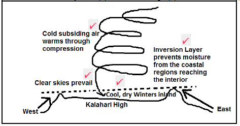
2.3.1 The Kalahari High Pressure can be seen over South Africa (1) and the coastal low along the east coast (1)
The anticlockwise circulation of air (1)
[ANY TWO] (2 x 1) (2)
2.3.2 The Kalahari High is more dominant over South Africa in winter (1)
The coastal low moves easier along the coast during winter (1)
A steep pressure gradient exists between the interior and the coast (1)
[ANY TWO] (2 x 1) (2)
2.3.3 The air has heated by 1°C/100m of descent – according to the dry adiabatic lapse rate – and increased the air temperature (2)
Any moisture is evaporated as the air heats up through descent lowering the humidity (2) (2 x 2) (4)
2.3.4
- Winter in South Africa is generally dry (as a result of little or no rain), so this warm, dry wind can cause veld fires (2)
- People are susceptible to the risk of runaway fires – putting people's lives in danger (2)
- Farmers lose crops and suffer financially as a result of this environmental hazard (2)
- Urban settlements on mountain slopes are threatened (2)
- People suffer from the hot conditions (2)
- During berg winds people suffer from discomfort and skin irritations (2)
[ANY THREE. ACCEPT ANY OTHER REASONABLE ANSWERS] (3 x 2) (6)
2.4.1 The temperature values increase with an increase in height (1)
[Concept] (1 x 1) (1)
2.4.2 Temperature increases with height before it decreases (1) (1 x 1) (1)
2.4.3 The smog is trapped by the inversion layer (2) (1 x 2) (2)
2.4.4
- It causes respiratory infections (accept examples) (2)
- Visibility is poor as a result of smog (2)
- Aesthetic appeal of good views over the landscape are reduced (2)
- Smog can also dirty buildings and architecture (2)
[ANY TWO. ACCEPT OTHER REASONABLE ANSWERS] (2 x 2) (4)
2.4.5 SUSTAINABLE METHODS TO REDUCE SMOG
- Install filters in stacks/chimneys to trap pollution before it enters the atmosphere (2)
- Build factories further away from cities or residential areas (2)
- Strict land-use zoning bylaws to prevent industrial development in cities (2)
- Install higher smoke stacks/chimneys to release pollutants above inversion layer (2)
- Reduce industrial activities at night time when inversion layer is close to the Earth's surface (2)
- Strict regulations regarding the quantity of pollutants that may be emitted (2)
- Increase vegetation to absorb carbon dioxide (2)
[ANY FOUR. ACCEPT OTHER REASONABLE ANSWERS] (4 x 2)
(8)
2.5.1 S: Captor Stream (1)
Y: Captured Stream (1) (2 x 1) (2)
2.5.2 A: Elbow of capture (1)
B: Wind gap (1) (2 x 1) (2)
2.5.3
- Higher rainfall causing increased headward erosion (2)
- Larger stream volume increase erosion (2)
- S is flowing through softer rock (2)
- S has a steeper gradient (2)
[ANY TWO] (2 x 2) (4)
2.5.4 THE IMPACT OF RIVER CAPTURE ON THE VOLUME OR WATER AND EROSIVE ABILITY
River B
The headwaters of B is captured (2)
The volume of water in B will decrease (2)
The abovementioned reduces the erosive ability (2)
It will become a misfit stream (2)
River S
River S captured the headwaters of river B (2)
Water added to river S increases its volume (2)
The abovementioned increases the erosive ability (2)
The river becomes rejuvenated (2)
[ANY FOUR. MUST REFER TO BOTH RIVER B AND RIVER S] (4 x 2)
(8)
2.6.1 Over-exploitation means to overuse and potentially destroy a resource (1)
[Concept] (1 x 1) (1)
2.6.2 A catchment area is the whole drainage basin, where a river system is found/the entire area drained by a river system (1)
[Concept] (1 x 1) (1)
2.6.3
- Alien plants reproduce at a high rate (2)
- Alien plants take over indigenous vegetation (2)
- These plants use too much water (2)
- By removing alien vegetation, less water will be used up (2)
[ANY TWO. ACCEPT OTHER REASONABLE EXPLANATION] (2 x 2)
(4)
2.6.4
- Wetlands are a natural storage place for water and supply water to drainage basins (2)
- Wetlands help to purify water (2)
- Water will be available during dry times in a wetland (2)
[ANY ONE. ACCEPT OTHER REASONABLE ANSWERS] (1 x 2)
(2)
2.6.5
- Slows down flow of water (2)
- Allows for infiltrations (2)
- Maintains groundwater levels (2)
- Plant roots anchor soil (2)
- Prevents erosion plus silting of rivers (2)
- Prevent sheet flow plus flooding (2)
[ANY TWO. ACCEPT OTHER REASONABLE EXPLANATION] (3 x 2) (6)
[75]
SECTION B: RURAL AND URBAN SETTLEMENTS AND SOUTH AFRICAN ECONOMIC GEOGRAPHY
QUESTION 3
3.1.1 rural (1)
3.1.2 village (1)
3.1.3 flat land(1)
3.1.4 machines (1)
3.1.5 nucleated (1)
3.1.6 grains (1)
3.1.7 unifunctional (1) (7 x 1)
(7)
3.2.1 C mining (1)
3.2.2 G manufacturing (1)
3.2.3 H international trade (1)
3.2.4 A information technology (1)
3.2.5 F vegetable garden (1)
3.2.6 D local trade (1)
3.2.7 I sugar cane plantation (1)
3.2.8 B roads, railway and communication (8 x 1)
(8)
3.3.1
Urbanisation is the process whereby the percentage of people living in the urban area increases (1)
[Concept] (1 x 1) (1)
3.3.2 Approximately 60% (1) (1 x 1) (1)
3.3.3 The natural population growth (1) and
Further migration of people to cities (1) (2 x 1) (2)
3.3.4
- Overcrowding (1)
- Traffic congestion (1)
- Over utilisation of urban infrastructure (2)
- Higher levels of unemployment (1)
- Higher levels of poverty (1)
- Higher levels of crime (1)
- Increase in anti-social behaviour (1)
[ANY FOUR. ACCEPT OTHER] (4 x 1) (4)
3.3.5
- Landlords neglect the maintenance of their buildings (2)
Oversubscribed tenants/sub-renting(2)
Tenants neglect the upkeep of buildings (2)
[ANY TWO. ACCEPT OTHERS] (2 x 2) (4) - Urban renewal through restoration (2)
Revamping of community services and amenities (2)
By laws to deal with delinquent landlords (2)
City Improvement Districts (CIDs), where a whole area of a city is improved to create a better environment (2)
[ANY TWO ACCEPT OTHERS] (2 x 2) (4)
3.4.1 An informal settlement is a grouping of buildings without proper infrastructure or services and amenities (like running water; sanitation and electricity) (1)
[Concept] (1 x 1) (1)
3.4.2 Minimum increase of 0,4 % (2) (1 x 2) (2)
3.4.3 More job opportunities (1) (1 x 1) (1)
3.4.4
- Houses poorly constructed with unconventional building materials (2)
- Lack of proper drainage facilities (2)
- High levels of pollution (2)
- Litter (2)
- High density dwellings (2)
- No/few gardens (2)
[ANY ONE. ACCEPT OTHER] (1 x 2) (2)
3.4.5 SOCIAL PROBLEMS AND VULNERABILITY
Social Problems
- Few stimulating activities to keep youth entertained (2)
- Often leads to drug and alcohol abuse (2)
- Many people are unemployed (2)
- Crime rates high as a result (2)
- Unhygienic conditions (2)
Vulnerability
- Fewer law enforcement officers available (2)
- Lack of electricity makes informal settlements darker at night (2)
- People in informal settlements are not safe at night (2)
- Rape, murder and other crimes easily committed here (2)
- Risk of shack fires (2)
[ANY FOUR. MUST REFER TO BOTH POINTS OF SOCIAL PROBLEMS AND VULNERABILITY. ACCEPT OTHER] (4 x 2)
(8)
3.5.1 Exported (1) (1 x 1) (1)
3.5.2 Increased (1) (1 x 1) (1)
3.5.3 Citrus fruits (1) (1 x 1) (1)
3.5.4 Manufacturing a product from a raw material makes it more valuable (2) (1 x 2)
3.5.5 South Africa close relationship with many African countries (2)
High quality of agricultural products
Reliability in provision
Agricultural products relatively cheap (2)
[ANY FOUR. ACCEPT OTHER] (2 x 2) (4)
3.5.6
- It provides employment opportunities (2)
- It earns foreign exchange (2)
- Contributes to the GDP of the country (2)
- Promotes the establishment of infrastructure (2)
- Provides raw materials to the manufacturing industry (2)
- It leads to food security and imports will be less (2)
[ANY THREE. ACCEPT OTHER] (3 x 2) (6)
3.6.1 The informal sector is the part of our economy that does not pay tax or is not necessarily registered as a company (1)
[Concept] (1 x 1) (1)
3.6.2 There is a correlation between the unemployment rate and the percentage of people employed as informal traders (2)
As unemployment increases, so too does the proportion of people working in the informal sector increase (2)
[ANY ONE] (1 x 2) (2)
3.6.3
- Developing countries have higher population numbers and lower levels of available employment (2)
- Some people have to make a living working for themselves by selling goods informally (2)
- People are uneducated and less skilled (2)
- Unskilled labourers cannot be absorbed into the labour force easily (2)
[ANY ONE. ACCEPT OTHERS] (1 x 2) (2)
3.6.4 More income would be created from the tax companies would need to pay (2)
More formal job creation (2)
[ANY ONE] (1 x 2) (2)
3.6.5 EMPOWERMENT OF INFORMAL TRADERS
- Granting the same rights and privileges of formal business (2)
- Loans and capital being provided to small businesses or entrepreneurs (2)
- Financing would facilitate business development and growth (2)
- Provision of facilities to informal traders could provide a more sustainable platform in which businesses can function (2)
- Education and training around basic business skills and financial management (2)
- Partnering with established businesses (2)
[ANY FOUR. ACCEPT OTHER REASONABLE ANSWERS] (4 x 2) (8)
[75]
QUESTION 4
4.1.1 Settlement (1)
4.1.2 Situation (1)
4.1.3 Site (1)
4.1.4 Wet-point settlement (1)
4.1.5 Metropolis (1)
4.1.6 A gap town (1)
4.1.7 Break-of-bulk (1)
4.1.8 Bridge town (1) (8 x 1)
(8)
4.2.1 Small-scale (1)
4.2.2 Food Insecurity (1)
4.2.3 Nationalisation (1)
4.2.4 Secondary (1)
4.2.5 Ubiquitous (1)
4.2.6 Centralisation (1)
4.2.7 Bridge (1) (7 x 1)
(7)
4.3.1 Sphere of influence is area around a settlement from which it attracts customers (1)
Range is the furthest distance people are prepared to travel from to enjoy a particular service (1) (2 x 1) (2)
4.3.2 Car sales (1) (1 x 1)
4.3.3 People are willing to travel much further to buy a car than they are to buy essentials like bread/ milk (1)
Buying a car is an important aspect that happens once in a long while, so people are prepared to travel greater distances for the right model and type of car (1)
[ANY ONE] (1 x 2) (2)
4.3.4 Car sales would need a larger threshold population, to make their business sustainable and viable for profit (2) (1 x 2) (2)
4.3.5 It has a smaller range (2)
It has a small sphere of influence (2) (2 x 2) (4)
4.3.6 Higher order goods and services are found in B, compared to surrounding areas (2)
People are willing to travel further to B, to buy a specialised product or service (2)
People travel short distances to take advantage of low order goods and services (like milk etc.) (2) (2 x 2) (4)
4.4.1 Central Business District (CBD) (1) (1 x 1)
4.4.2 Expansion of the CBD in an uneven manner (2) (1 x 2) (2)
4.4.3 Cheaper land (2) closer to industries (2)
Easy for some workers to walk to work (2)
[ANY ONE] (1 x 2) (2)
4.4.4 Access via roads – suit the motorists (2)
Open land and space for a large mall, with parking and underground parking (2)
Close to outlying residential areas (clientele and a market-base) (2)
[ANY ONE] (1 x 2) (2)
4.4.5 RELOCATION OF BUSINESSES
- Crime and grime in the inner-city (2)
- Forces many businesses to relocate to safer and cleaner; more well maintained outlying business districts like at C (2)
- Very expensive land and rentals in A (2)
- Initially causes businesses to relocate to cheaper land rentals at C (2)
- Overcrowded at A (2)
- Traffic congestion at A (2)
- Reduced access at A (2)
- Lack of parking at A (2)
- Limited expansion prospects at A (2)
[ANY FOUR – ACCEPT OTHERS] (4 x 2)
(8)
4.5.1 Mpumalanga (1) (1 x 1)
4.5.2 ESKOM (1)
SASOL (1) (2 x 1) (2)
4.5.3 Land degradation (2) OR
Opencast mining an eyesore (2)
Air pollution from the burning of coal to generate electricity (2)
[ANY TWO – ACCEP OTHER] (2 x 2) (4)
4.5.4 RECTIFYING ENVIRONMENTAL INJUSTICES
- Land mined as open cast coal mines need to be rehabilitated (2)
- Re-vegetation and the restoration of local fauna in the area where mining occurred must be monitored (2)
- Applying the polluter pays principle and fining companies responsible for high levels of air pollution (2)
- Applying scrubbing and clean technology to smoke stacks (2)
- Offsetting carbon footprints with carbon credits (2)
- Planting of more trees to offset carbon emissions (2)
[ANY FOUR – ACCEPT OTHERS] (4 x 2) (8)
4.6.1 Eastern Cape (1) (1 x 1) (1)
4.6.2 11 500 hectares (1) (1 x 1) (1)
4.6.3 Port of Ngqura (1) (1 x 1) (1)
4.6.4 Being a modern, deep water port - it can accommodate larger ships (2)
Many more ships can be accommodated at once(2)
[ANY ONE] (1 x 2) (2)
4.6.5 Renewable energy available – wind farm is 30 minutes away (2)
Supplements conventional power supplies (2)
[ANY TWO – ACCEPT OTHERS] (2 x 2) (4)
4.6.6
- Within 15 minutes of road, rail, air and sea transport - accessibility (2)
- Close to energy supply - 30 minute drive to biggest wind energy generating farm in South Africa (2)
- Access to 3 sea ports (PE, NGQURA and East London) (2)
- Close to a huge logistics zone (2)
- Availability of skilled/unskilled labour (2)
- Availability of space (2)
[ANY THREE – ACCEPT OTHERS] (3 x 2) (6)
[75]
TOTAL: 225