GEOGRAPHY PAPER 2 GRADE 12 QUESTIONS - PAST PAPERS 2017 JUNE
Share via Whatsapp Join our WhatsApp Group Join our Telegram GroupGEOGRAPHY PAPER 2
GRADE 12
NATIONAL SENIOR CERTIFICATE
JUNE 2017
RESOURCE MATERIAL
- An extract from topographic map 2829 AC HARRISMITH.
- Orthophoto map 2829 AC 3 HARRISMITH.
- NOTE: The resource material must be collected by the schools for their own use.
INSTRUCTIONS AND INFORMATION
- Write your NAME and GRADE in the space provided on the cover page.
- Answer ALL the questions in the spaces provided in this question paper.
- You are provided with a 1:50 000 topographic map (2829 AC HARRISMITH) and an orthophoto map (2829 AC 3 HARRISMITH) of a part of the mapped area.
- You MUST use the graph paper provided for drawing the cross-section. DO NOT remove the graph paper from the answer sheet.
- You must hand in the topographic map and the orthophoto map to the invigilator at the end of this examination session.
- You must use the blank page at the back of this paper for all rough work. DO NOT detach this page from the question paper.
- Show ALL calculations and formulae, where applicable. Marks will be awarded for these.
- Indicate the unit of measurement in the final answer of calculations. Ensure that units are maintained throughout ALL your calculations and final answer.
- You may use a non-programmable calculator.
- A glossary of some of the English and Afrikaans words and their translations appears below.
GLOSSARY
(SOME OF THESE ENGLISH TERMS OR THEIR AFRIKAANS TRANSLATIONS MAY APPEAR ON THE MAPS.)
| ENGLISH | AFRIKAANS |
| Landing strip Furrow Caravan Park Diggings Sewerage works Hot Springs Nature reserve | Vliegveld Voor Karavaanpark Uitgrawings Rioolwerke Warmwaterbronne Natuurreservaat |
GENERAL INFORMATION ON HARRISMITH
| Harrismith is a large town in the Free State province of South Africa. It was named after Sir Harry Smith, a 19th century British governor of the Cape Colony. It is situated by the Wilge River, alongside the N3 highway, about midway between Johannesburg, about 300 km to the north-west, and Durban to the southeast. The town is located at the junction of the N5 highway, which continues westward towards the provincial capital Bloemfontein, some 340 km to the south-west. This important crossroads in South Africa's land trade routes is surrounded by mesas and buttes. It is located at the base of one of these called Platberg (i.e. "flat/flat-topped mountain" in Afrikaans). 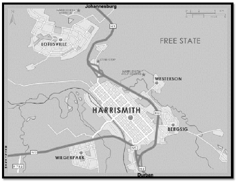 Coordinates: 28o17’00”S 29o08’00’’E / 28o17.0’S 29o08.0’E |
QUESTION 1: MULTIPLE-CHOICE QUESTIONS
The questions below are based on the 1:50 000 topographic map 2829AC HARRISMITH, as well as the orthophoto map of a part of the mapped area. Various options are provided as possible answers to the following questions. Choose the answer and write only the letter (A to D) in the block next to each question.
1.1 The topographic map sheet 2829 AC Harrismith shows part of …
- Gauteng.
- KwaZulu-Natal.
- Free State.
- Mpumalanga.
1.2 According to the topographic map, which neighbouring town lies in the southwesterly direction of Harrismith?
- Kestell
- Wilgerpark
- Witsieshoek
- Warden
1.3 The wind pump in block D4 on the topographic map lies at an altitude of … meters above sea-level.
- 1188
- 1660
- 1652
- 1640
1.4 The building labelled 1 on the orthophoto map is a …
- hotel.
- school.
- hospital.
- factory.
1.5 The country that lies south west of Harrismith is …
- Lesotho.
- Swaziland.
- Mozambique.
- Namibia.
1.6 In the urban hierarchy, Harrismith would be classified as a …
- city.
- country town.
- metropolitan area.
- primate metropolitan area.
1.7 The orthophoto map of Harrismith is a … photograph with a map scale of 1 : 10 000.
- vertical
- high oblique
- low oblique
- horizontal
1.8 The location (co-ordinates) of the spot height 1651 in block B1 is …
- 28°16'44"E 29°00'15"S / 28°16.7’E 29°00.3’S.
- 29°00'05"E 29°00'45"S / 29°00.1’E 29°00.3'S.
- 28°16'44"S 29°00'15"E / 28°16.7’S 29°00.3’E.
- 28°15'44"S 29°01'15"E / 28°15.7’S 29°01.3'E.
1.9 On the orthophoto map, the Basuto Hill marked 2 lies in block … on the topographic map.
- B7
- C8
- D7
- C7
1.10 The area marked 3 (WILGERPARK) on the orthophoto map is an example of a/an … residential area.
- high-income
- low-income
- middle-income
- informal
1.11 The map projection used on the Harrismith orthophoto map is a/an … projection.
- Lambert
- Mercator
- Gauss conformal
- Universal transverse
1.12 The land use labelled 4 on the orthophoto map is mainly …
- recreational.
- industrial.
- cultivation.
- plantation.
1.13 The Wilgerivier can be described as a/an … river.
- periodic
- permanent
- episodic
- exotic
1.14 The length of the dam wall in block G7 is … meters.
- 150
- 0.3
- 1.5
- 0.15
1.15 WILGERPARK (block C7/8) residential area is dominated by a/an … street pattern.
- radial
- planned irregular
- gridiron
- unplanned irregular
(15 × 1) [15]
QUESTION 2: MAPWORK CALCULATIONS AND TECHNIQUES
2.1 Use the linear scale to determine the distance in kilometres between the R74 road junction (block G4) and Witsieshek. (3 × 1) (3)
2.2 2.2.1 Draw a cross-section from points 5 and 6 on the orthophoto map. Use a vertical scale of 4 mm to represent 5 meters. Use the provided graph paper. Do not DETACH/REMOVE the graph paper from the answer sheet. (4 × 1) (4)
2.2.2 On your cross-section, label the following:
- Power line
- Wilgerivier
- Railway (3 × 1) (3)
2.2.3 Write down the vertical scale as a ratio scale. (1 × 1) (1)
2.2.4 The vertical exaggeration of the cross-section drawn in QUESTION 2.2.1 is 8 times. What does this answer mean? (1 × 1) (1)
2.3 The scale of the topographic map is 1 : 50 000. Explain what this ratio scale means. (1 × 1) (1)
2.4 Calculate the magnetic bearing of spot height 1737 (block E2) from trigonometric station 3 (block E5) for 2017.
Show ALL your calculations. Marks will be awarded for calculations.
Formula: Magnetic Bearing =Mean Magnetic Declination + True Bearing (7)
[20]
QUESTION 3: APPLICATION AND INTERPRETATION
3.1 Refer to the topographic map and answer the following questions:
3.1.1 Identify the drainage density found in block F1. (1 × 1) (1)
3.1.2 Describe TWO possible causes found in block F1 that lead to the formation of drainage density mentioned in QUESTION 3.1.1. (2 × 2) (4)
3.2 Locate the residential area at 7 on the orthophoto map.
3.2.1 Does the settlement represent a high or low income area? (1 × 1) (1)
3.2.2 Provide ONE reason to support your answer to QUESTION 3.2.1. (1 × 2) (2)
3.3 Refer to the hospital at 8 on the orthophoto map.
3.3.1 In which land-use zone is the hospital found? (1 × 1) (1)
3.2.2 Provide ONE orthophoto evidence to justify your answer to QUESTION 3.3.1. (1 × 2) (2)
3.4 Use the orthophoto map as well as the topographic map to answer questions below.
3.4.1 Identify the dominant street pattern at Harrismith CBD. (1 × 1) (1)
3.4.2 Give ONE advantage and ONE disadvantage of the street pattern identified in QUESTION 3.4.1.
Advantage:
Disadvantage:
(2 × 2) (4)
3.5 Find the industrial area marked 9 on the orthophoto map. 3.5.1 Classify the industrial area as heavy or light industry. (1 × 1) (1)
3.5.2 With reference to orthophoto and topographic map evidence, comment on the suitability of the location of the industry referred to in QUESTION 3.5.1.
(2 × 2) (4)
3.6 Refer to block D/E6 on the topographic map.
3.6.1 Identify the fluvial landform feature labelled A. (1 × 1) (1)
3.6.2 Identify the stage in which Nuwejaarspruit is (block D/E 6). (1 × 1) (1)
3.6.3 Suggest ONE map evidence to answer to QUESTION 3.6.2. (1 × 1) (1)
3.7 Refer to block H1 on the topographic map.
Identify the human-made feature, which is used to regulate (control) the flow of water of Nuwejaarspruit. (1 × 1) (1)
[25]
QUESTION 4: GEOGRAPHICAL INFORMATION SYSTEMS (GIS)
4.1 Data in GIS can be gathered from a number of sources. Differentiate between
the following data sources used in GIS.
4.1.1 Primary data: (1 × 1) (1)
4.1.2 Secondary data: (1 × 1) (1)
4.2 Is the topographic map of Harrismith a vector or raster map? (1 × 1) (1)
4.3 Justify your answer to QUESTION 4.2. (1 × 2) (2)
4.4 Explain why the orthophoto map of Harrismith has a high spatial resolution. (1 × 2) (2)
4.5 Refer to block H9 and answer the following questions:
4.5.1 Suggest THREE data layers that the farmer considered before establishing his farm in this specific area (block H9). (3 × 1) (3)
4.5.2 Provide a reason for the choice of ONE layer made in QUESTION 4.5.1. (1 × 2) (2)
4.6 Name and explain the GIS process that the farmer used to decide on the location of his farm (block H9).
4.6.1 GIS process: (1 × 1) (1)
4.6.2 Explanation: (1 × 2) (2)
[15]
TOTAL: 75
GRAPH PAPER FOR QUESTION 2.2. (DO NOT REMOVE)