GEOGRAPHY GRADE 12 QUESTIONS - NSC PAST PAPERS AND MEMOS JUNE 2022
Share via Whatsapp Join our WhatsApp Group Join our Telegram GroupINSTRUCTIONS AND INFORMATION
- This question paper consists of FOUR questions.
QUESTION 1: Climate and Weather (40)
QUESTION 2: Geomorphology (40)
QUESTION 3: Settlement (40)
QUESTION 4: Geographical Skills and Techniques (30) - Answer all FOUR questions.
- All diagrams are included in the QUESTION PAPER.
- Leave a line between subsections of questions answered.
- Start EACH question at the top of a NEW page.
- Number the questions correctly according to the numbering system used in this question paper.
- Do NOT write in the margins of the ANSWER BOOK.
- Draw fully labelled diagrams when instructed to do so.
- Answer in FULL SENTENCES, except when you have to state, name, identify or list.
- Units of measurement MUST be indicated in your final answer, e.g. 1 020 hPa, 14 °C and 45 m.
- You may use a non-programmable calculator.
- You may use a magnifying glass.
- Write neatly and legibly.
SPECIFIC INSTRUCTIONS AND INFORMATION FOR QUESTION 4
- A 1 : 50 000 extract of the topographic map 2820CB AUGRABIES and a
1 : 10 000 orthophoto map 2820CB 7 AUGRABIES are provided. - The area demarcated in RED/BLACK on the topographic map represents the area covered by the orthophoto map.
- Show ALL calculations. Marks will be allocated for this.
- You must hand in the topographic and the orthophoto map to the invigilator at the end of this examination session.
QUESTION 1: CLIMATE AND WEATHER
1.1 The sketch below illustrates the cross-section and weather characteristics of a mid-latitude cyclone in its mature stage.
Various options are provided as possible answers to the following questions. Choose the answer and write only the letter (A–D) next to the question numbers (1.1.1 to 1.1.5) in the ANSWER BOOK, for example 1.1.6 D.
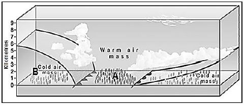
1.1.1 The area at A will be impacted by … in the southern hemisphere.
- the cold front
- the warm front
- both the cold and warm front
- neither the cold nor warm front
1.1.2 The air mass at B originated from the … winds.
- westerly
- equatorial
- polar
- trade
1.1.3 When the cold front joins the warm front the mid-latitude cyclone is in the … stage.
- wave
- frontal
- occlusion
- warm sector
1.1.4 Air pressure will … from A to B.
- increase
- decrease
- stagnate
- back
1.1.5 A list of reasons as to why the cold air/sector moves faster than the warm air/sector is provided below:
- The cold air behind the cold front
- The cold air is denser
- Stronger pressure gradient
- Heavy rainfall at the warm front
Which ONE of the following combinations are the reasons why the cold front moves faster than the warm front?- (i) and (ii)
- (iii) and (iv)
- (i) and (iii)
- (ii) and (iv)
(5 x 1) (5)
1.2 Choose the correct letter from those given in brackets. Write only the letter
(A or B) next to the question numbers (1.2.1 to 1.2.5) in the ANSWER BOOK.
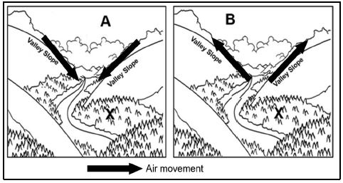
1.2.1 The wind at (A/B) blows during the day.
1.2.2 Wind (A/B) is a katabatic wind.
1.2.3 A high pressure develops on the valley floor during the development of wind (A/B).
1.2.4 Frost resistant crops at X were planted due to the influence of wind (A/B).
1.2.5 Wind (A/B) is associated with temperature inversions. (5 x 1) (5)
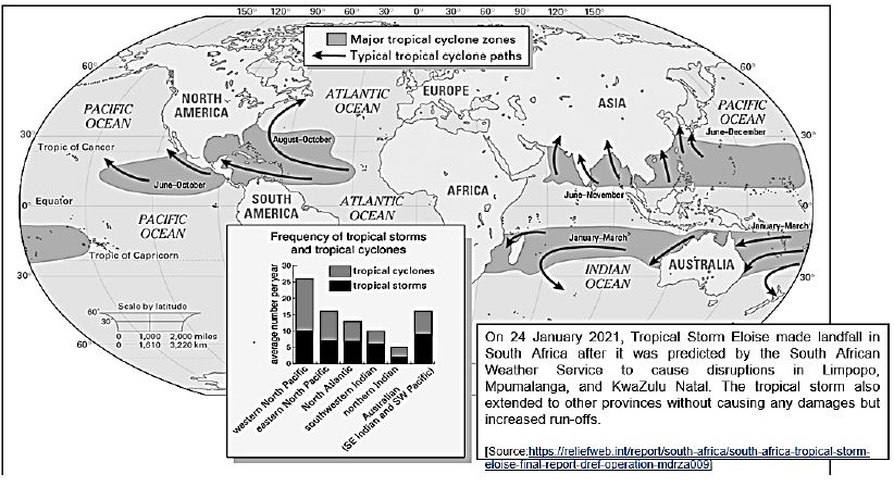
1.3 Refer to the infographic (FIGURE 1.3) on major tropical cyclone zones.
1.3.1How many tropical cyclones developed in the western North Pacific Ocean? (1 x 1) (1)
1.3.2 Give TWO reasons for the path/movement of tropical cyclones in the southern hemisphere. (2 x 1) (2)
1.3.3 State evidence from the map that links the occurrence of Eloise around Southern Africa. (1 x 2) (2)
1.3.4 Why was Eloise regarded as a tropical storm and not a tropical cyclone when it made landfall in South Africa? (1 x 2) (2)
1.3.5 Explain the importance of Coriolis force in the development of tropical cyclones. (2 x 2) (4)
1.3.6 Comment on the negative impact of the increased rainfall of Eloise on the infrastructure of certain provinces in South Africa. (2 x 2) (4)
FIGURE 1.3
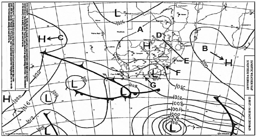
1.4 FIGURE 1.4 is a typical South African winter synoptic weather map.
1.4.1 Determine the isobaric pressure of isobar A. (1 x 1) (1)
1.4.2 Account for the position of anticyclones B and C in the season represented by the synoptic weather map. (1 x 2) (2)
1.4.3 The position of the Kalahari High causes very little chance of rainfall during winter. Draw a labelled cross profile from D to E to illustrate the reasons for this lack of clouds and rainfall in winter. (4 x 1) (4)
1.4.4 In a paragraph of approximately EIGHT lines, explain the differences in humidity/moisture levels experienced at weather stations F and G. (4 x 2) (8)
[40]
FIGURE 1.4
QUESTION 2: GEOMORPHOLOGY
2.1 Indicate whether each of the statements in COLUMN A applies to X ONLY or Y ONLY of the terms/concepts in COLUMN B. Write X ONLY or Y ONLY next to the question numbers (2.1.1 to 2.1.5) in the ANSWER BOOK, for example 2.1.6 X.
| COLUMN A | COLUMN B |
| 2.1.1 Ground water that feeds a river 2.1.2 Hard rock that does not allow water to pass through 2.1.3 The point where two tributaries meet 2.1.4 The area where rainfall accumulates near a river 2.1.5 The highest level of ground water | X Runoff X Porous |
(5 x 1) (5)
2.2 The FIGURE below illustrates river systems before and after river capture. Choose the correct term/concept between brackets to make the statements TRUE. Write only the term/concept next to the question numbers
(2.2.1 to 2.2.5) in your ANSWER BOOK, for example 2.2.6 river capture.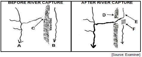
2.2.1 (River A/River B) flows over softer rock.
2.2.2 A knickpoint will develop at C because of (vertical/headward) erosion.
2.2.3 The high lying area at D, is called the (interfluve/watershed).
2.2.4 Stream E is known as a (misfit/captured) stream.
2.2.5 (Paired terraces/wind gap) might develop at F. (5 x 1) (5)
2.3 Refer to the diagram of a drainage pattern.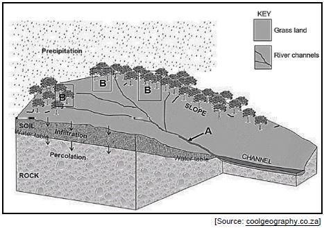
2.3.1 Identify the drainage pattern evident in the sketch. (1 x 1) (1)
2.3.2 State TWO characteristics of the underlying rock structure of the drainage pattern named in QUESTION 2.3.1. (2 x 1) (2)
2.3.3Determine the stream order at A. (1 x 2) (2)
2.3.4 Describe the relationship between stream order and the volume of water. (1 x 2) (2)
2.3.5 Housing development is planned in the demarcated area labelled B. In a paragraph of approximately EIGHT lines, explain the influence of this development on the stream order, as well as the water table. (4 x 2) (8)
2.4 The FIGURE shows an ungraded longitudinal profile of a river.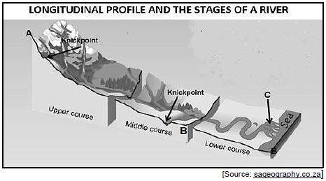
2.4.1 Name the stream flow that will dominate the upper course. (1 x 1) (1)
2.4.2 Describe the difference in the shape of the river channels in the upper and the middle course. (2 x 1) (2)
2.4.3 Refer to the slope from A to B of the ungraded longitudinal profile:
- What is a knickpoint? (1 x 2) (2)
- Why is there an absence (non-appearance) of knickpoints in the lower course of the river? (1 x 2) (2)
- How will the knickpoints (in the sketch) be removed to cause the longitudinal profile to eventually become graded? (1 x 2) (2)
2.4.4 Explain how the gentle gradient in the lower course and the sea promotes the development of the delta at C. (3 x 2) (6)
[40]
QUESTION 3: RURAL AND URBAN SETTLEMENTS
3.1 The photographs below classify different rural settlements. Match the descriptions in QUESTIONS 3.1.1 to 3.1.5 with photographs A, B or C in the ANSWER BOOK, for example 3.1.6 A.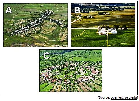
3.1.1 Settlement that reduces the distance to be travelled to the centre.
3.1.2 Developed due to extensive farming.
3.1.3 Settlement that developed along a road/river.
3.1.4 Settlement that has the most social disadvantages.
3.1.5 Fragmentation of the farming land hinders intensive commercial farming. (5 x 1) (5)
3.2 The following questions refer to the characteristics of street patterns. Various options are provided as possible answers to the questions. Choose the correct answer and write only the letter (A–D) next to the question numbers
(3.2.1 to 3.2.5) in the ANSWER BOOK, for example 3.2.6 D.
3.2.1 The … street pattern consists of roads moving from a central point.
- grid
- irregular
- radial
- rectangular
3.2.2 The street pattern where fewer intersections than the other street (patterns) can be found, is the … street pattern.
- rectangular
- grid
- irregular
- radial
3.2.3 The street pattern that is the costliest to build:
- Radial
- Rectangular
- Grid
- Irregular
3.2.4 Advantages of the irregular street pattern are:
- Easy to plan
- Accommodates topography
- Improves traffic flow
- Subdividing of plots is easier
Choose the correct combination:- (i) and (ii)
- (ii) and (iii)
- (iii) and (iv)
- (i) and (iv)
3.2.5 Disadvantages of the grid street pattern are:
- There is a lot of wasted space
- Very difficult to layout
- It increases the chances of accidents happening
- Monotonous and old
Choose the correct combination:- (i) and (ii)
- (ii) and (iii)
- (iii) and (iv)
- (i) and (iv) (5 x 1) (5)
3.3 Refer to the hierarchy of urban settlements in the sketch.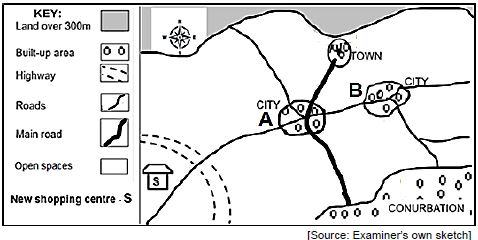
3.3.1 Define the concept urban hierarchy. (1 x 2) (2)
3.3.2 What will hinder (prevent) the town from expanding in a northerly direction? (1 x 1) (1)
3.3.3 Will more specialised goods be found at city A, rather than city B? (1 x 1) (1)
3.3.4 Explain your answer to QUESTION 3.3.3. (1 x 2) (2)
3.3.5 Refer to the shopping centre.
- Is the new shopping centre a regional or neighbourhood shopping centre? (1 x 1) (1)
- Comment on the suitability of the location for the shopping centre (answer to QUESTION 3.3.5 (a)). (2 x 2) (4)
- Explain the impact of this shopping centre (answer to
QUESTION 3.3.5
- on the threshold population of CITY A. (2 x 2) (4)
3.4 Refer to the infographic based on urban decay.
President Cyril Ramaphosa recently added his voice to calls to address the severe decay of historical inner cities in most of the country’s major cities and towns. Inner-city renewal was important, he indicated, as part of the economic recovery process, especially since the Covid-19 lockdown had compounded the country’s economic crisis. |
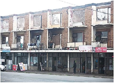
3.4.1 What is urban decay? (1 x 2) (2)
3.4.2 According to president Ramaphosa, what has compounded the country’s economic crisis? (1 x 1) (1)
3.4.3 State TWO pieces of evidence from the photograph that indicates that urban decay has taken place. (1 x 2) (2)
3.4.4 How can inner-city renewal help with economic recovery in South Africa? (1 x 2) (2)
3.4.5 In a paragraph of approximately EIGHT lines, explain the major causes of urban decay in South African cities. (4 x 2) (8)
[40]
QUESTION 4: GEOGRAPHICAL SKILLS AND TECHNIQUES
BACKGROUND INFORMATION ON AUGRABIES
Co-ordinates: 28°35'S; 20°20'E [Source: https://en.wikipedia.org/wiki/Augrabies,_Northern_Cape] |
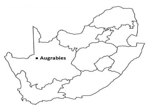
The following English terms and their Afrikaans translations are shown on the topographic and orthophoto maps:
| ENGLISH | AFRIKAANS |
| Holiday resort Island National park Mission station | Vakansie-oord Eiland Nasionale park Sendingstasie |
4.1 MAP SKILLS AND CALCULATIONS
Various options are provided as possible answers to the following questions. Choose the correct answer and write only the letter (A–D) next to the question numbers (4.1.1 to 4.1.3) in the ANSWER BOOK, for example 4.1.6 A.
4.1.1 The feature found at grid location 28°36'13''S; 20°20'27''E is/a …
- spot height.
- orchards and vineyards.
- row of trees.
- ruin.
(1 x 1) (1)
4.1.2 Augrabies is situated:
- In the Western Cape Province
- In the Northern Cape Province
- Upstream of Upington
- Downstream of Upington
Choose the correct combination:- (i) and (ii)
- (ii) and (iii)
- (ii) and (iv)
- (i) and (iii)
(1 x 1) (1)
4.1.3 Choose the likely rough cross-section from 6 to 7 on the orthophoto map. 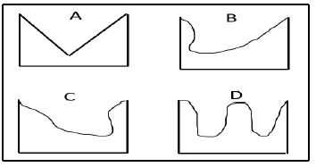
(1 x 1) (1)
4.1.4 Determine the magnetic bearing from trigonometrical station 74 (block E4) to spot height 652 (block C5) in 2022. Show ALL calculations. Marks will be awarded for calculations.
Formula: Magnetic bearing = True bearing + Magnetic declination
(3 x 1) (3)
4.1.5 The vertical interval is 4 m of the gradient of line 8 on the orthophoto map.
- What is the horizontal equivalent (HE) of line 8? (2 x 1) (2)
- Calculate the average gradient of line 8, by using the information in QUESTION 4.3.1(a).
Formula: Average Gradient =Vertical Interval (VI)Horizontal Equivalent (HE)
(2 x 1) (2)
4.2 MAP INTERPRETATION
4.2.1 The general wind direction in the area covered by block B4 in the topographic map is …
- south-west.
- south-east.
- north-west.
- north-east.
(1 x 1) (1)
4.2.2 The islands indicated by G on the topographic map, was caused by … and …
- silting
- braiding
- erosion
- weathering
Choose the correct combination:- (i) and (ii)
- (i) and (iii)
- (iii) and (iv)
- (i) and (iii)
(1 x 1) (1)
4.2.3 The type of settlement according to size and complexity at F in block E1 on the topographic map, is/a …
- hamlet.
- town.
- dispersed.
- nucleated.
(1 x 1) (1)
4.2.4 Refer to the fluvial landform found between blocks B1 and C3 on the orthophoto map.
- Identify this fluvial landform. (1 x 1) (1)
- Describe the slopes of this landform (answer to
QUESTION 4.2.4(a) by referring to the evidence on the orthophoto map. (1 x 2) (2) - Will the Augrabies Waterfall at 9, retreat in a south easterly or north westerly direction? Give a reason for your choice. (1 + 1) (2)
4.2.5 Refer to the settlement at H on the topographic map.
- Identify the pattern of the settlement at H. (1 x 1) (1)
- What is the shape of this settlement at H? (1 x 1) (1)
- Explain ONE factor that influenced the pattern of this settlement at H. (1 x 2) (2)
4.3 GEOGRAPHICAL INFORMATION SYSTEMS (GIS)
4.3.1 The data layers found in block A4 on the orthophoto map is:
- Drainage
- Infrastructure
- Relief/Topography
- Transport
Choose the correct combination:- (i) and (ii)
- (ii) and (iii)
- (iii) and (iv)
- (i) and (iii)
(1 x 1) (1)
4.3.2 Refer to the diagram shown below, which illustrates a GIS process.
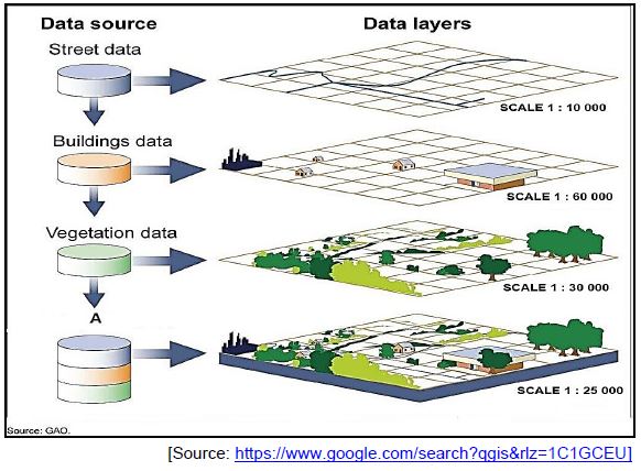
- Name the GIS process illustrated at A. (1 x 1) (1)
- Explain the GIS process you named in QUESTION 4.3.2(a). (1 x 2) (2)
4.3.3 Name the polygon phenomenon in block E2 on the topographic map. (1 x 1) (1)
4.3.4 Is the polygon phenomenon named in QUESTION 4.3.3, raster or vector data? (1 x 1) (1)
4.3.5 Comment on the importance of the polygon phenomenon (mentioned in QUESTION 4.3.3) for the residents of the Brabeesmond Settlement. (1 x 2) (2)
[30]
TOTAL: 150