MARINE SCIENCES PAPER 1 GRADE 12 MEMORANDUM - NSC PAST PAPERS AND MEMOS NOVEMBER 2021
Share via Whatsapp Join our WhatsApp Group Join our Telegram GroupPRINCIPLES RELATED TO MARKING MARINE SCIENCES
- If more information is given than marks allocated
Stop marking when the maximum number of marks is reached and draw a wavy line and write 'max' in the right-hand margin. - If, for example, three reasons are required and five are given
Mark the first three reasons irrespective of whether these first three are correct or not. - If a whole process is given when only a part of the process is required
Read the whole process given and credit the relevant part. - If comparisons are asked for, but descriptions are given
Accept the description if the differences or similarities are clearly stated. - If diagrams are given with annotations when descriptions are required
Mark the description. - If flow charts are given instead of descriptions
Mark the description only. - If a described sequence is muddled and links do not make sense
Where sequence and links are correct marks are given. Should a logical sequence resume, marks are given. - Non-recognised abbreviations
Accept the abbreviation if it is first defined in the answer. If the definition is not defined, do not give credit for the unrecognised abbreviation, but credit the rest of the answer if correct. - Wrong numbering
If the answer fits into the correct sequence of questions, but the wrong number is given, credit the answer if the answer is in the correct order. - If the language that is used changes the intended meaning
Do not accept the answer. - Spelling errors
If a word is recognisable (if read out loud), accept the answer, provided it does not mean something else in Marine Sciences terminology or if it is out of context. - In SECTION A if only the letter is asked for, but the correct option is given (and vice versa)
Give credit to the answer. - Be sensitive to the sense of an answer, which may be stated in a different way.
- Title
All illustrations (e.g. diagrams, graphs and tables) must have a title written above or below. - Code-switching of official languages (terms and concepts)
A term or concept written in any official language other than the learner's assessment language used in their answers should be credited, if it is correct. A marker that is proficient in Marine Science content and the official language used should be consulted. This is applicable to all official languages. - Changes to the marking guidelines
No changes must be made to the marking guidelines. The provincial internal moderator must be consulted, who in turn will consult with the national internal moderator (and the Umalusi moderators where necessary). - Official marking guidelines
Only marking guidelines bearing the signatures of the national internal moderator and the Umalusi moderators and distributed by the National Department of Basic Education via the provinces must be used.
MARKING GUIDELINES
SECTION A
QUESTION 1
1.1
1.1.1 A
1.1.2 B
1.1.3 B
1.1.4 A
1.1.5 C
1.1.6 D
1.1.7 C
1.1.8 A
1.1.9 B
1.1.10 A (10 x 2) (20)
1.2
1.2.1 Argenvillei zone
1.2.2 Calcifiers
1.2.3 Swash
1.2.4 Aragonite
1.2.5 Mariculture
1.2.6 Meiofauna
1.2.7 Generator (7 x 1) (7)
1.3
1.3.1 B only
1.3.2 Both A and B
1.3.3 A only
1.3.4 Both A and B (4 x 2) (8)
1.4
1.4.1 A - wavelength B – amplitude (2)
1.4.2 crest (1)
1.4.3 A wavelength (2)
(5)
TOTAL SECTION A: 40
SECTION B QUESTION 2
2.1
2.1.1 Average percentage change in mass (1)
2.1.2
- The longer the exposure time, the greater the average percentage change in mass (for both species)
(need both variables and relationship)
OR
- The shorter the exposure time, the lower the average percentage change in mass (for both species).
(need both variables and relationship)
OR
- Species B is better suited to deal with dessication than Species B. (Species A and B are interchangeable, as it’s a hypothesis.) (2)
2.1.3 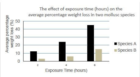
(9)
MARKING GUIDELINES | |
CRITERIA | MARK ALLOCATED |
Title (C) | 1 |
Type of graph (T) | 1 |
Label for X-axis (XL) | 1 |
Label for Y-axis (YL) | 1 |
Unit of measurement for X-axis (XM) | 1 |
Unit of measurement for Y-axis (YM) | 1 |
Key (label for bars) – (K) | 1 |
Plotting (P): | |
0 bars correct 1-3 bars correct 4-6 bars correct | 0 1 2 |
TOTAL MARKS | 9 |
2.1.4
- (Species) B (1)
- (Species) A (1)
2.1.5
- The middle eulittoral zone is more exposed
- Than the lower eulittoral zone
- As species B experienced the lowest average percentage change in mass
- It shows that species B is best suited/adapted to the middle eulittoral zone (4)
(18)
2.2
2.2.1 Indian Ocean Basin
2.2.2 Cool Temperate Region
2.2.3
- The movement of ocean water
- As the result of a balance between the Coriolis effect and
- The surface wind drag/ from the wind blowing over the Surface/ fetch of the wind
2.2.4
- The surface water is dragged
- By the prevailing south-east wind
Owing to Ekman transport it moves westward/offshore to the left - Because the surface water is being pushed offshore
- It must be replaced from below
- This results in an upward-moving current (Any 4
2.2.5
- Cool Temperate Region: regular increases in nutrients (due to upwelling)/high nutrient levels
- Results in larger population sizes
- Subtropical Region: low nutrients
- Smaller population sizes
(13)
2.3
2.3.1 Biomimicry
2.3.2
- Cause: need to stand up to strong forces
- examples: forceful storms / large waves / strong currents
- (more than 2 examples)
- effect: all of which could damage the devices/ refer to stability of the device
- give credit for biomimicry principle (such as emulating the kelp holdfasts and holdfast firmly anchoring kelp) ( max 3)
2.3.3
- Corrosion
- Biofouling
- Cost
- Fluctuating wave and current strength (Mark first 2 only)
2.3.4
- Carrageenan
- Agar
- Algin/Alginate/Alginic acid
- Beta-carotene (Mark first 3 only) (1)
QUESTION 3
3.1
3.1.1
- Beaches with higher energy (stronger waves and currents)
- short with steep gradient (bullets 1 and 2 linked)
- Beaches with lower energy (calmer conditions)
- beaches with shallow gradient (bullets 3 and 4 linked) (4)
3.1.2
- Plough snails emerge/come up from burrows when the tides rises
- Strong sense of smell guides them to food
- They “surf” to the high tide mark to eat
- Once they have eaten, retreat as the tide recedes
- Burrow into the mid-tide sand (Any 4)
3.2
3.2.1 Corrosion is the chemical action (of sea water) on rocks
3.2.2 H2CO3
3.2.3 CO2 combines with water (to form carbonic acid) (1)
3.2.4
- This will lead to increased amounts of carbonic acid in the ocean / ocean acidification/ lower pH
- This will lead to increased corrosion
3.3
3.3.1 Category 1 (1)
3.3.2
- It should be available for research
- It should include representative samples of ecosystems and/or the geology of the region
- It can include specific species to be studied (Any 2)
3.4
3.4.1 Thermohaline circulation
3.4.2 Cold
3.4.3
- Less/no ice forming
- Less salt into water
- Less water sinking
- Less water displacement/overturning
- Disruption of the circulation pattern/ slowing down of the thermohaline circulation(Any 3 marks, reasoning) (3)
3.4.4
- The temperature difference between the warm, surface water and the colder, deeper water
- leads to a density difference
- Can be used to turn a turbine/kinetic energy/causes movement
- Which generates electricity (3)
3.4.5
- At the Equator
- Greatest difference
- Between the warm, surface waters and the cold, deeper waters (3)
(11)
3.5
3.5.1 It may increase (in frequency from about one every 20 years to one every 10 years)
3.5.2 The frequency of droughts in the Amazon would increase/become drier
3.5.3
- The warm, surface water off the coast
- Will kill the organisms
- In the normal cold water food chains
- Decomposing organisms increase hydrogen sulphide levels
OR
- Less upwelling
- Results in less nutrients
- Animals die off
- Decomposing organisms increase hydrogen sulphide levels
(Any 3) (3)
3.5.4
- Wetter conditions for Indonesia, Australia and parts of the Amazon
- Dry conditions in the southern tier of United States
- Wet/cold conditions for South eastern coast of Africa
- Drier than normal conditions over the coastal regions of Peru and Chile
- Flooding increases in India, Burma and Thailand
- Disruption of the Monsoon in Asia
- Diversion of major storms
- Abnormal atmospheric waves in the upper atmosphere Jet Stream
- Potential for drought in central Europe and USA
- Increase in air pressure over Easter Island
- Decrease in air pressure in Indonesia
(note: NOT increased trade winds, part of the process)
(Mark first 3 only) (3)
3.5.5
- The increase in the frequency of major rainfall events
- With the influx of fresh water
- cause decreased salinityof the rock pools,
- With lower temperatures
- The organisms would have to deal with greater fluctuations in temperature (5)
(13)
[40]
TOTAL SECTION B: 80
SECTION C
When marking essays, be aware of maximum marks per subsection (indicate with the designated letter to keep track) and compulsory marks per section (indicate with C). The breakdown of the synthesis marks is indicated for each question. Credit valid points content points which may come from external reading, but keep to maximum allocations per subsection.
ASSESSING THE PRESENTATION OF THE ESSAY
USE OF PARAGRAPHS (PAR) | INTRODUCTORY PARAGRAPH (INTR) | RELEVANCE | LOGICAL SEQUENCE | CONCLUDING PARAGRAPH |
Separating the information into logical subsets. | Original and logical statement of intent. Not a repetition of the question. | All information provided is relevant to the question. | Ideas arranged in a logical/ cause-effect sequence. | Logical and succinct summing up of the body. Not a repetition of the question. |
QUESTION 4
Biosphere Reserve (B)
- An area made up of (terrestrial), marine and coastal ecosystems
- That promotes the conservation of nature
- While allowing multiple human use of the ecosystems in the reserve
- In a sustainable way
- Some areas have greater protection than other areas Max
Fisheries stock determination (F)
- Over a period of time fishers have caught fish species
- Keep constant variables the same/ by the same fisher, in the same area, under the same seasonal conditions, for the same time period and with the same equipment
- If the catch remains the same, the population is stable
- If during the same controlled conditions fewer fish are caught, the population decreases
- Can also use the record books of the fishers to get an idea of previous catches
- Determine size frequency of the fish in the samples
- Calculate the growth rate of the measured species
- Tag fish and see how many of the marked fish are caught again/Tag and release study to determine population size
- Calculate the abundance of fish in the area
- Measure and analyse the age/ sex/ number of eggs per female
- Measure the mass/length of the sample fish
Estuary ecological importance (E)
- Adult fish enter the estuaries to spawn
- Juvenile fish move into estuaries after hatching
- Pelagic game fish move into the estuary to hunt
- Estuary serves as a “safe space” for growing fish
- Fish use estuaries as nurseries
- Good habitat for water birds that forage for food
- Some permanent residents
- Important stopover for migratory species
- for seasonal migratory species Max
TIES (T)
- Minimise negative impacts to the tourist destination and the communities who live in the area
- Build awareness and respect among tour operators, local communities and the tourists
- Provide positive experiences for both visitors and the hosts
- Provide direct financial benefits for conservation
- Generate financial benefits for the local people as well as private industry
- Deliver memorable interpretative experiences to visitor, raising sensitivity
(Any 3, Max 3
COMMUNITY OPINION
POSITIVE (P) Open ended (use the following as guidelines)
- Realise the importance of conserving the beauty of the area, in particular the lagoon
- See potential for tourism infrastructure such as restaurants/ accommodation/ transport/ health services
- Employment opportunities
- Conserving the area for future generations
- Any relevant positive motivation Max
NEGATIVE (N) Open ended
- Core area of Biosphere reserve would be protected, meaning a section (of area where used to fish) not available for fishing
- Fishers not seeing/not aware/educated about the potential benefits of closing core area of Biosphere reserve (such as replenishment of fish stock and more recruitment of fish)
- Community is concerned about tourism impacts such as litter
- Community is concerned that their “sense of community” and atmosphere of small coastal town will be changed by influx of tourists
- Any relevant negative opinions/concerns
[30]
QUESTION 5
Category 3 Marine Protected Area (C)
- It is an area of high cultural/historical significance
- It is a sensitive area (because of breeding sites of bird species)
- Endemic species
- Therefore, important from ecological point of view
- Focus should also be on protection of the ecosystems
- Relevant reasoning Max
Prevent overfishing (F)
- Legislation
- Monitoring
- Education
- Replenishment Areas/No-take zones
- Stocks can recover and spill over into surrounding areas
- Through accurate and reliable research
- Only take species that are consumed/avoid bycatch of other species
- Minimise the effects on other non-targeted species
- Change equipment/fishing gear
- To avoid habitat destruction/ecosystem disruption
- Adhere to fishing legislations/fishing quotas/TACs/Permit conditions (max 3 marks can be given here)
- Increase the number of mariculture facilities
- Provide job opportunities to staff that were previously employed by the fisheries
- Increase education/awareness efforts
- Additional logic statements from the student can be accepted.
Nature-based tourism vs ecotourism (E)
- Both centred on wild or natural environments
- But nature-based tourism offers little consideration to the environmental impact
- Nature-based can be “greenwashing”
- Such as carbon footprint/waste/energy use policies
- Ecotourism is the responsible travel to natural areas
- Minimise negative effects to the environment
- That sustains the well-being of the local people
- Involves interpretation and education/awareness of guests and staff Max
Kelp forests (K)
- Kelp holdfasts provide a haven for a high diversity of small invertebrates/ filter feeders
Safe breeding grounds/nursery
- Kelps also reduce the effect of wave action
- Providing calm/sheltered inshore environments in which animals can thrive
- Kelp particles, decomposition bacteria and phytoplankton blooms are capitalised on by herbivores
- Slime from damaged fronds creates nutrient-rich foam
- Few herbivores graze on living kelp
- The kelp limpet aggressively defends kelp from other herbivores from being overgrazed
- exception of the kelp limpet that defends the kelp from being overgrazed
- Carnivores and omnivores, in turn, feed on the filter-feeders and each other
Opinion (O)
Open Ended: do not give marks for Enough/Not Enough – provide marks for reasoning 1 mark per reason
Enough – learner considers what is being done to conserve the coastal ecosystems
- New Marine Protected Areas proclaimed
- Rescue actions of birds affected
- More environmental awareness
Any relevant TWO reasons
Not enough is being done (learner considers negative impacts of human activities on the coastal ecosystems.
- Overfishing of stocks continues
- Resulting in birds not having enough food
- Plastic pollution cause death of marine organisms
- Oil spills, seabird feathers not waterproof when covered with oil
Any relevant TWO reasons
TOTAL SECTION C: 30
GRAND TOTAL: 150