GEOGRAPHY PAPER 1 GRADE 12 QUESTIONS - NSC PAST PAPERS AND MEMOS NOVEMBER 2021
Share via Whatsapp Join our WhatsApp Group Join our Telegram GroupINSTRUCTIONS AND INFORMATION
- This question paper consists of TWO SECTIONS:
SECTION A:
QUESTION 1: Climate and Weather (60)
QUESTION 2: Geomorphology (60)
SECTION B:
QUESTION 3: Geographical Skills and Techniques (30) - Answer all THREE questions.
- ALL diagrams are included in the QUESTION PAPER.
- Leave a line between the subsections of questions answered.
- Start EACH question at the top of a NEW page.
- Number the answers correctly according to the numbering system used in this question paper.
- Do NOT write in the margins of the ANSWER BOOK.
- Draw fully labelled diagrams when instructed to do so.
- Answer in FULL SENTENCES, except when you have to state, name, identify or list.
- Units of measurement MUST be indicated in your final answer, e.g. 1 020 hPa, 14 °C and 45 m.
- You may use a non-programmable calculator.
- You may use a magnifying glass.
- Write neatly and legibly.
SPECIFIC INSTRUCTIONS AND INFORMATION FOR SECTION B - A 1 : 50 000 topographic map 2331CC PHALABORWA and a 1 : 10 000 orthophoto map 2331 CC 18 PHALABORWA (NORTH) are provided.
- The area demarcated in RED/BLACK on the topographic map represents the area covered by the orthophoto map.
- Show ALL calculations. Marks will be allocated for this.
- You must hand in the topographic and the orthophoto map to the invigilator at the end of this examination session.
QUESTIONS
SECTION A: CLIMATE AND WEATHER AND GEOMORPHOLOGY
QUESTION 1: CLIMATE AND WEATHER
1.1 Various options are provided as possible answers to the following questions. Choose the answer and write only the letter (A–D) next to the question numbers (1.1.1 to 1.1.8) in the ANSWER BOOK, e.g. 1.1.9 D.
1.1.1 A mid-latitude cyclone occurs between … north and south of the equator.
- 5° and 25°
- 30° and 60°
- 0° and 5°
- 60° and 90°
1.1.2 A mid-latitude cyclone is steered (driven) by the …
- easterlies.
- polar easterlies.
- trade winds.
- westerlies.
1.1.3 The change in wind direction of the mid-latitude cyclone in the Southern Hemisphere is called …
- veering.
- backing.
- rotating.
- converging.
1.1.4 The front below is a … front.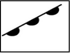
- cold
- occluded
- warm
- stationary
1.1.5 The mid-latitude cyclone below is in the … stage.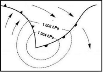
[Source: https://www.google.com/search?q=mid-latitude]
- initial
- wave
- mature
- occluded
1.1.6 The conditions experienced behind a cold front are a/an …
- increase in pressure and decrease in temperature.
- decrease in pressure and decrease in temperature.
- increase in pressure and increase in temperature.
- decrease in pressure and increase in temperature.
1.1.7 Which symbol below illustrates the merging of a cold and warm front?
1.1.8 The station model generally associated with a cold front in the Southern Hemisphere: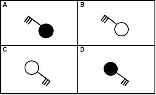
(8 x 1) (8)
1.2 Choose the correct word(s) from those given in brackets. Write only the word(s) next to the question numbers (1.2.1 to 1.2.7) in the ANSWER BOOK.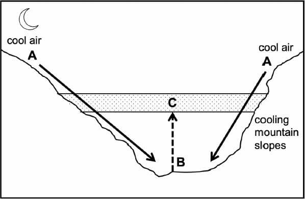
[Source: Examiner's own sketch]
1.2.1 Air at A cools because of (solar/terrestrial) radiation.
1.2.2 Downward movement of air along the valley slopes occurs during the (night/day).
1.2.3 Air movement from A to B results in a/an (anabatic/katabatic) wind.
1.2.4 Dew point temperature drops to below freezing point at (A/B) at night.
1.2.5 Precipitation that forms at B when the dew point temperature drops below 0 °C is (frost/radiation fog).
1.2.6 Displaced air from the valley results in a/an (inversion layer/thermal belt) developing at C.
1.2.7 Layer C is more developed during the (day/night). (7 x 1) (7)
1.3 Refer to the infographic on Tropical Cyclone Eloise.
DESCRIPTION OF THE DISASTER Tropical Cyclone Eloise made landfall on 23 January 2021, 20 km south of Beira in Mozambique, as a category 2 tropical cyclone. Wind speeds of up to 160 km/h were recorded. Tropical Cyclone Eloise also caused heavy rainfall with 250 mm of rain in 24 hours. Other areas were already flooded ahead of Eloise's landfall, resulting in thousands of displaced people. | ELOISE IN NUMBERS
| ||||||||||||||||||
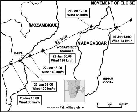 | |||||||||||||||||||
1.3.1 Give ONE piece of evidence in the infographic that the tropical cyclone is in the Southern Hemisphere. (1 x 1) (1)
1.3.2 State TWO weather conditions associated with tropical cyclones indicated in the infographic. (2 x 1) (2)
1.3.3 Give ONE reason for the decrease in wind speed from 19 January to 20 January 2021. (1 x 2) (2)
1.3.4 Account for the increase in wind speed of Tropical Cyclone Eloise from the 20 January to 22 January 2021. (2 x 2) (4)
1.3.5 According to the infographic the negative impact of Tropical Cyclone Eloise was devastating. Suggest THREE strategies that could be put in place to reduce this impact. (3 x 2) (6)
1.4 Refer to the South African synoptic weather map.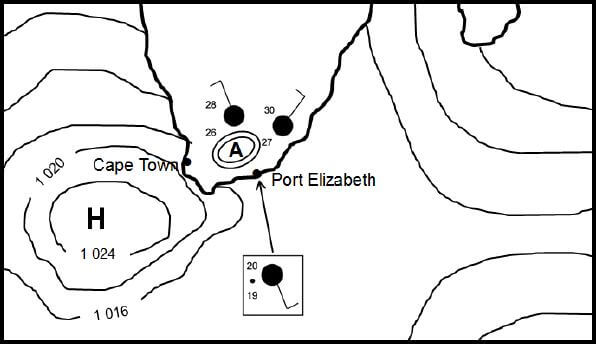
[Source: Examiner's own sketch]
1.4.1 Identify low-pressure system A on the synoptic weather map. (1 x 1) (1)
1.4.2 Give a reason for the formation of this low-pressure system over the interior. (1 x 2) (2)
1.4.3 Give evidence from the synoptic weather map that the South Atlantic high is ridging. (1 x 2) (2)
1.4 4 Why does the ridging of the South Atlantic high result in onshore winds? (2 x 2) (4)
1.4.5 Describe the weather conditions at Port Elizabeth as a result of the onshore winds. (3 x 2) (6)
1.5 Refer to the infographic on the South African berg wind.
Record-breaking heatwave hits East London 18 March 2021 East London residents were subject to sweltering heat last Saturday after a record-breaking | 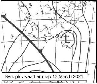 |
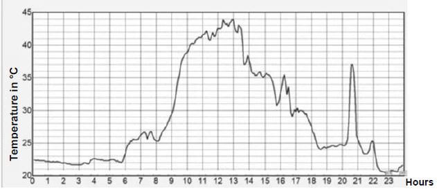 A graph tracking the temperature in East London over the course of Saturday 13 March A graph tracking the temperature in East London over the course of Saturday 13 MarchPicture: SA Weather Service | |
1.5.1 Name TWO pressure systems that are necessary for berg winds to develop. (2 x 1) (2)
1.5.2 Determine the highest temperature that was recorded on 13 March 2021. (1 x 1) (1)
1.5.3 What role did the escarpment play in increasing the temperature of the berg wind between 10:00 and 14:00? (2 x 2) (4)
1.5.4 In a paragraph of approximately EIGHT lines, explain the impact of berg wind conditions on the physical (natural) environment. (4 x 2) (8)
[60]
QUESTION 2: GEOMORPHOLOGY
2.1 Various options are provided as possible answers to the following questions. Choose the answer and write only the letter (A–D) next to the question numbers (2.1.1 to 2.1.8) in the ANSWER BOOK, e.g. 2.1.9 D.
Points X, Y and Z shows the different stages (courses) from the source to the mouth of a river and the points S-T along the meander found at Z.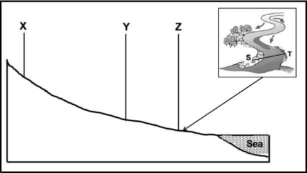
[Source: Examiner's own sketch]
2.1.1 The profile from the source to the mouth shows the … of the river.
- volume
- length
- width
- depth
2.1.2 The stages (courses) represented by X, Y and Z are …
- middle, upper, lower.
- lower, middle, upper.
- upper, middle, lower.
- upper, lower, middle.
2.1.3 … describes the river valley at X.
- Wide and shallow
- Wide and deep
- Narrow and shallow
- Narrow and deep
2.1.4 At Z the river has a laminar flow due to a … riverbed.
- rough and uneven
- steep and even
- gently sloping and even
- rocky (rock-filled)
2.1.5 Slope T on the meander is the ... slope.
- slip-off
- convex
- undercut
- gentle
2.1.6 Slope S on the meander is associated with a …
- steep gradient and deposition.
- gentle gradient and erosion.
- concave slope with erosion.
- convex slope with deposition.
2.1.7 The narrowing of the neck in the meander will eventually form a/an …
- braided stream.
- ox-bow lake.
- flood plain.
- river delta.
2.1.8 The meander will migrate … on the floodplain.
- upstream
- laterally
- downstream
- headwards (8 x 1) (8)
2.2 Refer to the sketch, which shows a waterfall with a plunge pool. Complete the statements in COLUMN A with the options in COLUMN B. Write only X or Y next to the question numbers (2.2.1 to 2.2.7) in the ANSWER BOOK, e.g. 2.2.8 Y.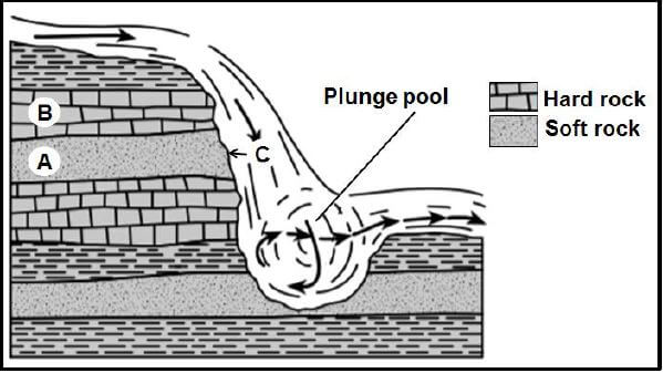
[Source: Examiner's own sketch]
| COLUMN A | COLUMN B |
| 2.2.1 Waterfalls form when … | X: there are alternate layers of hard and soft rock. Y: there are only soft rocks. |
| 2.2.2 Waterfalls are likely to be found in the … | X: lower course. Y: upper course. |
| 2.2.3 … refers to the softer rock that erodes faster. | X: Rock type A Y: Rock type B |
| 2.2.4 The plunge pool is formed by … | X: deposition. Y: erosion. |
| 2.2.5 When the softer rock at C erodes, it will cause ... | X: the rock at A to collapse into the plunge pool. Y: waterfalls to retreat downstream. |
| 2.2.6 The retreat of the waterfall will result in the formation of a … | X: gorge. Y: rapid. |
| 2.2.7 An advantage of a waterfall is … | X: hydro-electricity. Y: promoting water transport. |
2.3 Refer to the diagrams showing drainage patterns.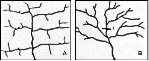
[Adapted from https://www.google.com/search?q=trellis+and+dendritic+drainage+patterns]
2.3.1 Identify drainage patterns A and B. (2 x 1)(2)
2.3.2 Differentiate between the underlying rock structure of drainage patterns A and B respectively. (2 x 2) (4)
2.3.3 Why are the tributaries of the main stream parallel to each other in drainage pattern A? (1 x 2) (2)
2.3.4 Determine the stream order at point 1 in drainage pattern B. (1 x 2) (2)
2.3.5 Choose the CORRECT word between brackets to make the statement TRUE. The higher the stream order, the (higher/lower) the drainage density.
(1 x 1) (1)
2.3.6 Refer to drainage pattern B and describe the relationship between;
- Drainage density and low rainfall (2)
- Drainage density and steep gradient (2)
2.4 Refer to the diagram of a flood plain.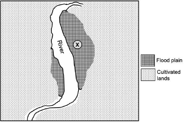
2.4.1 State the geomorphological process that gave rise to the formation of the flood plain. (1 x 1) (1)
2.4.2 Describe the gradient at X. (1 x 2) (2)
2.4.3 Suggest TWO reasons for the wide flood plain at X. (2 x 2) (4)
2.4.4 In a paragraph of approximately EIGHT lines, explain the physical (natural) impact of flooding on the flood plain. (4 x 2) (8)
2.5 Refer to the sketch map of rivers Y and Z before river capture has taken place.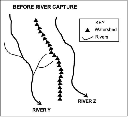
[Source: Examiner's own sketch]
2.5.1 Define the concept river capture. (1 x 2) (2)
2.5.2 State ONE condition needed for river capture to take place. (1 x 2) (2)
2.5.3 Draw a sketch to illustrate the area after river capture has taken place. Marks will be awarded for the accuracy of the sketch and indicating the following labels:
- Elbow of capture
- Misfit stream
- Wind gap (1 + 3) (4)
2.5.4 Will river Y or Z experience rejuvenation after river capture? (1 x 1) (1)
2.5.5 Give a reason for your answer to QUESTION 2.5.4. (1 x 2) (2)
2.5.6 Refer to your answer to QUESTION 2.5.5 and explain the impact of the change on the captor stream. (2 x 2) (4)
[60]
SECTION B
QUESTION 3: GEOGRAPHICAL SKILLS AND TECHNIQUES
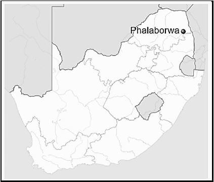
GENERAL INFORMATION ON PHALABORWA
Coordinates: 23°52' S ; 31°04' E [Adapted from https://en.wikipedia.org/wiki/Phalaborwa] |
The following English terms and their Afrikaans translations are shown on the topographic map:
ENGLISH AFRIKAANS
Diggings Uitgrawings
Golf course Gholfbaan
River Rivier
Sewerage works Rioolwerke
Estate Landgoed
Salt pan Soutpan
Nature reserve Natuurreservaat
3.1 MAP SKILLS AND CALCULATIONS
3.1.1 In which province is Phalaborwa? (1 x 1) (1)
3.1.2 31 in the map index 2331CC refers to …
- longitude.
- latitude.
- graticule.
- code. (1 x 1) (1)
3.1.3 What is the map index south-west of 2331CC?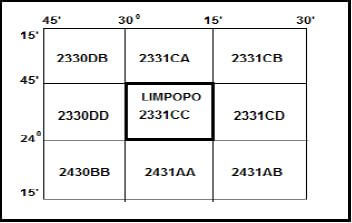
- 2331CD
- 2431AB
- 2430BB
- 2330DB (1 x 1) (1)
3.1.4 Calculate the area covered by feature 6 in blocks D4/5 and E4/5 on the orthophoto map in m².
Use the following information:
Measured length (map distance) = 2 cm
Formula: Area = Length (L) x Breadth (B) (4 x 1) (4)
3.1.5 Why does feature 6 appear larger on the orthophoto map than on the topographic map? (1 x 1) (1)
3.1.6 Determine the true bearing from spot height 445, I in block A4 to spot height 421, J in block C4 on the topographic map. (1 x 1) (1)
3.1.7 The magnetic declination for 2021 is 17°10' west of true north. Use the true bearing in your answer to QUESTION 3.1.6 to calculate the magnetic bearing.
Formula: MB = True bearing (TB) + Magnetic declination (MD) (1 x 1) (1)
3.2 MAP INTERPRETATION
Refer to the seasonal rainfall graph and the topographic map of Phalaborwa.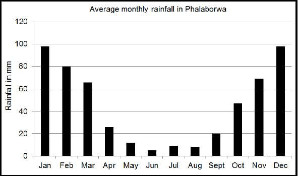
[Source: https://www.google.com/search?q=rainfall graph Phalaborwa]
3.2.1
- In which season is the lowest rainfall experienced in Phalaborwa? (1 x 1) (1)
- Identify the type of river that show that the mapped area receives seasonal rainfall. (1 x 1) (1)
- State ONE strategy in block A2 that has been implemented to overcome water shortages. (1 x 2) (2)
3.2.2 The wind direction in blocks B4 and C4 on the topographic map is either north-north-west or south-south-east. Give evidence from the blocks above to support this statement. (1 x 2) (2)
3.2.3 Landform 7 in block B1 on the orthophoto map is a …
- gap.
- pass.
- gorge.
- saddle. (1 x 1) (1)
3.2.4 The feature at F in block C5 on the topographic map is a/an …
- interfluve.
- confluence.
- watershed.
- catchment. (1 x 1) (1)
3.2.5 Match landform 8 in block C1 on the orthophoto map with the correct freehand cross-section. (1 x 1) (1)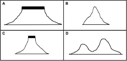
Refer to block A4 on the topographic map.
3.2.6 Give the general direction in which river G is flowing. (1 x 1) (1)
3.2.7 How do tributaries assist in identifying the direction in which river G flows? (1 x 2) (2)
3.3 GEOGRAPHICAL INFORMATION SYSTEMS (GIS)
Refer to the demarcated area in block A1 on the topographic map.
3.3.1 The non-perennial rivers in the demarcated area are an example of (raster/vector) data. (1 x 1) (1)
3.3.2 Which GIS concept describes the process of demarcation in block A1?
- Buffering
- Fencing
- Security
- Querying (1 x 1) (1)
.3.3 Give evidence to show how this process was implemented to demarcate the non-perennial rivers. (1 x 2) (2)
Refer to block B4 on the topographic map.
3.3.4 Identify TWO examples of data layers that were considered by GIS specialists before developing the landing strip in block B4. (2 x 1) (2)
3.3.5 Why was it important for GIS specialists to utilise the layers identified in QUESTION 3.3.4? (1 x 2) (2)
[30]
TOTAL: 150