GEOGRAPHY PAPER 1 GRADE 12 ANNEXURE - NSC EXAMS PAST PAPERS AND MEMOS MAY/JUNE 2021
Share via Whatsapp Join our WhatsApp Group Join our Telegram GroupGEOGRAPHY PAPER 1
GRADE 12
NATIONAL SENIOR CERTIFICATE EXAMINATIONS
ANNEXURE
MAY/JUNE2021
FIGURE 1.1: URBAN HEAT ISLAND EFFECT DURING THE DAY AND NIGHT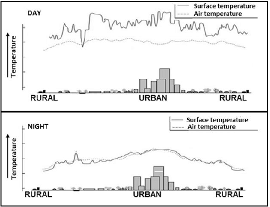
FIGURE 1.3: MID-LATITUDE CYCLONES
MID-LATITUDE CYCLONES OVER THE WESTERN CAPE
South Africa is among a handful of countries that experience winter rainfall in some areas and summer rainfall in others. The south-western tip of the country has a Mediterranean climate, with hot dry summers and cool wet winters. This is because mid-latitude cyclones migrate further north during winter, allowing the edge of the cold front arm to sweep across the southernmost part of the country. This results in frontal winter rainfall over the Western Cape. The movement of the cold front over the Western Cape is generally associated with a variety of weather changes. These cyclones can have a positive or negative impact on tourism.
FIGURE 1.4: SLOPE ASPECT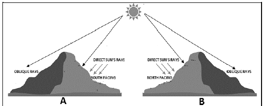
FIGURE 1.5: DRAINAGE DENSITY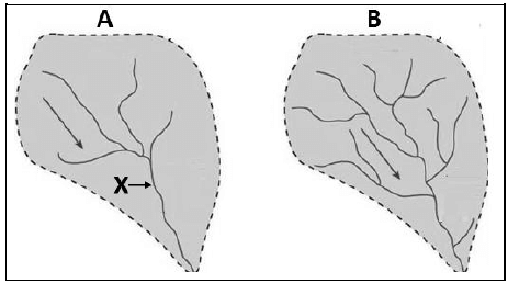
FIGURE 1.6: RIVER CAPTURE (STREAM PIRACY)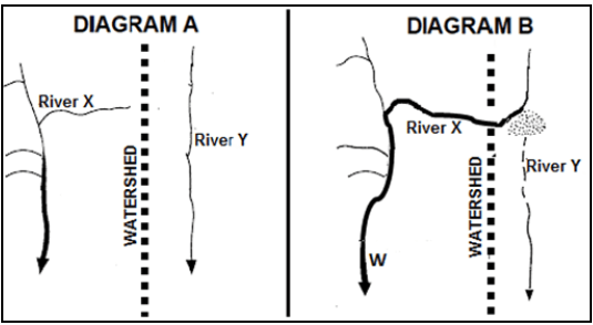
FIGURE 2.2: LAMINAR AND TURBULENT FLOW OF A RIVER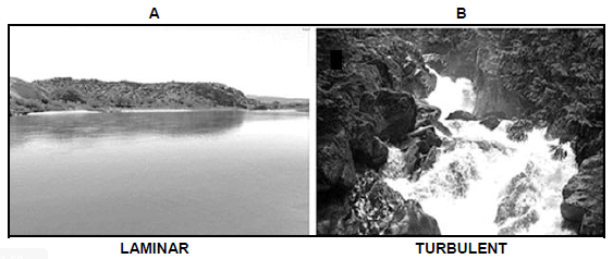
FIGURE 2.3: SYNOPTIC WEATHER MAP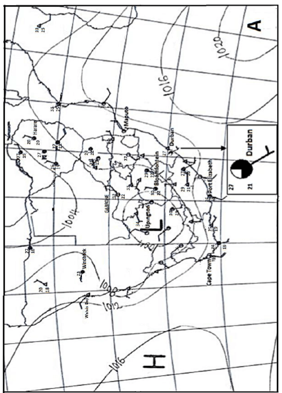
FIGURE 2.4: SOUTH AFRICAN BERG WINDS
BERG WINDS IN KWAZULU-NATAL
Blog one
Since Sunday we have experienced berg wind conditions here in KwaZulu-Natal. These winds are caused by a high-pressure system lying over the interior of South Africa and this forces the air over the escarpment and down the leeward side of the Drakensberg. Temperatures can rise to as high as thirty degrees Celsius in a few hours. These winds can have a speed varying from 10 km per hour to over 100 km per hour and it can be very destructive.
Blog two
On Sunday the wind was very strong, and the temperatures here in our district rose from the mid-teens last week to the high twenties yesterday and today. This time of the year is also known as the fire season in KZN. These hot, dry winds are very conducive to fires. A fire driven by a 100 km an hour berg wind is unstoppable. No farmer dare leave his farm during this time, as a fire could wipe out a lifetime of work.
FIGURE 2.5: DRAINAGE PATTERNS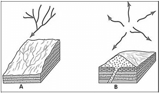
FIGURE 2.6: FLUVIAL LANDFORMS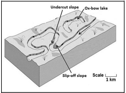
FIGURE 3.3: LAND REFORM LAND REFORM BREATHES NEW LIFE
Land reform has the potential to breathe new life into the economy, especially in rural areas, by reducing unemployment and giving previously disadvantaged farmers the opportunity to become commercial farmers. In addition, it has the capacity to reduce social unrest by reducing the historic and large gap between white and black land ownership. Despite talks about its importance since the 30% redistribution target was set in 1996, land reform has never been a political priority. Instead, it has been covered in controversy, with millions of rands being wasted on failed projects due to a variety of reasons. These reasons vary from government inefficiency to a shortage of skills and lack of business and financial support. Even the number of hectares that have been transferred is uncertain. Government last year argued that there was still a long way to go. It is estimated that a total of 17,4 million hectares had been transferred from white ownership since 1994. This is equal to 21% of the 82,8 million hectares farmed in South Africa.
FIGURE 3.4: URBANISATION
SOUTH AFRICAN URBANISATION DATA
(Population in thousands)
| POPULATION | 1950 | 2014 | 2050 |
| Urban | 5,778 (42,2%) | 34,167 (64,3%) | 49,102 (77,4%) |
| Rural | 7,905 (57,8%) | 18,972 (35,7%) | 14,304 (22,6%) |
| Total | 13,683 | 53,139 | 63,405 |
FIGURE 3.5 GOLD MINING IN SOUTH AFRICA
FACTS ON GOLD MINING
- The Witwatersrand Basin remains the world's largest gold resource.
- Gold profits increased by 3,7%, from R70 billion in 2018 to R72,6 billion in 2019.
- Gold production decreased from 117 tonnes in 2018 to 101,3 tonnes in 2019.
- Due to the current gold price, more than half of the South African gold mining industry is marginal (making minimal profits).
- South African gold only accounts for 4,2% of the global gold production.
- Employment in the gold sector has declined over the years.
- The gold industry currently employs 95 130 people compared to 100 189 people in 2018.
- Total employee earnings have soared from R15,9 billion in 2008 to R24,3 billion in 2019.
FIGURE 3.6: PLATINUM SPATIAL DEVELOPMENT INITIATIVE (SDI)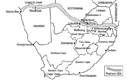
The Platinum Spatial Development Initiative (Platinum SDI) is located in North West, South Africa. It aims to develop all the areas on the N4 highway that links South Africa's most densely populated areas with Lobatse in Botswana. By developing nodes along the logistical corridor, the aim is to stimulate economic development. Rustenburg stands to benefit from increased traffic along this route, which is intended to link Namibia and Mozambique.
[Adapted from https://www.brandsouthafrica.com/investments- investing-in-north-west-province]
FIGURE 4.3: URBAN LAND-USE ZONES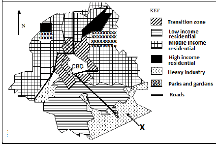
FIGURE 4.4: URBAN SETTLEMENT ISSUES: INFORMAL SETTLEMENTS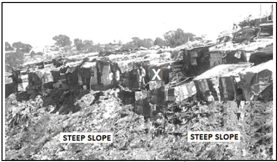
FIGURE 4.5: FOOD SECURITY
THE EXTENT OF FOOD SECURITY IN SOUTH AFRICA
While South Africa is food secure at national level, the country is still food insecure at household level as not all households have access to adequate food. Poverty-stricken households lack money to buy food and are unable to produce their own food. These households also have the inability to secure employment or to generate income. Poor households are also typically characterised by few people earning an income with many dependents, and they are particularly vulnerable to economic shocks. According to the report, more than half the households with young children that experienced hunger were in urban areas. The involvement of households in agricultural activities for subsistence farming can play an important role in reducing the vulnerability to hunger. The results show that out of 16,2 million households, about 2,5 million households (15,6%) were involved in agricultural activities in South Africa. Although the main source of income for rural households was social grants, most households involved in agricultural activities indicated that the main reason for their involvement is to supplement food for the household. [Economic shock: An unpredictable event that affects the economy negatively or positively]
FIGURE 4.6: PORT ELIZABETH-UITENHAGE (NELSON MANDELA METROPOLE) CORE INDUSTRIAL REGION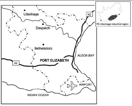
Port Elizabeth is the centre of the automobile industry in South Africa. Volkswagen and Ford have plants in the city. In addition, there are many auto component manufacturers in the city. Globalisation has forced these manufacturers to become world competitors and, in many cases, to play a role in the global strategy of their parent companies.
[Globalisation: connecting the economies of the world]