Geography Paper 2 Grade 12 Memorandum - NSC Past Papers And Memos September 2020 Preparatory Examinations
Share via Whatsapp Join our WhatsApp Group Join our Telegram GroupMEMORANDUM
QUESTION 1: MULTIPLE-CHOICE QUESTIONS
1.1 C
1.2 A
1.3 B
1.4 D
1.5 C
1.6 C
1.7 C
1.8 D
1.9 C
1.10 D
1.11 C
1.12 B
1.13 C
1.14 D
1.15 A
(15 x 1) [15]
QUESTION 2: MAPWORK CALCULATIONS AND TECHNIQUES
2.1
2.1.1 MLarger / Bigger (1 x 1) (1)
2.1.2
- The mean annual change in the magnetic declination for Worcester is 2' West/Westwards.
- 1997 declination 23°12' W and 2020 declination 23°58' W.
[Any ONE] (1 x 1) (1)
2.2 Refer to the line from N (block E3) to O (block C6) on the topographical map.
2.2.1 Complete a cross-section from trigonometric station 59 (E3) to trigonometric station 207 (C6). Use the vertical interval of 1 cm to represent 20 m.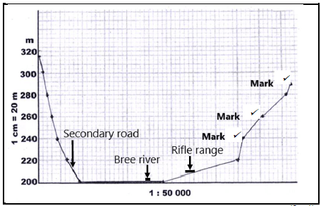
(3 x 1) (3)
2.2.2 Indicate the position of the following on the cross section drawn in QUESTION 2.2.1:
- Secondary road (see graph)
- Rifle range
- Breë River
(3 x 1) (3)
2.2.3 Calculate the vertical exaggeration of the cross-section. Show ALL calculations. Marks will be awarded for calculations.
Formula: ???????? ???????????? = ???????? ?????
?????????? ?????
- VS = 1 cm : 20 m
VS = 1 cm : (20 x 100) cm
VS = 1 : 2 000 ?
HS = 1 : 50 000 ?
?? = 1/2 000
1/50 000
= 1 × 50 000
2 000 x 1 ?
= 25 times ? (4 x 1) (4)
2.2.4 Would the vertical exaggeration of the cross-section make the interpretation of the landscape easier or more difficult?
Give a reason for your answer.
Answer: Easier (1 x 1) (1)
Reason:
- The shape of the features on the landscape is clearer when the vertical scale is made larger/enlarged/exaggeration is increased.
- To represent the topography of the landscape.
- To emphasise vertical features which are too small to identify relative to the horizontal scale.
- By increasing the vertical exaggeration, the topography and gradient can be seen more clearly.
- Specific features are more recognisable /clearer.
- Without vertical exaggeration the cross-section would be flat.
- Larger exaggeration creates a clearer impression of the landscape.
[Any ONE] (1 x 1) (1)
2.3 Refer to area 6 on the orthophoto map.
2.3.1 Calculate the area of the railway shed 6 on the orthophoto map, in m². Show ALL calculations. Marks will be awarded for calculations. Clearly indicate the unit of measurement in your answer.
- 3,5 (cm) x 100 = 350 m [3,4 cm to 3,6 cm] [Range: 340 m – 360 m]
35 (mm) x 10 = 350 m
2,2 ( cm) x 100 = 220 m [2,1 cm to 2,3 cm] [Range: 210 m – 230 m]
22 (mm) x 10 = 220 m
350 m x 220 m = 77 000 m² [Range: 71 400 m² – 82 800 m²]
[Length x Breadth must be in correct sequence.] (5 x 1) (5)
2.3.2 The area 6 on the orthophoto map is the same as the area of railway shed P on the topographical map. Explain why it appears to be smaller on the topographical map.
- The scale of the topographical map is 1 : 50 000 and the scale of the orthophoto map is 1 : 10 000.
- This indicates that the scale of the topographical map is 5 times smaller than the scale of the orthophoto map, making the railway shed area appear smaller on the topographical map.
[Any ONE] (1 x 1) (1)
[20]
QUESTION 3: APPLICATION AND INTERPRETATION
3.1 Refer to the area in blocks A6 to B6 on the topographical map.
3.1.1 Name the nocturnal (night) wind that occurs between X and Y.
- Katabatic (1 x 1) (1)
3.1.2 On the cross-section below, indicate the following:
- Wind direction of the wind named in QUESTION 3.1.1
- Position of Altona

(2 x 1) (2)
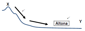
3.1.3 Explain how frost will influence the type of crops farmed at Altona.
- Cold dense air moves downslope causing the dew point temperature to drop below freezing point (0°C) leading to frost – freezes non-frost resistant plants.
(1 x 2) (2)
3.2 Refer to blocks D4 and E5 on the topographical map.
3.2.1 Name ONE landform of fluvial deposition in blocks D4 and E5.
- Floodplain (1 x 1) (1)
3.2.2 Is laminar or turbulent river flow found in blocks D4 and E5? Motivate using evidence to support answer.
Answer: Laminar
Evidence:
- The river is in the lower course/plain/old stage
- The slope is gentle/gentle gradient depositing load
- Wide river
- Marshes
- Floodplain
[Any ONE] (1 + 1 x 2) (3)
3.3 Worcester enjoys an excellent location as a gap town. With reference to this statement:
3.3.1 Explain the meaning of the term gap town.
- A town located at a gap between hills, providing a good defensive site and route centre that led to a trade and market function.
- A town located between or at the entrance of two mountains or poort.
[Any ONE ] [Concept] (1 x 2) (2)
3.3.2 Give TWO map evidences to support the statement that Worcester is a gap town.
- Found at the bottom of the Du Toitskloof / Slanghoek (Huguenot Tunnel) mountain range/pass.
- People using the N2 will stop and buy goods at local businesses and encourages economic growth.
- Encourages tourism
- Encourages trade of goods
- Industrialisation
[Any TWO] (2 x 2) (4)
3.4 Refer to 7 on the orthophoto map.
3.4.1 Is residential area 7 a high- or low-income residential area? Give a reason for your answer.
Answer: High-income residential area
Reason:
- Houses are large
- Stands are large
- High lying – scenic view
- Low density
- Close to golf course / woodland / Veld reserve
- [Any ONE] (1 + 1 x 2) (3)
3.5 Refer to the area demarcated by a white line in the north-east corner on the orthophoto map.
3.5.1 Is the wine cellar / factory at 8 on the orthophoto map market- orientated or raw material-orientated? Give a reason for your answer.
Answer: Raw-material orientated
Reason:
- It is situated close to the raw material – grapes (Vineyard fields)
- Processing occurs near the raw material
[Any ONE] (3) (1 + 1 x 2)
3.5.2 Suggest how the wine cellar / factory in QUESTION 3.5.1 can improve the local economy of Worcester.
- Worcester can have a wine festival.
- Tours can be organized through the vineyards and wineries.
- They could have wine tasting tours.
- Tourists bring money into the town.
- Jobs are created (in manufacturing of grape products/ processing).
- Export of grape products will boost the local economy.
- Improved infrastructure attracts business (can give examples).
- Multiplier effect will result in more economic development.
- Selling grape products (can give examples) to the locals/tourists. [Any TWO] (2 x 2) (4)
[25]
QUESTION 4: GEOGRAPHICAL INFORMATION SYSTEMS (GIS)
4.1 During a major flooding disaster, accessibility to the Brandvlei Dam in blocks E6 and F6 on a topographical map, would be limited. To determine the extent of the damage, remote sensing could be a useful tool.
4.1.1 Give an example of a remote sensing device that can be used to capture the extent of the damage due to flooding.
- Satellites/drones
NOTE: Do not accept hand-held camera/ camera.(1) (1 x 1) (1)
4.1.2 Explain how remote sensing could assist in monitoring the environmental impact of flooding in the area.
- Photographs can be taken over specific periods to analyse the environmental impact over time along the Holsloot River.
- Data about environmental damage can be collected for farmers.
- Large areas can be captured as images to see environmental impact in the area created from farming.
- Information could be used to determine the areas most affected and strategies put in place that would focus on those areas.
- It can be used to track environmental changes and development in an area over time.
- Information can be used to educate farmers / locals about the importance of being environmentally sensitive.
[Any TWO]
(2 x 2) (4)
4.2 A farmer decides to use data manipulation on his farm situated in blocks
- G9 and 10.
4.2.1 Explain the term data manipulation.
- When different layers of data are standardised and integrated to study a specific problem/query [CONCEPT] (1 x 1) (1)
4.2.2 Evaluate how data manipulation assists farmers in blocks G9 and 10 to practise sustainable farming methods.
- The farmer will evaluate the gradient
- Drainage density
- Soil profile (data layer)
- To describe what product, type of farm and farming methods to use to gain max use of area
[Any TWO] (2 x 2) (4)
4.3 The sketch map below is a plan view of the Aan de Doorns settlement and its attribute data, located in block F10 and G10.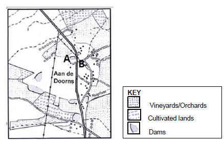
4.3.1 Define the term attribute data.
- Information that describes the spatial objects or features
[CONCEPT] (1 x 1) (1)
4.3.2 Use the symbols (letters of the alphabet) shown in the key above to locate the position of the following attribute data for the Aan de Doorns settlement on the sketch map.
- A – Cellar (See sketch map) ?
- B – School (See sketch map) ? (2 x 1) (2)
4.3.3 State TWO attributes of B – School in QUESTION 4.3.2.
- 33°41’52’’ S 19°29’39’’ E ?
- Located in Aan de Doorns 220 m (above sea level) ?
- Access by road (other road) / close to arterial road (R43)?
- Power line nearby ?
- SE of Worcester ?
[Any TWO] (2 x 1) (2)
[15]
TOTAL: 75