Geography Paper 2 Grade 12 Questions - NSC Past Papers And Memos September 2020 Preparatory Examinations
Share via Whatsapp Join our WhatsApp Group Join our Telegram GroupRESOURCE MATERIAL
- An extract from topographical map 3319 CB WORCESTER.
- Orthophoto map 3319 CB 15 WORCESTER.
- NOTE: The resource material must be collected by schools for their own use.
INSTRUCTIONS AND INFORMATION
- Write your NAME in the space provided on the cover page.
- Answer ALL the questions in the spaces provided in this question paper.
- You are provided with a 1 : 50 000 topographical map (3319CB WORCESTER) and an orthophoto map (3319 CB 15 WORCESTER) of a part of the mapped area.
- You must hand the topographical map and the orthophoto map to the invigilator at the end of this examination session.
- You may use the blank page at the end of this question paper for all rough work and calculations. Do NOT detach this page from the question paper.
- Show ALL calculations and formulae, where applicable. Marks will be allocated for these.
- Indicate the unit of measurement in the final answer of calculations, e.g. 10 km; 2,1 cm.
- You may use a non-programmable calculator and a magnifying glass.
- The area demarcated in BLACK AND RED on the topographical map represents the area covered by the orthophoto map.
- The following English terms and their Afrikaans translations are shown on the topographical map:
ENGLISH
Aerodrome
Golf course
Model aircraft club
Hospital
Sewerage works
Race track
Canal
Cemetery
Wine cellar
Horse riding club
Brickworks
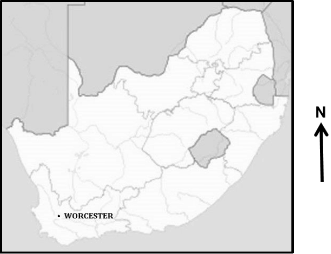
GENERAL INFORMATION ON WORCESTER Worcester is a gap town in the Western Cape, South Africa. It is located 120 kilometres north-east of Cape Town on the N1 highway through the Huguenot Tunnel or by driving through spectacular mountain passes north to Johannesburg.
Coordinates: 33°38ʹʹ42ʹS 19°26ʹʹ37ʹE |
QUESTIONS
QUESTION 1: MULTIPLE-CHOICE QUESTIONS
The questions below are based on the 1 : 50 000 topographical map (3319 CB WORCESTER) as well as the orthophoto map of the part of the mapped area. Various options are provided as possible answers to the following questions. Choose the answer and write only the letter (A–D) in the block next to each question.
1.1 The map index to sheet of the orthophoto map north of Worcester is …
- 3319 CB 9.
- 3319 DA 6.
- 3319 CB 10.
- 3319 CB 20.
1.2 The primary activity found at 1 on the orthophoto map is/an …
- orchards and vineyards.
- mining.
- cultivated lands.
- quarry.
1.3 The building at 2 on the orthophoto map is a …
- shop.
- hospital.
- school.
- factory.
1.4 The type of road labelled 3 on the orthophoto map is a/an … road.
- other
- main
- secondary
- arterial
1.5 The feature found at 4 on the orthophoto map is a …
- monument.
- golf course.
- cemetery.
- stadium.
1.6 The mean annual change on the topographical map is …
- 2’ Eastwards.
- 23°12’ West.
- 2’ Westwards.
- 23°12’ East.
1.7 The feature found at 33°39’45”S and 19°25’45”E on the topographical map is a …
- race track.
- caravan park.
- horse riding club.
- model aircraft club.
1.8 The fluvial landform along the Breë River in block E6 on the topographical map is a …
- waterfall.
- rejuvenation.
- rapid.
- braided stream.
1.9 The sewerage works found in block D8 is located in the …
- industrial zone.
- residential zone.
- rural-urban fringe.
- commercial zone.
1.10 The dominant drainage pattern in block E8 on the topographical map is …
- radial.
- centripetal.
- trellis.
- parallel.
1.11 The main street plan at K in block C7 on the topographical map is a/an … pattern.
- radial
- unplanned irregular
- gridiron
- planned irregular
1.12 The true bearing of bench mark 214,8 in block C3 from spot height 471, (L), in block A4 on the topographical map is …
- 16°.
- 216°.
- 46°.
- 164°.
1.13 A human factor responsible for the location of the industrial area at 5 on the orthophoto map is …
- stable ground.
- climate.
- transport.
- CBD.
1.14 The brickworks in block A1 on the topographical map is an example of a … activity.
- quaternary
- tertiary
- primary
- secondary
1.15 The landform at M in block G8 on the topographical map is a …
- saddle.
- spur.
- koppie.
- valley.
(15 x 1) [15]
QUESTION 2: MAPWORK CALCULATIONS AND TECHNIQUES
2.1 The magnetic declination in 2020 for the topographical map is 23°58' W of TN.
2.1.1 Will the declination become larger or smaller from the time it was surveyed? (1 x 1) (1)
2.1.2 Give a reason for your answer to QUESTION 2.1.1. (1 x 1) (1)
2.2 Refer to the line from N (block E3) to O (block C6) on the topographical map.
2.2.1 Complete a cross section from trigonometric station 59 (E3) to trigonometric station 207 (C6). Use the vertical interval of 1 cm = 20 m.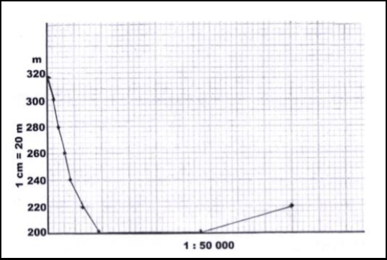
(3 x 1) (3)
2.2.2 Indicate the position of the following on the cross section drawn in QUESTION 2.2.1:
- Secondary road (see graph)
- Rifle range
- Breë River (3 x 1) (3)
2.2.3 Calculate the vertical exaggeration of the cross-section. Show ALL calculations. Marks will be awarded for calculations. (4 x 1) (4)
Formula: ???????? ???????????? = ???????? ?????
?????????? ?????
2.2.4 Would the vertical exaggeration of the cross-section make the interpretation of the landscape easier or difficulty?
Give a reason for your answer.
Answer: (1 x 1) (1)
Reason: (1 x 1) (1)
2.3 Refer to area 6 on the orthophoto map.
2.3.1 Calculate the area of the railway shed 6 on the orthophoto map, in km². Show ALL calculations. Marks will be awarded for calculations. Clearly indicate the unit of measurement in your answer. (5 x 1) (5)
2.3.2 The area 6 on the orthophoto map is the same as the area of railway shed P on the topographical map. Explain why it appears to be smaller on the topographical map. (1 x 1) (1)
[20]
QUESTION 3: APPLICATION AND INTERPRETATION
3.1 Refer to the area in blocks A6 to B8 on the topographical map.
3.1.1 Name the nocturnal (night) wind that occurs between X and Y. (1 x 1) (1)
3.1.2 On the cross-section below, indicate the following:
- Wind direction of the wind named in QUESTION 3.1.1
- Position of Altona
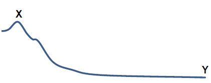
(2 x 1) (2)
3.1.3 Explain how frost will influence the type of crops farmed at Altona. (1 x 2) (2)
3.2 Refer to blocks D4 and E5 on the topographical map.
3.2.1 Name ONE landform of fluvial deposition in blocks D4 and E5. (1 x 1) (1)
3.2.2 Is laminar or turbulent river flow found in blocks D4 and E5? Motivate using evidence to support answer.
Answer:
Evidence: (1 + 1 x 2) (3)
3.3 Worcester enjoys an excellent location as a gap town. With reference to this statement:
3.3.1 Explain the meaning of the term gap town. (1 x 2) (2)
3.3.2 Give TWO map evidences to support the statement that Worcester is a gap town. (2 x 2) (4)
3.4 Refer to 7 on the orthophoto map.
3.4.1 Is the residential area 7 a high- or low-income residential area? Give a reason for your answer.
Answer:
Reason: (1 + 1 x 2) (3)
3.5 Refer to the area demarcated with a white line in the north-east corner on the orthophoto map.
3.5.1 Is the wine cellar / factory at 8 on the orthophoto map market- orientated or raw material-orientated? Give a reason for your answer.
Answer:
Reason: (1 + 1 x 2) (3)
3.5.2 Suggest how the wine cellar / factory in QUESTION 3.5.1 can improve the local economy of Worcester. (2 x 2) (4)
[25]
QUESTION 4: GEOGRAPHICAL INFORMATION SYSTEMS (GIS)
4.1 During a major flooding disaster, accessibility to the Brandvlei Dam in blocks E6 and F6 on topographical map, would be limited. To determine the extent of the damage, remote sensing could be a useful tool.
4.1.1 Give an example of a remote sensing device that can be used to capture the extent of the damage due to flooding. (1 x 1) (1)
4.1.2 Explain how remote sensing could assist in monitoring the environmental impact of flooding in the area. (2 x 2) (4)
4.2 A farmer decides to use data manipulation on his farm situated in blocks G9 and 10.
4.2.1 Explain the term data manipulation. (1 x 1) (1)
4.2.2 Evaluate how data manipulation assists farmers in blocks G9 and 10 to practise sustainable farming methods. (2 x 2) (4)
4.3 The sketch map below is a plan view of the Aan de Doons settlement and its attribute data, located in block F10 and G10.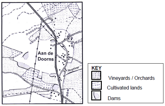
4.3.1 Define the term attribute data. (1 x 1) (1)
4.3.2 Use the symbols (letters of the alphabet) shown in the key below to locate the position of the following attribute data for the Aan de Doons settlement on the sketch map.
- A – Cellar
- B – School (2 x 1) (2)
4.3.3 State TWO attributes of B – School in QUESTION 4.3.2. (2 x 1) (2)
[15]
TOTAL: 75