GEOGRAPHY GRADE 12 ANNEXURE - NSC PAST PAPERS AND MEMOS NOVEMBER 2019
Share via Whatsapp Join our WhatsApp Group Join our Telegram GroupGEOGRAPHY
GRADE 12
ANNEXURE
NOVEMBER 2019
NATIONAL SENIOR CERTIFICATE
FIGURE 1.3: CASE STUDY OF A TROPICAL CYCLONE THAT RECENTLY AFFECTED SOUTHERN AFRICA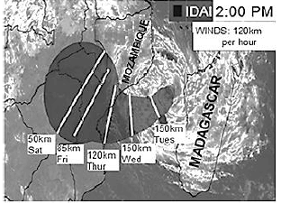
Tropical cyclone Idai has quickly strengthened into an intense tropical cyclone and has been fluctuating (changing) in intensity over the past 48 hours. An intense tropical cyclone is equivalent to a category 3 hurricane.
Idai is slowly moving in a westerly direction towards Mozambique with wind speeds exceeding 170 km/h closer to the eye.
It is expected to reach the coastal area near Beira, Mozambique's fourth largest city with 530 000 residents, before midnight on Thursday.
FIGURE 1.4: SOUTH AFRICAN BERG WINDS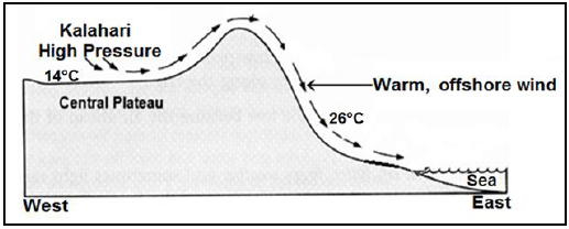
FIGURE 1.5: RIVER CAPTURE (STREAM PIRACY)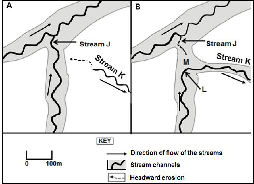
FIGURE 1.6: CATCHMENT AND RIVER MANAGEMENT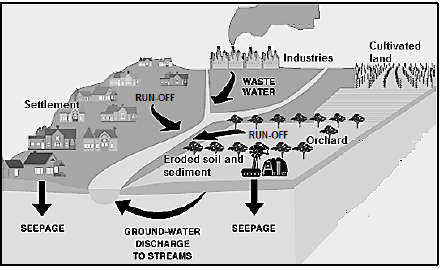
FIGURE 2.1: MID-LATITUDE CYCLONE – STAGES OF DEVELOPMENT AND RELATED WEATHER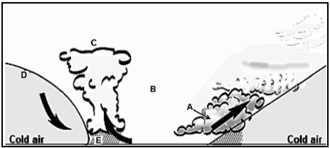
FIGURE 2.3: READING AND INTERPRETING SYNOPTIC WEATHER MAPS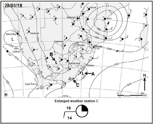
FIGURE 2.4: DIFFERENCES BETWEEN RURAL AND URBAN CLIMATES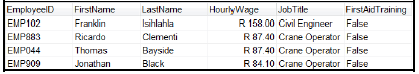
FIGURE 2.5: RIVER PROFILES
FIGURE 2.6: FLUVIAL LANDFORMS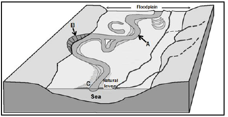
FIGURE 3.3: RURAL SETTLEMENT ISSUES: LAND REFORM STATE-OWNED 'LAND PARCELS' IDENTIFIED FOR EXPROPRIATION – RAMAPHOSA
President Cyril Ramaphosa says state-owned 'land parcels' have been identified for the purpose of *expropriation without compensation. Ramaphosa delivered his 2019 State of the Nation Address (SONA) in February 2019. An advisory panel of experts was put in place to advise government on its land reform programme. 'As part of accelerating land reform, we have identified land parcels owned by the state for redistribution,' President Ramaphosa stated. With regard to an agriculture stimulatory package, Ramaphosa said government had invested a lot in comprehensive farmer development support to ensure that restituted and communal land was productively used. Government would continue to give importance to targeted skills development and capacity building programmes for emerging farmers. *Expropriation: the act of a government in taking privately owned property, seemingly to be used for purposes designed to benefit the overall public
FIGURE 3.4: URBANISATION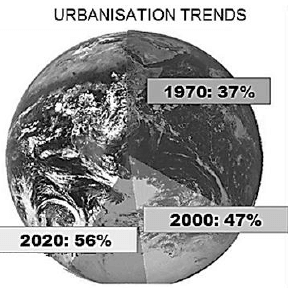
FIGURE 3.5: THE IMPORTANCE OF FOOD SECURITY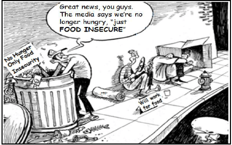
FIGURE 3.6: STRATEGIES FOR INDUSTRIAL DEVELOPMENT: RICHARDS BAY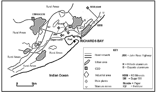
FIGURE 4.1: RURAL AND URBAN SETTLEMENTS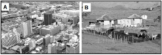
FIGURE 4.3: THE RELATIONSHIP BETWEEN URBAN LAND-USE ZONES AND BUILDING DENSITY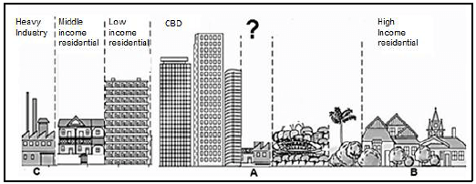
FIGURE 4.4: INFORMAL SETTLEMENTS AND ASSOCIATED ISSUES
Durban – Most of the major fires attended to in recent years by the eThekwini Fire department were in informal settlements. In July, a fire engulfed (surrounded) 300 shacks at the Kennedy Road Informal Settlement and killed Thembinkosi Mncwango. Winter is especially a time to be on high alert as there is an increase of fires breaking out. It took fire fighters 10 hours to put out the fire that rapidly spread through the informal settlement. In May, children aged between 4 and 7 years, died while sleeping in a shack when it caught alight (burning) in Verulam. Existing settlements remain at risk due to the nature of construction material used, spacing among shacks, emergency accessibility challenges and human behaviour among other causes.
FIGURE 4.5: SOUTH AFRICAꞌS INDUSTRIAL REGIONS:PORT ELIZABETH-UITENHAGE (NELSON MANDELA METROPOLE)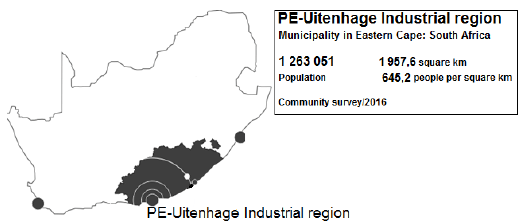
The PE-Uitenhage industrial region, covering an area of 1 957,6 km², is situated on the wetter eastern half of South Africa, in the Eastern Cape. It has a major natural bay seaport and is the economic powerhouse of the Eastern Cape. Main economic sectors: Manufacturing (25%), community services (23%), finance (23%), trade (13%) and transport (13%) The automotive industry is one of the main contributors to the area's economic growth. The PE-Uitenhage industrial region is home to two major automotive manufacturers, namely Volkswagen and General Motors South Africa. In addition, there are over 150 vehicle component manufacturers in the region.
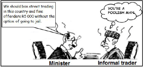
FIGURE 4.6: THE INFORMAL SECTOR