Geography P2 Grade 12 Questions - NSC Exams Past Papers and Memos September 2019 Preparatory Examinations
Share via Whatsapp Join our WhatsApp Group Join our Telegram GroupRESOURCE MATERIAL
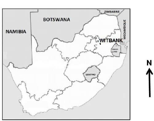
- An extract from topographical map 2529CC WITBANK.
- Orthophoto map 2529 CC 15 WITBANK.
- NOTE: The resource material must be collected by schools for their own use.
INSTRUCTIONS AND INFORMATION
- Write your NAME in the space provided on the cover page.
- Answer ALL the questions in the spaces provided in this question paper.
- You are provided with a 1 : 50 000 topographic map (2529CC WITBANK) and an orthophoto map (2529 CC 15 WITBANK) of a part of the mapped area.
- You must hand in the topographic map and the orthophoto map to the invigilator at the end of this examination session.
- You may use the blank page at the end of this question paper for all rough work and calculations. Do NOT detach this page from the question paper.
- Show ALL calculations and use the formulae provided, where applicable. Marks will be allocated for these.
- Indicate the unit of measurement in the final answer of calculations, e.g. 10 km; 2,1 cm.
- You may use a non-programmable calculator and a magnifying glass.
- The area demarcated in RED on the topographic map represents the area covered by the orthophoto map.
- The following English terms and their Afrikaans translations are shown on the topographic map:
ENGLISH AFRIKAANS Aerodrome
Golf course
Diggings
Hospital
Sewerage works
Shaft
Slimes Dam
Furrow
Subsiding groundVliegveld
Gholfbaan
Uitgrawings
Hospitaal
Rioolwerke
Skag
Slykdam
Voor
Ondergrondse grond
GENERAL INFORMATION ON WITBANK Witbank, renamed eMalahleni in 2006, is a city situated on the Highveld of Mpumalanga, South Africa, within the eMalahleni local municipality. The city is known for the coal-mining in the surrounding region.
[Source: Examiner] |
QUESTIONS
QUESTION 1: MULTIPLE-CHOICE QUESTIONS
The questions below are based on the 1 : 50 000 topographic map (2529CC WITBANK) as well as the orthophoto map of the part of the mapped area. Various options are provided as possible answers to the following questions. Choose the answer and write only the letter (A–D) in the block next to each question.
1.1 The city situated along the N4 easterly of Witbank is …
- Bloemfontein.
- Richards Bay.
- Pretoria.
- Middelburg.
1.2 The major mineral mined around the Witbank area is …
- platinum.
- coal.
- diamonds.
- iron ore.
1.3 In the map index of 2529 CC, the 29 represents …
- 29° south of the equator.
- 29° west of the Greenwich Meridian.
- 29° north of the equator.
- 29° east of the Greenwich Meridian.
1.4 The human-made feature A in block G10 on the topographic map is a …
- conveyor belt.
- mine dump.
- slime dam.
- hill.
1.5 … aerial photographs are used to create the orthophoto map.
- Horizontal
- Satellite
- Vertical
- Oblique
1.6 The human-made feature 1 on the orthophoto map is a …
- dam.
- reservoir.
- building.
- water tower.
1.7 The difference in height between spot height 1554 in block H10 and trigonometrical station 156 in block H12, is … m.
- 20
- 2,0
- 21
- 20,9
1.8 The feature found at 2 on the orthophoto map is a ...
- golf course.
- Witbank industrial area.
- school.
- King George Park.
1.9 The human-made feature at 3 on the orthophoto map is a …
- sewage works.
- dam.
- reservoir.
- slimes dam.
1.10 The dominant street pattern at B in block C12 on the topographic map is a … pattern.
- radial
- unplanned irregular
- gridiron
- planned irregular
1.11 The type of mining used to extract minerals that supply the Greenside Colliery in block H8 is …
- dredging.
- opencast.
- fracking.
- shaft.
1.12 The type of commercial area found at 4 on the orthophoto is a/an …
- outlying business district.
- regional shopping centre.
- neighbourhood shopping centre.
- isolated shopping centre.
1.13 The pattern of the rural settlements within C in block B3 on the topographic map is …
- nucleated.
- linear.
- isolated.
- stellar.
1.14 The main land-use zone found in block D10 on the topographic map is/the …
- rural-urban fringe.
- residential.
- commercial.
- light industry.
1.15 The general direction of flow of river H in block H2 is …
- north.
- south-west.
- north-west.
- south.
(15 x 1) [15]
QUESTION 2: MAPWORK CALCULATIONS AND TECHNIQUES
2.1 Products from Witbank are transported along the N4 national road to Pretoria.
2.1.1 Determine if vehicles travelling along the N4 from 5 to 6 on the orthophoto map will drive uphill or downhill.(1 x 1) (1)
2.1.2 Give a reason for your answer to QUESTION 2.1.1.(1 x 1) (1)
2.2 Locate line 7–8 on the orthophoto map.
2.2.1 Calculate the average gradient between the car park point 7 (1593) and 8 on the orthophoto map. Show ALL calculations. Marks will be awarded for calculations.
Formula: Gradient = Vertical Interval (V.I.) (5 x 1) (5)
Horizontal Equivalent (H.E.)
2.3 2.3.1 Calculate the magnetic bearing from point D, in block B5, to point E in block C4 for 2019. Show ALL calculations. Marks will be awarded for calculations.
Formula: MB = TB + MD (7 x 1) (7)
2.3.2 State the importance of calculating the magnetic declination for the present year. (1 x 1) (1)
2.4 Calculate the area of block A1 on the topographical map in km². Show ALL calculations. Marks will be awarded for calculations. Clearly indicate the unit of measurement in your answer.
Formula: area = length (L) x breadth (B) (5 x 1) (5) [20]
QUESTION 3: APPLICATION AND INTERPRETATION
3.1 Study the Ferrobank industrial area in block B8.
3.1.1 Is Ferrobank a light or heavy industrial area?(1 x 1) (1)
3.1.2 Substantiate your choice in QUESTION 3.1.1.(1 x 2) (2)
3.2 Witbank is a central place town according to its main function.
3.2.1 Define a central place town.(1 x 1) (1)
3.2.2 Provide topographic and orthophoto map evidences that Witbank is a central place town.(2 x 2) (4)
3.3 Refer to block E10 on the topographic map.
3.3.1 Name TWO natural factors that would discourage mining in block E10 on the topographic map.(2 x 1) (2)
3.3.2 Explain your answer in QUESTION 3.3.1.(2 x 2) (4)
3.4 Infrastructure is important for mining in the region. Refer to the Greenside Colliery Mine in blocks H8 and H9 on the topographic map to answer the following questions.
3.4.1 State a form of infrastructure used by the Greenside Colliery Mine.(1 x 1) (1)
3.4.2 Explain why the infrastructure mentioned in QUESTION 3.4.1 is of importance to the Greenside Colliery Mine.(2 x 2) (4)
3.5 Refer to blocks H2 and H3 on the topographic map.
3.5.1 Witbank experiences seasonal rainfall. Give reasons evident in block H2.(2 x 2) (4)
3.5.2 Explain how seasonal rainfall has influenced the location of the cultivated land in block H3.(1 x 2) (2)[25]
QUESTION 4: GEOGRAPHICAL INFORMATION SYSTEMS (GIS)
4.1 Refer to the picture below of a slimes dam used in the Witbank area below and answer the questions that follow.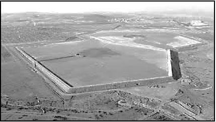
[Source: Google]
4.1.1 What type of spatial object is the slimes dam?(1 x 1) (1)
4.1.2 Is the picture a raster or vector image?(1 x 1) (1)
4.1.3 GIS can be used to predict the amount of water and disposable material entering the dam by integrating different sources of information. What is the term used to describe this process?(1 x 1) (1)
4.2 The farmer in block H1 decides to use data manipulation to assist in maximising his output and profit from his crop farming.
4.2.1 Explain the term data manipulation.(1 x 1) (1)
4.2.2 Evaluate how data manipulation would assist the farmer in block H1 in maximising his output and profit.(2 x 2) (4)
4.3 Refer to area within F in block A5 on the topographic map in which buffering has occurred.
4.3.1 Define buffering.(1 x1) (1)
4.3.2 What evidence is there that buffering has occurred?(1 x 2) (2)
4.3.3 Explain the positive impact that buffering will have on environmental sustainability in the area in the case of pollution.(2 x 2) (4)[15]
TOTAL: 75