GEOGRAPHY PAPER 1 GRADE 12 MEMORANDUM - NSC PAST PAPERS AND MEMOS MAY/JUNE 2019
Share via Whatsapp Join our WhatsApp Group Join our Telegram GroupGEOGRAPHY PAPER 1
GRADE 12
NATIONAL SENIOR CERTIFICATE EXAMINATIONS
MEMORANDUM
MAY/JUNE 2019
Marking Guidelines
The following marking guidelines have been developed to standardise marking in all provinces.
Marking
- ALL selected questions MUST be marked, irrespective of whether it is correct or incorrect
- Candidates are expected to make a choice of THREE questions to answer. If all questions are answered, ONLY the first three questions are marked.
- A clear, neat tick must be used: ✓
- If ONE mark is allocated, ONE tick must be used: ✓
- If TWO marks are allocated, TWO ticks must be used: ✓✓
- The tick must be placed at the FACT that a mark is being allocated for
- Ticks must be kept SMALL, as various layers of moderation may take place
- Incorrect answers must be marked with a clear, neat cross: ✓
- Use MORE than one cross across a paragraph/discussion style questions to indicate that all facts have been considered
- Do NOT draw a line through an incorrect answer
- Do NOT underline the incorrect facts
- Where the maximum marks have been allocated in the first few sentences of a paragraph, place an over the remainder of the text to indicate the maximum marks have been achieved
For the following action words, ONE word answers are acceptable: give, list, name, state, identify
For the following action words, a FULL sentence must be written: describe, explain, evaluate, analyse, suggest, differentiate, distinguish, define, discuss, why, how
The following action words need to be read within its context to determine whether a ONE word answer or FULL sentence is required: provide, what, tabulate
Totalling and transferring of marks
- Each sub-question must be totalled
- Each question has six sub-sections, therefore six sub-totals per question required
- Sub-section totals to be written in right hand margin at the end of the sub-section and underlined
- Sub-total must be written legibly
- Leave room to write in moderated marks on different levels
- Total sub-totals and transfer total to top left hand margin next to question number
- Transfer total to cover of answer book
Moderation
Marking on each level of moderation is done in the same way as the initial marking. All guidelines for marking must be adhered to.
If a mark for a sub-question is changed after moderation, the moderator must strike through the markerˈs mark and write down the new mark. 12 16
The total for the question must be re-calculated, and similarly be struck off and the new total to be written down.
QUESTION 1
1.1.1 A (South Atlantic High) (1)
1.1.2 B (Kalahari High) (1)
1.1.3 B (South Indian) (1)
1.2.1 Melting snow
1.2.2 Mouth
1.2.3 Third order
(2)
1.3.1 Katabatic
1.3.2 1 occurs during the day while 2 occurs at night
1.3.3 Cold air rolls down into the valley and forms an inversion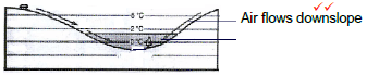 (6)
(6)
1.4.1 Shape of front concave
Steep gradient of front
1.4.2 Warm air undercuts the cold air
1.4.3 Air behind the cold front is colder than the air in front. Cold air moves faster than warm air ahead of it. Cold front catches up with the warm front.
(7)
1.5.1
- A river that only flows all year round
- The river channel is wide
- Regularity of rainfall and the soil type over which the streams flow. (4)
1.6.1 Gauteng and the Eastern Cape
1.6.2 Mining waste dumped in the river and industries pollute the water.
1.6.3 The cost of food production will increase at it is costly to buy purified water. Farmers will have to buy more chemicals to purify water. Chemicals cost a lot and this will increase production costs. It will be costly to purify water for use in electricity generation. These costs will be included in electricity prices. Costs will increase the price of electricity during production. There will be less clean water to generate hydro electricity. (11)
SECTION A: CLIMATE, WEATHER AND GEOMORPHOLOGY
QUESTION 1
1.1
1.1.1 cumulonimbus (1)
1.1.2 convection (1)
1.1.3 eye (1)
1.1.4 stable (1)
1.1.5 convergence (1)
1.1.6 thunderstorms (1)
1.1.7 warm (1) (7 x 1) (7)
1.2
1.2.1 G (Oxbow lake) (1)
1.2.2 E (Leveé) (1)
1.2.3 A (Braided stream) (1)
1.2.4 H (Rapids) (1)
1.2.5 B (Delta) (1)
1.2.6 F (Waterfall) (1)
1.2.7 C (Undercut) (1)
1.2.8 D (Meander) (1) (8 x 1) (8)
1.3
1.3.1 South Atlantic (High) (1)
(Accept St Helena (High)) (1 x 1) (1)
1.3.2 Highest air pressure (1 024 hPa/mb) is in the centre (2)
Air pressure increases towards the centre (2)
[ANY ONE] (1 x 2) (2)
1.3.3 Anticlockwise (divergence) circulation around the high pressure carries cold, drier air towards the land where it condenses to form fog (2) (1 x 2) (2)
1.3.4 The ITCZ (heat equator) migrates (moves) northwards in winter (2)
Sun directly overhead in the Northern Hemisphere/Tropic of Cancer (2)
In winter all pressure systems migrate (move) north with the apparent movement of the sun (2)
[ANY TWO] (2 x 2) (4)
1.3.5 The South Indian High (B) is in the path of mid-latitude cyclone (2)
Anticyclone (B) thus occupies a blocking position/preventing MLC from moving eastwards (2)
Mid-latitude cyclone is forced to move in a south-easterly direction (2)
[ANY ONE] (1 x 2) (2)
1.3.6 The fetch (distance) of the wind from B has a shorter distance to travel/B is closer to the coastline in winter (2)
This results in less moisture being fed onto the land (2)
Increased sinking air associated with less condensation (2)
There will be less rainfall because of these conditions (2) [THESE TWO MARKS CAN ONLY BE AWARDED ON CONDITION THAT REFERENCE HAS BEEN MADE TO THE EXPLANATIONS]
[ANY TWO] (2 x 2) (4)
1.4
1.4.1 night (1) (1 x 1) (1)
1.4.2
- frost (1) (1 x 1) (1)
- radiation fog (1) (1 x 1) (1)
1.4.3 Wind B is cold air that is heavy and drains onto the valley floor (2)
This cold air converges on the valley floor and displaces the warm air in the valley and forces it to rise (2)
This warm air causes an increase in temperature with height which is an inversion (2)
[ANY TWO] (2 x 2) (4)
1.4.4 RADIATION FOG
Affects visibility for motorists and other activities (2)
Slows traffic and people are late for work/higher fuel costs (2)
Risk of accidents increase (2)
Constant dampness makes/creates uncomfortable conditions for people (2)
Combines with pollutants to form smog which causes health issues (2)
AND/OR
FROST
Farmers are only able to plant frost resistant crops on the valley floor (2)
Difficult to live on the valley floor because the temperature is low (2)
It is more expensive because it will require artificial heating (2)
People can fall ill due to cold conditions (2)
Reduction in income as farming activities are reduced (2)
[ANY FOUR. ACCEPT IF CANDIDATE REFERS TO ONE ASPECT ONLY. IF CANDIDATES REFER TO BOTH IT IS ALSO ACCEPTABLE] (4 x 2) (8)
1.5
1.5.1 It refers to the way in which streams are arranged in a drainage basin/The description of the pattern of a river system/streams in a drainage basin/Surface pattern formed by the river and its tributaries (1)
[CONCEPT] (1 x 1) (1)
1.5.2 It resembles the branches of a tree (2) (1 x 2) (2)
1.5.3 Dendritic: Tributaries join at acute angles (2)
Trellis: Tributaries join main stream at 90° angle (2)
Dendritic: Long tributaries (2)
Trellis: Short tributaries (2)
OR
The dendritic pattern (2) has longer (2) tributaries
OR
The trellis pattern (2) has shorter (2) tributaries
[ANY ONE RELATED DIFFERENCE. NO PART MARKS] (2 x 2) (4)
1.5.4 Dendritic
The underlying rock structure is massive/uniformly/equally resistant to erosion (2)
Trellis
Varying resistance to erosion/folded rock structure/Alternative layers of hard and soft rock/Inclined rock strata (2) (2 x 2) (4)
1.5.5 In the dendritic pattern water is widely distributed in the drainage basin and water is accessible (2)
Longer tributaries therefore water is more accessible (2)
Occurs over flat/gentle land (middle/lower course) thus more suitable for farming (2)
Larger floodplains with access to fertile soils (2)
[ANY TWO] (2 x 2) (4)
1.6
1.6.1 Vertical (Accept downward) (1) (1 x 1) (1)
1.6.2 Upliftment (1)
Entrenched/Incised meanders (1)
[ANY ONE] (1 x 1) (1)
1.6.3 Isostatic uplift/Tectonic forces (1) (1 x 1) (1)
1.6.4 Steeper slopes make it unsuitable for human living (2)
Deeper gorges makes farming activity impossible (2)
Building infrastructure will be more expensive (2)
More specialised farming machinery will be needed (2)
Water will not be easily accessible for human usage (2)
Narrow floodplains reduce fertile farming land (2)
[ANY TWO] (2 x 2) (4)
Difference must be qualified
Difference must be qualified
1.6.5 A knick point will develop between the old and the new point of erosion (2)
Waterfalls develop at the knick point where there is a sharp change in gradient (2)
Vertical (accept downward) erosion results in (paired) terraces (2)
Valleys within valleys develop as a result of a new valley floor (2)
Meanders deeply erode to form entrenched or incised meanders (2)
Floodplains are narrowed (2)
[ALSO ACCEPT THE FOLLOWING]
Higher velocity may remove some braided streams (2)
Higher velocity may break through the levees (2)
Higher velocity may wash the existing deltas away (2)
Higher velocity may result in more oxbow-lakes (2)
[ANY FOUR] (4 x 2) (8)
[75]
QUESTION 2
2.2
2.2.1 D/source (1)
2.2.2 A/watershed (1)
2.2.3 H/confluence (1)
2.2.4 B/floodplain (1)
2.2.5 G/interfluve (1)
2.2.6 C/mouth (1)
2.2.7 E/drainage basin (1) (7 x 1) (7)
2.3
2.3.1 South (1) (1 x 1) (1)
2.3.2 Air movement is clockwise indicated by the arrows (1)
Symbol in this diagram implies clockwise circulation (1)
Warm front located east of the cold front (in the Southern Hemisphere) (1)
The warm sector lies to the north of the cold sector (in the Southern Hemisphere) (1)
The V of the warm sector points southwards (in the Southern Hemisphere) (1) [ANY ONE] (1 x 1) (1)
2.3.3 Polar front (1) (1 x 1) (1)
2.1
2.1.1 isotherms (1)
2.1.2 A (1)
2.1.3 A to B (1)
2.1.4 B to A (1)
2.1.5 B (1)
2.1.6 A (1)
2.1.7 B (1)
2.1.8 A (1) (8 x 1) (8)
2.3.4
| Cold sector | Warm sector |
|
|
[ANY ONE DIFFERENCE]
In the cold sector (2) the air is drier (2)
In the warm sector (2) the air is more moist (2)
In the cold sector (2) the air is denser and heavier (2)
In the warm sector (2) the air is lighter and less dense (2)
In the cold sector (2) the temperature is lower (2)
In the warm sector (2) the temperature is higher (2)
In the cold sector (2) the pressure is higher (2)
In the warm sector (2) the pressure is lower (2)
In the cold sector (2) south-easterly/south-westerly winds occur (2)
In the warm sector (2) north-westerly winds occur (2)
The cold sector (2) is behind the cold front (2)
The warm sector (2) is behind the warm front (2)
[ANY ONE. THE SECTOR WITH THE QUALIFICATION] (2 x 2) (4)
2.3.5 The leading edge of the cold front catches up with warm front at the apex (2)
Cold air undercuts the warm air and it is displaced and uplifted (2)
Cold and warm front merges/joins (2)
[ANY TWO] (2 x 2) (4)
2.3.6 Weather will be stable with clear skies and sunny conditions (2)
No rain which makes it suitable for outdoor activities (2)
Moderate temperatures which will be pleasant for outdoor activity (2)
Moderate to light winds make outdoor activities possible (2)
[ANY TWO] (2 x 2) (4)
2.4
2.4.1 Winter (1) (1 x 1) (1)
2.4.2 The presence of the Kalahari High Pressure Cell (in the interior) (1)
The presence of berg winds (1)
Kalahari High is close to the surface (1)
[ANY ONE] (1 x 1) (1)
2.4.3 Blows from the Kalahari High Pressure to coastal low (1)
Blows down the escarpment to coastal low (1)
Blows down the mountain to the ocean (1)
[ANY ONE] (1 x 1) (1)
2.4.4
- A - offshore (1)
B - onshore (1) (2 x 1) (2) - Lack of moisture because air blows from the land to the sea (2)
Air subsides therefore no condensation (2)
[ANY ONE] (1 x 2) (2) - NEGATIVE
Warm, dry wind increases surface water evaporation (2)
Warm winds dry out the vegetation (2)
Dry vegetation could result/facilitate veld fires (2)
The gusty winds could fan and spread the fire (2)
Veld fires destroy ecosystems/habitats (2)
Biodiversity is reduced (2)
Food chains are disrupted (2)
Destruction of vegetation can result in bare soil and soil erosion (2)
Soil erosion will decrease soil fertility (2)
POSITIVE
Raises the temperature of coastal areas in winter (2)
Veld fires encourage regrowth and regeneration of natural vegetation (2)
[ANY FOUR] (4 x 2) (8)
2.5
2.5.1 Permanent rivers flow throughout the year (1) and episodic rivers flow only for a few hours after heavy rainfall or thunderstorms (1)
[CONCEPT] (2 x 1) (2)
2.5.2 The water table is above the river bed (2) (1 x 2) (2)
2.5.3 Low or sporadic rainfall to feed the ground water level (2)
High evaporation rate from the soil (2)
More permeable rocks results in deeper infiltration (2)
Longer periods of drought (2)
Drier soils absorb water easily (2)
Overuse of underground water (2)
[ANY TWO] (2 x 2) (4)
2.5.4 More overland flow would result in more water reaching the stream (2)
Water level in stream will rise (2)
Greater possibility for flooding to occur (2)
Less infiltration will cause the water table to drop in the dry season (2)
Increased erosion will increase the stream load (2)
Increased deposition would make the stream shallower (2)
Destabilisation of the river banks/levees (2)
Disruption of aquatic ecosystems/food webs/food chains (2)
[ANY FOUR] (4 x 2) (8)
2.6
2.6.1 Using river resources in a sustainable way so that it will still be available in the future (1)
[CONCEPT] (1 x 1) (1)
2.6.2 Chemical waste/waste water could be released in the river (1)
Acid rain caused by air pollution by the factory could end up in the river (1)
[ANY ONE] (1 x 1) (1)
2.6.3 Waste water will be treated/purified at the wastewater treatment plant so that it could be re-used/recycled (2)
More fresh water resources will be available (2)
The purified water will prevent and eliminate diseases (2)
Protect aquatic ecosystems (2)
[ANY TWO] (2 x 2) (4)
2.6.4 Aquatic life threatened (2)
Imbalance of the ecosystem (2)
Reduced biodiversity (2)
Increased nitrate encourages growth of algae/eutrophication (2)
Reduced oxygen levels (2)
[ANY TWO] (2 x 2) (4)
2.6.5 Less clean/pure water resources for primary and secondary economic activities (2)
Less clean water results in water restrictions (2)
Water treatment is expensive and increases the cost of water (2)
Finding alternative water sources will become costly (Accept examples) (2)
Less goods produced for home and export market (2)
Decreases the productivity of farming/manufacturing (2)
Negative influence on stock farming as the number of animals will be reduced (2)
Poor water quality will negatively influence tourism due to the fear of diseases by drinking poor quality water (2)
Fewer tourists will mean less income for the country (2)
[ANY TWO] (2 x 2) (4)
[75]
SECTION B: RURAL AND URBAN SETTLEMENTS AND ECONOMIC GEOGRAPHY OF SOUTH AFRICA
QUESTION 3
3.2
3.2.1 D/Eastern Cape (1)
3.2.2 A/Copper (1)
3.2.3 B/Phalaborwa SDI (1)
3.2.4 C/Motor vehicle assembly (1)
3.2.5 A/Western Cape (1)
3.2.6 C/PWV/Gauteng (1)
3.2.7 B/Port Elizabeth-Uitenhage (1) (7 x 1) (7)
3.3
3.3.1 84% (1) (1 x 1) (1)
3.3.2 ʹ…only 30% of the nationꞌs doctors work at public hospitalsʹ (2)
ʹmore money is spent on the private sector than on the public sectorʹ (2)
'For most South Africans the quality of health care is inadequate.'
[ANY ONE] (1 x 2) (2)
3.3.3 Not everybody has the same access to quality health care (2)
Private health care is very expensive (2)
People stand in long queues for long hours (2)
Medication in public health care not always available (2)
Mobile clinics are not properly stocked with medicines and equipment (2)
The services offered in public clinics is restricted because of budget constraints (2)
Public health care facilities are not maintained adequately (2)
Doctor to patient ratio is high (2)
[ANY TWO] (2 x 2) (4)
3.1
3.1.1 A (1)
3.1.2 A (1)
3.1.3 A (1)
3.1.4 B (1)
3.1.5 A (1)
3.1.6 B (1)
3.1.7 B (1)
3.1.8 B (1) (8 x 1) (8)
3.3.4 Increase the number of doctors employed in public hospitals and clinics (2)
Build more hospitals and clinics to cater for the large population numbers (2)
Proper maintenance of hospital infrastructure (2)
Sufficient provision of equipment/stock (2)
Make health care more affordable (2)
Regulate the prices of all medical services and medicine (2)
Extend working hours in local clinics to allow greater access to treatment (2)
Regulate the prices of medical schemes (2)
Introduce an affordable national health insurance (2)
Improve salaries of healthcare workers (2)
Improve qualifications of healthcare workers in public hospitals (2)
Regular monitoring of health care workers by senior management (2)
Increase in number of healthcare workers in the public sector (2)
Provide incentives to improve service delivery in public hospitals (2)
Provision of public and private partnerships (2)
[ANY FOUR] (4 x 2) (8)
3.4
3.4.1 Multiple nuclei model/Harris and Ullman (1) (1 x 1) (1)
3.4.2 Residential (1) (1 x 1) (1)
3.4.3 Tall buildings/skyscrapers (1)
High building density (1)
[ANY ONE] (1 x 1) (1)
3.4.4 To decentralise commercial activities (2)
Outlying business district is more accessible in the outskirts (2)
Commercial activities now closer to the residential areas (2)
Less traffic congestion in the outskirts (2)
Lower crime rate in the outskirts (2)
More space/room for expansion on the outskirts (2)
Land cheaper in the outskirts (2)
Less pollution in the outskirts (2)
Peaceful/tranquil surroundings in the outskirts (2)
OR
CBD became less accessible than the outlying business district (2)
Commercial activities of CBD far from residential areas (2)
More traffic congestion in the CBD (2)
Higher crime rate in CBD (2)
Less space in CBD (2)
More pollution in the CBD (2)
High land values/rentals in the CBD (2)
Urban blight in the CBD (2)
[ANY ONE] (1 x 2) (2)
3.4.5
- Land-use zones 5 and 6 are far apart (2)
Located on opposite sides of the city (2)
[ANY ONE] (1 x 2) (2) - Heavy manufacturing industrial land use zones cause a lot of noise pollution which does not suit high income residential zones (2)
Air pollution from industrial areas repels (push away) high-income residential zones (2)
Unpleasant odours from industrial areas is not attractive to high-income residential zones (2)
Heavy industries are not aesthetically pleasing for people in high-income residential areas (2)
Influx of traffic congestion near heavy manufacturing land-use zones does not suit high income residential zones (2)
[ANY TWO] (2 x 2) (4)
3.4.6 There is a clear separation between high, middle and low income residential areas (2)
Separation between suburbs and the workplace (2)
Sharply defined land-use zones (2)
Tall buildings/high building density in the CBD of both (2)
[ANY TWO] (2 x 2) (4)
3.5
3.5.1 A government programme to encourage investment in infrastructure in undeveloped areas (1)
[CONCEPT] (1 x 1) (1)
3.5.2 Saldanha Bay (Accept Port of Saldanha) (1) (1 x 1) (1)
3.5.3 Steel processing/manufacturing (1)
Fish processing and fishmeal industries (1)
Gas power plant (1)
Ship repair (1)
[ANY ONE] (1 x 1) (1)
3.5.4 Bay allows for the development of a natural harbour (2)
Available vacant land for the expansion of industries (2)
Flat land makes construction cheaper and easier (2)
Flat land makes the construction of infrastructure easier, therefore increases accessibility (2)
Climate is conducive for productivity (2)
[ANY TWO] (2 x 2) (4)
3.5.5 Employment opportunities are created in industries, farming, infrastructural development and tourism (2)
These employment opportunities also uplifts the skills of people (2)
Industries become involved in social responsibility programmes (2)
Earning potential increases as people now have fixed jobs (2)
Poverty is reduced as people have money to afford basic needs (2)
Accessibility to more and better services for the local community (2)
Standard of living increases as people can now afford private homes/medical care/education (2)
Tourism provides opportunities for local communities in the informal sector to sell their wares/arts and craft (2)
Upgrading and development of new infrastructure benefits the community (2)
[ANY FOUR] (4 x 2) (8)
3.6
3.6.1 To allow a country to exchange goods and services produced with those of other countries (1) (1 x 1) (1)
3.6.2 ꞌUse of modern production techniquesꞌ (2)
ꞌHighly advanced transportation systemsꞌ (2)
ꞌOutsourcing of manufacturing and servicesꞌ (2)
[ANY ONE] (1 x 2) (2)
3.6.3 It promotes foreign investment and greater access to government funding (2)
It creates job opportunities thus improving the standard of living (2)
It improves the skills of people hence they earn a better salary (2)
Purchasing power increases due to higher income (2)
Goods can be bought at a lower price thus reducing expenses (2)
It encourages the development of more secondary industries which has a multiplier effect (2)
[ANY TWO] (2 x 2) (4)
3.6.4 South Africa is at the southern tip of Africa and the major trading partners are located in the Northern Hemisphere (2)
Due to the distance it takes longer to deliver goods (2)
Higher transport costs increase the price of exported goods (2)
The longer travelling distance results in goods not being easily available (2)
The longer travelling distance affects the quality of perishable goods (2)
[ANY TWO] (2 x 2) (4)
3.6.5 Market is flooded with imported goods (2)
Increased competition limits the ability of local industries to expand their operations (2)
It results in the closure of local industries (2)
Imported goods are sometimes cheaper than local goods (2)
Local production decreases due to lower demand (2)
Loss of jobs locally as industries close/high unemployment (2)
Limited growth in the economy/GDP stagnates (2)
[ANY TWO] (2 x 2) (4)
[75]
QUESTION 4
4.1
4.1.1 High order central place (1)
4.1.2 Low order central place (1)
4.1.3 High order central place (1)
4.1.4 Low order central place (1)
4.1.5 High order central place (1)
4.1.6 Low order central place (1)
4.1.7 High order central place (1) (7 x 1) (7)
4.2
4.2.1 C (Tertiary sector) (1)
4.2.2 D (Quaternary) (1)
4.2.3 A (Gross domestic product) (1)
4.2.4 B (Export) (1)
4.2.5 B (Secondary) (1)
4.2.6 C (Large scale commercial) (1)
4.2.7 A (Raw material orientated) (1)
4.2.8 D (Decentralisation) (1) (8 x 1) (8)
4.3
4.3.1 Rural depopulation is the decreasing number of people in rural areas (1)
[CONCEPT] (1 x 1) (1)
4.3.2
ʹNow there are 5 farms, with four of them housing only one residentʹ (1)
ʹThe churches decline …ʹ (1)
ʹ… schools consolidateʹ (1)
ʹ… communities lose their identityʹ (1)
[ANY TWO] (2 x 1) (2)
4.3.3
- Consolidation of smaller uneconomic farm units (2)
Commercial farmers buy land from subsistence farmers creating larger farm units/facilitates mechanisation (2)
[ANY ONE] (1 x 2) (2) - Mechanisation takes place reducing the demand for workers (2)
Workers are forced to leave the rural areas to find employment (2)
Families lose their source of income and are forced to move (2)
[ANY ONE] (1 x 2) (2)
4.3.4 It encourage (subsistence/ commercial) farming and thus create food security and more jobs (2)
It would transfer land to people which would encourage them to stay in rural areas (2)
It would return land to people hence encouraging them to stay or return to the rural areas (2)
It offers communities the opportunity to generate income and improve services in rural areas (2)
It allows communities to lease out land for commercial purposes hence creating more jobs (2)
It could prevent people from being forcibly removed from land owned by others in rural areas (2)
[ANY FOUR] (4 x 2) (8)
4.4
4.4.1 When people occupy unserviced land and build from a variety of available materials (Learners may refer to illegal land) (1)
[CONCEPT] (1 x 1) (1)
4.4.2 Employment (1)
Water (1)
Electricity (1)
Schools (1)
Sanitation (1)
Healthcare (1)
Refuse removal (1)
Formal housing (1)
Planned roads (1)
[ANY TWO] (2 x 1) (2)
4.4.3 The informal settlement has a higher density of buildings (1)
The informal settlement has no proper roads (1)
Houses are smaller in size (1)
Plots are smaller (1)
Higher density/overcrowding (1)
More vegetation in B than A (1)
B appears planned and A appears unplanned (1)
[ANY TWO. ALSO ACCEPT THE OPPOSITE PERSPECTIVE] (2 x 1) (2)
4.4.4 Industries for employment (1)
Main road (1)
Formal settlement will provide informal jobs (1)
Vacant land available (1)
Availability of services (1)
[ANY TWO] (2 x 1) (2)
4.4.5 People from A would be able to get job opportunities from B (2)
Close proximity to work and therefore save time (2)
Close proximity to work reduces transport costs (2)
Close access to services such as schools and shops in the formal settlement (2)
Access to social and religious services such as church, parks etc. in the formal settlement (2)
[ANY TWO] (2 x 2) (4)
4.4.6 Relocate informal settlement dwellers to areas where self-help homes can be built (2)
Provision of land for building informal houses (2)
Provide site and service plots (2)
Provide RDP houses to those living in informal settlements (2)
Strict legislation on preventing the growth of informal settlements (2)
[ANY TWO] (2 x 2) (4)
4.5
4.5.1 To earn foreign capital (1)
Support local maize prices for sustainable maize production (1)
[ANY ONE] (1 x 1) (1)
4.5.2 Lowest – 2016 (1)
Highest – 2017 (1) (2 x 1) (2)
4.5.3 Staple diet for many African countries (2)
SA produces a higher quality maize than other competing countries (2)
Used as an additive in the production of other foods (2)
Maize is supplied at an affordable price (2)
The climatic factors are not conducive for production in foreign countries (2)
[ANY ONE. ALSO ACCEPT OPPOSITE PERSPECTIVE] (1 x 2) (2)
4.5.4 Climatic factors such as drought, floods, unreliable rainfall (2)
Veld fires (2)
Diseases (2)
Climate change (2)
Uncertainties about land reform (2)
Soil erosion/less arable land/more infertile soil (2)
[ANY ONE] (1 x 2) (2)
4.5.5 Less income generated from exports (2)
Increase in price of maize for local inhabitants (2)
Decrease in GDP due to a drop in sales (2)
Greater loss of jobs (2)
Extra costs will be incurred to import food to make up for the shortage (2)
Increased production costs as genetically modified (GM) crops has to be considered for a more stable production (2)
Decrease in raw materials for manufacturing (2)
Purchasing power of farmers and farm workers decrease (2)
[ANY TWO] (2 x 2) (4)
4.5.6 The government should subsidise farmers (2)
Invest more money in research/agricultural production to increase production (2)
Speed up land reform to encourage the establishment of more farmers (2)
Encourage the use of genetically modified crops as it can grow under more hardy conditions (2)
Water transfer schemes will improve production (2)
Skills training for emerging farmers (2)
Improve accessibility to markets to sell goods (2)
Make research into changing weather patterns/climate accessible to all farmers (2)
[ANY TWO] (2 x 2) (4)
4.6
4.6.1 2nd (1) (1 x 1) (1)
4.6.2 ꞌThe manufacturing sector is geared for export, (1) with nearly a third of South Africaꞌs manufactured exports being produced in KZNꞌ (1)
[MARK FOR EITHER FIRST OR SECOND PART OF THE QUOTE]
(1 x 1) (1)
4.6.3 Diversified (1) (1 x 1) (1)
4.6.4 A large skills base to provide a skilled and unskilled labour force (2)
Good infrastructure to import and export raw materials and finished goods (2)
World demand for ships creates opportunities for expansion (2)
Coastal location is favourable for the shipping industry (2)
[ANY TWO] (2 x 2) (4)
4.6.5 More employment opportunities are created (2)
Reduction in poverty due to people being employed (2)
Greater income results in an improved standard of living (2)
KZN home market will increase in strength as people have more money (2)
An increase in the export of goods will occur (2)
Increase in foreign income as exports increase (2)
This encourages the growth of the gross domestic product (2)
High level of industrialisation attracts foreign investment (2)
Multiplier effect results in further economic development (2)
Results in new beneficiation initiatives developing (2)
Linked industries are developed to support major industries (2)
[ANY FOUR] (4 x 2) (8)
[75]
TOTAL: 225