GEOGRAPHY PAPER 2 GRADE 12 QUESTIONS - NSC EXAMS PAST PAPERS AND MEMOS JUNE 2019
Share via Whatsapp Join our WhatsApp Group Join our Telegram GroupGEOGRAPHY
PAPER 2
GRADE 12
NSC EXAMS
PAST PAPERS AND MEMOS JUNE 2019
RESOURCE MATERIAL
- An extract from topographic map 2527CA RUSTENBURG.
- Orthophoto map 2527CA 20 RUSTENBURG.
- NOTE: The resource material must be collected by schools for their own use.
INSTRUCTIONS AND INFORMATION
- Write your NAME in the space provided on the cover page.
- Answer ALL the questions in the spaces provided in this question paper.
- You are provided with a 1 : 50 000 topographic map (2527CA RUSTENBURG) and an orthophoto map (2527CA 20 RUSTERBURG) of a part of the mapped area.
- You must hand in the topographic map and the orthophoto map to the invigilator at the end of this examination session.
- You may use the blank page at the end of this question paper for all rough work and calculations. Do NOT detach this page from the question paper.
- Show ALL calculations and use the formulae provided, where applicable. Marks will be allocated for these.
- Indicate the unit of measurement in the final answer of calculations, e.g. 10 km; 2,1 cm.
- You may use a non-programmable calculator and a magnifying glass.
- The area demarcated in RED on the topographic map represents the area covered by the orthophoto map.
- The following English terms and their Afrikaans translations are shown on the topographic map:
ENGLISH |
|
GENERAL INFORMATION ON RUSTENBERG Rustenburg City is a city at the foot of the Magaliesberg mountain range, located in the North West Province, South Africa and is the most rich and populous city in the Province.
[Source: https://en.wikipedia.org/wiki/Rustenburg] |
QUESTIONS
QUESTION 1: MULTIPLE-CHOICE QUESTIONS
The questions below are based on the 1 : 50 000 topographic map (2527CA RUSTENBURG) as well as the orthophoto map of the part of the mapped area. Various options are provided as possible answers to the following questions. Choose the answer and write only the letter (A–D) in the block next to each question.
1.1 The province in which Rustenburg is located is …
- Magaliesberg.
- Free State.
- North West.
- Mpumalanga.
1.2 Rustenburg mainly receives … rainfall.
- winter
- summer
- humid
- tropical
1.3 The map index/reference of the topographic map to the south-west of Rustenburg is …
- 2526DD.
- 2527CD.
- 2527CC.
- 2526DB.
1.4 The general direction of (N) in block A5 from (O) in block H8 on the topographic map is …
- south-east.
- north-east.
- north-west.
- south-west.
1.5 The Magaliesberg mountain range in blocks B1 and C2 on the topographic map forms a …
- mesa.
- ridge.
- pass.
- butte.
1.6 The value of the index contour line 10 on the orthophoto map is … metres.
- 1 215
- 1 205
- 1 200
- 1 210
1.7 The human-made features at 13 on the orthophoto map are …
- silos.
- tanks.
- reservoirs.
- towers.
1.8 The feature at 7 on the orthophoto map is …
- recreation ground.
- a swimming pool.
- sewage.
- a slime dam.
1.9 Features are larger on the orthophoto map than on the topographic map because the orthophoto map …
- has a larger scale.
- is bigger.
- covers a larger area.
- has a smaller scale.
1.10 The buildings at P (block G10) on the topographic map represent a …
- school.
- factory.
- shopping mall.
- hospital.
1.11 The stream order of the main stream enclosed by Q (block E3) on the topographic map is …
- 2.
- 3.
- 1.
- 4.
1.12 The dominant primary economic activity in the north-east of the mapped area is …
- orchard farming.
- mining.
- forestry.
- recreation.
1.13 The contour interval on the orthophoto map is … metres.
- 15
- 20
- 5
- 10
1.14 The land-use at 12 on the orthophoto map is …
- forestry.
- a golf course.
- residential.
- a cemetery.
1.15 The longitude of the spot height 1328 (block A3) is …
- 25° 33ʹ 40ʹʹ E
- 27° 07ʹ 40ʹʹ S
- 27° 07ʹ 25ʹʹ E
- 25° 05ʹ 25ʹʹ S (15 x 1) [15]
QUESTION 2: MAP CALCULATIONS AND TECHNIQUES
2.1 The orthophoto is referenced from the topographic map 2527CA 20 RUSTENBURG.
State what the following indicate in the index to sheet on the orthophoto map. 2.1.1
- CA: (2 x 1) (2)
- 20: (1 x 1) (1)
2.2 Calculate the magnetic bearing of spot height 1191 (block B7) from the trigonometrical station 29 (block B7) for the year 2019. Show ALL calculations. Marks will be awarded for calculations.
Formula: Magnetic bearing = True Bearing + Magnetic Declination (7 x 1) (7)
2.3 Refer to the blocks F2 and E4 on the topographic map.
2.3.1 Calculate the average gradient of the N4 road between G (block F2) and H (block E4) on the topographic map. Show ALL calculations. Marks will be awarded for calculations.
Formula: Gradient = Vertical Interval (VL) (5 x 1) (5)
Horizontal Equivalent (H.E)
2.3.2 Interpret the gradient calculated in QUESTION 2.3.1. (2 x 1) (2)
2.3.3 Is G visible from H? Give a reason for your answer.
- Answer:
- Reason: (1 + 1) (2)
2.4 Write the scale of the topographic map as a word scale. (1 x 1) (1) [20]
QUESTION 3: APPLICATION AND INTERPRETATION
3.1 Refer to the Dorpspruit River on the topographic and orthophoto maps to answer the questions below.
3.1.1 In which general direction is the Dorpspruit River flowing? Give TWO topographic or orthophoto evidence to support your answer.
- Answer: (1 x 1) (1)
- Reasons: (2 x 2) (4)
3.1.2 Is the Dorpspruit River between points 14 and 15 on the orthophoto map in the youth stage or mature stage? Give TWO orthophoto evidences to motivate your answer.
- Answer: (1 x 1) (1)
- Evidence: (2 x 2) (4)
3.2 The stadium numbered 1 on the orthophoto map has a good location. Provide TWO pieces of topographic and orthophoto evidence to support this statement. (2 x 2) (4)
3.3 Locate R (block H9) on the topographic map.
3.3.1 Identify the dominant street pattern within the vicinity of R. (1 x 1) (1)
3.3.2 Give ONE map evidence why the street pattern identified in QUESTION 3.3.1, was developed. Reason: (1 x 2) (2)
3.3.3 Why is the street pattern identified in QUESTION 3.3.1 not preferred by modern town planners? Reasons: (2 x 2) (4)
3.4 Find settlement S (block H1) on the topographic map.
3.4.1 Would you describe settlement S as a dry point or wet point settlement? Answer: (1 x 1) (1)
3.4.2 Explain your answer to QUESTION 3.4.1. (1 x 2) (2)
3.5 Generally, Rustenburg experiences relatively cool summers than expected. Give a reason for that. Answer: (1 x 1) (1) [25]
QUESTION 4: GEOGRAPHICAL INFORMATION SYSTEMS (GIS)
4.1 Provide a GIS concept for the following descriptions.
4.1.1 Data that can be linked to locations in geographical space, usually via features on the map.
4.1.2 A question, especially if asked to a database by the user via database management systems.
4.1.3 A map designed to show a single spatial distribution pattern, using a specific map type.
4.1.4 Characteristic of a feature that contains measurements of value for feature and is displayed as columns in table form.
4.1.5 The combination of two or more data layers to create a new one. (5 x 1) (5)
4.2 Refer to block J3 on the topographic map.
4.2.1 Name the type of vector data used to represent:
- Dam wall:
- Cultivated land: (2 x 1) (2)
4.2.2 Explain TWO reasons why GIS specialists prefer using vector data on topographic maps to raster data. (2 x 2) (4)
4.3 Refer to the extract part of block H1 on which mining of gravel is taking place. The scale of the extract has been exaggerated to 1 : 10 000.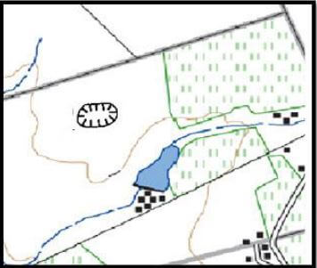
[Source: Extract of part of block H1 (scale 1 : 10 000)]
4.3.1 The GIS specialist decides to buffer the excavation so that water quality in the dam and river can be maintained.
- Define the term buffering. (1 x 1) (1)
- Create a 100 m buffer around the excavation. Use the above extract to display the buffer. (1 + 2) (3) [15]
TOTAL: 75