GEOGRAPHY PAPER 2 GRADE 12 QUESTIONS - 2018 SEPTEMBER PREPARATORY EXAM PAPERS AND MEMOS
Share via Whatsapp Join our WhatsApp Group Join our Telegram GroupGEOGRAPHY PAPER 2
GRADE 12
NATIONAL SENIOR CERTIFICATE
SEPTEMBER 2018
RESOURCE MATERIAL
- An extract from topographical map 2530BD MBOMBELA
- Orthophoto map 2530 BD 25 MBOMBELA
- NOTE: The resource material must be collected by schools for their own use.
INSTRUCTIONS AND INFORMATION
- Write your NAME and SURNAME in the space provided on the cover page.
- Answer ALL the questions in the spaces provided on this question paper.
- You are provided with a 1 : 50 000 topographic map (2530BD MBOMBELA) and an orthophoto map (2530 BD 25 MBOMBELA) of a part of the mapped area.
- You must hand in the topographic map and the orthophoto map to the invigilator at the end of this examination session.
- You must use the blank page at the back of this paper for all rough work and calculations. DO NOT detach this page from the question paper.
- Show ALL calculations and use supplied formulae, where applicable. Marks will be awarded for these.
- Indicate the correct unit of measurement in the final answer of calculations. No marks allocated for answers with incorrect units.
- You may use a non-programmable calculator and a magnifying glass.
- The area demarcated in RED on the topographic map represents the area covered by the orthophoto map.
- The following English terms and their Afrikaans translations are shown on the topographical map:
| ENGLISH | AFRIKAANS |
| Landing strip Furrow Caravan park Canal Sewerage works Golf course Excavation Nature reserve Rifle range Aerodrome Ravine | Landingstrook/Aanloopbaan Voor Karavaanpark Kanaal Rioolwerke Gholfbaan Uitgrawing Natuurreservaat Skietbaan Vliegveld Kloof |
| GENERAL INFORMATION ON 2530 BD MBOMBELA The city of Mbombela is situated in the eastern part of South Africa and is the capital of Mpumalanga Province. The city is built on the fertile, flat valley floor of the Crocodile River where there is ample water supply from the river. The city serves as a gateway to some of the best eco and adventure activities in Southern Africa and with its moderate climate it becomes a preferred tourist destination all year round. The sub-tropical fruits like mangos, avocados, oranges, lemons, lychees and bananas are grown in the surrounding Lowveld region. For shopping enthusiasts the city offers world-class shopping malls, casinos and entertainment venues and a convenient stopover to the Kruger Park. The location of Mbombela creates excellent opportunities for prospective investors and businesses to establish themselves in the area along the N4 transport route servicing the Maputo Spacial Development Corridor. 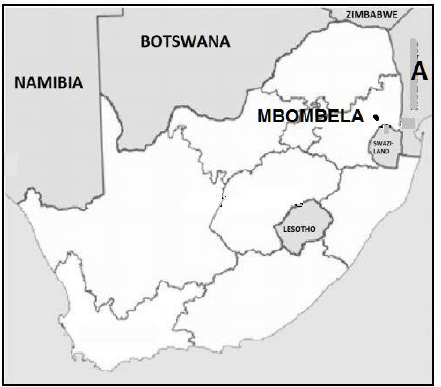 Coordinates: 25°27′57″S 30°59′07″E / 25°27,4′S 30°59,9′E |
QUESTION 1: MULTIPLE-CHOICE QUESTIONS
The questions below are based on the 1 : 50 000 topographical map 2530BD MBOMBELA, as well as the orthophoto map of a part of the mapped area. Various options are provided as possible answers to the following questions. Choose the answer and write only the letter (A–D) in the block next to each question.
1.1 The neighbouring country A on the general information map on page 3 is …
- Swaziland.
- Zimbabwe.
- Mpumalanga.
- Mozambique.
1.2 The map index/reference of the topographic map to the south-east of Mbombela is …
- 2530 DA.
- 2530 DB.
- 2530 DA.
- 2531 CA.
1.3 According to the urban hierarchy Mbombela is classified as a …
- city.
- minor country town.
- hamlet.
- metropolitan.
1.4 The N4 in blocks F3, F4 and F5 is found along a …
- plateau.
- watershed
- river valley.
- interfluve.
1.5 The feature 1 on the orthophoto map is a …
- recreational ground.
- research.
- show ground.
- sewerage works.
1.6 The true bearing of trigonometric station 111 (block G5) from spot height 1028 (block H5) is …
- 22°.
- 197°.
- 10°.
- 108°.
1.7 Feature B on the topographic map is a(n) …
- dam.
- cemetery.
- embankment.
- excavation.
1.8 The slopes found between 2 and 3 on the orthophoto map indicate a … slope.
- concaved
- terraced
- convexed
- steep
1.9 Feature 4 on the orthophoto map is a …
- shopping centre.
- factory.
- hospital.
- prison.
1.10 The man-made feature at 25°24'35"S 30°55'20"E on the topographic map is a …
- windmill.
- power sub-station.
- factory.
- trigonometric station.
1.11 The land-use zone numbered 5 on the orthophoto map is a …
- rural-urban fringe.
- high-income residential area.
- central business district.
- industrial area.
1.12 The orthophoto map is an example of a ... photograph.
- high-angle oblique
- low-angle oblique
- horizontal
- vertical aerial
1.13 The man-made feature at 6 on the orthophoto map is a/are …
- lighthouse.
- telephone lines.
- communication tower.
- power line.
1.14 When travelling in a southerly direction on the R40 from Mbombela, the next central place settlement will be ...
- Barberton.
- Komatipoort.
- Mataffin.
- Kaapmuiden.
1.15 The N4 passing Mbombela forms part of the … Spacial Development Corridor.
- Lebombo
- Wild Coast
- Maputo
- Phalaborwa
(15 x 1) (15)
[15]
QUESTION 2: MAPWORK CALCULATIONS AND TECHNIQUES
2.1 Locate the points 2 and 3 on the orthophoto map.
2.1.1
- Identify the indicator of height at 2.
(1 x 1) (1) - State the height at 2.
(1 x 1) (1)
2.1.2 Calculate the average gradient between point 2 and point 3 on the orthophoto map in metres.
Show ALL calculations. Marks will be awarded for calculations.
Formula: Gradient = Vertical interval (VI)
Horizontal equivalent (HE)
(5 x 1) (5)
2.1.3 Explain why your answer to QUESTION 2.1.2 indicates a gentle gradient.
(1 x 1) (1)
2.2 Using the information on the topographic map, determine the magnetic declination for 2018. Show ALL calculations. Marks will be awarded for calculations.
Difference in years:
Mean annual change:
Total change:
Magnetic declination for 2018:
(5 x 1) (5)
2.3 Refer to the demarcated area in RED on the topographic map, which represents the area covered by the orthophoto map.
2.3.1 Calculate the above area. Show ALL calculations. Marks will be awarded for calculations.
(5 x 1) (5)
2.4 Would the orthophoto map have a smaller or larger scale when compared to the topographic map? Give a reason for your answer.
Answer:
Explain:
(2 x 1) (2)
[20]
QUESTION 3: APPLICATION AND INTERPRETATION
3.1 Mbombela is situated alongside the Umgwenya River.
3.1.1 Name ONE physical feature that would hinder a canoeist (someone using a small canoe) going downstream between C and D on the topographical map.
(1 x 1) (1)
3.1.2 Give a reason for your answer in QUESTION 3.1.1.
(1 x 2) (2)
3.2 Refer to block H3, I3 and the sketch below.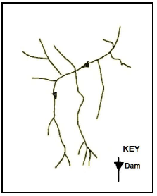
3.2.1 Name the stream pattern evident in this basin.
(1 x 1) (1)
3.2.2 State TWO characteristics of the stream pattern identified in QUESTION 3.2.1.
(2 x 1) (2)
3.2.3 Complete the table below to show the number of tributaries for each stream order.
| Stream order | 1 | 2 | 3 |
| Number of tributaries | 14 |
(2 x 1) (2)
3.2.4 Identify the type of river in this basin.
(1x 1) (1)
3.3 Refer to the Riverside Industrial Park labelled E (blocks F8, G8) on the topographic map.
3.3.1 What is an industrial park?
(1 x 1) (1)
3.3.2 What are the economic benefits of the Riverside Industrial Park for Mbombela and its location?
(2 x 2) (4)
3.4 Identify the following features labelled 7 and 8 on the orthophoto map.
7:
8:
(2 x 1) (2)
3.5 The original N4 indicated in blocks G8, H9 and H10 has been deviated (re-routed) to the north of Mbombela.
3.5.1 Explain why the N4 had to be deviated in order to go around the city.
(2 x 2) (4)
3.6 Refer to Mataffin residential area in block G6 on the topographic map.
3.6.1 Identify the street pattern of this land-use area.
(1 x 1) (1)
3.6.2 Discuss ONE advantage and ONE disadvantage of the street pattern identified in QUESTION 3.6.1.
Advantage:
(1 x 2) (2)
Disadvantage:
(1 x 2) (2)
[25]
QUESTION 4: GEOGRAPHICAL INFORMATION SYSTEMS (GIS)
4.1 The following is a freehand sketch map of the area covered by the topographic map in blocks A 8, 9, 10 / B 8, 9, 10 and C 8, 9, 10.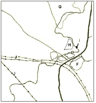
4.1.1 Identify the features H, I and J in the sketch as either a point, line or polygon.
H:
I:
J:
(3 x 1) (3)
4.1.2 Give ONE advantage of using vector data.
(1 x 2) (2)
4.1.3 Use the topographic map and identify the following features on the sketch map.
F:
G:
(2 x 1) (2)
4.1.4 State the spatial position of Curlew from Phumlani.
(1 x 1) (1)
4.2 Refer to blocks F5 and F6 on the topographic map. The local district municipality has decided to do an environmental impact study to evaluate the influence a rubbish dump would have on the area.
4.2.1 Mention ONE way in which data can be collected to do an environmental impact study.
(1 x 1) (1)
4.2.2 Identify TWO visible layers in block F6 that a GIS specialist would use to evaluate the suitability of the dump site.
(2 x 1) (2)
4.2.3 Give a reason for each of your answers in QUESTION 4.2.2.
(2 x 2) (4)
[15]
TOTAL: 75