GEOGRAPHY PAPER 2 GRADE 12 QUESTIONS - AMENDED SENIOR CERTIFICATE EXAMS PAST PAPERS AND MEMOS MAY/JUNE 2018
Share via Whatsapp Join our WhatsApp Group Join our Telegram GroupGEOGRAPHY
PAPER 2
GRADE 12
AMENDED SENIOR CERTIFICATE EXAMS
PAST PAPERS AND MEMOS
MAY/JUNE 2018
RESOURCE MATERIAL
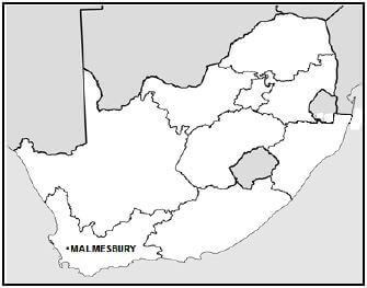
- An extract from topographic map 3318BC MALMESBURY.
- Orthophoto map 3318 BC 25 MALMESBURY.
- NOTE: The resource material must be collected by schools for their own use.
INSTRUCTIONS AND INFORMATION
- Write your EXAMINATION NUMBER and CENTRE NUMBER in the spaces provided on the cover page.
- Answer ALL the questions in the spaces provided in this question paper. You are provided with a 1 : 50 000 topographical map (3318BC
- MALMESBURY) and an orthophoto map (3318 BC 25 MALMESBURY) of a part of the mapped area.
- You must hand the topographic map and the orthophoto map to the invigilator at the end of this examination session.
- You may use the blank page at the end of this question paper for all rough work and calculations. Do NOT detach this page from the question paper.
- Show ALL calculations and formulae, where applicable. Marks will be allocated for these.
- Indicate the correct unit of measurement in the final answer for all calculations. No marks will be awarded for answers with no/incorrect units of measurement.
- You may use a non-programmable calculator and a magnifying glass.
- The area demarcated in RED on the topographic map represents the area covered by the orthophoto map.
- The following English terms and their Afrikaans translations are shown on the topographic map:
ENGLISH
Canal
Furrow
Golf Course
Prison
Refuse Dump
River
Sewerage Works
GENERAL INFORMATION ON MALMESBURY Malmesbury is a town of approximately 36 000 inhabitants, about 65 km north of Cape Town. The town has a moderate climate due to the influence of the Atlantic Ocean. Rainfall is seasonal, with the highest average rainfall being in winter. The area is especially known for its wheat farming and wine production.
[Source: http://en.wikipedia.org/wiki/malmesbury] |

QUESTIONS
QUESTION 1: MULTIPLE-CHOICE QUESTIONS
The questions below are based on the 1 : 50 000 topographic map (3318BC MALMESBURY) as well as the orthophoto map of a part of the mapped area. Various options are provided as possible answers to the following questions. Choose the answer and write only the letter (A–D) in the block next to each question.
1.1 The city situated approximately 65 km south of Malmesbury is …
- Paarl.
- Cape Town.
- Port Elizabeth.
- Klipheuwel.
1.2 In the map index of 3318BC, the 18 represents …
- 18° south of the equator.
- 18° west of the Greenwich Meridian.
- 18° north of the equator.
- 18° east of the Greenwich Meridian.
1.3 … aerial photographs are used to create the orthophoto map.
- Horizontal
- Satellite
- Vertical
- Oblique
1.4 The contour interval of the orthophoto map is … metres.
- 5
- 10
- 15
- 20
1.5 When you use the main road in block I11 on the topographic map to travel to Klipheuwel, you will be travelling in a … direction.
- east-south-easterly
- south-south-easterly
- west-north-westerly
- north-north-westerly
1.6 The source of water available for farming in block A1 on the topographic map is a …
- canal.
- windpump.
- river.
- dam.
1.7 The grid reference/co-ordinates for spot height 167 in block C6 on the topographic map is …
- 33°23'30''S 18°38'30''E/33°23,5'S 18°38,5'E.
- 18°38'30''E 33°23'30''S/18°38,5'E 33°23,5'S.
- 18°38'30''S 33°23'30''E/18°38,5'S 33°23,5'E.
- 33°23'30''E 18°38'30''S/33°23,5'S 18°38,5'S.
1.8 The land-use zone in which 5 on the orthophoto map is situated is the …
- commercial zone.
- residential zone.
- rural urban fringe.
- industrial zone.
1.9 The general flow direction of stream J in block D11 on the topographic map is …
- north.
- south.
- east.
- west.
1.10 The buildings at 1 on the orthophoto map is a …
- shop.
- prison.
- school.
- factory.
1.11 The recreational area 2 on the orthophoto map is a …
- caravan park.
- game reserve.
- golf course.
- botanical gardens.
1.12 The natural feature at line 3 on the orthophoto map is a …
- spur.
- gap.
- saddle.
- valley.
1.13 The street pattern at K in block G12 on the topographic map is …
- planned irregular.
- grid iron.
- unplanned irregular.
- radial.
1.14 The settlement demarcated at area L in blocks H8 and I8 on the topographic map is a …
- hamlet.
- city.
- town.
- village.
1.15 The main factor evident on the topographic map, that influenced the site of the settlement at M in block C2, is the …
- slope aspect.
- perennial water.
- fertile soil.
- pasturage.
(15 x 1) [15]
QUESTION 2: MAP CALCULATIONS AND TECHNIQUES
2.1 Products from Malmesbury are transported along the N7 national road to Cape Town.
2.1.1 Determine if vehicles travelling from Malmesbury to N in block I8 on the topographic map, will drive uphill or downhill. (1 x 1) (1)
2.1.2 Give a reason for your answer to QUESTION 2.1.1. (1 x 1) (1)
2.1.3 Calculate the distance, in km, from N in block I8 on the topographic map to Cape Town. Show ALL calculations. Marks will be awarded for calculations. Clearly indicate the unit of measurement in your final answer.
Formula: ActualDistance = Map Distance x Scale (4 x 1) (4)
2.2 Refer to line O-P that connects contour line 120 at O and spot height 162 at P in blocks I9 and I11 on the topographical map.
2.2.1 Draw a freehand cross-profile from O to P.
- Use the block below to draw the cross-profile.
- Use an arrow and indicate the accurate position of the other road on the cross-profile.
 (2 x 1) (2)
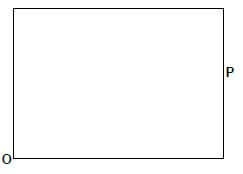 (2 x 1) (2)
 2.2.2 Give ONE reason why there is no intervisibility between O and P (1 x 1) (1)
2.2.3 If you use a vertical scale of 1 cm represents 25 m to draw the cross-profile, determine the vertical exaggeration of the cross profile. Show ALL calculations. Marks will be awarded for calculations. Clearly indicate the unit of measurement in your answer. (4 x 1) (4)
Formula: Vertical exaggeration = vertical scale
horizontal scale
2.3 Calculate the magnetic bearing on the topographic map, from the reservoir (Q) in block B5 to spot height 317 (R) in block D8 for the current year.
True bearing: __________________________________________________
Difference in years: _____________________________________________
Mean annual change: ___________________________________________
Total change: __________________________________________________
Magnetic declination for 2018: _____________________________________
Magnetic bearing for 2018: ________________________________________ (7 x 1) (7) [20]
QUESTION 3: APPLICATION AND INTERPRETATION
3.1 Malmesbury receives seasonal rainfall.
3.1.1 Name the season in which Malmesbury receives its highest rainfall. (1 x 1) (1)
3.1.2 Which weather system is responsible for Malmesbury receiving its highest rainfall in the season named in QUESTION 3.1.1? (1 x 1) (1)
3.1.3 Give ONE point of evidence from the topographic map which indicates that Malmesbury receives seasonal rainfall. (1 x 1) (1)
3.2 Refer to Abbotsdale, situated in blocks I7 and I8 on the valley floor, on the topographic map.
3.2.1 Is the local wind responsible for the cool conditions experienced in Abbotsdale at night time, an anabatic or katabatic wind? (1 x 1) (1)
3.2.2 Why does this local wind, named in QUESTION 3.2.1, result in a high concentration of pollution in Abbotsdale at night? (1 x 2) (2)
3.2.3 With specific reference to the topographic map, what can the Abbotsdale local government (municipality) do to reduce the high concentration of pollution? (1 x 2) (2)
3.3 Refer to area T on the topographic map. It shows a dendritic drainage pattern.
3.3.1 Give TWO characteristics, visible on the topographic map, which indicates that a dendritic drainage pattern is shown. (2 x 1) (2)
3.3.2 State a characteristic of the underlying rock structure associated with a dendritic drainage pattern. (1 x 1) (1)
3.3.3 With reference to area T, give the advantage of a dendritic drainage pattern for cultivation. (1 x 2) (2)
3.4 Malmesbury is a central place town according to its main function.
3.4.1 Give ONE reason visible on the topographic map to support the statement that Malmesbury is a central place. (1 x 2) (2)
3.4.2 Malmesbury experienced urban expansion, resulting in a change in the town's original shape.
- What is Malmesbury's visible shape on the topographic map. (1 x 1) (1)
- Give the main factor responsible for Malmesbury's current shape. (1 x 1) (1)
3.4.3 Which physical (natural) factor may limit the expansion of Malmesbury in a south-easterly direction into block H12? (1 x 2) (2)
3.5 Refer to area 4 on the orthophoto map.
3.5.1 Area 4 is being prepared for the planting of an agricultural product. Name the agricultural product that will be planted in area 4. (1 x 1) (1)
3.5.2 State the main secondary activity in Malmesbury associated with the agricultural product named in QUESTION 3.5.1. (1 x 1) (1)
3.5.3 Suggest how the secondary activity stated in QUESTION 3.5.2 can improve the local economy of Malmesbury. (2 x 2) (4) [25]
QUESTION 4: GEOGRAPHICAL INFORMATION SYSTEMS (GIS)
4.1 Refer to the orthophoto map.
4.1.1 State the difference between spatial and attribute data.
Spatial data: __________________________________________
Attribute data: _________________________________________ (2 x 1) (2)
4.1.2 The N7 national road is a tarred road. Would you consider this information to be spatial or attribute data? (1 x 1) (1)
4.1.3 Give a reason for your answer to QUESTION 4.1.2. (1 x 2) (2)
4.2 Refer to blocks C4, D3, D4 and D5 on the topographic map showing an example of buffering. (S points to areas of buffering.)
4.2.1 What is buffering? (1 x 1) (1)
4.2.2 Explain the positive impact that buffering will have on environmental sustainability in the area. (2 x 2) (4)
4.3 Refer to block C11 on the topographic map.
4.3.1 Define the term data integration. (1 x 1) (1)
4.3.2 Give examples of the following data layers found in block C11.
- An infrastructure layer: _____________________________ (1 x 1) (1)
- A drainage layer: _________________________________ (1 x 1) (1)
4.3.3 State the relationship between agricultural activities and the features of drainage layers in block C11. (1 x 2) (2)
[15]
GRAND TOTAL: 75