GEOGRAPHY PAPER 1 GRADE 12 MEMORANDUM - 2018 JUNE EXAM PAST PAPERS AND MEMOS
Share via Whatsapp Join our WhatsApp Group Join our Telegram GroupGEOGRAPHY PAPER 1
GRADE 12
NATIONAL SENIOR CERTIFICATE
MEMORANDUM
JUNE 2018
SECTION A:
PHYSICAL GEOGRAPHY – CLIMATE, WEATHER AND GEOMORPHOLOGY
QUESTION 1
1.1
1.1.1 B (1)
1.1.2 D (1)
1.1.3 G (1)
1.1.4 I (1)
1.1.5 E (1)
1.1.6 A (1)
1.1.7 H (1)
1.1.8 C (1)
(8 x 1) (8)
1.2
1.2.1 Deranged (1)
1.2.2 Trellis (1)
1.2.3 Centripetal (1)
1.2.4 Radial / Centrifugal (1)
1.2.5 Trellis (1)
1.2.6 Dendritic (1)
1.2.7 Parallel (1)
(7 x 1) (7)
1.3
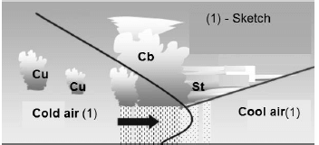
1.3.1 The cold front has caught up with the warm front (1)
The warm sector has become narrower (1)
Indication of the cold and warm front mixed (1)
[Any TWO] (2 x 1) (2)
1.3.2 Decrease in air temperature (1)
Strong winds (1)
Varies from light to heavy continuous rainfall/showers (1)
Lowest pressure is experienced (1)
Humidity will decrease (1)
[Any TWO] (2 x 1) (2)
1.3.3
- Cold front moves faster than the warm front (2)
Cold front overtakes warm front (2)
Cold air wedges in under the warm air, and lifts it up from the earth’s surface (2)
[Any TWO] (2 x 2) (4) 
(3 x 1) (3)- Before the occlusion, it will be fair to hazy (2)
During the passing over the visibility will be very poor (2)
Visibility will improve as the occlusion passes (2)
[Any TWO] (2 x 2) (4)
1.4
1.4.1 Refers to the climate of a small local area (1)
[Concept] (1 x 1) (1)
1.4.2 It is the south facing slope which is cooler because it receives oblique sun rays (1)
(1 x 1) (1)
1.4.3 Southern (1)
(1 x 1) (1)
1.4.4 North facing slope receives direct insolation (2)
(1 x 2) (2)
1.4.5 Dense vegetation such as forests, shrubs and ferns grow in the shadow zone because of the cool and moist conditions (2)
(1 x 2) (2)
1.4.6 Katabatic winds blow down the valley slope at night (2)
Mountain winds blow down the valley floor (2)
Temperature inversions occur on calm, clear and cold winter nights (2)
Frost pockets may form at the bottom of the valley if temperatures drop to below 0 °C in winter (2)
Radiation fog forms when air temperatures cool below dew point temperature (2)
[Any FOUR]
(4 x 2)(8)
1.5
1.5.1 A river that only flows in the rainy season (1)
[Concept] (1 x 1) (1)
1.5.2 Below the surface (1) (1 x 1)
1.5.3 Turbulent flow (1) (1 x 1)
1.5.4 Big boulders cause friction (2)
Rough river channel (2) (2 x 2) (4)
1.5.5 Periodic rivers
Will provide an irregular supply of water (2)
Forced into growing seasonal crops (2)
Reduced yields (2)
Increase the costs to obtain sufficient water (2)
If there is no proper planning, there will be a loss of income (2)
Poverty increases in areas where subsistence farming
dominates (2)
Lack of domestic water (2)
Food insecurity (2)
Loss of jobs as farming declines (2)
Irrigation schemes and building of dams will increase the costs of water supply (2)
[Any FOUR] (4 x 2) (8)
1.6
1.6.1 Network of river channels, separated by small sand islands (1) [Concept] (1 x 1)
1.6.2 Lower (1) (1 x 1)
1.6.3 Gentle/flat (1) (1 x 1)
1.6.4 Forces the river to split into channels (2) (1 x 2)
1.6.5 The river’s energy decreases, so does its capacity to transport the river load and so deposition occurs (2)
This occurs after flooding and the river will deposit its load in the channel (2)
This forces the river to flow around the deposited sediments (2)
These islands of deposition cause the river to braid resulting in a series of converging and diverging segments in the river course (2)
[Any THREE] (3 x 2)
(6)
1.6.6 Roads will be near impossible to construct (2)
No railway lines are possible (2)
Sand is very unstable for the building of bridges (2)
[Any TWO] (2 x 2) (4)
[75]
QUESTION 2
2.1.1 5̊ to 25̊ (1)
2.1.2 30–65 km (1)
2.1.3 east to west (1)
2.1.4 anti-clockwise (1)
2.1.5 mature (1)
2.1.6 divergence (1)
2.1.7 temperature (1)
(7 x 1) (7)
2.2
2.2.1 C (rejuvenation) (1)
2.2.2 B (captor) (1)
2.2.3 B (waterfall) (1)
2.2.4 D (wind gap) (1)
2.2.5 D (is uneven and has many obstacles) (1)
2.2.6 B (longitudinal) (1)
2.2.7 C (V-shaped valleys) (1)
2.2.8 D (little vegetation cover) (1)
(8 x 1) (8)
2.3
2.3.1 A (1) (1 x 1)
2.3.2 Inversion layer lower than the plateau (1) (1 x 1)
2.3.3
- Subsiding air from the Kalahari high heats up at the DALR and is warmer than the air from the coastal regions (1)
(1 x 1) (1) - During winter ITCZ moved northwards, resulting in less continental heating (2)
Subsiding air from the Kalahari high / Sub-tropical high is dominant, forcing the inversion below the escarpment (2)
In summer the ITCZ has moved southwards, resulting in more continental heating (2)
The convection streams over the interior cause the inversion layer to be lifted above the escarpment (2)
[Any THREE] (3 x 2)
(6) - A (Winter)
Very little moisture and rainfall, that may cause droughts (2)
Farmers need to irrigate much more to make the yield productive (2)
Dams may run dry or the levels will drop rapidly (2)
The production of agricultural activities decreases (2)
B (Summer)
Rainfall in the form of thunderstorms occur (2)
Heavy rainfall may cause soil erosion (2)
Flooding may occur which negatively influences farming activities (2)
Rainfall will fill up the dams (2)
The amount of rainfall will decrease the need for irrigation (2)
[BOTH SEASONS MUST BE DISCUSSED FOR FULL MARKS]
(3 x 2)(6)
2.4
2.4.1 A region of higher temperatures in an urban area with lower temperatures surrounding it (1)
[Concept] (1 x 1)(1)
2.4.2 Driving motor vehicles (1)
Tall buildings (1)
Air conditioners (1)
Road surfaces (1)
[Any TWO] (2 x 1) (2)
2.4.3 Heat stress may result in heart ailments (2)
Increased summer time energy demand (2)
Air conditioning use will increase and will have an effect on costs (2)
[Any TWO] (2 x 2)
(4)
2.4.4 Greenbelt
Vegetation lowers temperatures by providing shade, especially under tree canopies (2)
Plants decrease the production of greenhouse gas emissions, which in turn decreases temperatures (2)
Greenbelts increase evapotranspiration, which reduces air temperatures (2)
The process of photosynthesis absorbs solar heat (2)
Rivers
Water has a higher specific heat, and therefore takes longer to heat up (2)
Water absorbs heat, having a cooling effect on the area (2)
Breezes from the river, will reduce temperatures during the day (2)
[BOTH GREENBELT AND RIVERS MUST BE EXPLAINED FOR FULL MARKS] (4 x 2)
(8)
2.5
2.5.1 A drainage basin is an area drained by a river and its tributaries (1)
A catchment area refers to the upper reaches of a drainage basin which supplies a river with water (1)
[Concept] (2 x 1) (2)
2.5.2 Rainfall (1)
Groundwater (1)
(2 x 1) (2)
2.5.3 Amount/nature of precipitation (1)
Gradient (1)
Vegetation (1)
Soil condition/Geology (1)
[Any TWO] (2 x 1) (2)
2.5.4
- A high lying area that separates two different drainage basins (1)
[Concept] (1 x 1) (1) - It changes when the watershed is steeper on one side as compared to the other (2)
Rivers that flow down the steeper side erode the landscape faster, thus, changing the position of the watershed (2)
This process is referred to as abstraction (2)
[Any TWO] (2 x 2) (4) - The river flowing down the steeper side of the watershed will continue to erode headwards (2)
It will then divert the water of the river flowing on the less steeper side of the watershed into its channel (2) (2 x 2) (4)
2.6
2.6.1 To add harmful substances to our rivers / make our rivers dirty (1)
[Concept] (1 x 1) (1)
2.6.2 Domestic sewage (1)
Washing clothes (1)
Industrial waste (1)
Recreational activities (1)
Dumping (1)
[Any TWO] (2 x 1) (2)
2.6.3 Oxygen is reduced for plants and animals living in the water (2)
Water shortages (2)
Polluted water increases our exposure to health hazards (2)
Reduced quality of water due to increased pollution (2)
Decreases biodiversity (2)
Increases risk of flooding (2)
Negative for recreation/tourism (2)
[Any TWO] (2 x 2) (4)
2.6.4 Create buffer zones close to rivers (2)
Educate farmers on sustainable practices (2)
Fines to be imposed for dumping in rivers (2)
Encourage the growth of trees/vegetation (2)
Frequent testing of water quality (2)
Wetlands must be conserved (2)
Encourage recycling of waste as an alternative to dumping in our rivers (2)
Awareness campaigns (2)
[Any FOUR] (4 x 2)
(8)
[75]
SECTION B: RURAL AND URBAN SETTLEMENTS
QUESTION 3
3.1
3.1.1 Dispersed (1)
3.1.2 Dispersed (1)
3.1.3 Nucleated (1)
3.1.4 Nucleated (1)
3.1.5 Dispersed (1)
3.1.6 Nucleated (1)
3.1.7 Nucleated (1)
3.1.8 Nucleated (1)
(8 x 1) (8)
3.2
3.2.1 Top (1)
3.2.2 Small Town / Village (1)
3.2.3 Conurbation (1)
3.2.4 Megalopolis (1)
3.2.5 Large cities (1)
3.2.6 Town (1)
3.2.7 Hamlet (1)
(7 x 1) (7)
3.3
3.3.1 Movement of people from rural areas to urban areas (1)
[Concept] (1 x 1) (1)
3.3.2 Abandoned farming implements could suggest he lost his job (1) Few possessions could suggest poverty (1)
[Any ONE] (1 x 1) (1)
3.3.3 Buildings and farms have been abandoned (1) (1 x 1)
3.3.4 Lack of housing/informal settlements (2)
Crime (2)
Traffic congestion (2)
Insufficient services (2)
Uncontrollable waste management (2)
Overcrowding (2)
Breakdown of values, customs and traditions (2)
[Any TWO] (2 x 2)
(4)
3.3.5 Rural areas produce food (2)
Decrease in food production increases food prices (2)
Influences the GDP of the country (2)
Industries suffer from a lack of raw materials (2)
More unemployment (2)
Underutilised resources and services (2)
[Any FOUR]
(4 x 2) (8)
3.4
3.4.1 Water (1) (1 x 1)
3.4.2 Water is a basic need (1) (1 x 1)
3.4.3 Drought (1)
No rainfall for an extensive period (1)
[Any ONE] (1 x 1)(1)
3.4.4 There is no water in many areas of the rural town (2)
The town has run dry (2)
[Any ONE] (1 x 2) (2)
3.4.5 Theft and corruption (2)
Too expensive (R30 billion needed per year) (2)
(2 x 2) (4)
3.4.6 Decrease of employment opportunities (2)
Reduction in production leads to fewer workers needed (2)
Ripple effect on other industry’s employment, e.g. fewer drivers in transport (2)
Workers working less hours, with a decrease in salary and it has a negative effect on quality of life (2)
Services like financial institutions, schools, hospitals, etc. close (2)
[Any THREE] (3 x 2)
(6)
3.5
3.5.1
To explain location and relationship between different land-use zones in a city (2) (1 x 2)
3.5.2 B – Hoyt’s sector model (1)
C – Multiple nuclei model (1)
(2 x 1) (2)
3.5.3
- CBD (1) (1 x 1)
- In the centre for a high degree of accessibility (1)
Oldest part of the city/origin of city (1) (2 x 1) - Cities today have many nuclei (focal points) (2)
It is a more flexible model that resembles many cities in the developed world (2)
It shows the complex nature of cities considering factors that affect land-use zones (2)
Improved transport led to urban sprawl (2)
[Any TWO] (2 x 2)
(4)
3.5.4 They prevent uncontrolled growth of urban areas (2)
Lowers temperatures in the city (2)
Improves aesthetics of urban area (2)
Improve quality of air in urban areas (2)
[Any TWO] (2 x 2) (4)
3.6
3.6.1 An unplanned (illegal) settlement with no basic services provided (1)
[Concept] (1 x 1) (1)
3.6.2 The use of highly flammable energy (1)
Fuel sources that are not stored properly (1)
Close proximity of dwellings (1)
Highly flammable building material (1)
Use of illegal electricity connections (1)
[Any TWO] (2 x 1) (2)
3.6.3 Settlement has no proper infrastructure, for example roads (2)
Lack of planning (no street names) (2)
Roads are impassable (boulders and furrows) (2)
Lack of proper telecommunication services (2)
No proper water sources for fire emergency (2)
High crime-infested areas (2)
[Any TWO] (2 x 2)
(4)
3.6.4 SHORT TERM
Provision of tarred roads (2)
Provision of water points (2)
Electrification of area (2)
Regular refuse removal/prevents burning (2)
Private businesses to assist with food/blankets/clothes (2)
Erect temporary shelters (2)
Soup kitchens (2)
Consult community stake-holders (2)
LONG TERM
Provision of proper low-cost housing/RDP (2)
Provision of electricity in the form of solar panels (2)
Provision of proper infrastructure (2)
Build a community hall (2)
Job creation to increase standard of living (2)
Site and service facilities (2)
[Accept FOUR–MUST REFER TO BOTH ASPECTS]
(4 x 2) (8)
[75]
TOTAL: 225