GEOGRAPHY PAPER 2 GRADE 12 MEMORANDUM - 2018 JUNE EXAM PAST PAPERS AND MEMOS
Share via Whatsapp Join our WhatsApp Group Join our Telegram GroupGEOGRAPHY PAPER 2
GRADE 12
NATIONAL SENIOR CERTIFICATE
MEMORANDUM
JUNE 2018
QUESTION 1: MULTIPLE-CHOICE QUESTIONS
The questions below are based on the 1 : 50 000 topographic map (2930AC HOWICK) as well as the orthophoto map of a part of the mapped area. Various options are provided as possible answers to the following questions. Choose the answer and write only the letter (A–D) in the block next to each question.
1.1 The map reference of the orthophoto map south west of Howick is …
- 2930AC 25.
- 2930CA 4.
- 2930AC 24. ✓
- 2930CB 1.
1.2 The highest altitude between numbers 1 and 2 on the orthophoto is … metres.
- 987✓
- 985
- 970
- 982
1.3 The area covered by the orthophoto map on the topographic map is approximately … km2.
- 34,25
- 35,00
- 35,48✓
- 36,88
1.4 The settlement pattern C in block K6 on the topographic map is …
- clustered.
- dispersed.
- linear.✓
- circular.
1.5 The type of road D, in block H11 on the topographic map is a/an …
- main road.
- arterial road.
- other road.
- national freeway.✓
1.6 The channel pattern of Mgeni River between the areas 3 on the orthophoto map is … stream.
- deposition
- braided✓
- laminar
- delta
1.7 The approximate time the orthophoto was taken would be …
- 08:00–10:00.
- 10:00–12:00.✓
- 12:00–14:00.
- 15:00–17:00.
1.8 Kwa Mevana labelled 9 on the orthophoto map is located in/on a …
- spur.
- saddle.
- ridge.✓
- valley.
1.9 The province in which Howick town is located is …
- KwaZulu-Natal.✓
- Free State.
- Mpumalanga.
- Gauteng.
1.10 The true bearing of trigonometrical station 270 in block J13 from the letter E in block J13 on the topographic map is …
- 156˚.
- 241˚
- 120˚✓
- 102˚.
1.11 The location (co-ordinates) of the spot height 1495 in block J4 is …
- 29°28'36"E 30°02'42"S / 29°28,6'E 30°02,7'S.
- 29° 29'36"S 30°03'42"E / 29°28,6'S 30°03,7'E.
- 30°02'42"E 29°28'36"S / 30°02, 6’E 29°28, 36’S.
- D 29°28'36"S 30°02'37"E / 29°28,6'S 30°02,6'.✓
1.12 The natural feature at 4 on the orthophoto map is a …
- lake.
- waterfall.✓
- forest.
- dry pan.
1.13 The distance between F (block A4) and G (block A4) on the topographic map is … metres.
- 3,5
- 3 500
- 1,75
- 1 750✓
1.14 The feature 5 on the orthophoto is a/an …
- electric fence.
- hiking trail.
- pipe line.
- power line.✓
1.15 The contour interval on the orthophoto map is … metres.
- 2
- 5✓
- 10
- 20
(15 x 1)
[15]
QUESTION 2: MAPWORK CALCULATIONS AND TECHNIQUES
2.1 The scale of the topographic map is 1 : 50 000. Write down as a word scale.
1 cm on the map represents 50 000 centimetres in reality/on the actual ground. ✓
(Concept)
(1 x 1) (1)
2.2 Locate Tabankulu settlement (block E12) and spot height 1199 (block E14) on the topographic map.
2.2.1 What was the magnetic bearing of Tabankulu (block E12) from spot height 1199 (block E14) in 2016? Show ALL your calculations. Marks will be awarded for calculations.
Formula: ???????? ???????=???? ???????+???????? ???????????
True bearing = 285° ✓ (range 283° – 287°)
Difference in years: 2016 – 2002 = 14 ✓ years
Mean annual change: 12ʹ westwards ✓ (westwards must be indicated)
Total change: 12ʹ x 14 years = 162ʹ ✓ W (2° 48ʹW)
Magnetic declination for 2016: 22°54ʹ W + ✓2°48ʹ = 24°102ʹW
= 25° 42ʹW✓
Therefore: MB= 285° + 25° 42ʹ W
310°42ʹ W✓ (range 308° 42ʹ W – 312°42ʹ W)
(5 x 1) + (2) (7)
2.3 Locate points A (block I9) and B (block I10) on the topographic map.
2.3.1 Calculate the average gradient of the road between A and B on the topographic map.
Show ALL calculations. Marks will be awarded for calculations.
Formula:Gradient= ???????? ???????? (?.?)
?????????? ??????????? (?.?)
VI: (1110.3 – 1061.0) = 49,3 m✓
HE: 4,2 ✓ cm x 500 [Range for measurement 4,1 m – 4,3 m]
= 2 100 m ✓ [Range 2 050 m – 2 150]
Gradient = (??,?????)✓ [Give ONE mark for correct substitution]
G= 142.59 1 : 42,59 ✓ [Range: 1 : 41,58 – 1 : 43,61]
(5 x 1) (5)
2.3.2 With reference to the answer to QUESTION 2.3.1, is the gradient a true reflection of the actual landscape on which the road is built? Give a reason for your answer.
No. ✓
Reason:
The landscape undulates (there are large and small ups and downs)/when we calculate gradient, we are calculating mean (average) gradient. ✓
(2 x 1) (2)
2.3.3 Gradient is very important in planning road and railway construction. Is the gradient calculated in QUESTION 2.3.1 suitable for railway construction? Justify your answer.
Yes. ✓
Answer:
The calculated gradient is greater than 1 : 40 ✓
(2 x 1) (2)
2.4 Locate points 6 and 7 on the orthophoto map.
2.4.1 Draw a free-hand cross-section between points 6 and 7 on the orthophoto map.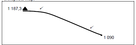
(NB: Marks should be allocated for the shape of the slope.)
(2 x 1) (2)
2.4.2 Why is it important to draw a cross-section? Give ONE reason.
Cross-sections provide a clever idea of the steepness or relief of an area. ✓
Cross-sections help in identifying/interpreting landforms. ✓
Cross-sections are useful for determining Indivisibility and gradient calculations. ✓
[Any ONE]
(1 x 1) (1)
[20]
QUESTION 3: APPLICATION AND INTERPRETATION
3.1 Refer to the area enclosed by the letter H (blocks E9/10) on the topographic map.
3.1.1 Identify the drainage pattern found in the area H (blocks E9/10).
Dendritic ✓
(1 x 1) (1)
3.1.2 Provide THREE map evidence to support the answer to
QUESTION 3.1.1.
Tributaries join the main rivers at an acute angle. ✓
The stream flows over uniform slopes (contour lines are uniformly spaced out). ✓
The stream is tree-like in appearance. ✓
(3 x 1) (3)
3.1.3 Determine the stream order of the stream enclosed within area H (blocks E9/10) on the topographic map.
2nd order stream ✓✓
(1 x 2) (2)
3.1.4 Is the stream within the area H (blocks E9/10) flowing in the northerly or southerly direction? Give TWO map evidence visible within blocks E9/10 and F10 to support your answer.
Southerly direction. ✓
Spot height values decrease downstream (1323 in block E9) and 1205 in block F10). ✓✓
Dam walls are located to the south. ✓✓
Tributaries join v-shaped in the southern direction. ✓✓
[Any TWO]
(1 + 2 x 2) (5)
3.2 Refer to both the topographic map and orthophoto map.
3.2.1 Identify land-use at 8 on the orthophoto map.
Cultivated land/crop farming ✓
(1 x 1) (1)
3.2.2 Was the orthophoto taken in early summer or middle summer? Use the tone of land-use 8 to motivate your answer.
Season: middle summer ✓
Motivation:
The crops in land-use 8 have a darker colour signifying a full growth season. ✓✓
(1 + 1 x 2) (3)
3.3 Refer to the Lions River (block H2).
3.3.1 Is the Lions River a graded or ungraded stream?
Ungraded ✓
(1 x 1) (1)
3.3.2 Give ONE piece of evidence from the topographic map to justify your answer to QUESTION 3.3.1
There is a waterfall/knick-point in the upper course of the Lions River. ✓✓
(1 x 2) (2)
3.4 Locate the residential area 9 on the orthophoto map.
3.4.1 Is the residential area labelled 9 on the orthophoto map a high-income or low-income residential area?
Low-income ✓
(1 x 1) (1)
3.4.2 Give TWO pieces of evidence from the orthophoto map to support the answer to QUESTION 3.4.1
Housing units/plots are relatively small ✓✓
Near industrial area ✓✓
Few greenbelts/recreational areas ✓✓ [ANY TWO]
(2 x 2) (4)
3.5 Locate the dams in block A9 on the topographic map.
3.5.1 What do these dams tell you about rainfall in the area?
It shows that rainfall is seasonal/insufficient. ✓✓
(1 x 2) (2)
[25]
QUESTION 4: GEOGRAPHICAL INFORMATION SYSTEMS (GIS).
4.1 Spatial data is stored in two different formats, namely vector and raster data.
4.1.1 Distinguish between vector and raster data.
Vector: Data stored in the form of lines, points and polygons
[Concept] ✓
Raster: Data stored in pixels / pictures ✓ [Concept]
(2 x 1) (2)
4.1.2 Is the topographic map of Howick in a vector or raster data format?
Vector ✓
(1 x 1) (1)
4.1.3 Provide ONE reason for your answer to QUESTION 4.1.2.
Spatial data is represented as lines, points and polygons ✓
(1 x 1) (1)
4.2 Find the railway line in block I7 on the topographic map. Give ONE attribute of the railway line.
The railway line has underground tunnels. ✓
Single track. ✓
Railway line along flat / gentle slope. ✓
[Any ONE]
(1 x 1) (1)
4.3 The topographic map extract below shows a buffer zone that is in block K10.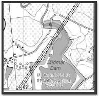
4.3.1 What is a buffer zone?
Boundary demarcating a geographical feature ✓
(1 x 1) (1)
4.3.2 With reference to the map extract, explain why this specific buffer zone was created.
Nature resort ✓✓
Public resort ✓✓
Conservation area ✓✓
Midmar Dam ✓✓ [Any TWO]
(2 x 2) (4)
4.4 A local businessman wants to open a food outlet in Kwa Mevana (block K14).
4.4.1 Mention TWO possible sets of data/information that the local businessman needs to retrieve (obtain) from the database to determine whether it would be profitable to set up his food outlet at Kwa Mevana.
The proximity of similar shops in the area ✓✓
Income levels of local population ✓✓
Population demographics / size ✓✓
Accessibility ✓✓
Crime levels ✓✓
Availability of open land ✓✓ [Any TWO]
(2 x 2) (4)
4.4.2 Why is it important that the local businessman queries the data retrieved from the database?
To ensure that data is accurate/reliable. ✓
(1 x 1) (1)
[15]
TOTAL: 75