GEOGRAPHY PAPER 1 GRADE 12 MEMORANDUM - 2018 SEPTEMBER PREPARATORY EXAM PAPERS AND MEMOS
Share via Whatsapp Join our WhatsApp Group Join our Telegram GroupGEOGRAPHY PAPER 1
GRADE 12
NATIONAL SENIOR CERTIFICATE
MEMORANDUM
SEPTEMBER 2018
SECTION A: CLIMATE, WEATHER AND GEOMORPHOLOGY
QUESTION 1
1.1
1.1.1 B (1)
1.1.2 A (1)
1.1.3 B (1)
1.1.4 B (1)
1.1.5 A (1)
1.1.6 B (1)
1.1.7 A (1)
(7 x 1) (7)
1.2
1.2.1 Easterly (1)
1.2.2 Water table (1)
1.2.3 Evapotranspiration (1)
1.2.4 Laminar (1)
1.2.5 Confluence (1)
1.2.6 Sheet (1)
1.2.7 Infiltration (1)
1.2.8 Interfluve (1)
(8 x 1) (8)
1.3
1.3.1 Summer (1)
(1 x 1) (1)
1.3.2 Moisture front (1)
(1 x 1)(1 )
1.3.3 Cold air originates from the anticlockwise movement of the South Atlantic High, blowing over the cold Benguela current (2)
The warm air comes from the anticlockwise movement of the south Indian high, blowing over the warm Mozambique current (2)
(2 x 2) (4)
1.3.4
- East side – south east (1)
West side – north west (1) (2 x 1) (2) - The clockwise movement of air from the low pressure over the interior during summer (2) (1 x 2) (2)
1.3.5 Heavy rainfall may cause bridges to collapse (2)
Railway lines and roads will be damaged (2)
Power outages will occur as powerlines are destroyed (2) (3 x 2) (6)
1.4
1.4.1 South facing (1) (1 x 1) (1)
1.4.2 The warmer middle slope in the valley receiving direct sunrays (1)
(CONCEPT) (1 x 1) (1)
1.4.3 The house is situated in the thermal belt, with higher temperatures throughout the year (2)
The pond (water) has a moderating influence on the temperature range (2)
(2 x 2) (4)
1.4.4 Reasons for difference in temperature
At A, the sunrays are more direct, and a small area is being heated (2)
At B, the slanted sunrays are heating a much larger area (2)
Influence of temperature difference on vegetation
At A, there will be less vegetation because it will be drier due to a higher evaporation rate (2)
Crops that are not frost resistant will be planted at A eg. apples, pears (2)
Frost resistant crops can be planted at B eg. tubers, citrus fruits (2)
(THE CONTRAST IN TEMPERATURE AND VEGETATION MUST BE MENTIONED FOR FULL MARKS)
(4 x 2) (8)
1.5
1.5.1 Floodplain (1) (1 x 1) (1)
1.5.2 Lower course (1) (1 x 1) (1)
1.5.3 Meander loop (1) (1 x 1) (1)
1.5.4 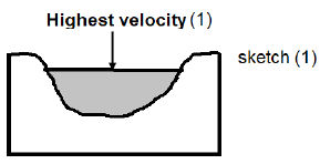
(2 x 1) (2)
1.5.5
- Cut-off from mainstream (1)
It has a horseshoe like shape (1)
There is still water in the horseshoe shape (1)
(Any TWO) (2 x 1) (2) - Cut off
Continuous undercutting at both outer banks at the neck (2)
River cuts through the neck during flooding (2)
Deposition of sand and silt isolate the oxbow lake from the mainstream (2)
Water supply
Frequent flooding causing the mainstream to overflow (2)
Rainfall keeps channel refreshed (2)
Groundwater through throughflow (2) (Any FOUR) (4 x 2) (8)
1.6
1.6.1 Headward erosion (1 x 1) (1)
1.6.2 Eastwards/East (1) (1 x 1) (1)
1.6.3 Rivers on the western side erode more rapidly than those on the eastern side (1) (1 x 1) (1)
1.6.4 River capture has increased the drainage density on the west side and decreased it on the east side (2) (1 x 2) (2)
1.6.5
- Y Wind gap (1)
Z Elbow of capture (1) (2 x 1) (2) - The area has become dry and consists of river gravel (2)
The stream in the valley has become misfit because the valley
it flows in is too large (2) (2 x 2) (4) - The generation of hydroelectricity will be possible (2)
It will become a tourist attraction, especially eco-tourism (2)
Water can be used for irrigation purposes (2)
(Any TWO) (2 x 2) (4)
[75]
QUESTION 2
2.1
2.1.1 outside (1)
2.1.2 Coriolis (1)
2.1.3 cirrus (1)
2.1.4 low (1)
2.1.5 eye (1)
2.1.6 Ann (1)
2.1.7 evaporation (1)
2.1.8 westward (1)
(8 x 1) (8)
2.2
2.2.1 Rectangular (1)
2.2.2 Dendritic (1)
2.2.3 Trellis (1)
2.2.4 Rectangular (1)
2.2.5 Trellis (1)
2.2.6 Dendritic (1)
2.2.7 Trellis (1)
(7 x 1) (7)
2.3
2.3.1 It is a weather system with high atmospheric pressure at its centre, around which airflow circulates anticlockwise (1) (1 x 1) (1)
2.3.2 South Atlantic high (1) (1 x 1) (1)
2.3.3 Sub-tropical high pressure belt (1) (1 x 1) (1)
2.3.4 During summer it is situated further south because of the southward migration of the ITCZ (2)
During winter the ITCZ moved northwards, hence the northly location of the high pressure system (2)
(2 x 2) (4)
2.3.5 Summer
Weather systems like mid-latitude cyclones cannot reach B, because the high pressure blocks the movement (2)
Less rainfall in area B (2)
Weaker pressure gradient will result in weaker wind speeds (2)
Onshore wind will have a cooling effect on the temperatures at B (2)
Winter
Mid-latitude cyclones can reach B, with cold front conditions dominating (2)
Increased rainfall, with heavy clouds will occur (2)
Strong winds will prevail (2)
Generally, the temperatures will be low (2)
(Any FOUR – BOTH SEASONS MUST BE MENTIONED)
(4 x 2) (8)
2.4
2.4.1 Urban heat island (1) (1 x 1) (1)
2.4.2
- A (1) (1 x 1)(1)
- Area A is in the centre of the urban area (2) (1 x 2) (2)
2.4.3 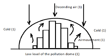
(Any THREE LABELS with correct illustration) (3 x 1) (3)
2.4.4 Rural areas area cooler, with the air pressure being higher and air moves from a high pressure to a low pressure (2) (1 x 2) (2)
2.4.5
- The temperature boundary of the rural area is lower than the temperature boundary of the urban area (2) (1 x 2) (2)
- Temperatures are higher in urban areas due to:
Artificial production of heat such as heating activities being more (2)
Artificial surfaces absorbing more heat (2)
The morphology of the city causing heat to be trapped between higher buildings (2)
Drainage systems channelling water away from the build-up area, so less insolation is used for the evaporation process (2)
(NOTE: Examples with explanation of each process can be given – The opposite about the rural areas can also be accepted)
(Any TWO) (2 x 2) (4)
2.5
2.5.1 The side view of a river from source to mouth (1)
[CONCEPT] (1 x 1) (1)
2.5.2 Rapids (1)
Waterfalls (1)
V-shaped valleys (1)
(Any TWO) (2 x 1) (2)
2.5.3 The river does not have a smooth, concave slope (2)
There are a lot of knickpoints, resulting in excessive erosion (2)
Erosion is the dominant process (2)
(Any ONE) (1 x 2) (2)
2.5.4
- The river in the lower course is deeper than the river in the upper course (2) (1 x 2) (2)
- The river in the middle course is wide due to lateral erosion (2)
The river in the upper course is narrow due to downward/ vertical erosion (2) (2 x 2) (4) - In the lower course the river channel does not have a lot of obstacles which can retard speed (2)
Laminar flow is dominant in the lower course (2)
The stream load in the lower course consists of very small particles to carry (2) (Any TWO) (2 x 2) (4)
2.6
2.6.1 When all people do not have access to clean fresh water (1)
(CONCEPT) (1 x 1) (1)
2.6.2 Industrial activities (1)
Agricultural activities (1)
Suburban waste/Urban dumping (1)
(Any TWO) (2 x 1) (2)
2.6.3 Ground water can be extracted during long periods of drought (2)
It can supplement water resources when industrial development and population growth occurs (2)
Industrial development, agricultural activities and waste from settlements are great sources of pollution and should be monitored and managed (2)
(Any TWO) (2 x 2) (4)
2.6.4 Agricultural area
Pesticides used in agriculture eventually end up in the Bay area, which contaminates water and kills fish (2)
Animal waste can lead to eutrophication and damage the Bay ecosystem (2)
Animal waste may introduce faecal coliform which threatens the health of fishermen and kills fish (2)
Overgrazing will increase soil erosion, which will raise the sediment input in the Bay area (2)
Industrial area
Industrial waste water increases eutrophication, which reduces oxygen for fish (2)
Industrial waste increases the murkiness of water, which in turn prevents sunlight from reaching plants and influences photosynthesis (2)
Outlet of waste water from industries can contaminate the water in the Bay and subsequently kill fish (2)
Industrial waste water increases the acidity levels of the Bay, that will negatively impact human activities like fishing and tourism (2)
Suburban waste/Urban dumping
Discarded fishing nets may cause ensnaring (tangling) fish and mammals (2)
Solid waste like bags, foam, plastic, etc. is often mistaken by fish as food (2)
Dumping will cause fish numbers to decrease, with a decline in fish production (2)
[Any FOUR – TWO ACTIVITIES MUST BE EXPLAINED] (4 x 2) (8)
[75]
QUESTION 3
3.1
3.1.1 Rural-Urban migration (1)
3.1.2 Less spending (1)
3.1.3 Ghost town develops (1)
3.1.4 Old people remain (1)
3.1.5 Population declines (1)
3.1.6 Bad roads (1)
3.1.7 Shops closed (1)
3.1.8 Infertile soil (1)
(8 x 1) (8)
3.2
3.2.1 Spatial Development Initiatives (1)
3.2.2 Industrial Development Zone (1)
3.2.3 Growth points (1)
3.2.4 Reconstruction and Development Program (1)
3.2.5 Centralisation (1)
3.2.6 Deconcentration points (1)
3.2.7 Maputo corridor (1)
(7 x 1) (7)
3.3
3.3.1 Stellar/star shaped (1) (1 x 1) (1)
3.3.2 The built-up areas developed a long road spiralling in different directions (2) (1 x 2) (2)
3.3.3 Buildings are near to one another (1) primary activities dominate (1) (2 x 1) (2)
3.3.4 Relief
Built-up area has developed on level/flat land (2)
The built-up area has developed between high lying areas (2)
Water
Settlement is a dry-point settlement, which is a distance away from the danger of flooding (2) (2 x 2) (4)
3.3.5 Flooding will damage the crops with a reduction in production (2)
Reduced production will negatively influence employment availability (2)
Decreased production will lead to fewer exports, thus revenue decreasing (2)
Flooding may cause infrastructure damage, with high repair costs (2)
Pricing of products may increase and negatively influence quality of life (2)
Businesses that depend on agriculture may close (2)
(Any THREE) (3 x 2) (6)
3.4
3.4.1 When a previously functioning city, zone or area falls into disrepair (1)
(CONCEPT) (1 x 1) (1)
3.4.2 Dilapidated buildings (1)
Environmental pollution (1)
High unemployment rate (1)
(Any TWO) (2 x 1) (2)
3.4.3
Decentralisation of businesses and industries left buildings empty and unattended (2)
No municipal services because of lack of payment by residents for these services (2)
Increase of migrants into the area put a lot of pressure on infrastructure like housing, which leads to overcrowding (2)
Rural-urban migration (2)
Increased unemployment which leads to poverty (2)
(Any TWO)
(2 x 2) (4)
3.4.4 Higher income adults move into the area (2)
Dilapidated buildings will be restored and maintained (2)
Municipal services will be paid, therefore services like water, electricity, waste removal, sanitation, etc. will be provided (2)
Policing in the area will increase, which will decrease crime and vandalism (2)
Higher income improves the buying power of the area and this will attract investors and businesses (2)
(Any FOUR)
(4 x 2) (8)
3.5
3.5.1 It involves the extraction of resources from nature (1)
(CONCEPT) (1 x 1) (1)
3.5.2 Lowest – October 2012 (1)
Highest – March 2015 (1) (2 x 1) (2)
3.5.3
- From March to June 2016 there is an increase (1)
Then a decrease from June 2016 to December 2016 (1)
An increase from December 2016 to March 2017 (1)
(Any TWO)
(2 x 1) (2) - This is to maintain the same monetary output when exporting (2)
(1 x 2) (2) - Climatic conditions (2)
Strikes in the mining sector (2)
Interrupted water and electricity supply (2)
(Any TWO) (2 x 2) (4)
3.5.4 A lot of unskilled labour results in lower labour wages (2)
Semi-skilled and skilled labourers reduce maintenance costs of equipment (2)
Highly skilled labour force improves the quality of beneficiation, with higher price value of products (2)
(Any TWO)
(2 x 2) (4)
3.6
3.6.1 Growth, Employment and Redistribution (1) (1 x 1) (1)
3.6.2 Privatisation (1)
Removal of exchange controls (1) (2 x 1) (2)
3.6.3 During apartheid only the minority gained from economic profits and policies (2)
There was a high number of unemployment amongst most non-whites in South Africa (2)
Most South Africans had a lack of basic services and facilities
(Any TWO) (2 x 2) (4)
3.6.4 Goals
Reducing of fiscal deficits (2)
Lowering inflation (2)
Maintaining exchange rate stability (2)
Liberalising capital flow (2)
Failures
Job creation was poor (2)
Very low GDP growth (2)
Very little private investment (2)
It did not bring about a reduction in poverty (2)
(Any FOUR – BOTH GOALS AND FAILURES MUST BE MENTIONED)
(4 x 2) (8)
[75]
QUESTION 4
4.1
4.1.1 (C) Neighbourhood shopping centre (1)
4.1.2 (E) Informal traders (1)
4.1.3 (G) Planned regional shopping centre (1)
4.1.4 (A) Outlying business district (1)
4.1.5 (F) Commercial ribbon development (1)
4.1.6 (H) Central business district (1)
4.1.7 (B) Isolated shops (1)
(7 x 1) (7)
4.2
4.2.1 GDP (1)
4.2.2 Extensive (1)
4.2.3 Economy (1)
4.2.4 Home (1)
4.2.5 Market (1)
4.2.6 Small (1)
4.2.7 Break-of-bulk (1)
4.2.8 Economically active (1)
(8 x 1) (8)
4.3
4.3.1 A third of South Africa’s population (1) (1 x 1) (1)
4.3.2 To create an opportunity for each person to create a sufficient material foundation upon which to have a dignified, productive, and creative life beyond economics
(CONCEPT) (1 x 1) (1)
4.3.3
They are excluded from the formal economy (1)
Denied the proceeds of profitable agriculture (1)
Denied the proceeds of mineral resources (1)
(Any TWO) (2 x 1) (2)
4.3.4 Land redistribution (1)
The government buys land from its owners and distributes it to previously disadvantaged people (2)
OR
Land tenure (1)
When people’s right to own and control it is recognised (2)
OR
Land restitution (1)
Government compensates (monetary) those individuals who were forcefully removed from their land (2)
(Any ONE POLICY WITH EXPLANATION) (1 + 2) (3)
4.3.5 Aids those individuals to own land that otherwise would have been impossible (2)
Redistribution of land would make it possible for those previously disadvantaged farmers to produce crops of their own (2)
Farmers who own land, would make sure that it is profitable, which will increase self-worth and standard of living (2)
Poor people will be able to afford basic services like housing (2)
People’s education levels will increase as skills have to be upgraded (2)
More secured employment will be available (2)
Will improve the food security of poor families (2)
(Any FOUR)
(4 x 2) (8)
4.4
4.4.1 It is the side view of the city, showing the different heights and zones in urban areas (1)
(CONCEPT) (1 x 1) (1)
4.4.2 Different zones can be clearly identified, which makes future planning easier (2)
Different land uses can be easily identified (2)
Open spaces and greenbelt areas can be included in new developments and construction (2)
(Any TWO) (2 x 2) (4)
4.4.3
- The physical expansion of urban areas (1) (1 x 1) (1)
- Rural-urban fringe (1) (1 x 1)(1)
- Increased pollution (air, water, environmental) (2)
The biodiversity will be lost and destroyed (2)
Ecosystem disturbed, and natural habitats destroyed (2)
The water cycle will be changed (2)
Temperature increases (2)
(Any TWO) (2 x 2) (4)
4.4.4 More employment opportunities occur (2)
People can afford larger houses as the land is much cheaper because expansion is into the rural-urban fringe (2)
Standard of living generally increases as the average income of families increases (2)
(Any TWO) (2 x 2) (4)
4.5
4.5.1 Manufacturing is the process of converting raw material into finished goods that meet the customers’ requirements (1) (1 x 1) (1)
4.5.2 Loss of 500 000 jobs (1) (1 x 1) (1)
4.5.3 High energy costs (1)
High labour costs (1)
Lagging infrastructure (1)
Policy and regulatory uncertainties (1)
Export of unbeneficiated goods (2)
Reliance on imports (1) (Any TWO) (2 x 1) (2)
4.5.4 Fewer manufactured goods lead to a decrease in revenue (2)
Prices of products increase, making it unaffordable for locals (2)
Fewer exports as the prices of manufactured commodities is not internationally competitive (2) (2 x 2) (4)
4.5.5 The value of the raw material is locally increased (2)
Higher foreign exchange, which leads to expansion of manufactured products (2)
Multiplier effect on other industries like transport, construction, improving infrastructure, etc. (2)
Beneficiation will lower imports as some of the imported products are replaced by self-manufacturing (2)
The skills and knowledge of locals will increase, with a positive future output in manufacturing (2)
More employment opportunities will be created (2)
(Any FOUR) (4 x 2) (8)
4.6
4.6.1 Western Cape (1) (1 x 1) (1)
4.6.2 Secondary activity: Mineral beneficiation (1)
Tertiary activity: Tourism (1)
Infrastructure (1)
(Any ONE) (2 x 1) (2)
4.6.3 Availability and distribution of products will be easier and quicker due to improved road and rail infrastructure (2)
The electricity supply will be constant without any interruptions and will not hamper production (2)
Port upgrades will increase import and export efficiency (2) (3 x 2) (6)
4.6.4
- Saldanha Bay is the only dedicated iron ore export harbour in South Africa (1) (1 x 1) (1)
- Marine and land ecosystems will be destroyed due to increased toxic waste and expansion of the industry (2)
Marine and land biodiversity will be destroyed due to increased toxic waste and expansion of the industry (2)
Groundwater will be contaminated and will negatively influence the water quality in the area (2)
Air pollution and possible acid rain will increase because of increased burning processes (2)
(Any TWO) (2 x 2) (4)
[75]
GRAND TOTAL: 225