Tuesday, 24 August 2021 07:18

RURAL SETTLEMENT AND URBAN SETTLEMENT QUESTIONS AND ANSWERS GRADE 12

Share via Whatsapp Join our WhatsApp Group Join our Telegram Group

Activity 3.1
Complete the table to illustrate your understanding of the classification of settlements as either rural or urban.

  Rural  Urban 
Function (activity)  (1 × 2 = 2)  (1 × 2 = 2)
Size and complexity
(smallest to largest settlements) 
(3) (5)

[12]

Answers to activity 3.1

  Rural  Urban 
Function (activity)  Unifunctional
(primary activities) (2)
Multifunctional
(secondary and tertiary activities)(2)
Size and complexity
(smallest to largest settlements) 
Farmstead, hamlet and village(3) Town, city, metropolis,conurbation,
megalopolis (5)

[12]

Activity 3.2
Study the two rural settlement diagrams in Figures 3.2.1B and 3.2.1C and complete the table.
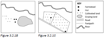
5

  Figure 3.2.2B  Figure 3.2.2C 
Function   (1 × 2 = 2)  (1 × 2 = 2)
Settlement pattern   (1 × 2 = 2)  (1 × 2 = 2)
Factors affecting the site   (1 × 2 = 2)  (1 × 2 = 2)
Factors affecting the situation   (1 × 2 = 2)  (1 × 2 = 2)

[16]

Answers to activity 3.2

  Figure 3.2.2B  Figure 3.2.2C 
Function  Rural/unifunctional (2) Rural/unifunctional (2) 
Settlement pattern  Nucleated (2) Dispersed/isolated(2) 
Factors affecting the site  Arable land
Drinking water
(any 1) (2) 
Arable land
Drinking water
Grazing land 
(any 1) (2)
Factors affecting the situation  Away from water
Dry point settlement
(any 1) (2)
Away from water
Dry point settlement
Near a road for transport
(any 1) (2)

[16]

Activity 3.3

  1. Expand the blank diagram in Figure 3.3.2A below and use the following terms to add a key to the diagram:
    1. Threshold population (1 × 2 = 2)
    2. Range (1 × 2 = 2)
    3. Sphere of influence (1 × 2 = 2)
      16
  2. Write definitions to show your understanding of the terms in a), b) and c). (3 × 2 = 6)
    [12]

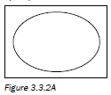
Apply what you have learnt about central places by completing activity 3.3.

Answers to activity 3.3

  1. 17
  2.  
    1. The minimum number of people needed to maintain a settlement or function (2)
    2. The maximum distance people are prepared to travel to a settlement or a function (2)
    3. The maximum area served by a settlement or function (2)
      [12] 

Activity 3.4

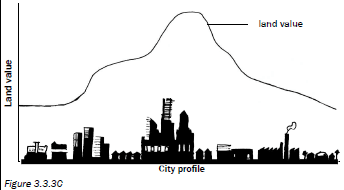
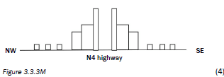
  1. On the urban profile shown in Figure 3.3.3B on page 56 draw a line graph to show how land value changes as you move towards the CBD. (1 × 2 = 2)
  2. How does building density change as you move towards the centre of the city? (1 × 2 = 2)
  3. Explain your answer in question 2. (2 × 2 = 4)
  4. Why would an office park move away from the Central Business District? (2 × 2 = 4)
    [12]

Apply your understanding of urban profiles by completing Activity 3.4.

Answers to activity 3.4

  1. 20
  2. The density of the buildings increases.  (2)
  3. The land is very expensive in the CBD so many buildings are built closer together and on smaller pieces of land. (4)
  4. Land value is cheaper /There is less traffic congestion / It is closer to clients /There is less noise /There is more parking(any 2) (4)
    [12] 

Activity 3.5
This activity is a mapwork interpretation of a settlement. Refer to the topographic map 2530BD Nelspruit and the orthophoto map extract at the back of this study guide and answer the following questions.

  1. Nelspruit/Mbombela is the capital of which South African province? (1 × 2 = 2)
  2.  
    1. What factors influenced the site of Nelspruit/ Mbombela? (4 × 2 = 8)
    2. Discuss the situation of Nelspruit/Mbombela. (3 × 2 = 6)
  3.  
    1. Identify the settlement pattern in block C2. Give a reason to support your answer. (2 × 2 = 4)
    2. What is the shape of the settlement in block B3? Why do you think it has taken this shape? (2 × 2 = 4)
  4. Classify the type of farming in block C3 as fully as possible, explaining your answer. (3 × 2 = 6)
  5.  
    1. What is different about the farm Friedenheim in block C5? (1 × 2 = 2)
    2. How could this farm help to prevent rural–urban migration? (1 × 2 = 2)
  6. What type of city would Nelspruit/Mbombela be classified as? Explain your answer. (2 × 2 = 4)
  7.  
    1. Give the block reference of the land use zone known as the CBD. (1 × 2 = 2)
    2. Draw a simple cross section sketch to illustrate the urban profile of the land use zone in question a). (2 × 2 = 4)
    3. What type of street pattern is found in this zone?
      Give two advantages and two disadvantages for this street pattern. (5 × 2 = 10)
  8. West Acres is an example of an upper income residential area. Give two reasons from the map to support this statement. (2 × 2 = 4)

    Study the orthophoto at the back of the study guide.
  9. What land use is found at A, B, C and D? (4 × 2 = 8)
  10. The residents of West Acres do not like travelling to the centre of Nelspruit/Mbombela to do their shopping as it has become so congested. Where would you suggest that they build a new shopping mall? Explain why you have chosen this site to build on. (3 × 2 = 6)
    [70]

Related Items

Answers to activity 3.5

  1. Nelspruit/Mbombela is the capital of Mpumalanga province. (2)
  2.  
    1. Analysis of the site of Nelspruit/Mbombela:
      • Near water from the river
      • Arable land from the river valley
      • Possible building material from the surrounding hills
      • Possible fuel from the vegetation on the slopes (8)
    2. Discussion of the situation of Nelspruit/Mbombela:
      1. Topography: It is on the valley floor so easy to establish/ Gap city between the mountains
      2. Gradient: The city is built on flat land for the large buildings/Residential areas are more on the slopes
      3. River: Buildings on the inner bank away from possible flooding
      4. Transport: On the main road to Mozambique on N4/ Links to the west–east and north–south/Part of Maputo Corridor (any 3 facts) (6)
  3.  
    1. Block C2 is a nucleated settlement pattern. The buildings are close to one another. (4)
    2. The settlement in block B3 has a linear shape. It lies along
      the road/along a contour so that it is easy to build on the same height above sea level/altitude.33 (4)
  4. The type of farming in block C3 is commercial farming. The farm is large/The farmer lives on his farm and has maximum control/The farm is near to the road for easy transport. (any 3 facts) (6)
  5.  
    1. The farm Friedenheim in block C5 is an experimental farm. It has a research/education function. (2)
    2. This farm can help to prevent rural–urban migration because: It creates work for the people living in the area and people can migrate back to the area/It supports Agenda 21, enabling people to become more independent or able to make a living. (any 1 fact) (2)
  6. Nelspruit (Mbombela) can be classified as any one of the following:
    Central place – there is a lot of farming in the area so Nelspruit offers urban services to the surrounding rural area, e.g. market for farm produce, schools for rural children to attend.
    Trade and transport city – it is built where two major roads meet
    Gap city – it is built in the valley between mountains. (any 1) (4)
  7.  
    1. The land use zone known as the CBD is in block E4 on the map (2)
    2. Simple cross section sketch to illustrate the urban profile of this land use zone:
      41
    3. This zone has a gridiron street pattern.
      Advantages (any 2)  Disadvantages (any 2) 

      Easy to find your way around (cannot get lost)
      Land can be divided up easily
      Can be converted into oneway streets to ease traffic congestion
      Shorter distance to travel
      Little wastage of land 

      Traffic congestion as traffic stops at every intersection
      More accidents because of intersections
      Heavy traffic causes road rage 
      More pollution from cars
      Monotonous (boring) town layout
      (10)

  8. West Acres is an example of an upper income residential area. Two reasons are evident on the map to support this statement:
    • Away from the CBD
    • It has large blocks of land between the roads.
    • Street pattern plan is irregular
    • It is on the warmer, north-facing slope so land will be more expensive.
    • Away from pollution and noise (any 2) (4)

      Questions based on the orthophoto:
  9. Land use found at A, B, C and D:
    1. = Transport (railway station)/Industrial
    2. = Commercial/Business – CBD
    3. = Residential
    4. = Recreation/Showground (8)
  10. The best place for a shopping mall for the residents of West Acres would be near E on the orthophoto. The reasons are as follows:
    • The land is not being used for other purposes.
    • It is near a road so people living nearby can get there easily.
    • It is close to the suburb West Acres.
    • The land here is quite flat (as indicated by the contours that are far apart). (any 3 reasons) (6)
      [70] 

Study Tables 3.5 to 3.7 to learn about the causes, effects and solutions to these three urban problems.

Activity 3.6
Refer to Figure 3.3.5A below, which shows a settlement typical of the South African urban landscape. It shows urban functions or services of a low and a high order.
43

  1.  
    1. What is a settlement? (1 × 2 = 2)
    2. Is the settlement shown in Figure 3.3.5A a rural or an urban settlement? (1 × 2 = 2)
    3. Give one reason for your answer to question b) above. (1 × 2 = 2)
  2.  
    1. Distinguish between a low-order function and a highorder function. (2 × 2 = 4)
    2. From Figure 3.3.5A, identify one low-order function and one high-order function. (1 × 2 = 2)
    3. Explain the meaning of the term sphere of influence of a function or service. (1 × 2 = 2)
    4. Will the hospital or the café have a larger sphere of influence? (1 × 2 = 2)
    5. Explain your answer to question d) above. (2 × 2 = 4)
  3.  
    1. The bakery is an example of a light industry. What is a light industry? (1 × 2 = 2)
    2. Unlike a heavy industry, the bakery can be located close to the hospital. Explain why this bakery does not have to be located outside the city. (2 × 2 = 4)
    3. Why is it important for the bakery to have a central location? (2 × 2 = 4)
  4.  
    1. With reference to Figure 3.3.5A, explain why many people from the surrounding rural areas are attracted to this settlement. (2 × 2 = 4)
    2. Explain why it is important for the illustrated settlement to slow down the movement of people from rural areas to this settlement. (2 × 2 = 4)
      [38]

Apply your knowledge from the whole settlement section to complete activities 3.6 and 3.7.

Answers to activity 3.6

  1.  
    1. A settlement is a grouping of people, buildings, communication networks and activities that function as a single, integrated system on a regular, daily basis.(2)
    2. It is an urban settlement. (2)
    3. It is multifunctional/Secondary and tertiary functions are shown.(any 1) (2)
  2.  
    1. Low-order function: Needed on a daily basis; has a small sphere of influence, small range and small threshold population(2)
      High-order function: Needed less often; has a large sphere of influence, large range and large threshold population.(2)
    2. Low-order: Bakery/Café/Flour mill
      High order: SABC/Hospital/Bank/Chem-Lab Research 
      (any 1) (2)
    3. Sphere of influence is the area served by a function or service (2)
    4. Hospital (2)
    5. A hospital has a high-order function and people are prepared to travel great distances to use this service.(2)
      A hospital needs a large threshold population and therefore a large sphere of influence is needed. (2)
  3.  
    1. A light industry is an industry that uses small quantities of raw materials and causes little pollution. (2)
    2. Reasons why the bakery does not have to be located outside the city:
      • Little air pollution 
      • Little noise pollution 
      • No bad odours (bad smells) 
      • No dangerous activities 
      • Only needs a small piece of land (any 2) (4)
    3. Reasons why it is important for the bakery to have a central location:
      • Products are perishable (can go bad) 
      • Must be close to the consumers 
      • More accessible 3(any 2) (4)
  4.  
    1. Reasons why people are attracted to the settlement:
      • Variety of services (e.g hospital, bank, transport) 
      • Job opportunities in many different economic activities
      • Higher paid jobs in secondary and tertiary sectors 
      • Good infrastructure 
      • Entertainment(any 2) (4)
    2. Slowing down the rural-urban migration must happen so that it can:
      • Avoid overcrowding 
      • Reduce traffic congestion 
      • Reduce pressure on resources 
      • Reduce the unemployment caused by too many people coming to the city 
      • Reduce the problem of lower standards of living 
      • Reduce the problem of informal settlements being built 
      • Prevent a possible increase in crime 
      • Prevent urban decay 
      • Prevent the development of social problems (any 2) (4)
        [38] 

Activity 3.7
Refer to Figure 3.7 and read the following extract (Cape Peninsula) before you answer the questions that follow.

The Cape Peninsula stretches from the Cape of Good Hope and Cape Point northwards to Table Mountain and the city of Cape Town. It comprises, for the most part, strikingly beautiful mountains, including the well-known Table Mountain which overlooks the bay and city. Its western and eastern shorelines are graced by attractive residential and resort centres that are a magnet for holiday-makers.
(Adapted from Traveller’s Guide to South Africa) 


Question 1
Refer to the wine farms located in the area of Constantia. Wine farm estates are examples of isolated farmsteads.
1.1 Define the term isolated farmstead. (1 × 2 = 2)
1.2 State two economic advantages of this settlement pattern. (2 × 2 = 4)
1.3 Describe two social disadvantages of this settlement pattern. (2 × 2 = 4)
1.4 Wine farms in South Africa form part of all three economic activities: primary, secondary and tertiary activities. Explain this statement in a short a paragraph (no more than 12 lines). (6 × 2 = 12)
[22]

Question 2
Study the city of Cape Town in the centre of Figure 3.7 to answer the following questions.
2.1 Define the term site. (1 × 2 = 2)
2.2 What two factors were responsible for the site chosen for the development of Cape Town? (2 × 2 = 4)
2.3 Why is Cape Town classified as a break-of-bulk point? (1 × 2 = 2)
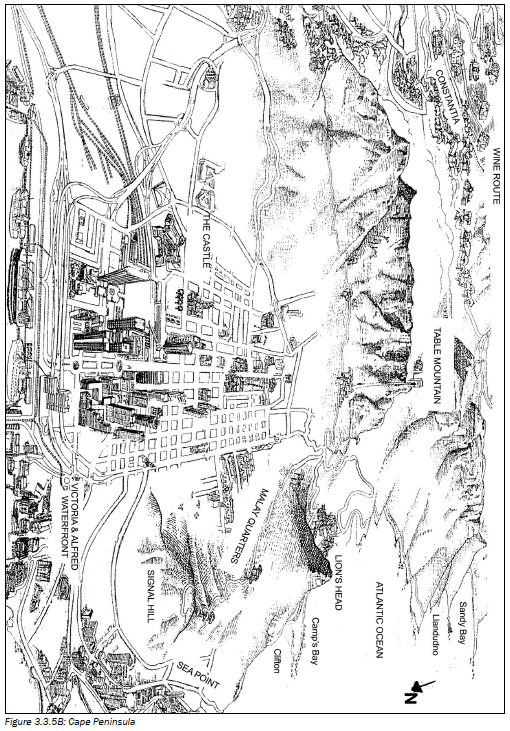
442.4

  1. What do the letters CBD stand for? (1 × 2 = 2)
  2. Identify the street pattern of the CBD of Cape Town. (1 × 2 = 2)
  3. Provide one advantage and one disadvantage of this street pattern. (2 × 2 = 4)
  4. With reference to Figure 3.7, identify one characteristic of the CBD’s profile. (1 × 2 = 2)
  5. Explain why the CBD has the characteristic you identified in question d). (2 × 2 = 4)

2.5 What evidence is there that the CBD of Cape Town is the most accessible land use zone? (1 × 2 = 2)

[24]

Question 3
Refer to the residential areas of Sea Point and the Malay Quarters.
3.1

  1. Classify the two areas as low- or high-income areas respectively. (2 × 2 = 4)
  2. Explain your classification of Sea Point in question a) by referring to evidence from Figure 3.7. (2 × 2 = 4)

3.2 The open space around the Malay Quarter may attract migrants from the rural areas.

  1. What is likely to develop here as a result of this migration? (1 × 2 = 2)
  2. Explain the occurrence of this development. (2 × 2 = 4)
  3. State two reasons for these migrants leaving the rural areas. (2 × 2 = 4)
  4. What problems are associated with this development? (2 × 2 = 4)
  5. You are part of a task team set up by the government to provide suggestions on how to slow the movement of people from the rural areas, as well as attract people back to small towns. In a short paragraph (no more than 12 lines), discuss some of your suggestions. (6 × 2 = 12)
    [34]

Question 4
4.1 Provide the correct term for the following phrases:

  1. A settlement where only primary activities occur (1 × 2 = 2)
  2. An urban settlement which consists of a main city with surrounding dependent towns (1 × 2 = 2)
  3. The increase in the number of people living in an urban area (1 × 2 = 2)
  4. A resource from the earth which cannot be replenished. (1 × 2 = 2)
  5. The economic sector which involves the accessing and distribution of information. (1 × 2 = 2)

4.2 Match the columns. Simply write the number of the term in Column A next to the letter of the correct phrase from Column B.

Column A  Column B 
  1. Junction town
  2. Zone of decay
  3. Centrifugal forces
  4. Intensive farming
  5. Spatial development initiatives
 
  1. Plans to provide basic needs to all areas
  2. Farmland with a high carrying capacity
  3. Reasons why people leave a CBD or city
  4. Plans to improve the peripheral areas
  5. An old area in the CBD
  6. A town formed where two rivers meet
  7. An area around the CBD with mixed functions
  8. A town formed at a point where two major transport routes meet (5 × 2 = 10)
    [20]


Answers to activity 3.7
Question 1
1.1 An individual farmstead on its own piece of land.  (2)
1.2 All profit is your own /Make own decisions / Make effective use of machinery /Less time wasted travelling to work.(any 2) (4)
1.3 Little social interaction /Less help in times of trouble / No sharing of ideas. (any 2) (4)
1.4 Primary activities refer to the extraction of raw material from the Earth. The growing of grapes is a primary activity. 
Secondary activities refer to the manufacturing of raw material into processed goods. Making wine from grapes is a secondary activity. 
Tertiary activities refer to the provision of services and selling of goods. Wine farms sell wine/have restaurants and wine tasting which attracts tourists. (12)
[22]

Question 2
2.1 A site is the exact piece of land a settlement is found on. (2)
2.2 Available flat land /Natural harbour providing access to the ocean (4)
2.3 It has a harbour where the mode of transport changes, e.g from land to sea. (2)
2.4

  1. Central Business District(2)
  2. Gridiron street pattern(2)
  3. Advantage: Easy to find your way /Easy to extend / Easy to subdivide(any 1)
    Disadvantage: Causes traffic congestion /Monotonous (boring) layout (any 1) (4)
  4. Tall buildings/Skyscrapers(2)
  5. Land is in demand so price increases /Cheaper to build upwards(any 1) (4)

2.5 All transport routes converge in the CBD. 33 (2)
[24]

Question 3
3.1

  1. Sea Point – high income ; Malay Quarter – low income (4)
  2. Has sea view, which increases land value /On outskirts city; residents can afford transport costs (any 1) (4)

3.2

  1. Informal settlement (squatter settlement) (2)
  2. Migrants are uneducated so they cannot find a job They cannot afford rent or to buy a house3(4)
  3. Family land not big enough to divide among children / Traditional farming methods so low food output / Inadequate services and facilities /Droughts and floods have greater impact /Farm workers evicted / Job losses due to increased mechanisation(any 2) (4)
  4. High degree of unemployment /Social problems, such as violence and crime, more common / Increase in litter and pollution /Waterborne diseases common /Increased spread of diseases (any 2) (4)
  5. Need to speak to community and find out their needs / Find out skills and talents in area /Need to set up industry in area based on local skills or raw materials or products / Improve farming methods of subsistence farmers /Possibly change to commercial cash crops/Small towns advertise attractions in their town/Find ways to attract tourists, for example lodges, casinos, holiday resorts, etc. / Develop or market the town as a commuter or retirement town / Petition government to maintain services and facilities  (any 6 facts; include points for both rural areas and towns) (12)
    [34]

Question 4
4.1

  1. Rural
  2. Metropolis
  3. Urban growth
  4. Natural, non-renewable resource
  5. Quaternary (10)

4.2

  1. – viii)
  2. – vii)
  3. – iii)
  4. – ii)
  5. – iv) (10) 

[20]

Last modified on Friday, 03 September 2021 07:30