1. Multiple-choice questions
Example:
Another name for a mid-latitude cyclone is:

  1. Temperate cyclone
  2. Tropical storm
  3. Typhoon
  4. Tropical cyclone
    (Correct answer is underlined)

2. Short answer questions
Example:
List two characteristics of a tropical cyclone.
Answer:

  1. Accompanied by thunderstorms
  2. Eye in the centre
  3. Draw a cross-section from A to B

For example, see Figures 1.2.2A and 1.2.3B.

Activity 1
Study the synoptic weather chart in Figure 1.3.3B below and answer the questions that follow.
21

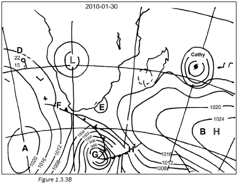
  1. Name the high pressure cells labelled A and B. (2 × 2 = 4)
  2. Give TWO pieces of evidence from the map that this is a summer map. (2 × 2 = 4)
  3. Identify the low pressure cell labelled E. (1 × 2 = 2)
  4. The letter G indicates a mid-latitude cyclone.
    1. Name the fronts labelled F and H. (2 × 2 = 4)
    2. In which direction does this cyclone generally move? (1 × 2 = 2)
    3. Describe how front F will affect the weather of Cape Town. (3 × 2 = 6)
  5. Refer to the cyclone named Cathy.
    1. What type of cyclone is Cathy? (1 × 2 = 2)
    2. State how many cyclones have occurred for this season, including Cathy. (1 × 2 = 2)
    3. In which direction does this cyclone move? (1 × 2 = 2)
    4. List TWO conditions necessary for this cyclone to form. (2 × 2 = 4)
  6. Refer to the weather station labelled D and describe the weather in terms of: cloud cover, wind speed, wind direction, air temperature, dewpoint temperature. (4 × 2 = 8)
    [40]

Answers to activity 1

  1.  
    1. South Atlantic high pressure
    2. South Indian high pressure (4)
  2. A tropical cyclone can be seen on the map.
    Mid-latitude cyclones are seen south of South Africa.
    The South Indian and South Atlantic high pressures are south of South Africa.
    A low pressure cell can be seen over the centre of South Africa.
    The date: 30/01/201033 (any 2) (4)
  3. Coastal low pressure (2)
  4.  
    1. F – Cold front; H – Warm front (4)
    2. In an easterly direction/from west to east (2)
    3. Temperatures will decrease; pressure will increase;
      Cumulonimbus clouds and thunderstorms will occur (6)
  5.  
    1. Tropical cyclone (2)
    2. Three (2)
    3. Westerly/from east to west (2)
    4. Temperature must be above 27°C; Humidity must be high; There must only be light and variable wind;
      The atmosphere must be unstable; There must be a wide area of low pressure with closed isobars; It must be between 5°S and 25°S (needs Coriolis force);
      Little surface friction (any 2) (4)
  6. Cloud cover: Clear skies; Wind speed: 10 knots;
    Wind direction: SSE; Air temperature: 22°C;
    Dewpoint temperature: 15 °C (8)
    [40] 

Activity 2
Figure 1.4.2B (left) illustrates valley climates. Study the diagram and answer the questions that follow.
25

  1. Name the valley winds depicted in A and B. (2 × 2 = 4)
  2. State ONE advantage of the wind labelled A. (1 × 2 = 2)
  3. Name the layer labelled C. (1 × 2 = 2)
  4. Explain how the wind labelled B influences:
    1. Farming in the valley (2 × 2 = 4)
    2. Industry in the valley (2 × 2 = 4)
      [16]

Answers to activity 2

  1.  
    1. Anabatic wind/upslope wind
    2. Katabatic wind/downslope wind/gravity wind(4)
  2. It can carry pollution out of the valley. (2)
  3. Inversion layer/thermal belt (2) 
  4.  
    1. Winds bring cold air into the valley.
      These winds cause a frost pocket to form.
      The frost can kill the crops. (4)
    2. Cold conditions make working conditions in the industry difficult.
      Pollution produced by the industry will be trapped in the valley. (4)
      [16]
Last modified on Friday, 03 September 2021 07:30